Maps: 1601 - 1622

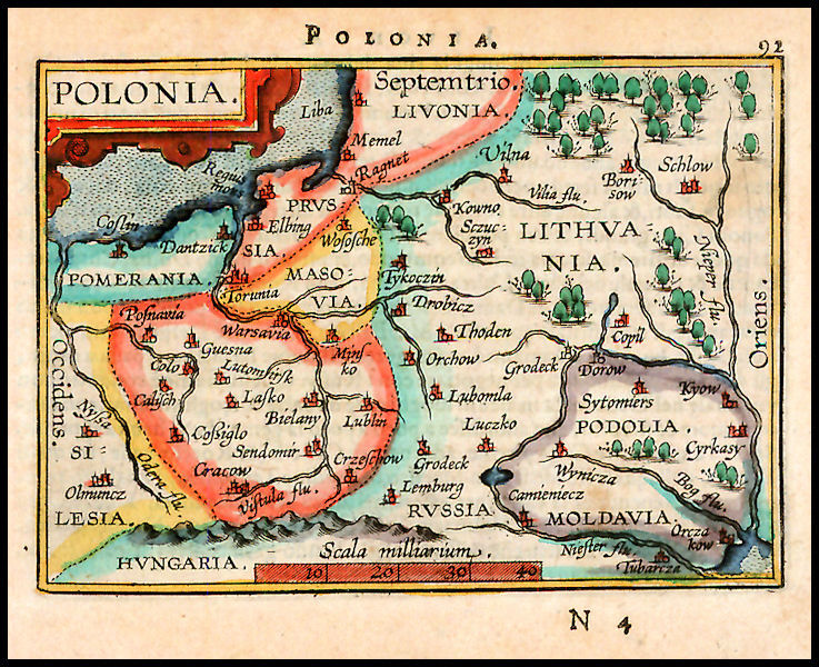
1601 Abraham Ortelius
(Engraver) - Giovanni
Battista Vrients
(Publisher) : "POLONIA."
Antwerp, 5 x 3.5 inches.
Hand-colored example of
Ortelius' miniature map of
Poland-Lithuania, from
the first edition of
“Ortelius Epitome.”
(Engraver) - Giovanni
Battista Vrients
(Publisher) : "POLONIA."
Antwerp, 5 x 3.5 inches.
Hand-colored example of
Ortelius' miniature map of
Poland-Lithuania, from
the first edition of
“Ortelius Epitome.”
1601 Abraham Ortelius:
"POLONIA," Antwerp,
from "Epitome Theatri
Ortelani." From
www.alabamamaps.ua.edu
"POLONIA," Antwerp,
from "Epitome Theatri
Ortelani." From
www.alabamamaps.ua.edu

| 1602-09 Petrus Bertius - Jodocus Hondius (publisher): "POLONIA," 3.5 x 5 inches / 90 x 125 mm, in three different versions, from different editions of Bertius's "Tabularum Geographicarum Contractarum." Map on the top left from www.beachmaps.com; on the left bottom, c1609, from www.alteagallery.com; on the top right, a 1603 version with a DETAIL image on the right bottom from eBay |

1603 Vaclovas Grodeckis - Abraham Ortelius:
"POLONIAE, LITVANAE Q DESCRIPTIO." 15 x 19
inches, in two differently-colored versions. From
"Theatrum Orbis Terrarum," Antwerp. Compare with
the 1609 version below. On the left: www.raremaps.com; on
the right: www.the antiquarium.com
"POLONIAE, LITVANAE Q DESCRIPTIO." 15 x 19
inches, in two differently-colored versions. From
"Theatrum Orbis Terrarum," Antwerp. Compare with
the 1609 version below. On the left: www.raremaps.com; on
the right: www.the antiquarium.com

1604 Abraham Ortelius:
"POLONIA." from
"Epitome Theatri
Ortelani."
"POLONIA." from
"Epitome Theatri
Ortelani."

| 1607 Gerard Mercator - Jodocus Hondius: "LITHUANIA," 5.5 x 7.25 inches. Mercator devoted his later life to "Atlas Minor," the last of 3 vols. published in 1595, a year after his death. The plates were bought in 1604 by Hondius, who republished it in 1607. AK-10. |

1610 Gerard Mercator - Jodocus Hondius: "LITHUANIA," 138mm x 181mm, in four slightly different versions
published the same year, all from "Atlas Minor." Note "LITHVANIE" above the left-most map image, from
www.librarie-lebail.fr. Note "LITHVANIA" above both the second map, which is from www.raremaps.com, and the third,
colored, map, which is from the National Library of Latvia: http://data.lnb.lv/nba05/kartes/frame_anglu.htmThe fourth map is
from www.oldworldauctions.com.


1613-43 Hessel Gerritsz (engraver) - Willem Blaeu: "MAGNI DVCATVS LITVANIAE," 28.9 x 29.3 inches, Amsterdam. An important 4-sheet wall map engraved (all maps have the
date "1613" on the second cartouche) from survey drafts prepared by M. Strubicz under instructions of Prince Nicolas Christophe Radziwill. These examples are by Willem Blaeu,
under his imprint “Guilhelmus Janssoni." This map was not included in an atlas until 1630. The fourth map includes an additional two sheets depicting the lower part of the Dnieper
River. All versions are from www.raremaps.com


1613 Hessel Gerritsz - Willem Blaeu: "MAGNI
DVCATVS LITHVANIAE," disassembled, in four
sheets. From the New York Public Library collection, at
www.digitalgallery.nypl.org
DVCATVS LITHVANIAE," disassembled, in four
sheets. From the New York Public Library collection, at
www.digitalgallery.nypl.org


1620 Mercator - Johannes Janssonius: "LITHUANIA,"
14.5 x 20 cm / 5.7 x 8 inches, from Mercator's small
atlas, in two versions, with a DETAIL image of the second map, which is from the National Library of
Latvia: http://data.lnb.lv/nba05/kartes/frame_anglu.htm
14.5 x 20 cm / 5.7 x 8 inches, from Mercator's small
atlas, in two versions, with a DETAIL image of the second map, which is from the National Library of
Latvia: http://data.lnb.lv/nba05/kartes/frame_anglu.htm


| 1603 Petrus Bertius: "Livoniae descrip.," Amsterdam, 9 x 12 cm, from his "Tabulrium Geographicarum Contractarum Libri Quinque." Fromthe EstonianNational Library Cartography Collection: www.nlib.ee |
1606 Petrus Bertius: "Livoniae descrip," Amsterdam,
3.4 x 4.9 inches / 8.7 x 12.4 cm. A later version of
the map to the left, Also a DETAIL image. From
www.swaen.com
3.4 x 4.9 inches / 8.7 x 12.4 cm. A later version of
the map to the left, Also a DETAIL image. From
www.swaen.com


1616 Petrus Bertius:
"POLONIAE," Amsterdam, 95
x 135 mm, printed from the
second plate of two used to
illustrate his "Geography,"
with thicker printed borders.
From www.alteagallery.com
"POLONIAE," Amsterdam, 95
x 135 mm, printed from the
second plate of two used to
illustrate his "Geography,"
with thicker printed borders.
From www.alteagallery.com

1613-16 Gerard Mercator -
Jodocus Hondius: "LITHVANIA," 37 x 44 cm / 14.4 x 17.2 inches, verso text in French -- a map whose first edition
appeared in 1595. From Mercator's "L'Atlas ou Meditations Cosmographiques de la Fabrique du Monde et Figure
diceluy, I Honij." Also two DETAIL images. From www.sanderusmaps.com. This version is a close approximation of AK-05


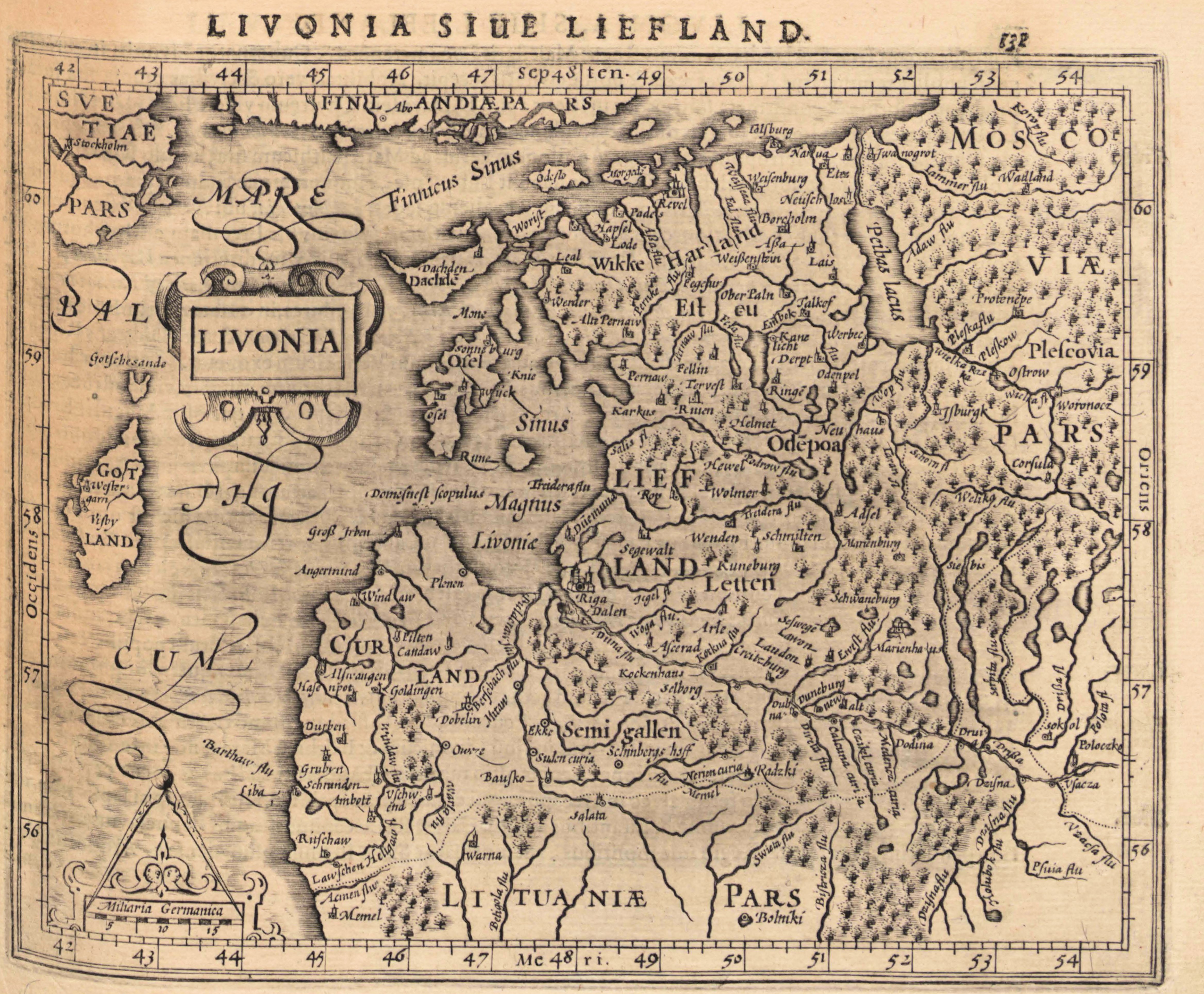
1621 Gerard Mercator: "LIVONIA,"
Arnheim, from his "Atlas Minor," published
by Johannes Janssonius. From the Univ. of
Tartu: http://dspace.utlib.ee/dspace/
Arnheim, from his "Atlas Minor," published
by Johannes Janssonius. From the Univ. of
Tartu: http://dspace.utlib.ee/dspace/

1606 Petrus Bertius: "Livoniae descrip.,"
Amsterdam, in an uncolored version. From
the Univ. of Tartu, http://dspace.utlib.ee/dspace/
Amsterdam, in an uncolored version. From
the Univ. of Tartu, http://dspace.utlib.ee/dspace/

1609, 1612 Vaclovas Grodeckis - Abraham Ortelius: "POLONIAE, LITVANAE Q
DESCRIPTIO." 15 x 19 inches, in two versions, one from 1609 and one from 1612,
both from "Theatrum Orbis Terrarum," Antwerp. This version includes corrections
noted by Van Den Broecke on the Dniester River, which were first made in 1598.
The map is based upon the maps of Grodeckis, published in 1558, 1562, as corrected
by Pograbka. Grodecki's map itself is based on a 1526 map by Wapovsky. The 1612
version also has a DETAIL image. Map on the left is from www.raremaps.com; map on the right
from www.swaen.com


1601 - 1612 Abraham Ortelius - Michel Coignet: "LIVONIA," Antwerp, 3.3 x 4.5 inches / 8.5 x 11.5 cm. Coignet
wrote the text for miniature editions of Ortelius (who died 1598), published 1601-12 by Jan Baptise Vrients:
"Epitome theatri orbis terrarum Abrahami Ortelij." The engravings were done by Ambrose and Ferdinand
Arsenius. The first map is from www.swaen.com; the second map is from The Naional Library of Estonia: http://www.nlib.ee/; the third
and fourth maps are from the National Library of Latvia: http://data.lnb.lv/nba05/kartes/frame_anglu.htm


c1598-1606 Petrus
Bertius: "Livoniae
descrip.," Amsterdam,
from a Dutch pocket
atlas, 12.5 x 9 cm. From
www.jpmaps.co.uk
Bertius: "Livoniae
descrip.," Amsterdam,
from a Dutch pocket
atlas, 12.5 x 9 cm. From
www.jpmaps.co.uk
1602
1609
1603


Jodocus Hondius: "DESCRIPTIO LIVONIAE," Amsterdam, 13 x 9 cm, in a 1616
colored version, and a 1618 uncolored version, both after Ortelius. Also a DETAIL
image of the 1618 version. 1616 map from The National Library of Latvia:
http://data.lnb.lv/nba05/kartes/frame.htm; 1618 map from http://digital.ub.uni-duesseldorf.de/
colored version, and a 1618 uncolored version, both after Ortelius. Also a DETAIL
image of the 1618 version. 1616 map from The National Library of Latvia:
http://data.lnb.lv/nba05/kartes/frame.htm; 1618 map from http://digital.ub.uni-duesseldorf.de/


1618 Jodocus Hondius - Petrus Bertius: "POLONIA," Amsterdam, in two versions, with a DETAIL image of each.
The maps are from "Tabularum Geographicarum Contractarum…," a pocket atlas that was published 1600 to
1650. Bertius wrote the commentary. His two brothers-in-law, Hondius and Pieter vn den Keere, engraved the
maps. First map from http://digital.ub.uni-duesseldorf.de/ ; second map from www.oldworldauctions.com


1609 Abraham Ortelius:
"POLONIA," Antwerp, 3
3/8 x 4 3/4 inches, from
"Epitome Theatri Orbis
Terrarum." From
antiqueatlas on eBay
"POLONIA," Antwerp, 3
3/8 x 4 3/4 inches, from
"Epitome Theatri Orbis
Terrarum." From
antiqueatlas on eBay

1616 1618
1603 - 1604 Abraham Ortelius: "LIVONIA," Antwerp,
published by Jan Baptiste Vrients in English editions of
Ortelius' atlas. The first map is from the National Library of
Estonia: http://www.nlib.ee; the second, colored, map is from the
National Library of Latvia:
http://data.lnb.lv/nba05/kartes/frame_anglu.htm
published by Jan Baptiste Vrients in English editions of
Ortelius' atlas. The first map is from the National Library of
Estonia: http://www.nlib.ee; the second, colored, map is from the
National Library of Latvia:
http://data.lnb.lv/nba05/kartes/frame_anglu.htm


1613 Gerard Mercator:
"LIVONIA," France, 14.5 x
19 cm, from "Atlas Minor."
From the National Library of
Latvia: http://data.lnb.lv
"LIVONIA," France, 14.5 x
19 cm, from "Atlas Minor."
From the National Library of
Latvia: http://data.lnb.lv