Maps: 1731 - 1739

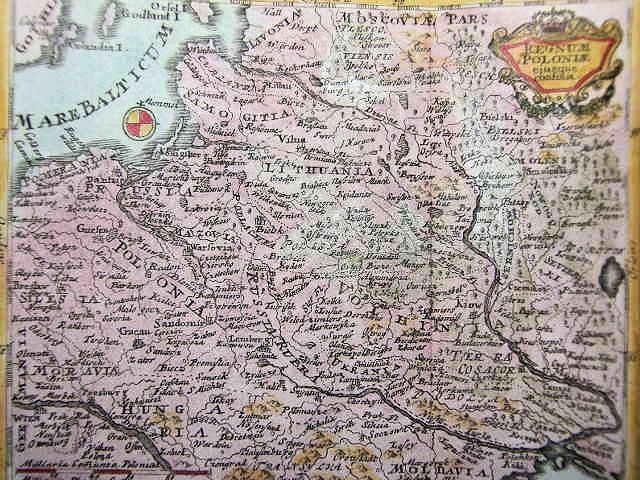
1732 Herman Moll: "POLAND Subdivided into its several Palatinates &c," London, in
threeversions, with the engraved area 10 1/4 x 7 5/8 inches, from his "Atlas Minor."
Compare with the 1728, 1736 and 1740 versions. Second map from
fineantiquemapsandprints on eBay; third map from www.raremaps.com
threeversions, with the engraved area 10 1/4 x 7 5/8 inches, from his "Atlas Minor."
Compare with the 1728, 1736 and 1740 versions. Second map from
fineantiquemapsandprints on eBay; third map from www.raremaps.com

1733 Patrick Gordon: "A
new map of POLAND
from the lateft Obfer."
new map of POLAND
from the lateft Obfer."


1733 Isaa(c)k Tirion: "NIEUWE KAART VANT KONINKRYK POOLEN...," 28.5 x 34.5 cm., in four versions, the first
being the earliest -- the others are newer versions, according to the cartouche. Also see a similar, 1736, map by
Tirion, below. First version, on the top left, from cesgia on eBay; Second version from www.mapmogul.com; fourth version from iscra on
eBay
being the earliest -- the others are newer versions, according to the cartouche. Also see a similar, 1736, map by
Tirion, below. First version, on the top left, from cesgia on eBay; Second version from www.mapmogul.com; fourth version from iscra on
eBay

1735 Covens & Mortier:
"LA POLOGNE. Suivant
Les Nouvelles Observa-
tions...," Amsterdam, 9 x
11.5 inches. From "Nouvel
Atlas" by Van der Aa. (See
the 1936 version below.)
From www.gracegalleries.com
"LA POLOGNE. Suivant
Les Nouvelles Observa-
tions...," Amsterdam, 9 x
11.5 inches. From "Nouvel
Atlas" by Van der Aa. (See
the 1936 version below.)
From www.gracegalleries.com


1735 J.F. Betgen - Homann
Heirs (Publishers): "LITHU-
ANIAM BORUSSICAM..." 49
x 58.5 cm., in three versions:
a top half of the full map (from
www.gallica. bnf.fr); the second is
both parts, separately, and
the third version (from the Univ.
of Freiburg: http://dl.ub.uni
-freiburg de/diglit/karten sammlung
_bd12 /0037?sid=
5b12ccc143331dba8bd164
465833a6ac&zoomlevel=4) is the
full map in one image.

1735 Matthaus Seutter:
"Novissima et accuratiss-
ima MAGNI DUCATUS
LITHUANIAE..."
"Novissima et accuratiss-
ima MAGNI DUCATUS
LITHUANIAE..."

1735 Matthaus Seutter:
"POLONIAE REGNUM ut
et REGNI DUCATUS
LITHUANIAE," 58 x 50
cm., in the second state of
the plate: see 1728-30 for
other and better images.
From www.jpmaps.co.uk
"POLONIAE REGNUM ut
et REGNI DUCATUS
LITHUANIAE," 58 x 50
cm., in the second state of
the plate: see 1728-30 for
other and better images.
From www.jpmaps.co.uk

1736 Nicolas de Fer: "LES ETATS DE LA
COURONNE DE POLOGNE," 23 x 18.5
inches, Paris. First engraved by
Starckman, and issued by de Fer in 1716,
followed by editions in 1736, '60 and '82.
COURONNE DE POLOGNE," 23 x 18.5
inches, Paris. First engraved by
Starckman, and issued by de Fer in 1716,
followed by editions in 1736, '60 and '82.

1738 Jacques Benigne Bossuet: "ESTATS de la Couronne
de POLOGNE," Amsterdam, 5 3/8 x 6 5/8 / 14 x 17 cm,
in uncolored and colored versions. Colored map from
adlers-raritaetentruhe on eBay
de POLOGNE," Amsterdam, 5 3/8 x 6 5/8 / 14 x 17 cm,
in uncolored and colored versions. Colored map from
adlers-raritaetentruhe on eBay


1738 Haupt - Beck: "REGNUM POLONIAE." In two colored and one uncolored (AK-20)
versions. The left colored version is from www.mapmogul.com; the right colored version is from
Antiqua Rare Books, Markkleeberg, Germany
versions. The left colored version is from www.mapmogul.com; the right colored version is from
Antiqua Rare Books, Markkleeberg, Germany

1739 Johann Homann, published by Adelbauer - Johann Gabriel Doppelmayr: "REGNI POLONIAE, MAGNIQUE
DUCATUS LITHUANIAE Nova et exacta tabula, ad mentem Starovolcii, " Nürnberg, in four versions dated, but not
necessarily published, in 1739, from the "Atlas factice" of 42 maps, produced by the Homann Erben firm. Note the
poorly-erased former engraving in the secondd map's cartouche. First map from
http://gauss.suub.uni-bremen.de/suub/hist/index.jsp; second map from http://dspace.utlib.ee/dspace; third map from National Library of
Latvia: academia.lndb.lv; fourth map from Beinecke Rare Book and Manuscript Library, Yale Univ.
:http://brbl-dl.library.yale.edu/vufind/Record/3444622 ; fifth map


1739 Johann Georg
Schreiber: "... KONIG-
REICH POLEN...," 7 x 10
inches. See the 1730,
1749 versions.
Schreiber: "... KONIG-
REICH POLEN...," 7 x 10
inches. See the 1730,
1749 versions.

1736 Isaa(c)k Tirion: NUOVA CARTA del
REGNO DI POLONIA," Amsterdam, 13 x
11 inches. From www.raremaps.com
REGNO DI POLONIA," Amsterdam, 13 x
11 inches. From www.raremaps.com

1736 Covens & Mortier:
"LA POLOGNE," Amster-
dam. From REGION
MAZOWIECKIE WARSAW
internet. mazovia.en
DEPARTMENT of Geodesy and
Cartography
"LA POLOGNE," Amster-
dam. From REGION
MAZOWIECKIE WARSAW
internet. mazovia.en
DEPARTMENT of Geodesy and
Cartography


1739 Thomas Kitchin: "A MAP of the Eastern
Part of POLAND," London, 8.9 x 7 inches / 22.5
x 17.8 cm, as published in London Magazine,
with a DETAIL image. From www.swaen.com
Part of POLAND," London, 8.9 x 7 inches / 22.5
x 17.8 cm, as published in London Magazine,
with a DETAIL image. From www.swaen.com
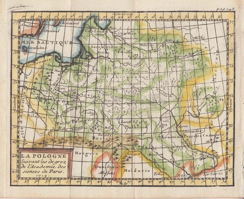
1739 Claude Buffier: "LA
POLOGNE," dated 1714,
5.5 x 7 inches, from his
"Geographie Universelle."
From Beach Antique Maps &
Prints on eBay
POLOGNE," dated 1714,
5.5 x 7 inches, from his
"Geographie Universelle."
From Beach Antique Maps &
Prints on eBay

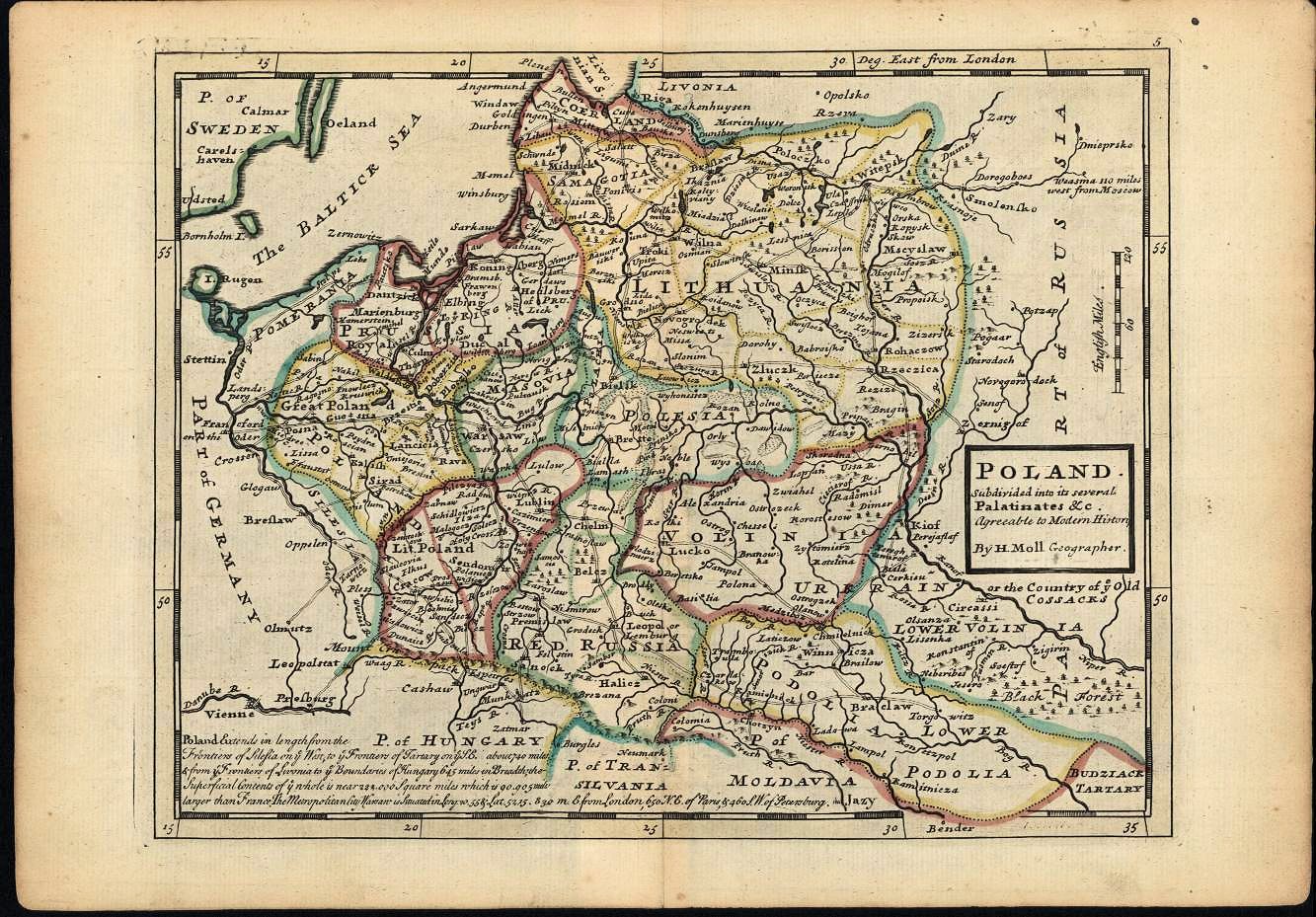

1736 Herman Moll: "POLAND," London, 21
x 26 cm., from the third edition of his
"Atlas Minor." Compare with the '28, '32
and '40 versions. From www.davidrumsey.com
x 26 cm., from the third edition of his
"Atlas Minor." Compare with the '28, '32
and '40 versions. From www.davidrumsey.com


1732 Paul de La Feuille: "Le Royaume De
Pologne Avec Ses Confins," Amsterdam, map
17 x 13 cm. Also a DETAIL image. Compare
with versions from 1702, 1707, 1717, 1747
and 1753. From http://digital.ub.uni-duesseldorf.de/
Pologne Avec Ses Confins," Amsterdam, map
17 x 13 cm. Also a DETAIL image. Compare
with versions from 1702, 1707, 1717, 1747
and 1753. From http://digital.ub.uni-duesseldorf.de/

c1735 I have two attributions for this map: one copy I
own, by Jennvilliers: "Royaume de Pologne." 9.5 x
15.5 inches, Paris, published 1700-1755 by Jean
Baptiste Nolin. AK-08 The seemingly identical map
(from lindisfarne2 on eBay) without the on-map
attribution to Jennvilliers, is by Nicolas Lenglet Du
Fresnoy, Paris, 1735 by Pierre Gandouin in;
"Methode Pour Etudier L'Histoire" by M. L'Abbe
Lenglet Du Fresnoy.


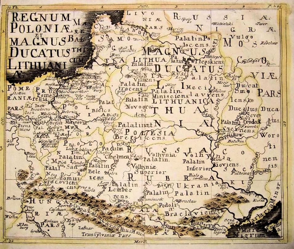
1737 Johann Jacob Lidl
(engraver): "REGNUM
POLONIAE et MAGNUS
DUCATUS LITHUANI."
From gkrgrec on eBay
(engraver): "REGNUM
POLONIAE et MAGNUS
DUCATUS LITHUANI."
From gkrgrec on eBay


1733 Johann Schreiber: "Reise Charte durch das König-
reich Polen: mit allen darzu gehörigen Laendern / verfer- tiget von
J[ohann] G[eorg] Schreibern inLeipzig," from his "Atlas Minor."
Compare with the 1730 and 1739 versions. From artlusatica on eBay
reich Polen: mit allen darzu gehörigen Laendern / verfer- tiget von
J[ohann] G[eorg] Schreibern inLeipzig," from his "Atlas Minor."
Compare with the 1730 and 1739 versions. From artlusatica on eBay

1733-34 Anselm Desing:
"XXVI Haupt Karte POLEN,"
fromthe first edition of his
"Historica Auxilia," also
published 1741 and
1746-47. From www.karty.by
"XXVI Haupt Karte POLEN,"
fromthe first edition of his
"Historica Auxilia," also
published 1741 and
1746-47. From www.karty.by


1739 J.B. Homan:
"REGNI POLONIAE,
MAGNIQUE DUCATUS
LITHUANIAE Nova et
exacta tabula, ad
mentem Starovolcii, "
Nürnberg. Cartouch
slightly differs from the
other 1739 versions
above. From from the
National Library of France:
www.gallica.bnf.fr
"REGNI POLONIAE,
MAGNIQUE DUCATUS
LITHUANIAE Nova et
exacta tabula, ad
mentem Starovolcii, "
Nürnberg. Cartouch
slightly differs from the
other 1739 versions
above. From from the
National Library of France:
www.gallica.bnf.fr
