Maps: 1740 - 1749

1740 J.B. Nolin: "Le
Royaume de Pologne,"
45.5 x 60.5 cm. From
www.mapmogul.com
Royaume de Pologne,"
45.5 x 60.5 cm. From
www.mapmogul.com

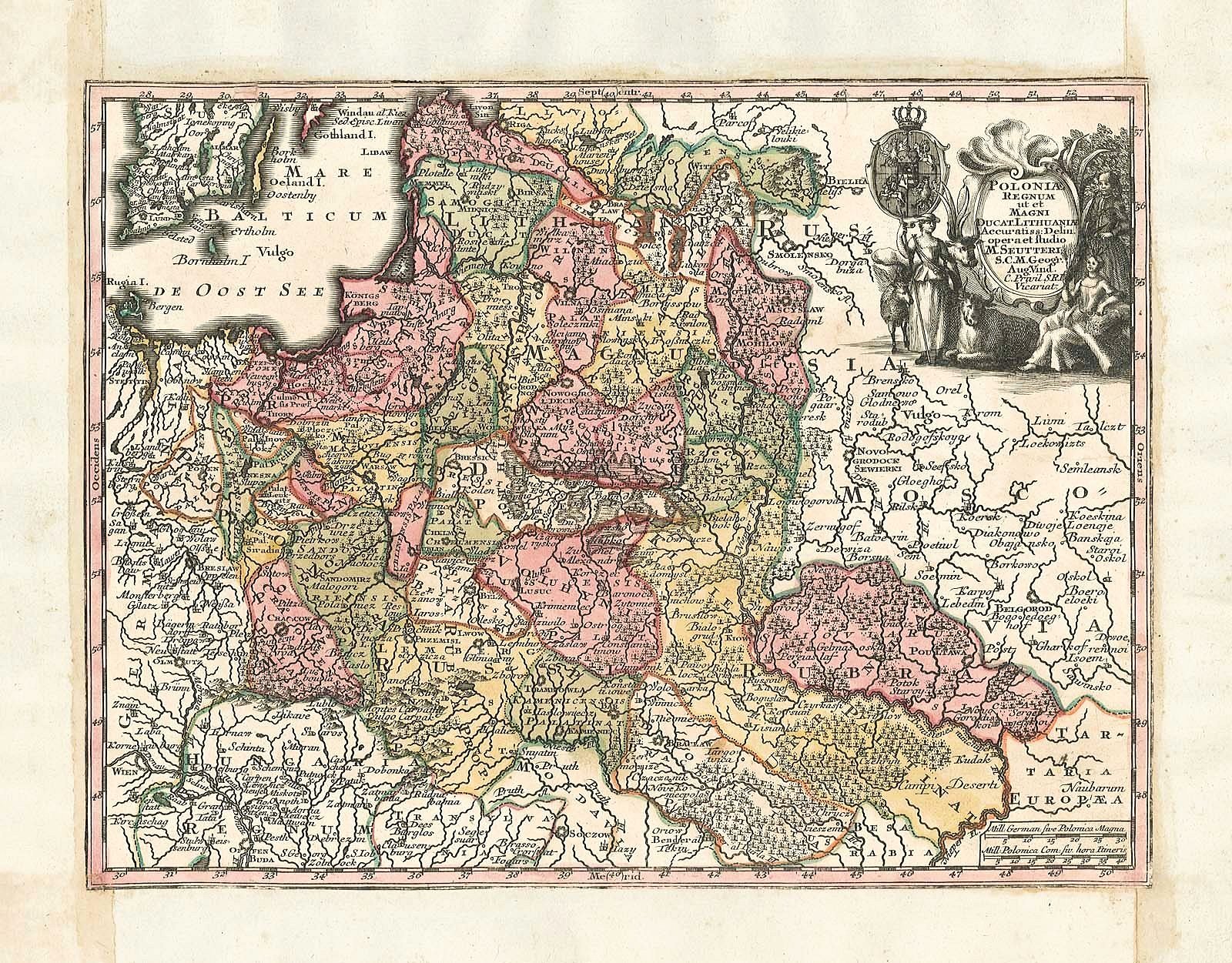
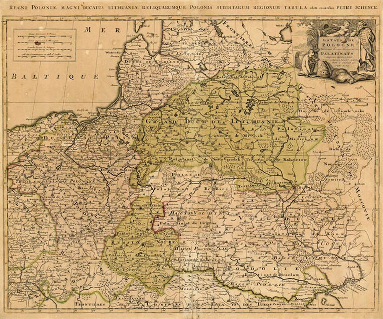
c1740 R. & J. Ottens: "Reipublicae et Status Generalis Poloniae Nova
Tabula, Comprehendens Maioris et Minoris Poloniae Regni..." Amsterdam,
20 x 35 inches / 51 x 89 cm., in two versions. First map from Robt. Putnam;
second and detail image from www.swaen.com
Tabula, Comprehendens Maioris et Minoris Poloniae Regni..." Amsterdam,
20 x 35 inches / 51 x 89 cm., in two versions. First map from Robt. Putnam;
second and detail image from www.swaen.com

1740 John Senex: "A new
Map of POLAND from the
lateft Obfer,"from
Gordon's "Geography
Anatomiz'd." From
www.antiquemaps.org.uk
Map of POLAND from the
lateft Obfer,"from
Gordon's "Geography
Anatomiz'd." From
www.antiquemaps.org.uk
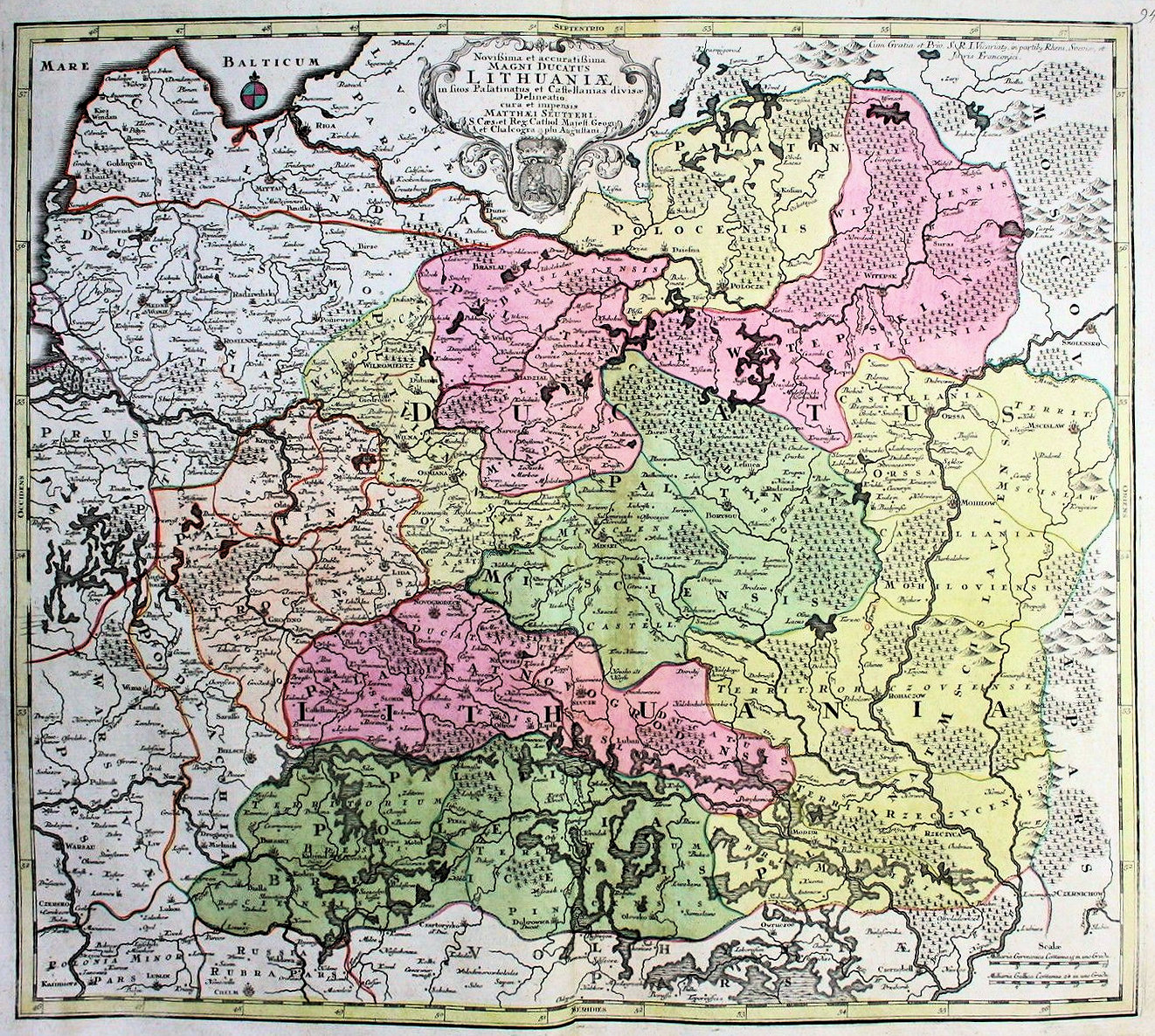
Matthaus Seutter: "Novissima et accuratissima MAGNI DUCATUS LITHUANIÆ,"
Augsburg, 20 x 23 inches, in three versions of the Second State, identified by the
presence of the "privilege under the top right border. First map from babi_de on eBay; third,
first 1742 map, from senizemelepiai.lt; second 1742 map: The Wroblewski Library of the Lithuanian
Academy of Sciences: elibrary.mab.lt/

1740 Matthaus Seutter:
"POLONIÆ REGNUM UT
ET MAGNI DUCATUS
LITHUANIAE," Augsburg,
in the second state. From
www.alexandremaps.com
"POLONIÆ REGNUM UT
ET MAGNI DUCATUS
LITHUANIAE," Augsburg,
in the second state. From
www.alexandremaps.com

Isaac Tirion (publisher): "Nieuwe Kaart von ket Koninkryk Poolen...," Amsterdam, in 1740 and 1745 editions of "Nieuwe
enbeknopte hand-atlas," published in six editions from 1740 to 1784. Also two DETAIL images of the first 1740 map. First 1740 map
from luschnoar on eBay; second from www.auction.catawiki.com; first 1745 map from www.putmap.com; second from wwwauction.catawiki.com
enbeknopte hand-atlas," published in six editions from 1740 to 1784. Also two DETAIL images of the first 1740 map. First 1740 map
from luschnoar on eBay; second from www.auction.catawiki.com; first 1745 map from www.putmap.com; second from wwwauction.catawiki.com

1741 Anselm Desing:
"XXVI Haupt Karte
POLEN," from the 1741
edition of his "Historica
Auxilia," also published
1733-34, and 1746-47.
"XXVI Haupt Karte
POLEN," from the 1741
edition of his "Historica
Auxilia," also published
1733-34, and 1746-47.


1742 Jean Baptiste Renou
de Chauvigne- Jaillot: "LA
POLONIA."
de Chauvigne- Jaillot: "LA
POLONIA."
1742 Guillaume Delisle: "La Pologne...,"
Amsterdam, 49 x 62 cm, in 5th state
from "Atlas Nouveau," first published
by Covens & Mortier 1730. From
www.davidrumsey.com
Amsterdam, 49 x 62 cm, in 5th state
from "Atlas Nouveau," first published
by Covens & Mortier 1730. From
www.davidrumsey.com

1744 Claude Buffier (publisher) - F. Desbruslins. pere.
(engraver): "LA POLOGNE Suivant les degres de
l'Academie des Sciences de Paris," Charlevoix, 13.7 x
17.6 inches and 5.5 x 7 inches, in two versions from
"Geographie Universelle." Compare with the 1752
version. Larger map on the left from www.mapmogul.com; map
on the right from www.murrayhudson.com
(engraver): "LA POLOGNE Suivant les degres de
l'Academie des Sciences de Paris," Charlevoix, 13.7 x
17.6 inches and 5.5 x 7 inches, in two versions from
"Geographie Universelle." Compare with the 1752
version. Larger map on the left from www.mapmogul.com; map
on the right from www.murrayhudson.com

1744 Matthaus Seutter (publisher) - Tobias Conrad Lotter (engraver): "Poloniae
Regnum ut et Magni Ducat. Lithuaniae Accuratiss. Delin. opera et studio M.
Seutteri, S.C.M. Geogr. Aug. Vindel. C. Privil. S.R. I. Vicariat. Tob. Conr. Lotter
sculpsit.", Augsburg, 7.5 x 10 inches, in three versions. From "Atlas minor praecipua
orbis terrarum imperia..." Compare with 1740 and 1750 versions. First map from ruggis
on eBay; third map from www.davidrumsey.com

1748 Georges Louis Le Rouge: "LA POLOGNE," Paris, 10.5 x 8 inches, in the first state, in four differently-colored
versions. The map was included in the "Atlas Nouveau Portatif." The third, farthest-right version is from
www.oldworldauctions.com; the fourth is from antykwariat raraavis.krakow
versions. The map was included in the "Atlas Nouveau Portatif." The third, farthest-right version is from
www.oldworldauctions.com; the fourth is from antykwariat raraavis.krakow

1748 Elias Baek: "Pologne,"
220 x 160 mm, Augsburg,
from Erdman Machen-
bauer J.A.'s "Der curiose
und .. Nüssliche Dollmet-
scher.” From www.
ideararemaps.com
220 x 160 mm, Augsburg,
from Erdman Machen-
bauer J.A.'s "Der curiose
und .. Nüssliche Dollmet-
scher.” From www.
ideararemaps.com

1749 Johann Homann - Jean Niepreckis - Tobias Mayer: "MAGN. DVCATVS LITVANIÆ in svos palatinatvs et
districtvs divisvs / delineatus a... Ioanne Nieprecki...Simulque exactiore locorum positione quantum fieri potuit
correctus a Tobia Majero. - Norimbergae : impensis Homannianorum Heredum, 1749." Nürnberg, 18.74 x 21.54
inches, in four versions. At top right on the map is an inset with text describing the region. First map from
www.alexandremaps.com; second from babi_de on eBay; third map from www.oldworldauctions.com; fourth map from The Wroblewski
Library of the Lithuanian Academy of Sciences: elibrary.mab.lt/

1749 Thomas Jeffreys:
"POLAND, LITHUANIA
and PRUSSIA."
"POLAND, LITHUANIA
and PRUSSIA."


1749 Jean Niepreckis (Lithuanian engraver), corrected and revised by Tobias Mayer,
published by the House of Homann Heirs: "MAGN. DVCATVS LITVANIÆ..,"
Nuremberg, 18.31 x 21.26 inches. First map from www.gallica.bnf.fr; second is AK-01,
originally from Jonathan Potter; third map is from www.raremaps.com
published by the House of Homann Heirs: "MAGN. DVCATVS LITVANIÆ..,"
Nuremberg, 18.31 x 21.26 inches. First map from www.gallica.bnf.fr; second is AK-01,
originally from Jonathan Potter; third map is from www.raremaps.com

1749 John Senex: "A New
Map of Poland from the
lateft Obfer." 6 x 7.5
inches, from “Geography
Anatomised or the
Geographical Grammar,
by Pat. Gordon, London,
maps by Senex." AK-15.
Map of Poland from the
lateft Obfer." 6 x 7.5
inches, from “Geography
Anatomised or the
Geographical Grammar,
by Pat. Gordon, London,
maps by Senex." AK-15.


1742-72 J.B. Nolin, Jr.: "LE
ROYAUME de POLOGNE Compre-
nant les Etats de POLOGNE et de
LITHUANIÆ...," Paris, 18.4 x 23.1
inches / 46.8 x 58.8 cm . This
version has a paste-over slip on the
cartouche with a color-key update
for 1772. From www.swaen.com
ROYAUME de POLOGNE Compre-
nant les Etats de POLOGNE et de
LITHUANIÆ...," Paris, 18.4 x 23.1
inches / 46.8 x 58.8 cm . This
version has a paste-over slip on the
cartouche with a color-key update
for 1772. From www.swaen.com


1746 Nicolas de Fer: "ESTATS DE LA COURONNE DE
POLOGNE," Paris, 5.4 x 6.1 inches, from www.swaen.com
POLOGNE," Paris, 5.4 x 6.1 inches, from www.swaen.com

1747 Paul de La Feuille:
"LE ROYAVME DE
POLOGNE AVEC SES
CONFINS," a reissue by
Paul of his father Daniel's
1706 map, plate No. 31 in
J. Ratelband's Geograph-
isch-Toneel." Compare
with versions from 1702,
1707, 1717, 1732, and
1753. From Geographicus Fine
Antique Maps.
"LE ROYAVME DE
POLOGNE AVEC SES
CONFINS," a reissue by
Paul of his father Daniel's
1706 map, plate No. 31 in
J. Ratelband's Geograph-
isch-Toneel." Compare
with versions from 1702,
1707, 1717, 1732, and
1753. From Geographicus Fine
Antique Maps.

Emanuel Bowen: "A new and ACCURATE MAP OF POLAND, LITHUANIA &c. Divided into its Palatinats, drawn from the best authorities, assisted
by the most approv'd modern maps. The whole being regulated by astronomical observations," London, 14.5 x 18 inches, in five versions from "A
Complete System of Geography." 1742 map is AK-24; three 1744 maps are from www.raremaps.com; 1747 map is from www.davidrumsey.com
by the most approv'd modern maps. The whole being regulated by astronomical observations," London, 14.5 x 18 inches, in five versions from "A
Complete System of Geography." 1742 map is AK-24; three 1744 maps are from www.raremaps.com; 1747 map is from www.davidrumsey.com

1749 Gilles Robert de
Vaugondy: "Royaume de
Pologne divise en Haute et
Basse (Southern) Pologne
..." 7.75 x 6.5 inches.
From his "Atlas Universel
et portatif militaire."
Vaugondy: "Royaume de
Pologne divise en Haute et
Basse (Southern) Pologne
..." 7.75 x 6.5 inches.
From his "Atlas Universel
et portatif militaire."
1745 Joseph-Nicolas de L'Isle: "DVCATVVM ESTONIA et
LIVONIÆ, TABVLA cumcursu Fluvii Dwiniae," St.
Petersburg, 50 x 58 cm / 19.7 x 22.8 inches, at 1:1 470
000. The map on the left is from the first atlas of
Russia: "Atlas Russicus," which this younger brother of
Guillaume created with Ivan Kirilov. The map on the
right was never bound into an atlas, and was cut up and
glued to linen as a folding map. The map on the left is from
www.davidrumsey.com; the folding map on the right is from
www.raremaps.com

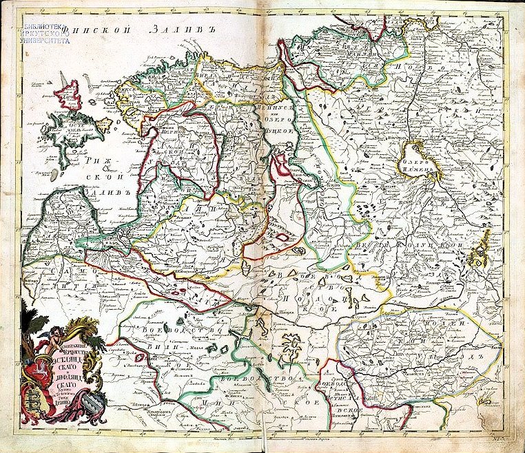
1745 Ivan Kirilov: the original, Cyrillic alphabet,
version of the de l'isle map to the left, titled:
"Изображение герцогствъ Эстляндскаго и
Лифляндскаго купно съ течениемъ реки Двины."
His planned three-volume "Atlas Vserossijskoj imperii"
was neither completed nor published in his lifetime
(1689-1737). The map on the left is from DSpace at the Univ. of
Tartu: http://dspace.utlib.ee/dspace/handle/10062/2891. The map
on the right is from www.karty.by

1740 Herman Moll:
"POLAND," London, 26 x
20 cm., from his "Atlas
Minor." Compare with
1732 version. From
www.jpmaps.co.uk
"POLAND," London, 26 x
20 cm., from his "Atlas
Minor." Compare with
1732 version. From
www.jpmaps.co.uk
1747 Johann Barnickel, Homann studio: "DVCATVS CVRLANDIÆ / juxta. Barnikelii Architecti Curici primarii Geometricam
Delineationem Geographica Tabula expressus studio Homannianor- um Heredum," Nuremberg, 518 x 815 mm. In the bottom
left corner the Lord’s Prayer is written in Latvian. Shown first, in the two maps at left, as a single map, including
"Semgalliae," and then as two separate maps, each with one or more DETAIL images. First all-in-one map is from www.raremaps.com;
second, and the Semgalliae map are from the National Library of Latvia: http://data.lnb.lv/nba05/kartes/frame_anglu.htm, via the European Library.
org. The separate Cvrlandiae map and detail images are from cesgia on eBay


1749 Johann Georg Schriebern: "Die Hertzoghümer Curland und Liefland,"
Leipzig, paper size 30.9 x 23.96 cm, in two versions from "Atlas Selectus von allen
Königreichen und Ländern der Welt, Zum bequemen Gebrauch in Schulen, auf
Reisen," first published in 1735. First map from the National Library of Latvia:
http://data.lnb.lv/nba05/kartes/frame_anglu.htm; second from www.oldtimesrarebooks.com


1748 Robert de Vaugondy: "ETATS DE
LA COURONE DE POLOGNE," 14 x 9.2
inches / 35 x 22 cm., as well as a
DETAIL image, from his "Atlas Portatif
Universel..." From claniz69 on eBay
LA COURONE DE POLOGNE," 14 x 9.2
inches / 35 x 22 cm., as well as a
DETAIL image, from his "Atlas Portatif
Universel..." From claniz69 on eBay

Johann Baptist Homann: "DVCATVVM LIVONIÆ ET
CVRLANDIÆ," Nuremberg, 19.25 x 22.875 inches, from
"Atlas Novus." 1747 version from odetowhitman on eBay; 1748
version from www.alexandremaps.com
CVRLANDIÆ," Nuremberg, 19.25 x 22.875 inches, from
"Atlas Novus." 1747 version from odetowhitman on eBay; 1748
version from www.alexandremaps.com

1740 Matthaus Seutter: "POLONIÆ REGNUM ut et
DUCAT. LITHUANIÆ," Augsburg, in two versions from
his "Atlas Minor." Compare with the 1744 and 1750
versions. First map from twinghiwin on eBay; second from
Biblioteca Virtual del Patrimonio Bibliográfico http://bvpb.mcu.es/
DUCAT. LITHUANIÆ," Augsburg, in two versions from
his "Atlas Minor." Compare with the 1744 and 1750
versions. First map from twinghiwin on eBay; second from
Biblioteca Virtual del Patrimonio Bibliográfico http://bvpb.mcu.es/

1742 1744 1744 1744 1747

1741 Nicolas Lenglet-Du
Fresnoy: "LE ROYAUME DE
POLOGNE AVEC SES
CONFINS," Venice, 5.5 by
7 inches, from " Methode
pour etudier la geo graph-
ie," published 1718 to
1755. From BeachMaps.com
Fresnoy: "LE ROYAUME DE
POLOGNE AVEC SES
CONFINS," Venice, 5.5 by
7 inches, from " Methode
pour etudier la geo graph-
ie," published 1718 to
1755. From BeachMaps.com


1744 Herman Moll: "POLAND.
Subdivided Into Its Several Palatinates
&c. Agreeable to Modern History,"
London, 10.3 x 8 inches. Thomas
Salmon's "Modern History: or the
Present State of All Nations." From
www.oldworldauctions.com
Subdivided Into Its Several Palatinates
&c. Agreeable to Modern History,"
London, 10.3 x 8 inches. Thomas
Salmon's "Modern History: or the
Present State of All Nations." From
www.oldworldauctions.com


1749 Gilles Robert de Vaugondy: "GRAND DUCHE DE LITHUANIE DIVISE par
Palatinats," Paris, 6.5 x 7.5 inches / 24 x 18.5 cm, in three versions from his "Atlas
Portatif, Universel et Militaire...," first published in 1748. First map from the Lithuanian
National Museum: www. lnm.lt; second map from odetowhitman on eBay; third from www.raremaps.com
Palatinats," Paris, 6.5 x 7.5 inches / 24 x 18.5 cm, in three versions from his "Atlas
Portatif, Universel et Militaire...," first published in 1748. First map from the Lithuanian
National Museum: www. lnm.lt; second map from odetowhitman on eBay; third from www.raremaps.com

1749 Jean Rousset de
Missy: "Les Estats de la
Couronne de Pologne,"
Amsterdam, image 7.7
x 6.5 inches, published
by Hendrik de Leth. From
theprintscollector on eBay
Missy: "Les Estats de la
Couronne de Pologne,"
Amsterdam, image 7.7
x 6.5 inches, published
by Hendrik de Leth. From
theprintscollector on eBay

c1740 Giovanni Albrizzi (publisher): "REGNO DI
POLONIA," Venice, 11.2 x 9.4 inches, in two versions
from "Atlante novissimo Che Contiene Tutte Le Parti
Del Mondo…." based on the work of de L’Isle. The map
of Poland is based on the work of Tirion. First map from
www.map-world.com; second from www.swaen.com
POLONIA," Venice, 11.2 x 9.4 inches, in two versions
from "Atlante novissimo Che Contiene Tutte Le Parti
Del Mondo…." based on the work of de L’Isle. The map
of Poland is based on the work of Tirion. First map from
www.map-world.com; second from www.swaen.com
1745 Guillaume De
L'Isle - Philippe Buache:
"La Pologne Dressee ..."
26 x 20 inches. Dated
1703, published 1745.
From www.raremaps.com
L'Isle - Philippe Buache:
"La Pologne Dressee ..."
26 x 20 inches. Dated
1703, published 1745.
From www.raremaps.com


1740 Gilles Robert de
Vaugondy: "GRAND
DUCHE DE LITHUANIE
...," Paris, plate 23.5 x
17.3 cm., from his "Atlas
Portatif." Compare with
the 1749 version. From the
collection of Algirdas Gustaitis,
offered by odisejas2007 on eBay
Vaugondy: "GRAND
DUCHE DE LITHUANIE
...," Paris, plate 23.5 x
17.3 cm., from his "Atlas
Portatif." Compare with
the 1749 version. From the
collection of Algirdas Gustaitis,
offered by odisejas2007 on eBay


c1745 George Louis le Rouge: "Le Royaume
De Pologne Le Grande Duche De Lithuanie
Suivant les Nouvelles Observations..."
Paris, 24.5 x 19.5 inches. From
www.raremaps.com
De Pologne Le Grande Duche De Lithuanie
Suivant les Nouvelles Observations..."
Paris, 24.5 x 19.5 inches. From
www.raremaps.com


1742 Denise Macquart
(engraver): "POLONIA,"
Venice, 6 x 8.5 inches,
published by Francesco
Pitteri. From
schilb_antiquarian_books
(engraver): "POLONIA,"
Venice, 6 x 8.5 inches,
published by Francesco
Pitteri. From
schilb_antiquarian_books
1740 1740 1745 1745

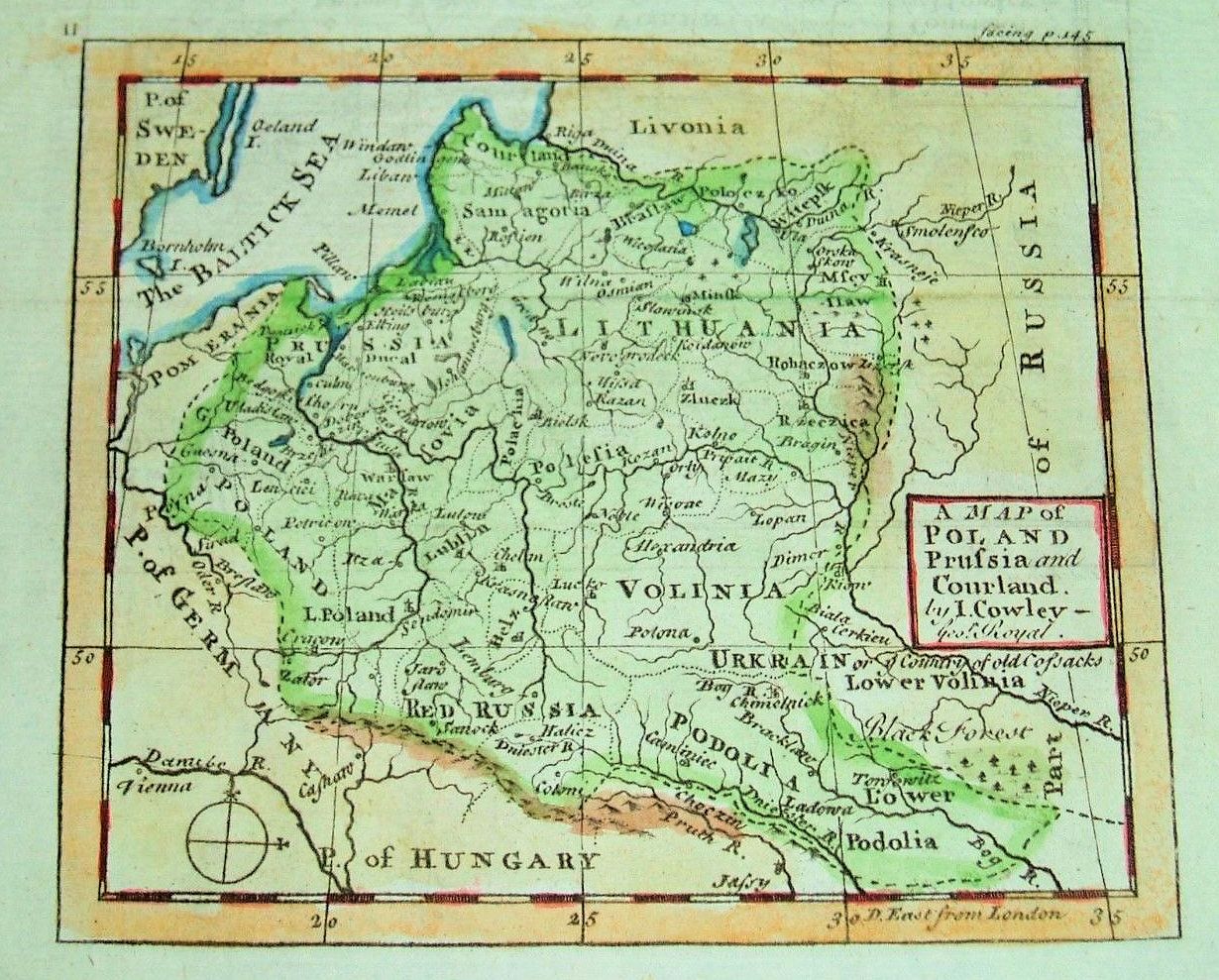

1742 John Cowley: "A Map of
POLAND, Prufia and Courland,"
London. Also a DETAIL image. From
cpd203 on eBay
POLAND, Prufia and Courland,"
London. Also a DETAIL image. From
cpd203 on eBay

1747 1748


1740 1742 1750


1744 Matthaus Seutter:
""POLONIÆ REGNUM UT
ET MAGNI DUCATUS
LITHUANIÆ," Augsburg,
in the third state. From the
National Library of Latvia:
http://academia.lndb.lv
""POLONIÆ REGNUM UT
ET MAGNI DUCATUS
LITHUANIÆ," Augsburg,
in the third state. From the
National Library of Latvia:
http://academia.lndb.lv


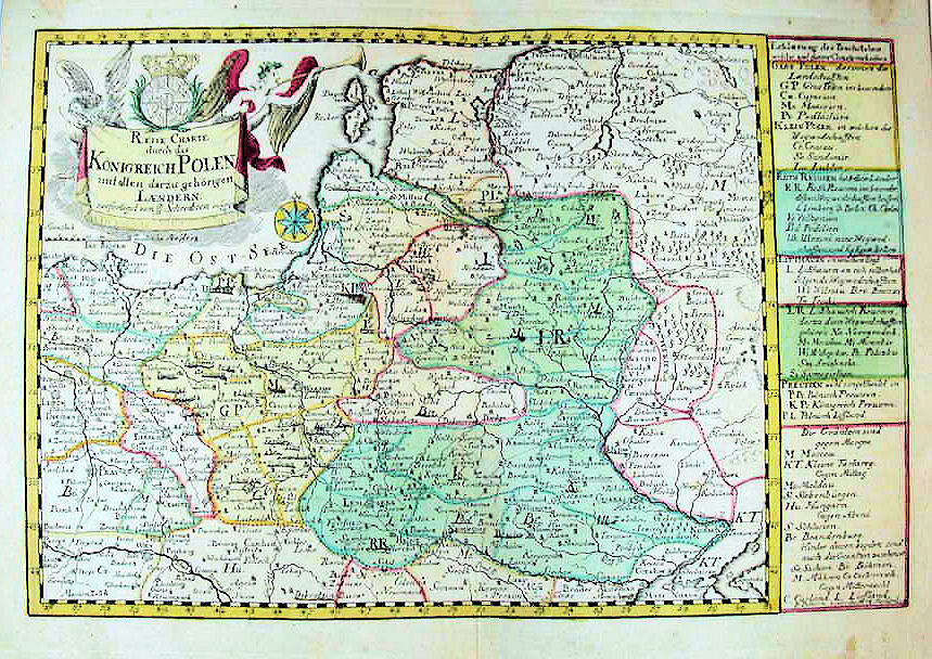
c1749 Johann Georg Schreiber: "Reise Charte durch das Königreich Polen mit allen darzu gehörigen Laendern,"
Leipyig, 7 x 10 inches, in three versions from "Atlas selectus von allem Künigreichen und Ländern der Welt," first
published 1735. Compare with 1730 and 1739 versions. First map from alteagallery.com; Second map and DETAIL images
from arlusatica on eBay
Leipyig, 7 x 10 inches, in three versions from "Atlas selectus von allem Künigreichen und Ländern der Welt," first
published 1735. Compare with 1730 and 1739 versions. First map from alteagallery.com; Second map and DETAIL images
from arlusatica on eBay


c1740 Giovanni Battista Albrizzi (publisher) - Isaa(c)k Tirion: "Nuova Carta del
Regno Di Polonia, Diviso nei suoi Palatinati, Secondo l'ultime offervazioni ed
anotazioni, fata in Amsterdam, per Isak Tirion" (New Map of the Kingdom Of Poland,
Divided into its Palatinates, according to the latest observations and annotations,
published in Amsterdam by Tirion"13 x 11 inches. First map from Altea Maps; 2nd & 3rd from
www.raremaps.com


1740 Schenk Family: "Estats de Pologne...",
Amsterdam, 22.8 x 18 inches, based on Sanson's work,
in two versions. First map from pbagalleries.com' second from
www.oldworldauctions.com
Amsterdam, 22.8 x 18 inches, based on Sanson's work,
in two versions. First map from pbagalleries.com' second from
www.oldworldauctions.com


| c1744 William Berry (mapmaker) - John Bowles (publisher): "Poland Subdivided According to the Extent of its Severall Palatinates," London, 34 x 21.5 inches, in an unrecorded third state of William Berry's 2 sheet map of Poland, first issued in about 1683, and based on Jaillot's earlier map. The first edition of Berry's map bears a dedication to Charles II, whereas Bowles has revised the dedication to the then present King, George II. This unrecorded third state with the imprint of John Bowles was issued circa 1744. The extremely rare second state of the map, bears the imprint of the partnership of Thomas Taylor, Philip Overton and John Lenthall. From www.raremaps.com |


1740 Isaac Tirion (pub-
lisher): "Nuova Carta del
Regno di Polonia Diviso
nei suoi Palatinati," Am-
sterdam. From LIETUVOS
DAILĖS FONDAS: ldfondas.
lt/en/collection
lisher): "Nuova Carta del
Regno di Polonia Diviso
nei suoi Palatinati," Am-
sterdam. From LIETUVOS
DAILĖS FONDAS: ldfondas.
lt/en/collection


1749 Jean Niepreckis
(engraver),corrected/
revised by Tobias Mayer,
published by Homann
Heirs: "Magni Dvcatvs
Litvaniæ..." Nürnberg,
19 x 24 inches. From The
Wroblewski Library of the
Lithuanian Academy of
Sciences: elibrary.mab.lt/
(engraver),corrected/
revised by Tobias Mayer,
published by Homann
Heirs: "Magni Dvcatvs
Litvaniæ..." Nürnberg,
19 x 24 inches. From The
Wroblewski Library of the
Lithuanian Academy of
Sciences: elibrary.mab.lt/
