Maps: 1761 - 1769

1761 Andrew Drury:
"POLAND," London.
"POLAND," London.

1762 Claude Buffier: "LA
POLOGNE," 5.5 x 7
inches. From the 1762
edition of his "Geographie
Universelle," first
published in 1715.
POLOGNE," 5.5 x 7
inches. From the 1762
edition of his "Geographie
Universelle," first
published in 1715.

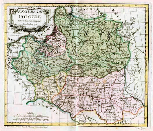
1762 Gilles Robert de
Vaugondy: "LA
POLOGNE," 11 x 9 3/8
inches. From the Heritiage
Map Museum, PA (AK-16)
Vaugondy: "LA
POLOGNE," 11 x 9 3/8
inches. From the Heritiage
Map Museum, PA (AK-16)


1764 Thomas Jeffreys: "POLAND, LITHUANIA and PRUSSIA," London, 9.5 x 7.5
inches. In an uncolored and two differently-colored versions. From various printings
of Salmon's "New Geographical and Historical Grammar"
inches. In an uncolored and two differently-colored versions. From various printings
of Salmon's "New Geographical and Historical Grammar"

1765 Thomas Kitchin:
"POLAND LITHUANIA
and PRUSSIA..." 9 x 7.5
inches. Also a DETAIL
image.
"POLAND LITHUANIA
and PRUSSIA..." 9 x 7.5
inches. Also a DETAIL
image.
| 1766 Louis Brion de la Tour: "ETATS DE POLOGNE ET DE LITHUANIE...AVEC ROYAUME DE PRUSSE, ET LE DUCHE DE CURLANDE," in four different iterations published the same year. Also a DETAIL image of the fourth map's cartouche. |


1766 Louis Brion de la
Tour: "CARTE...DE LA
POLOGNE ...DEL' EMPIRE
OTTOMON..."
Tour: "CARTE...DE LA
POLOGNE ...DEL' EMPIRE
OTTOMON..."


1766 Thomas Jeffreys:
'POLAND, LITHUANIA
and PRUSSIA."
'POLAND, LITHUANIA
and PRUSSIA."

1767 Claude Buffier:
"POLONIA."
"POLONIA."

1767 Thomas Salmon:
"POLAND LITHUANIA and
PRUSSIA," Edinburgh, 7 x
8 inches, from "A New
Geographical and
Historical Grammar."
From
www.cartographicarts.com
"POLAND LITHUANIA and
PRUSSIA," Edinburgh, 7 x
8 inches, from "A New
Geographical and
Historical Grammar."
From
www.cartographicarts.com
1767 Robert de Vaugondy
- Charles Francois
Delamarche: "LE
ROYAUME DE POLOGNE,"
Paris, 19.625 x 24.75
inches. From theprintscollector
on eBay
- Charles Francois
Delamarche: "LE
ROYAUME DE POLOGNE,"
Paris, 19.625 x 24.75
inches. From theprintscollector
on eBay

1768 P.J.D.G. Faure:
"LA POLOGNE," Paris, 5
1/2 x 6 3/4 inches / 135
x 170 mm, after a plate
first engraved 1744.
"LA POLOGNE," Paris, 5
1/2 x 6 3/4 inches / 135
x 170 mm, after a plate
first engraved 1744.


1768 Emanuel Bowen (engraver) - P.Meijer (publisher):
“Nieuwe Kaart van POOLEN, PRUISSEN EN
LITTHAUWEN,” 7.6 x 8.5 inches, Antwerp. Dutch version of Bowen's map of
Poland, from Meijer's "Complete Atlas or Distinct View of the Known World." Also
two DETAIL images. AK-03.
“Nieuwe Kaart van POOLEN, PRUISSEN EN
LITTHAUWEN,” 7.6 x 8.5 inches, Antwerp. Dutch version of Bowen's map of
Poland, from Meijer's "Complete Atlas or Distinct View of the Known World." Also
two DETAIL images. AK-03.

1769 Thomas Salmon:
"POLAND LITHUANIA
and PRUSSIA."
"POLAND LITHUANIA
and PRUSSIA."

1769 Louis Brion de la
Tour: "ETATS DE
POLOGNE ET DE
LITHUANIE." Paris, 23.5
x 26.5 cm. From
www.putmap.com
Tour: "ETATS DE
POLOGNE ET DE
LITHUANIE." Paris, 23.5
x 26.5 cm. From
www.putmap.com

1764 Nicholas Bellin:
"CARTE DE LA MER
BALTIQUE," Paris, 15 x
12 inches. From
www.raremaps.com
"CARTE DE LA MER
BALTIQUE," Paris, 15 x
12 inches. From
www.raremaps.com

| 1764 Gilles Robert de Vaugondy: "POLOGNE," 6.5 x 6 inches, in two differently-colored versions, both from "...la Geographie," which used maps from de Vaugondy's octavo "Atlas Portatif." Both from Beach Antique Maps and Prints |


| 1762 Johann Baptist Homann: "DVCATVVM LIVONIAE et CVRLANDIAE," Nuremberg, from "Grosser Atlas Gantze Über die Welt." From the Univ. of Tartu, Estonia: http://dspace. utlib.ee/dspace/ |

| 1764 Claude Buffier: "LA POLOGNE Suvivant les degres de l' Academie des Sciences de Paris," Paris, 5.5 x 7 inches, from his Geographie Universelle. From Beach Antique Maps & Prints on eBay |


1765 Louis Brion de la Tour: "ETATS DE POLOGNE ET DE LITHUANIE...AVEC
ROYAUME DE PRUSSE, ET LE DUCHE DE CURLANDE," Paris, map 26 x 23.5 cm,
in a rare first edition, without the typographic frame seen in later editions,
published as an insert by Louis Charles Desnos. Also two DETAIL images. From
boughettiarte on eBay
ROYAUME DE PRUSSE, ET LE DUCHE DE CURLANDE," Paris, map 26 x 23.5 cm,
in a rare first edition, without the typographic frame seen in later editions,
published as an insert by Louis Charles Desnos. Also two DETAIL images. From
boughettiarte on eBay

1762 Tobin Conrad Lotter
(publisher) - Tobia Lobeck
(engraver): "POLONIAE REG-
NUM, Ducatusq. Magnae
Lithuaniae," Augsburg, 11 x
13 cm, from the miniature
atlas "Atlas Geograpghicus Portatilis, first published 1755, in two
versions. First map from www.miklianmaps.com; second from www.davidrumsey.com
(publisher) - Tobia Lobeck
(engraver): "POLONIAE REG-
NUM, Ducatusq. Magnae
Lithuaniae," Augsburg, 11 x
13 cm, from the miniature
atlas "Atlas Geograpghicus Portatilis, first published 1755, in two
versions. First map from www.miklianmaps.com; second from www.davidrumsey.com

1769 Maurille-Antoine
Moithey (publisher) - L.
Crepy (engraver): "LA
POLOGNE, COMPRE-
NANT LE ROYAUME DE
PRUSSE, LES DUCHES
DE LITHUANIE ET DE
CURLANDE...," Paris, 67
x 48 cm. From Bibliotheque
nationale de France:
www.gallica.bnf.fr
Moithey (publisher) - L.
Crepy (engraver): "LA
POLOGNE, COMPRE-
NANT LE ROYAUME DE
PRUSSE, LES DUCHES
DE LITHUANIE ET DE
CURLANDE...," Paris, 67
x 48 cm. From Bibliotheque
nationale de France:
www.gallica.bnf.fr


1762 Giovanni Antonio
Rizzi-Zannoni: "CARTE
GENERALE DE LA POLOGNE avec tous les Etats qui
en dependent," Paris, 18 x 12.5 inches, and included
as plate no. 19 in the first edition of Jean Lattre's
1762 issue of "Atlas Moderne." Compare with the
1760 version. From www.geographicus.com
Rizzi-Zannoni: "CARTE
GENERALE DE LA POLOGNE avec tous les Etats qui
en dependent," Paris, 18 x 12.5 inches, and included
as plate no. 19 in the first edition of Jean Lattre's
1762 issue of "Atlas Moderne." Compare with the
1760 version. From www.geographicus.com
