Maps: 1801 - 1815


1802 William Darton, Jr: "POLAND," 7 1/4 x 8 1/2 inches / 19.6 x 22.2 cm., from "Atlas to Walker's Geography," in five versions, and three different
fonts for "Poland." The first map lacks an explanation under the title explaining territories lost as a result of the Partitions, so was likely published in
the 1770's; the second and fourth examples show results of the Second, 1793 Partition, while the fifth map mentions the 1772, 1793 and "subsequent
partition," it depicts only the result of the first partition.
1803 William Faden (original
mapmaker) - Tab'hane-yi
Hümayun (secondary mapmaker):
"Poland, Lithuania and Prussia,"
from the Ottomon Turkish "Cedid
atlas tercümesi" ("New Atlas
Translation"), Istanbul, from the
first Muslim-published world atlas
based upon European geographic
knowledge and cartographic
methods. The Atlas is based on
Faden's "General Atlas of the Four
Grand Quarters of the World," a
copy of which was acquired by
Mahmud Raif Efendi when he was
a private secretary at the Ottoman
embassy in London. He contributed
the introductory text to the atlas.
From Library of Congress, Geography and
Map Division: https://www.loc.gov
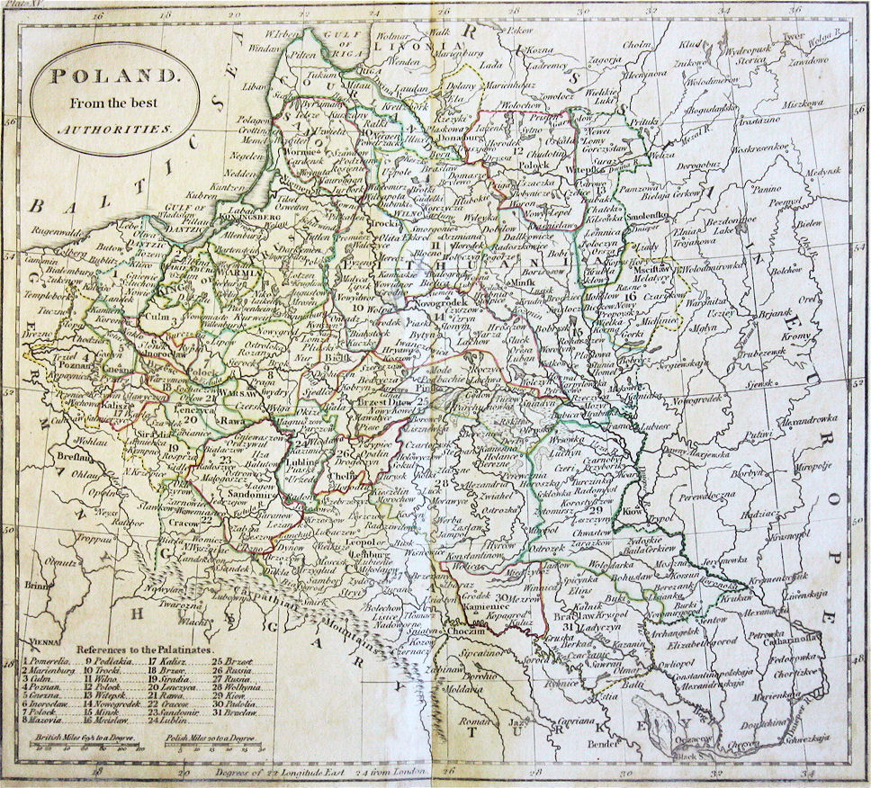
1805 Matthew Cary (cartographer) - William Guthrie (publisher): "POLAND. From the
best AUTHORITIES." London, 21 x 18 cm., in three versions from an Atlas to
"Guthrie's A New Geographical, Historical, and Commercial Grammar."
best AUTHORITIES." London, 21 x 18 cm., in three versions from an Atlas to
"Guthrie's A New Geographical, Historical, and Commercial Grammar."

1807 Claude Buffier: "LA POLONIA," and "LA RUSSIA
EUROPEA," Venice, each 21.6 x 17.5 cm, and
apparently from the same atlas. (The "Russia" map
confirms the "Our borders were once from the White Sea to
the Black sea," I heard from my mother growing up.)
EUROPEA," Venice, each 21.6 x 17.5 cm, and
apparently from the same atlas. (The "Russia" map
confirms the "Our borders were once from the White Sea to
the Black sea," I heard from my mother growing up.)


1809 John Barber -
William Guthrie:
"POLAND. Corrected &
Improved from the beft
AUTHORITIES."
William Guthrie:
"POLAND. Corrected &
Improved from the beft
AUTHORITIES."
1809-11 Samuel Neele (engraver) - James Cundee
(publisher): "Poland," London, 10 x 7.5 inches, in two
versions from "A New System of Geography and
Universal History," a variant (new maps by Neele) of
Guthrie's "Geographical Grammar."
(publisher): "Poland," London, 10 x 7.5 inches, in two
versions from "A New System of Geography and
Universal History," a variant (new maps by Neele) of
Guthrie's "Geographical Grammar."

1811 John Wallis (engraver) -
Samuel Augustus Oddy: "POLAND."
8 3/4 x 10 1/2 inches / 22 x 26 cm.
From "Oddy's New General Atlas of
the World..." Also a DETAIL image.
Samuel Augustus Oddy: "POLAND."
8 3/4 x 10 1/2 inches / 22 x 26 cm.
From "Oddy's New General Atlas of
the World..." Also a DETAIL image.

1812 Ezekiel Blomfield
(publisher) - James Barlow
(engraver): " POLAND.
Shewing the Claims of
RUSSIA, PRUSSIA and
AUSTRIA..." London. See
the 1806-07 versions. From
www.simonhunter.com
(publisher) - James Barlow
(engraver): " POLAND.
Shewing the Claims of
RUSSIA, PRUSSIA and
AUSTRIA..." London. See
the 1806-07 versions. From
www.simonhunter.com

1813 Charles Francois
Delamarche: "ROYAUME
DE POLOGNE," Paris, 29
x 27 cm. From "Nouvelle
Atlas Portatif...," Par
Robert de Vaugondy." It
was updated with new
findings by Delamarche.
This joint and updated
release is a key bridge of
18th and 19th century
mapmaking in France.
From www.miklianmaps.com
Delamarche: "ROYAUME
DE POLOGNE," Paris, 29
x 27 cm. From "Nouvelle
Atlas Portatif...," Par
Robert de Vaugondy." It
was updated with new
findings by Delamarche.
This joint and updated
release is a key bridge of
18th and 19th century
mapmaking in France.
From www.miklianmaps.com
1814 Robert Wilkinson (publisher) - Joshua
Archer (engraver): "POLAND," London, 9 x
11.5 inches, from his "General Atlas of the
World." See the 1808 and 1818 versions for
cmparison. From www.raremaps.com
Archer (engraver): "POLAND," London, 9 x
11.5 inches, from his "General Atlas of the
World." See the 1808 and 1818 versions for
cmparison. From www.raremaps.com


1809 Eustache Herisson
(publisher, pupil of
Rigobert Bonne) - C.B.
Glot (engraver): "LA
POLOGNE," 235 x 190
mm, Paris. From "Atlas
Portatif." From
www.ideararemaps.com
(publisher, pupil of
Rigobert Bonne) - C.B.
Glot (engraver): "LA
POLOGNE," 235 x 190
mm, Paris. From "Atlas
Portatif." From
www.ideararemaps.com
1814 C.V. Lavoisne (an American
cartographer, who worked with both Barfield
and Mathew Cary): "GEOGRAPHICAL AND
STATISTICAL MAP OF POLAND AND
HUNGARY," London, 21 x 17 inches / 52 x
42 cm. From Lavoisne's "Geographical
Atlas," published by Barfield. Also a DETAIL
image. From eBay, 2012
cartographer, who worked with both Barfield
and Mathew Cary): "GEOGRAPHICAL AND
STATISTICAL MAP OF POLAND AND
HUNGARY," London, 21 x 17 inches / 52 x
42 cm. From Lavoisne's "Geographical
Atlas," published by Barfield. Also a DETAIL
image. From eBay, 2012

1811 Thomas Dix:
"Poland," London,
14 x 17 cm., from
"Dix's Juvenile
Atlas." From
www.jpmaps.co.uk
"Poland," London,
14 x 17 cm., from
"Dix's Juvenile
Atlas." From
www.jpmaps.co.uk

1806 Charles Francois
Delamarche: "LA
POLOGNE avec ses
demenbremans." Paris,
20.5 x 22.5 cm. From Tim
Bryars at www.paralos.co.uk
Delamarche: "LA
POLOGNE avec ses
demenbremans." Paris,
20.5 x 22.5 cm. From Tim
Bryars at www.paralos.co.uk
1805 Luigi Rossi (publisher) -
Alexandre Blondeau (engraver): "LA
POLOGNEE AVEC LES PARTAGES
1772, 1793 et 1795," Paris, from
"Atlas universal pour la geographie
de Guthrie." Also a DETAIL image.
From www.swaen.com
Alexandre Blondeau (engraver): "LA
POLOGNEE AVEC LES PARTAGES
1772, 1793 et 1795," Paris, from
"Atlas universal pour la geographie
de Guthrie." Also a DETAIL image.
From www.swaen.com


1812 Gottlob Daniel Rey-
mann: "KARTE VON
ESTHLAND, LIVLAND,
CURLAND und SEMGAL-
LEN..,: Berlin. From
DSPACE at Univ. of Tartu: http:
//dspace.utlib.ee/dspace /
handle/10062/8555?show=full
mann: "KARTE VON
ESTHLAND, LIVLAND,
CURLAND und SEMGAL-
LEN..,: Berlin. From
DSPACE at Univ. of Tartu: http:
//dspace.utlib.ee/dspace /
handle/10062/8555?show=full

1812 "MAP of the
several Countries
throw which the
Russians are to pass
in their March to
PRUSSIA." From the
National Library of Latvia:
http://data.lnb.lv/
nba05/kartes/frame_
anglu.htm
several Countries
throw which the
Russians are to pass
in their March to
PRUSSIA." From the
National Library of Latvia:
http://data.lnb.lv/
nba05/kartes/frame_
anglu.htm

Charles Smith: "POLAND," London, 28 x 36 cm / 14 x
10.5 inches, from the first edition of "Smith's New
General Atlas Containing Distinct Maps Of all the
Principal Empires, Kingdoms & States Throughout the
World Carefully delineated from the best Authorities
extant," published through 1836.
10.5 inches, from the first edition of "Smith's New
General Atlas Containing Distinct Maps Of all the
Principal Empires, Kingdoms & States Throughout the
World Carefully delineated from the best Authorities
extant," published through 1836.

1810 Frances Bowen:
"Poland," a pen and ink
and watercolor manu-
script map, from her "A
General Atlas," created
by under the supervision
of her sister Eliza. From
www.davidrumsey.com
"Poland," a pen and ink
and watercolor manu-
script map, from her "A
General Atlas," created
by under the supervision
of her sister Eliza. From
www.davidrumsey.com
1815 [dated 1814] Lewis Hebert Senior (geographer/cartographer) - Samuel John Neele (engraver) - John Pinkerton (geographer/
archaeologist/historian): "POLAND" London, in a third version from "Pinkerton's Modern Atlas," one of the best English atlases of the time,
similar to Thomson's of 1817. Compare with the version from the 1818 Philadelphia edition.
archaeologist/historian): "POLAND" London, in a third version from "Pinkerton's Modern Atlas," one of the best English atlases of the time,
similar to Thomson's of 1817. Compare with the version from the 1818 Philadelphia edition.

1811 John Cary: "A NEW
MAP OF POLAND AND
THE GRAND DUCHY OF
LITHUANIA Shewing
their Dismemberments
...," London, 20 x 18
inches. From www.
raremaps.com
MAP OF POLAND AND
THE GRAND DUCHY OF
LITHUANIA Shewing
their Dismemberments
...," London, 20 x 18
inches. From www.
raremaps.com


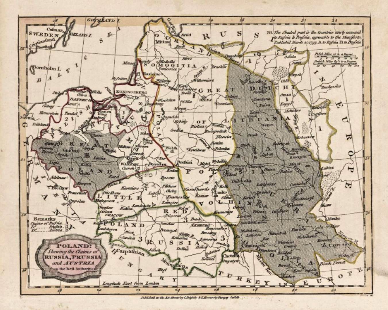
1804 or 1807 Rev. Ezekiel Blomfield (editor) - James Barlow (engraver): "POLAND: Shewing the Claims of Russia,
Prussia and Austria from the beft Authorities," Bungay, Suffolk, England, in four versions, published in either the
1804 or 1807 editions of "A General View of the World..." See the claimed 1812 version.
Prussia and Austria from the beft Authorities," Bungay, Suffolk, England, in four versions, published in either the
1804 or 1807 editions of "A General View of the World..." See the claimed 1812 version.

1804 Thomas Kitchin
(editor) - Laurie &
Whittle (publisher): "A
New Map of the Kingdom
of Poland..." London, 48 x
66 cm., from "Anew
Universal Atlas..." From
www.davidrumsey.com
(editor) - Laurie &
Whittle (publisher): "A
New Map of the Kingdom
of Poland..." London, 48 x
66 cm., from "Anew
Universal Atlas..." From
www.davidrumsey.com

"A New Map of POLAND, and the Grand Duchy of Lithuania, shewing their dismemberments and divisions between Austria, Russia and Prussia, in 1772, 1793 & 1795, from
the latest authorities," London, in six versions.
the latest authorities," London, in six versions.
1808 John Cary maps of Poland-Lithuania from "Cary's new universal atlas, containing distinct maps of all the principal states and kingdoms throughout the World." You will
see this map ascribed, on other sites and at various map sources, to 1799, the date on the map, but the atlas from which this map was taken says it is a first edition, and is dated
1808 on the spine. Best available information on all the editions of the atlas and dates on this map: 1808; 1811 (see below) -- a reissue of 1808 with no map changes other than
an 1811 date appearing on some maps; 1819 (see examples on next page) -- for which a third of the maps were changed; 1824 -- with no changes in 1819 maps except for the
date; 1828 -- same as 1824 except for date changes; and reissues in 1833, 1836, and 1844. The maps below were all published in 1808:
| www.davidrumsey.com |


1811 [dated 1799] William Faden: "A Map of the King-
dom of Poland and Grand Dutchy of Lithuania including
Samogitia and Curland, divided according to their
dismemberments, with the Kingdom of Prussia...2nd
Edition," London, 54 x 60 cm, dated 1799 on the map,
from his 1811 "General Atlas." The map is a reduced
version of Rizzi-Zannoni's 1772 24-sheet map.

1808 [dated] Robert Wilkinson: "Poland," London, 24 x 30 cm. From the 1809 edition
(previously issued in 1794 and 1802) of "A General Atlas, being A Collection of Maps
of the World And Quarters, the Principal Empires, Kingdoms &c. with their several
Provinces & other Subdivisions, Correctly Delineated." Additional editions were
published until his death in 1825. after which the plates were acquired by William
Darton, who then issued his own "General Atlas."

1814 Mathew Carey:
"POLAND," Philadelphia,
15 x 12.5 inches. This is
the second edition of the
first map of Poland
published in the US.
Only the title has been
revised -- shortened from
the first, 1811, edition,
above.. From
www.raremaps.com
"POLAND," Philadelphia,
15 x 12.5 inches. This is
the second edition of the
first map of Poland
published in the US.
Only the title has been
revised -- shortened from
the first, 1811, edition,
above.. From
www.raremaps.com

1811 Matthew Carey:
"POLAND, Shewing
the Claims of Russia,
Prussia & Austria, until
the late Depredations,
the extent of which
cannot as yet be
ascertained. W. Barker
Sculp. Engraved for
Carey's American
Edition of Guthrie's
Geography improved,"
Philadelphia, 32 x
37 cm. See the 1814
2nd edition, below.
From www.davidrumsey.com


1813 A.P.H. Nordmann: "Carte du ciderant ROYAUME de POLOGNE / "CARTE des
vormalignen ganzen Konigsreich Pohlen, nach seiner dermaligen Eintheilung Aus
denen Charten des Gilly, Liesganig, Mayer, Schroetter, und Textor, darm des
Atlases des Russisches Kayserthumus von General Suchtelen. Neu entworfen von
A.P.H. Nordman. Wien by Artaria and Compag." (Map in front of the entire Kingdom
of Poland, after its partition based on the surveys of Gilly, Liesganig, Mayer, Schroetter,
and Textor, based on the atlas of Imperial Russia of General Suchtelen. Newly designed
by A.P.H. Nordman. Vienna by Artaria and Co.) Dated 1813, at 1:900 000, in two
images, along with seven DETAIL images. From www.easteurotopo.org


1808 From the first pocket Russian atlas, containing maps of 54 provinces and
regions of the Russian empire, on 35 sheets. All from karty.by
regions of the Russian empire, on 35 sheets. All from karty.by

1801 Thomas Brown: "A New and
Accurate Map of Poland with its
dismem- berd Provinces..." Edin-
burgh, 293 x 343 mm., from his
"A General Atlas." From luschnoar on
eBay
Accurate Map of Poland with its
dismem- berd Provinces..." Edin-
burgh, 293 x 343 mm., from his
"A General Atlas." From luschnoar on
eBay


1812 Edme Mentelle: "Carte de la
Pologne: et de la partie de la Russie
d'Europe compris entre Vilna, Moscou
et St Petersbourg," Paris, 58.0 x 61.5
cm. published by Chez les Auteurs.
From www.polona.pl
Pologne: et de la partie de la Russie
d'Europe compris entre Vilna, Moscou
et St Petersbourg," Paris, 58.0 x 61.5
cm. published by Chez les Auteurs.
From www.polona.pl

1802 ("Atlas of Russia: The guberniyas of
Estonia, Livonia, Courland, Vitebsk and
Polotsk). From the National Library of Estonia:
http://dspace.utlib.ee/dspace
Estonia, Livonia, Courland, Vitebsk and
Polotsk). From the National Library of Estonia:
http://dspace.utlib.ee/dspace
1802 Antonio Zatta - Antonio
Remon- dini: "La Pologne divisée en
ses Palatinats Selon la dernier Condi
vision des trois Puisances Sovoire
l'Au- triche, la Russie, la Prusse,"
Venice, 49 x 65 cm, from an
uncompleted atlas project that
included maps from each publisher's
prior atlases: Remondini's "Atlas
Universelle" of 1782-84, and Zatta's
1796 "New Atlas." From
antiquariat-paulisch.de


1812 Johannes Walch: "Neue militair-
ische situations Karte von West-Rus
land," Augsburg, 56.5 x 46.5 cm.,
with outlines of Russian goberniyas.
Also a DETAIL image. From boughettiarte
on eBay
ische situations Karte von West-Rus
land," Augsburg, 56.5 x 46.5 cm.,
with outlines of Russian goberniyas.
Also a DETAIL image. From boughettiarte
on eBay

1807 Gilles Robert de Vaugondy
(mapmaker) - Charles François
Delamarche (publisher): "CARTE
GENERALE...POLOGNE,'" Paris,
from "Atlas Universel." From
boughettiarte on eBay
(mapmaker) - Charles François
Delamarche (publisher): "CARTE
GENERALE...POLOGNE,'" Paris,
from "Atlas Universel." From
boughettiarte on eBay


1810 William Darton (mapmaker) -
Walker (publisher): "Poland,"
London, 11 x 8 inches, in modern
color, from "An Atlas to Walker's
Geography." Compare with the
1802 versions on this page. From
artlusatica on eBay
Walker (publisher): "Poland,"
London, 11 x 8 inches, in modern
color, from "An Atlas to Walker's
Geography." Compare with the
1802 versions on this page. From
artlusatica on eBay


1811 William Darton
(publisher): "Poland &
Prussia, from the latest
authorities," London, 26
x 30 cm. at 1: 4 400
000. From
www.davidrumsey.com
(publisher): "Poland &
Prussia, from the latest
authorities," London, 26
x 30 cm. at 1: 4 400
000. From
www.davidrumsey.com


1802 Thomas Kitchin
(mapmaker) - T. Cadell
(publisher): "POLAND
with its Dismember'd
Provinces," London, from
"Travels into Poland..."
From the British Library via
europeana.eu
(mapmaker) - T. Cadell
(publisher): "POLAND
with its Dismember'd
Provinces," London, from
"Travels into Poland..."
From the British Library via
europeana.eu


1813 Johann Ernst Knittel (mapmaker) -
Friedrich Campe (publisher): "Neue
militairische Situations=und Post=Carte
von Polen und Preussen von I.E. Kinittel /
Nouvelle Carte militaire et routiere de la
Pologne et de la Prusse par I.E. Knittel,"
Nuremberg, 19.5 x 32.5 inches, depicting
Post and Military Roads in the region. From
www.raremaps.com


1815 Gennaro Bartoli (engraver): "Prussia e
Polonia, 1815," Naples, 43.2 x 29.2 cm,
showing pre-partition boundaries for the
Polish - Lithuanian Commonwealth,
without actually labeling any part of the
map "Lithuania" or "Grand Duchy." From
cesgia on eBay: Old Times Rare Antiquarian Book
and Maps Sellers
Polonia, 1815," Naples, 43.2 x 29.2 cm,
showing pre-partition boundaries for the
Polish - Lithuanian Commonwealth,
without actually labeling any part of the
map "Lithuania" or "Grand Duchy." From
cesgia on eBay: Old Times Rare Antiquarian Book
and Maps Sellers

1807 "Karte von Pohlen, König:
Preussen und den angrenzenden
Ländern...," 60 x 44 cm. From
odetowhitman on eBay
Preussen und den angrenzenden
Ländern...," 60 x 44 cm. From
odetowhitman on eBay

1807 Franz Anton Schrämbl: "Polen in
die dermaligen Besitzungen
eingetheilt..," Vienna, 99 x 85 cm wall
map. From mbc.malopolska.pl
die dermaligen Besitzungen
eingetheilt..," Vienna, 99 x 85 cm wall
map. From mbc.malopolska.pl

c. 1807 Pierre-Gilles Chan-
laire - Edme Mentelle
(cartographers): "Carte de
l'Ancien Royaume de
Pologne...," Paris, as a fold-
ing map. From
www.antiquariat@pahor.de
laire - Edme Mentelle
(cartographers): "Carte de
l'Ancien Royaume de
Pologne...," Paris, as a fold-
ing map. From
www.antiquariat@pahor.de

1804 Dávid Pethes:
"Lengyel Főld" (Polish
Land), Debrecen,
Hungary. From "New
School Atlas for the
Secondary Classes." From
University of Debrecen,
Hungary, via www.
theeuropeanlibrary.org
"Lengyel Főld" (Polish
Land), Debrecen,
Hungary. From "New
School Atlas for the
Secondary Classes." From
University of Debrecen,
Hungary, via www.
theeuropeanlibrary.org


1805 Franz Ludwig Güssefeld
(cartographer) - Homann Heirs
(publishers): "Charte von den
Herzogthümern Liefland und
Esthland..," in two images,
Nürnburg. From Eesti
Rahvusraamatukogu, via The
EuropeanLibrary.org
(cartographer) - Homann Heirs
(publishers): "Charte von den
Herzogthümern Liefland und
Esthland..," in two images,
Nürnburg. From Eesti
Rahvusraamatukogu, via The
EuropeanLibrary.org

| trilobitesuk on eBay |
| www.philaprintshop.com |
| www.miklianmaps.com |
| boughettiarte on eBay |
| antiquemapsprints on eBay |

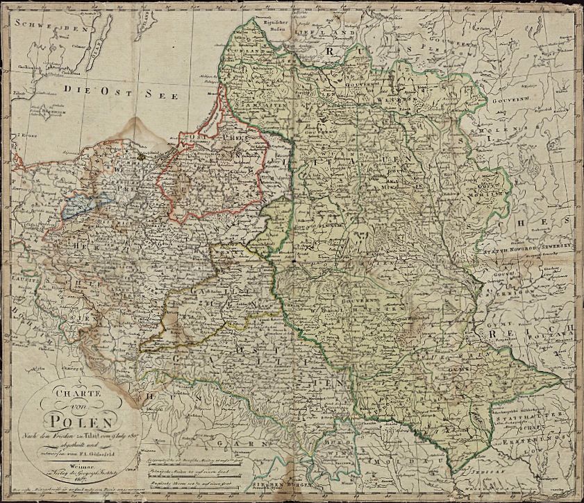
Franz Ludwig Güssefeld (mapmaker) - Geographisches
Institut Weimar (publisher): "Charte von Polen..,"
Nuremberg, 18 x 21 inches, in two versions published a
year apart depicting lands lost to Russia, Austria and
Prussia in the Three Partitions. The 1807 map has had
the legend on the bottom trimmed. See Güssefeld's 1797
version, titled "Charte des Königsreichs Polen."
| 1806 www.raremaps.com |
| 1807 www.europeana.eu from www.polona.pl |
| albion prints |
| www.oshermaps.org |
| www.alexandremaps.com |
| www.ritzlin.com |
| www.geographicus.com |
| www.raremaps.com |
| www.davidrumsey.com |
| www.raremaps.com |
| www.davidrumsey.com |
| www,raremaps.com |
| www.beachmaps.com |
| British Library, via wikimedia |
| "Губерния Виленская" Vilna g. |
| "Губерния Минская" Minsk g. |
| "Губерния Гродненская ц Губерния Волынская ц Губерния Белостокская" Grodno, Volhynian and Bialystok g's |

| www.raremaps.com |

1813 [dated] William
Faden: "A Map of the King-
dom of Poland and Grand
Dutchy of Lithuania...3rd
Edition," London, 22 x 24
inches. Originally pub-
lished with a different title
by Faden in 1799, and
based on the Rizzi-Zannoni
24-sheet map of 1772.
From www.raremaps.com
Faden: "A Map of the King-
dom of Poland and Grand
Dutchy of Lithuania...3rd
Edition," London, 22 x 24
inches. Originally pub-
lished with a different title
by Faden in 1799, and
based on the Rizzi-Zannoni
24-sheet map of 1772.
From www.raremaps.com
1813 Samuel John Neele (engraver/mapmaker): both
maps created to illustrate Sir Robert Ker Porter's
"Narrative of the Campaign in Russia during the year
1812." From U.S. Library of Congress: https://www.loc.gov
maps created to illustrate Sir Robert Ker Porter's
"Narrative of the Campaign in Russia during the year
1812." From U.S. Library of Congress: https://www.loc.gov


| "Advance of the French Army to Moscow" |
| "Retreat of the French Army from Moscow to the bank of the Neiman" |

| www.raremaps.com |

1807 [dated] Giovanni Antonio Rizzi-
Zannoni (cartographer) - Artaria & Co.
(publisher): "Polen in die dermaligen
Besitzungen eingetheilt..." From
www.raremaps.com
Zannoni (cartographer) - Artaria & Co.
(publisher): "Polen in die dermaligen
Besitzungen eingetheilt..." From
www.raremaps.com

| 1808 www.davidrumsey.com |
| 1809 www.raremaps/com |

1815 Leonard Chodźko (historian/
geographer/cartographer/publisher): "Das
Land der Polen vor seiner ersten Theilung
von1772 und im gegenwärtigen Stande
seit 1815. Mit Hinweisungen auf die
Zeitereignisse mit Angebung der
Ortsentfernungen u. Bezeichnung der
Landes u. Prov. Gränzen" (The land of
Poland before its first division of 1772 and
the present state since 1815. With allusions
to contemporary events with availing of
local distances and the names of the country
Provinces...), Freiburg im Breisgau, 17.5 x
22 inches. Tables include: regional
population statistics; table of battles for
political independence. At top right is a
map of Warsaw surrounded by Polish flags
and the words "To be or not to be," in
German. From www.raremaps.com

1806 [dated] Eustace Herisson (geo-
grapher/mapmaker/publisher): "Carte du
Royaume de Prusse, de la Pologne et de la
Lithuanie...Et ou l'on peut Suivre exact-
ement La Marche Des Armees Francaises"
Paris, 29.5 x 20 inches, depicting the area
at the time of the creation of the Duchy of
Warsaw by Napoleon. From
www.raremaps.com
grapher/mapmaker/publisher): "Carte du
Royaume de Prusse, de la Pologne et de la
Lithuanie...Et ou l'on peut Suivre exact-
ement La Marche Des Armees Francaises"
Paris, 29.5 x 20 inches, depicting the area
at the time of the creation of the Duchy of
Warsaw by Napoleon. From
www.raremaps.com
| www.davidrumsey.com |

| Harvard Map Library: www.harvard.edu |


1812 "Carte de la Russie
Européenne en LXXVII
feuilles exécutée au Depôt
general de la Guerre,"
ordered by Napoleon in
preparation for his invasion
of Russia. Shown are the
source map, the cartouche,
four individual maps and
three detail maps. From
Bibliotheque National de France:
www.gallica.bnf.fr
Européenne en LXXVII
feuilles exécutée au Depôt
general de la Guerre,"
ordered by Napoleon in
preparation for his invasion
of Russia. Shown are the
source map, the cartouche,
four individual maps and
three detail maps. From
Bibliotheque National de France:
www.gallica.bnf.fr
| A4 |
| A5 |
| A6 |
| A7 |
| Detail A6 |
| Detail A7 |


1813 [dated] Rigobert Bonne (original
mapmaker) - Eustace Hérisson (pupil of
Bonne/geographer): "Carte routière de la
Pologne , de la Lithuanie , de la Prusse et
d'une très grande partie de la Russie
d'Europe... où l'on peut suivre la marche
des armées françaises..," (Road map of
Poland, Lithuania, Prussia and a large part
of European Russia ... where you can
follow the march of the French armies...).
From Bibliotheque National de France:
www.gallica.bnf.fr

1812 John Pinkerton (geographer/carto-
grapher) - S & J Neele (engraver) - Cadell &
Davies (publisher): "Poland," Edinburgh, 28
x 20 inches, from "Pinkerton's Modern
Atlas," published 1808 - 1815, with an
American version by Dobson & Co. in
1818, on this site. From www.raremaps.com
grapher) - S & J Neele (engraver) - Cadell &
Davies (publisher): "Poland," Edinburgh, 28
x 20 inches, from "Pinkerton's Modern
Atlas," published 1808 - 1815, with an
American version by Dobson & Co. in
1818, on this site. From www.raremaps.com

Giovanni Valerio Pasquali (engraver): "LA POLONIA:
di nuova Projezione," Venice, 17.6 x 21.3 cm.
di nuova Projezione," Venice, 17.6 x 21.3 cm.
| 1807 [dated] "Geografia universale" Vilnius Univ. Library: www.atmintis.mb.vu.lt/ |
| 1810 [dated] "Nuovo Atlante Portatile" cesgia on eBay |


c. 1812 "Tableau des opér-
ations de la Grande Armée
depuis l'ouverture de la
campagne jusqu'au 21
aout 1812” (Table of
operations of the Grande
Armée since the opening of
the campaign until August
21, 1812). From Library of
Congress: www.loc.gov
ations de la Grande Armée
depuis l'ouverture de la
campagne jusqu'au 21
aout 1812” (Table of
operations of the Grande
Armée since the opening of
the campaign until August
21, 1812). From Library of
Congress: www.loc.gov

1807 ("Karta Guberni:...
Estlandskoi, Liflandskoi...
"), in Cyrillic, from
"Atlas of Russia." From
DSpace at the Univ. of Tartu:
http://dspace.utlib.ee/dspace/
Estlandskoi, Liflandskoi...
"), in Cyrillic, from
"Atlas of Russia." From
DSpace at the Univ. of Tartu:
http://dspace.utlib.ee/dspace/

| NEW June 21 |
| www.swaen.com |