Maps of Europe over time showing Lithuania(ns):
768 to 1942: By date depicted, not necessarily date created
This page is dedicated to those brave souls who continue to insist that the first
independent Lithuanian state was created in 1919.
768 to 1942: By date depicted, not necessarily date created
This page is dedicated to those brave souls who continue to insist that the first
independent Lithuanian state was created in 1919.

1000 "Baltic Lands." From
the 1903 "Atlas to Freeman's
Historical Geography"
the 1903 "Atlas to Freeman's
Historical Geography"

1220 "Baltic Lands." From
the 1903 "Atlas to Freeman's
Historical Geography"
the 1903 "Atlas to Freeman's
Historical Geography"

1270 "Baltic Lands." From
the 1903 "Atlas to Freeman's
Historical Geography"
the 1903 "Atlas to Freeman's
Historical Geography"
1350-60 "Baltic Lands."
From the 1903 "Atlas to
Freeman's Historical
Geography"
From the 1903 "Atlas to
Freeman's Historical
Geography"

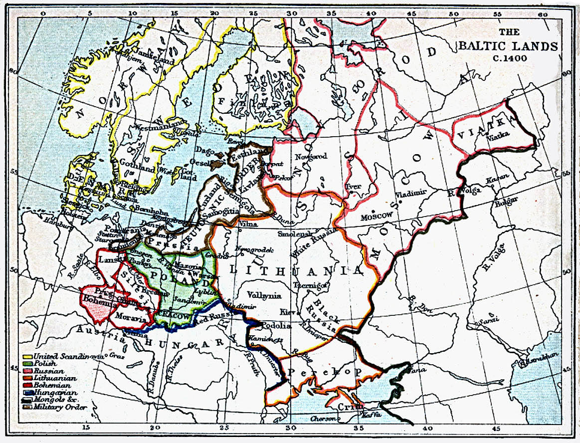
1400 "Baltic Lands." From
the 1903 "Atlas to Freeman's
Historical Geography"
the 1903 "Atlas to Freeman's
Historical Geography"

1478 "Baltic Lands." From
the 1903 "Atlas to Freeman's
Historical Geography"
the 1903 "Atlas to Freeman's
Historical Geography"

1563 "Baltic Lands." From
the 1903 "Atlas to Freeman's
Historical Geography"
the 1903 "Atlas to Freeman's
Historical Geography"

1617 "Baltic Lands." From
the 1903 "Atlas to Freeman's
Historical Geography"
the 1903 "Atlas to Freeman's
Historical Geography"
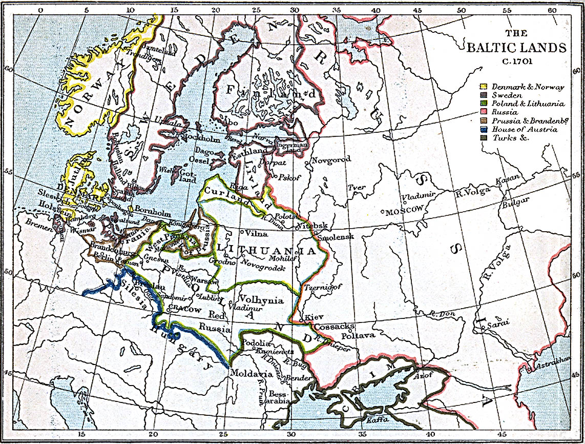
1701 "Baltic Lands." From
the 1903 "Atlas to Freeman's
Historical Geography"
the 1903 "Atlas to Freeman's
Historical Geography"

1772 "Baltic Lands." From
the 1903 "Atlas to Freeman's
Historical Geography"
the 1903 "Atlas to Freeman's
Historical Geography"

1795 "Baltic Lands." From
the 1903 "Atlas to Freeman's
Historical Geography"
the 1903 "Atlas to Freeman's
Historical Geography"
The history of the Balts by Marija Gimbutas

1015-1113:
"Kievan Rus"
"Kievan Rus"
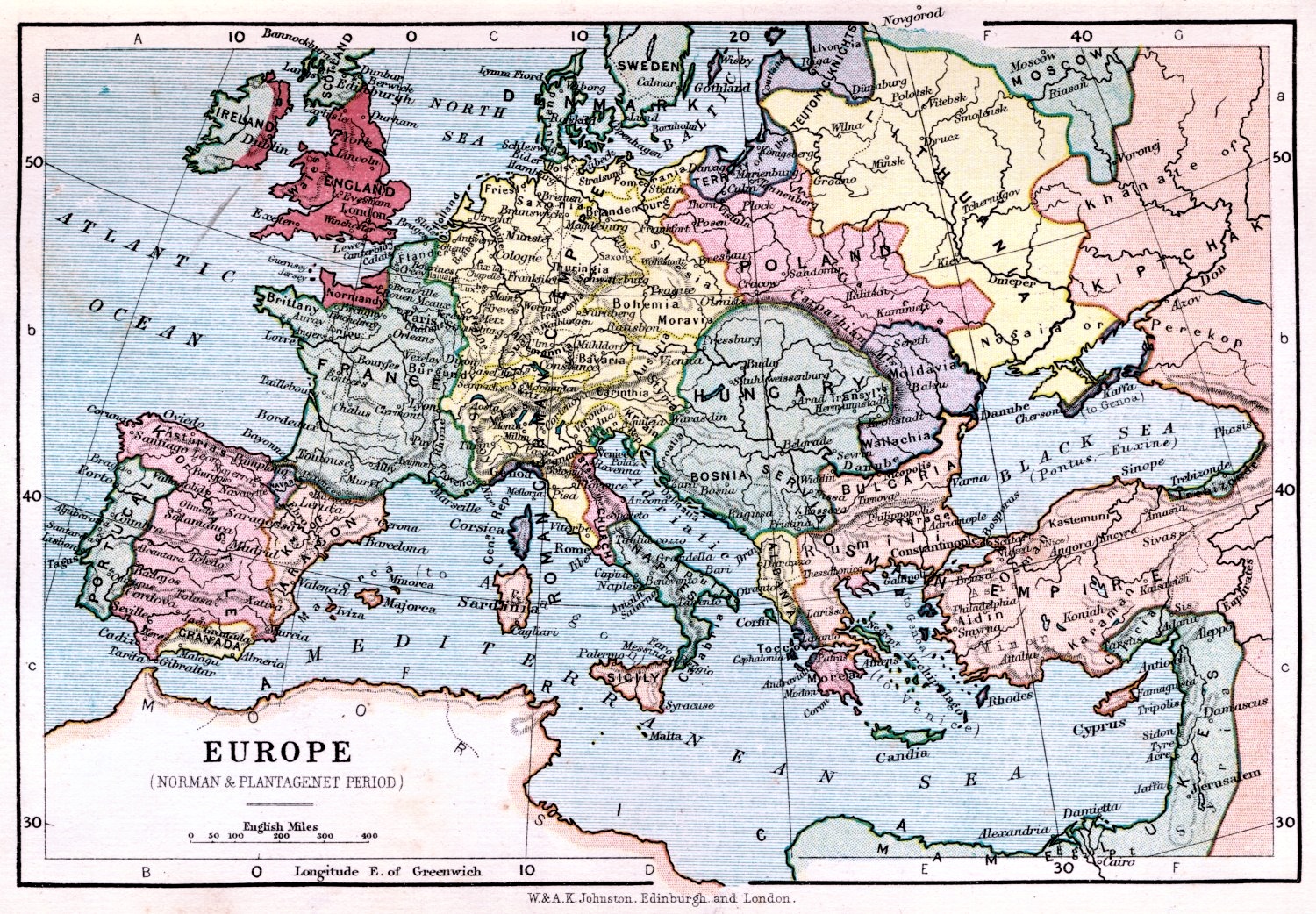
1066-1509 Johnston:
"Europe: Norman &
Plantagenet Period,"
1899. From etc.usf.edu/maps
"Europe: Norman &
Plantagenet Period,"
1899. From etc.usf.edu/maps

1095-1270 Victor Drury:
"Europe during the
Crusades, "from his 1912
"History of the World." From
www.etc.usf.edu/maps
"Europe during the
Crusades, "from his 1912
"History of the World." From
www.etc.usf.edu/maps


14th Century Karl vonnSpruner: "Nord-
und Ost-EUROPA im Anfange des XIVten
Jahrhunderts," from "von Spruner's School
Atlas," published by Gotha Justas Perthes
1860. From buybali on eBay
und Ost-EUROPA im Anfange des XIVten
Jahrhunderts," from "von Spruner's School
Atlas," published by Gotha Justas Perthes
1860. From buybali on eBay

17th Century to 1795
Spruner-Menke
Spruner-Menke
1809 "Baltic Lands." From
the 1903 "Atlas to Freeman's
Historical Geography"
the 1903 "Atlas to Freeman's
Historical Geography"
1914: "Russia in
Europe," from "An
Historical Atlas of
Modern Europe
from 1789 to
1922," Oxford
University Press,
1924.
Europe," from "An
Historical Atlas of
Modern Europe
from 1789 to
1922," Oxford
University Press,
1924.
Nov. 1942 - May 1945:
"Der Zweite Weltkreig in
Europe," showing Allied
advances against the
Germans.
"Der Zweite Weltkreig in
Europe," showing Allied
advances against the
Germans.


1689-1793: "RUSSIE
ET POLOGNE," from
Vidal- Lablache's
1912 "Atlas General
Histoire et
Geographie."
ET POLOGNE," from
Vidal- Lablache's
1912 "Atlas General
Histoire et
Geographie."


768-814 Spruner-Menke: ("Europe in the time
of Charlemagne"), from their "Hand-Atlas für
die Geschichte des Mittel-alters..." And a
DETAIL image. From www.maproom.org
of Charlemagne"), from their "Hand-Atlas für
die Geschichte des Mittel-alters..." And a
DETAIL image. From www.maproom.org

850-900 Spruner-
Menke: ("Slavs North of
the Danube"), from "Hand-
Atlas für die Geschichte
des Mittel-alters..." From
www.maproom.org
Menke: ("Slavs North of
the Danube"), from "Hand-
Atlas für die Geschichte
des Mittel-alters..." From
www.maproom.org

900-966 Spruner-Menke:
"RUSSLAND," from "Hand-
Atlas für die Geschichte des
Mittel-alters..." From
www.maproom.org
"RUSSLAND," from "Hand-
Atlas für die Geschichte des
Mittel-alters..." From
www.maproom.org

1000 "Europe and the
Byzantine Empire." From
http://www.lib.utexas.edu/pcl
Byzantine Empire." From
http://www.lib.utexas.edu/pcl


962 Spruner-Menke: ("Europe at the
Coronation of Otto I [as the Holy Roman
Empieror]), from "Hand- Atlas für die
Geschichte des Mittel-alters..." From
www.maproom.org
Coronation of Otto I [as the Holy Roman
Empieror]), from "Hand- Atlas für die
Geschichte des Mittel-alters..." From
www.maproom.org

966-1114 Spruner- Menke:
"RUSSLAND." From "Hand-
Atlas für die Geschichte
des Mittel-alters..." From
www.maproom.org
"RUSSLAND." From "Hand-
Atlas für die Geschichte
des Mittel-alters..." From
www.maproom.org


| 1114-1220 Spruner- Menke: "RUSSLAND." From "Hand- Atlas für die Geschichte des Mittel-alters ..." From www.maproom.org |


1190 Spruner- Menke: "EUROPA zur zeit des
Dritten Kreuzzuges" ("Europe at the time of
the Third Crusade") From "Hand-Atlas für die
Geschichte des Mittel-alters ..." From
www.maproom.org
Dritten Kreuzzuges" ("Europe at the time of
the Third Crusade") From "Hand-Atlas für die
Geschichte des Mittel-alters ..." From
www.maproom.org
| 1539 Olaus Magnus: "Carta marina," translated caption: "A marine map and Description of the Northern Lands and of their Marvels, most carefull drawn up at Venice in the year 1539." From the James Ford Bell Library, Univ. of Minnesota |


1350 Spruner- Menke: "EUROPA UM DIE
MITTE DES VIERZEHNTEN JAHRHUN-
DERTS" (Europe in the middle of the 14th
century) From "Hand-Atlas für die Geschichte
des Mittel-alters ..." From www.maproom.org
MITTE DES VIERZEHNTEN JAHRHUN-
DERTS" (Europe in the middle of the 14th
century) From "Hand-Atlas für die Geschichte
des Mittel-alters ..." From www.maproom.org


1492-1618 Spruner-Menke: "EUROPA
während des Zeit- raums der Reformation
und der Übermacht des Hauses Habsburg"
("Europe during the Reformation and the
supremacy of the House of Habsburg"), from
"Hand-Atlas für die Geschichte des
Mittel-alters ..." From www.maproom.org
während des Zeit- raums der Reformation
und der Übermacht des Hauses Habsburg"
("Europe during the Reformation and the
supremacy of the House of Habsburg"), from
"Hand-Atlas für die Geschichte des
Mittel-alters ..." From www.maproom.org

| 1570 and 1598 Sebastian Munster: "Europa Regina (Queen of theWorld)." For comparison, on the right is a 1598 version. First drawn by Jonannes Bucius in 1537, versions appeared in several editions of Munster's "Cosmography." Map on the left from www.raremps.com; map on the right from www.swaen.com" |


1581 Heinrich Bünting: "Die ganze Welt in
einem Kleberblat" (The Whole World in the
form of a Clover- leaf), Hanover, from his
"Itinerarium sacrae scripturae." From
www.karty.by
einem Kleberblat" (The Whole World in the
form of a Clover- leaf), Hanover, from his
"Itinerarium sacrae scripturae." From
www.karty.by
1593 Gerard de Jode: "SEPTENTRIONALIV REGIONIONVM SVETIAE GOTHIAE NOR-
VEGIAE DANIAE et terrarum adicetium recens exacta que descriptio per Liuinum
algoet Auctorem Gerardus de Jode execudebat," Antwerp, 19.5 x 14.5 inches. The Dutch
engravers were the famous Joannes and Lucas van Deutecum. First published 1578, De
Jode's "Speculum Orbis Terrae atlas was, while technically superior to the work of
Ortelius, a commercial failure, thanks to Ortelius' blocking a "privilege" for publication
for nearly ten years. This map is from the second, expanded edition of the atlas. Both from
www.raremaps.com


| 1595 Abraham Ortelius: "SEPTENTRIONALIUM REGIONUM DESCRIP.," Antwerp, 36 x 48.7 cm. First published 1570. Also a DETAIL image. From www.helmink.com |


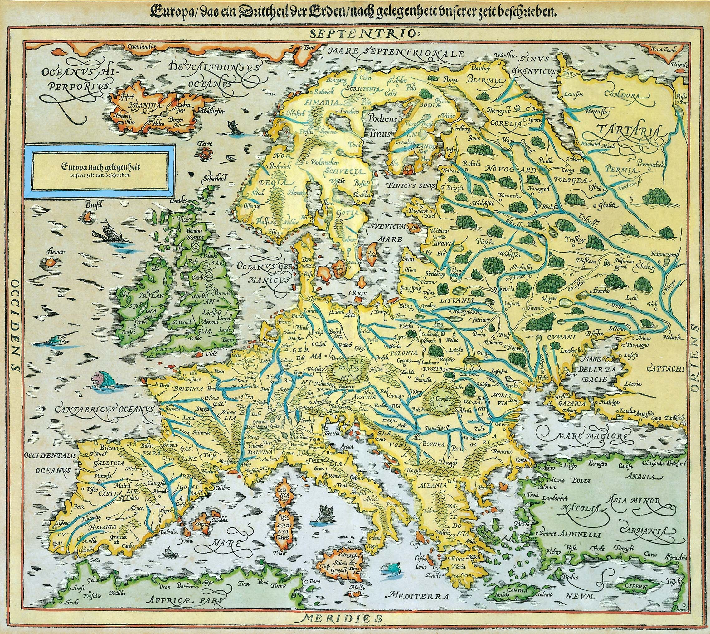
| 1628 Sebastian Munster: "Europa nach gelegenheit," from "Cosmographia, Das ist Beschreib- ung der ganzen Welt," Basel. From www.nic.funet.fi |
1650 Pierre Mariette: "LA
SCANDINAVIE ou sont les
Estats de SVEDE,
NORWEGVE et DANE-
MARCK," Paris, 21 x 17
inches. One of the earliest
maps of Scandinavia
published in Paris. From
www.raremaps.com
SCANDINAVIE ou sont les
Estats de SVEDE,
NORWEGVE et DANE-
MARCK," Paris, 21 x 17
inches. One of the earliest
maps of Scandinavia
published in Paris. From
www.raremaps.com


1670 Henricus Hondius:
"NOVISSIMA RUSSIAE
TABULA Authore Isaaco
Massa," London. From
the Moses Pitt "English
Atlas." From
www.raremaps.com
"NOVISSIMA RUSSIAE
TABULA Authore Isaaco
Massa," London. From
the Moses Pitt "English
Atlas." From
www.raremaps.com
1677 Pierre Duval:
"Moscovie dite autre-
ment Grande et Blanche
Russie," Paris, 20 x 15.5
inches. From
www.raremaps.com
"Moscovie dite autre-
ment Grande et Blanche
Russie," Paris, 20 x 15.5
inches. From
www.raremaps.com


| 1602 Abraham Ortelius: "RVSSIAE, MOSCOVIAE ET TARTARIAE DESCRIPTIO," Antwerp, 17.5 x 14 inches, engraved by Franz Hogenberg, based on Anthony Jenkinson's 1552 first-hand map of Russia. The vignettes illustrate Marco Polo's travels. From Ortelius' "Theatrum Orbis Terrarum." From www.raremaps.com |
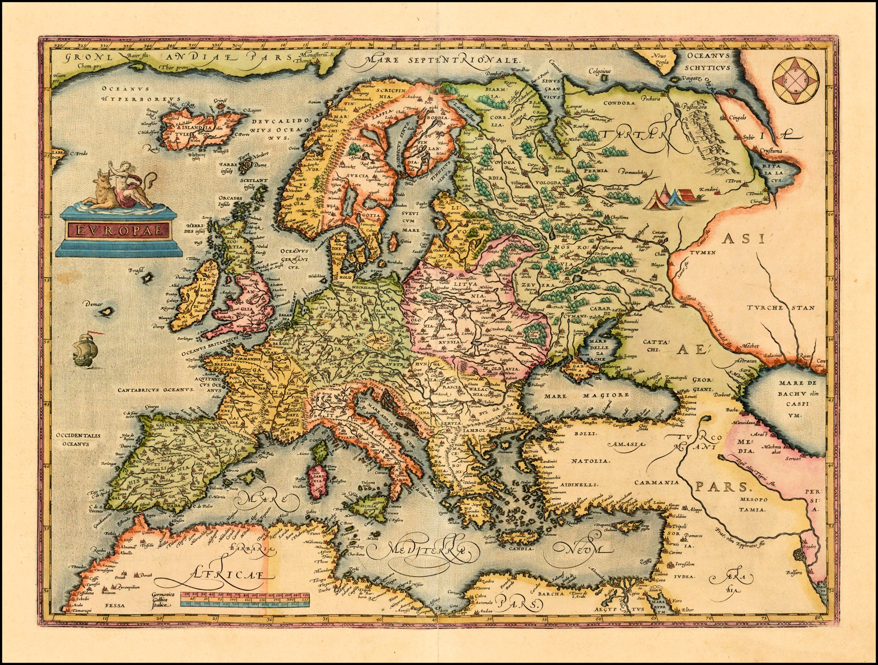
| 1603 Abraham Ortelius: "EVROPAE," Antwerp, 18 x 14 inches, from the second edition of Ortelius' map of Europe, first issued in 1584. and can be distinguished from earlier editions by the inclusion of cursive lettering in the the words "Africae Pars." From www.raremaps.com |

| c1630 Willem Janszoon Blaeu: "Europa recens descripta . . ." Amsterdam, 22 x 16 inches. The map shows nine European cities across the top and local costumes along the sides, including those of the "Poloni." From www.raremaps.com |

1581 Heinrich Bunting "EVROPA PRIMA
PARS TERRAE IN FORMA VIRGINIS ...
1548." Hanover, 17 x 12 inches, likely
published in 1581. From www.raremaps.com
PARS TERRAE IN FORMA VIRGINIS ...
1548." Hanover, 17 x 12 inches, likely
published in 1581. From www.raremaps.com
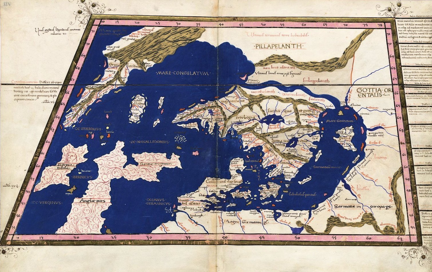
1467 Claudius Ptolemy:
From the first edition of
his "Geographia" with
maps -- engraved by
Taddeo Crivelli --
published in Bologna.
Note "Riga," and "Livonia."
From the first edition of
his "Geographia" with
maps -- engraved by
Taddeo Crivelli --
published in Bologna.
Note "Riga," and "Livonia."
| 1482 Francesco Nicolo di Berlinghieri: "TABVLA OCTAVA DE EUROPA," Florence, 22.5 x 17.5 inches, printed with two woodblocks on one sheet, in two versions from his "Septe Giornate della Geographia di Francesco Berlinghieri" (The Seven Days of Geography). Berlinghieri's map is the third map of the region (pre-dated by 1477 and 1478 editions, but his map is of the highest importance for several reasons: 1. It is based on the projections of Marinus of Tyre, a second century AD Greek geographer, cartographer and mathematician, credited as the founder of mathematical geography, a system which would have been employed by Claudius Ptolemy at the time Ptolemy originally constructed his "Geographia." 2. It is the first printed map of the region to utilize a style notably different from the Nicholas Germanicus model and to adopt a different means for projecting the printed landmasses represented on the maps. 3. It was engraved by Niccolò Tedesco, a German printer. 4. It has rectangular borders rather than the trapezoidal borders employed in the earlier editions. First map from Barry Lawrence Ruderman, www.raremaps.com; second fro m alteagallery.com |


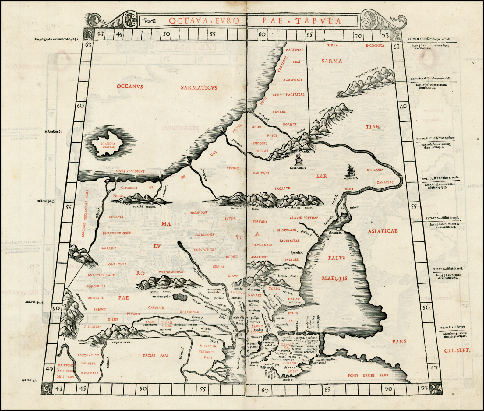
1490 Claudius Ptolemy: "Octava Evropae
Tabvla"
Tabvla"
| 1493 Hartman Schedel (Publisher)- Hieronymus Munzer (Editor)- Michael Wolgemut (Engraver): "Europa," from the "Nuremberg Chronicle," in colored and uncolored versions. Also a DETAIL image of the colored version, from: http://www.nada.kth.se/~ovidiu/maps/; the uncolored version is from www.bergbook.com |


1520 Abraham Ortelius: "TABVLA.
MODERNA.SARMATIE...POLONIE..." From the
National Museum of Lithuania.
MODERNA.SARMATIE...POLONIE..." From the
National Museum of Lithuania.

1535 Lorenz (Laurent) Fries: (Untitled),
Strassburg, 18 x 12 inches. from an
edition of Ptolemy's "Geographia"
published by Melchior and Gaspar
Trechsel. From www.raremaps.com
Strassburg, 18 x 12 inches. from an
edition of Ptolemy's "Geographia"
published by Melchior and Gaspar
Trechsel. From www.raremaps.com

| 1541 Lorenz (Laurent) Fries - Claudius Ptolemy - M. Servetius: "Tabula Nova Poloniae," Lyon. 12.09 x 14.29 inches. Servetius (Publisher) was tried by Calvin for heresy, and burned at the stake along with a number of his books. From www.alexandremaps.com |


1536 Martin
Waldseemuller:
"SARMATIA"
Waldseemuller:
"SARMATIA"


1540, 1542 Sebastian Munster: "EVROPA PRIMA NOVA TABVLA,"13.5 x 10 inches / 33 x
27 cm, Basle, in both the first, 1540 edition on the left, and the 1542 version on the right,
both woodcuts from his "Geographia," the first atlas to include maps of every continent. The
left, 1540, map is from jpmaps.co.uk; the right, 1542, map is from www.raremaps.com
27 cm, Basle, in both the first, 1540 edition on the left, and the 1542 version on the right,
both woodcuts from his "Geographia," the first atlas to include maps of every continent. The
left, 1540, map is from jpmaps.co.uk; the right, 1542, map is from www.raremaps.com
| Sebastian Munster: "TABVLA EVROPAE VIII," 10.9 x 13.3 inches, text in Latin, in from "Geographia Universalis, Vetus et Nova, complectens Cladii Ptolemaei Alexandrini enarrationis libros VIII" (first edition 1540), published by Heinrich Petri. Also a DETAIL images of the 1542 and 1545 maps compared. The same 21 words are listed in each version, but the list has been reset: 1542's "Badatiu" has become "Badatium" in the 1545 version 1542 map from www.sanderusmaps.com; 1545 map from lusarag on eBay |


1542 1545
1542 DETAIL


1545 DETAIL

1548 Giacomo Gastaldi:
"TABVLA EVROPAE VIII."
"TABVLA EVROPAE VIII."

1548 Johann Stumpf: (Europe), 15 x 12
inches, Zurich. Rare untitled variant
edition of Stumpf's map of Europe,
oriented with south at the top, from his
"Schweytzer Chronick." From
www.raremaps.com
inches, Zurich. Rare untitled variant
edition of Stumpf's map of Europe,
oriented with south at the top, from his
"Schweytzer Chronick." From
www.raremaps.com

1550 Giacomo Gastaldi: "Desciptione de la
Moscovia..." Venice, 15.5 x 10.5 inches,
based on the work of Baron Sigismund von
Herberstein, who had visited Moscow
twice as Emperor Maximillian I's
ambassador to Russia. From
www.raremaps.com
Moscovia..." Venice, 15.5 x 10.5 inches,
based on the work of Baron Sigismund von
Herberstein, who had visited Moscow
twice as Emperor Maximillian I's
ambassador to Russia. From
www.raremaps.com

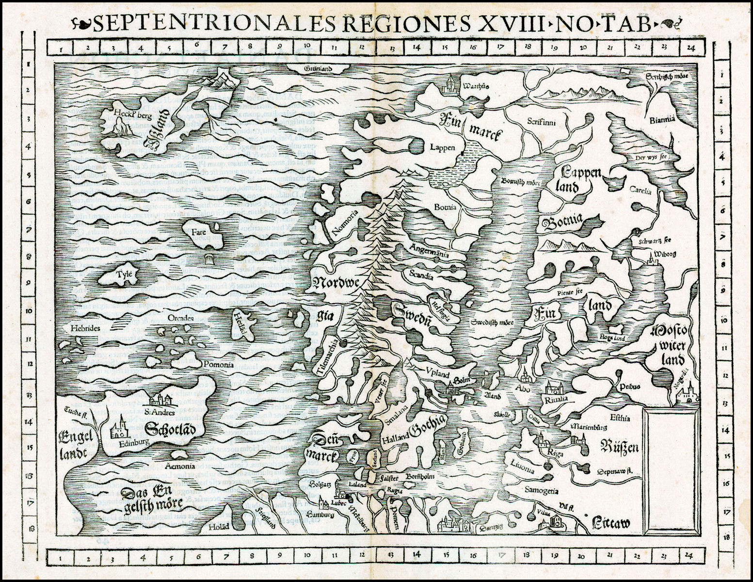
1552 Sebastian Munster: "SEPTENTRION-
ALES REGIONES XVIII NO TAB."
ALES REGIONES XVIII NO TAB."

1560, 1561 Girolamo Ruscelli: "EVROPAE TABVLA VIII,"
Venice, 10.5 by 7.5 inches, in two, differently-colored
versions, from editions of his "Ptolemaeus La Geografia."
Compare with 1574 versions below. First map is from Beach
Antique maps and Prints, on eBay
Venice, 10.5 by 7.5 inches, in two, differently-colored
versions, from editions of his "Ptolemaeus La Geografia."
Compare with 1574 versions below. First map is from Beach
Antique maps and Prints, on eBay


1574 Girolamo Ruscelli - Claudius Ptolemy: "EVROPAE
TABVLA VIII," Venice. 7.5 x 10.4 inches, in two
differently-colored versions, both from Ruscelli's
'Ptolemaeus La Geografia,' which published new
(Tabula Nova) maps along with Ptolemy's originals.
Both maps are from the 1574 edition of the atlas,
published by G. Ziletti. This Ptolemaic rendition of
central Europe is fairly recognisable to modern eyes
with an enlarged Sea of Azov dominat- ing the south
east. The western edge of the map is marked by the
Vistula river. Compare with the 1560 and 1561
versions. First map is from www.alexandremaps.com; second
map is from Beach Antique Maps and Prints (bertius) on eBay

1578 Gerard Mercator:
"Europa Octava tabula
EUR VIII TAB"
"Europa Octava tabula
EUR VIII TAB"

1597 Giovanni Antonio
Magini: "TABVLA
EVROPAE VIII." From an
early edition of Magini's
"Geographia," based
upon the work of
Ptolemy. From
www.raremaps.com
Magini: "TABVLA
EVROPAE VIII." From an
early edition of Magini's
"Geographia," based
upon the work of
Ptolemy. From
www.raremaps.com


| 1620 Claudius Ptolemy: "TAB.VIII. EUROPAE, in qua SARMATIA..." Also two DETAIL images. |


Willem Blaeu: "TABVLA RUSSIAE,"21 x 17.5 inches.
Engraved by Hessel Gerritsz in 1613, based on
information from Isaac Massa. Blaeu acquired the plate
after Gerritsz's death in 1632. Both maps from
www.raremaps.com
Engraved by Hessel Gerritsz in 1613, based on
information from Isaac Massa. Blaeu acquired the plate
after Gerritsz's death in 1632. Both maps from
www.raremaps.com
1630 1635
1640 Matthaus Merian: "TABULA RUSSIAE." in two
versions of Merian's edition of the Hessel Gerritsz map
of Russia -- with a radically different boundaries for
"LITTAW"! Compare also with the 1630 and 1635
Blaeu versions. Both from www.raremaps.com
versions of Merian's edition of the Hessel Gerritsz map
of Russia -- with a radically different boundaries for
"LITTAW"! Compare also with the 1630 and 1635
Blaeu versions. Both from www.raremaps.com


1689 Nicolas de Fer: "LA SUEDE
ET LA NORVEGE," paper 25.3 x
35.1 cm. Also a DETAIL image.
From www.oldtimesrarebooks.com
ET LA NORVEGE," paper 25.3 x
35.1 cm. Also a DETAIL image.
From www.oldtimesrarebooks.com

1697 Philipp Cluver:
"SVECIA, DANIA et
NORVEGIA," Leyden, 10
x 8.5 inches. Note that
Samogitia and Courland
are in East Prussia. From
www.raremaps.com
"SVECIA, DANIA et
NORVEGIA," Leyden, 10
x 8.5 inches. Note that
Samogitia and Courland
are in East Prussia. From
www.raremaps.com

1705 Nicolas de Fer:
"ESTATS DES COURONNES
DE DANNEMARK, SUEDE
ET POLOGNE fur la Mer Bal-
tique," Paris, 27.5 x 17.5
inches. Engraved by Van
Loon, first published 1700.
"ESTATS DES COURONNES
DE DANNEMARK, SUEDE
ET POLOGNE fur la Mer Bal-
tique," Paris, 27.5 x 17.5
inches. Engraved by Van
Loon, first published 1700.

1710 Frederick de Wit -
J.Renaud: "Totius
EUROPAE Littora."
J.Renaud: "Totius
EUROPAE Littora."


| 1714 Henri Chatelain: "Carte de la Partie Meridionale du Royaume de Suede Avec une Table des Provinces et des Villes Principales," Amsterdam, 50.9 x 43.2 cm., from "Atlas Historique." Two DETAIL images. From www.oldtimesrarebooks.com |

| 1730 Johann Homann: "SCANDINAVIA...," Nuremburg, 19 x 22 inches / 48.3 x 55.9 cm. The original engraving must have been done before 1715, when Homann was appointed Geographer to the King, because it lacks a "cum privilegio," the Emperor -bestowed copyright authority. The map was included in Homann Heirs' "Maior" and "Grosser" atlases. From www.geographicus.com |

1744 Rapin de Thoyras -
Nicholas Tindal: "A
corrrect CHART of the
BALTICK..." 19 x 15
inches, London. From
www.raremaps.com
Nicholas Tindal: "A
corrrect CHART of the
BALTICK..." 19 x 15
inches, London. From
www.raremaps.com


1795 (Anon.): ("A new map of the Russian
Empire, from the Baltic Sea to the Caspian
Sea, divided in administrative regions.")
52.25 by 42.25 inches, mounted on linen.
Also a DETAIL image. From
crouchrarebooks.com
Empire, from the Baltic Sea to the Caspian
Sea, divided in administrative regions.")
52.25 by 42.25 inches, mounted on linen.
Also a DETAIL image. From
crouchrarebooks.com

1800 Tranquillo
Mollo: "SCHWEDEN,
Daenemarck u
Norweegen," Vienna,
17.5 x 13 inches. From
www.raremaps.com
Mollo: "SCHWEDEN,
Daenemarck u
Norweegen," Vienna,
17.5 x 13 inches. From
www.raremaps.com
1850 Francesco
Costantino Marmocchi: "
MAR BALTICO," 13 x 11
inches, Florence. From
www.raremaps.com
Costantino Marmocchi: "
MAR BALTICO," 13 x 11
inches, Florence. From
www.raremaps.com

| 1851 John Tallis & Co. (Publisher) - John Rapkin (Engraver): "The Baltic Sea," London, 13 x 9.5 inches, from R. Montgomery Martin's "The Illustrated Atlas, And Modern History Of The World Geographical, Political, Commercial & Statistical," 1851. Rapkin's name and decorative vignettes appear on most Tallis & Co. maps. From www.raremaps.com |


1891 Stieler: "OST-
EUROPA No. 3." From
the 1888-91 eighth
edition, of "Hand-Atlas
über alle Theile der Erde
und über das Weltge-
bäude" (Handy atlas of
all parts of the world and
of the universe), . (See
the 1862 edition.) (AK)
EUROPA No. 3." From
the 1888-91 eighth
edition, of "Hand-Atlas
über alle Theile der Erde
und über das Weltge-
bäude" (Handy atlas of
all parts of the world and
of the universe), . (See
the 1862 edition.) (AK)
1893 W. & A.K. Johnston (publishers):
"BALTIC SEA," 12 x 9.5 inches / 31 x
24 cm, from their "World-Wide Atlas of
Modern Geography." From Montreal Maps.
"BALTIC SEA," 12 x 9.5 inches / 31 x
24 cm, from their "World-Wide Atlas of
Modern Geography." From Montreal Maps.


1908 "RUSSIA IN EUROPE," London, 21 x 13.5 inches / 54 x 34 cm, from
G.W. Bacon's "Bacon's Popular Atlas of the World." Three DETAIL images.
From Andrews Old Maps and Prints, eBay
G.W. Bacon's "Bacon's Popular Atlas of the World." Three DETAIL images.
From Andrews Old Maps and Prints, eBay


1908 Harmsworth Atlas:
"Central & South Russia." From
Federation of East European Family
History Societies: www.feefhs.org
"Central & South Russia." From
Federation of East European Family
History Societies: www.feefhs.org

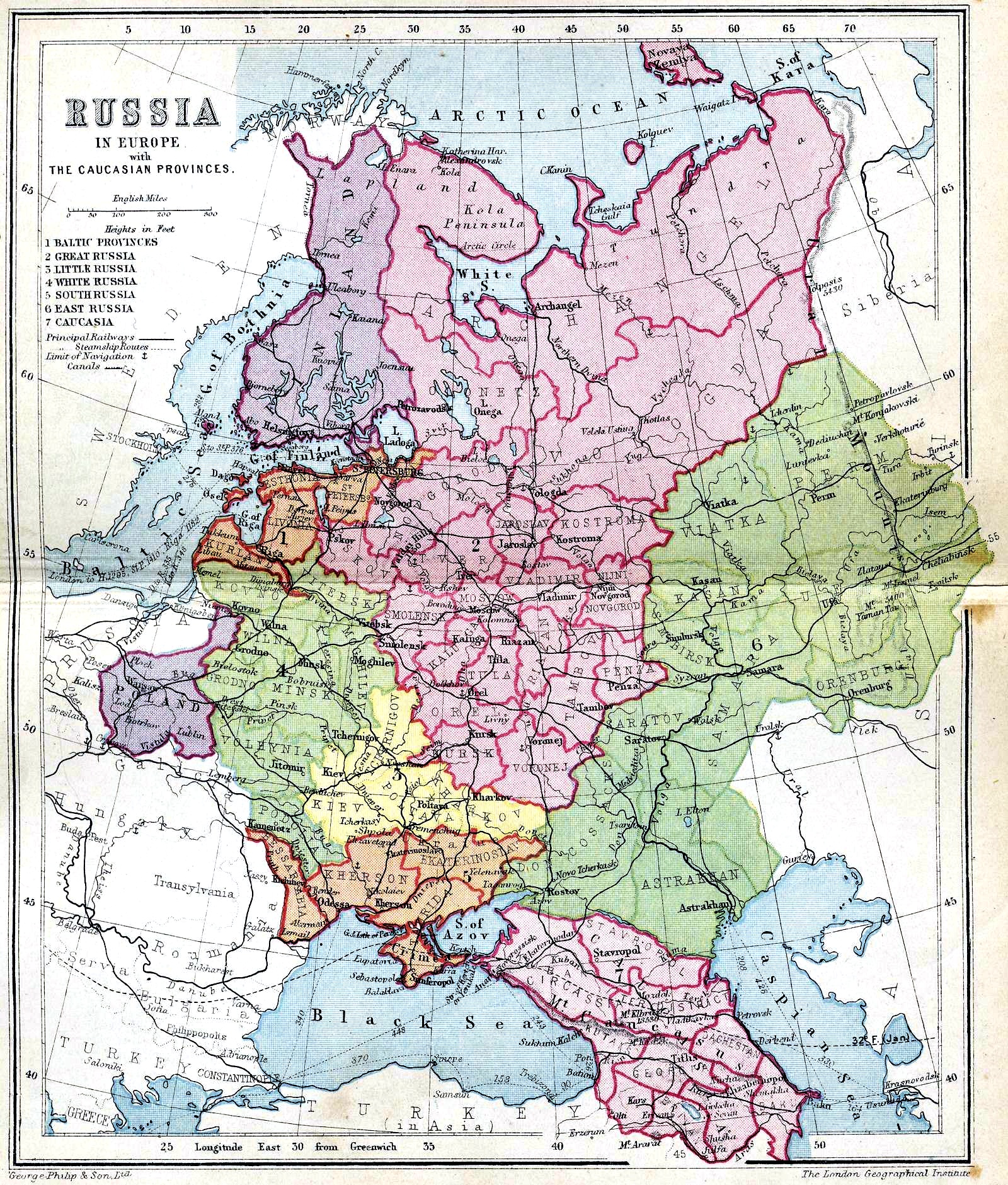
1911 The London Geographical
Institute: "RUSSIA IN EUROPE,"
published by George Philip & Son.
Institute: "RUSSIA IN EUROPE,"
published by George Philip & Son.
1916 "(Railway Map,
European Russia)" with a
detail inset of Lvov. From
www.karty.by
European Russia)" with a
detail inset of Lvov. From
www.karty.by

1917: "Germany's Future,"
according to an officially
published pamphlet -- with
annexed eastern territories
looking a lot like the old
Polish- Lithuanian
Commonwealth.
according to an officially
published pamphlet -- with
annexed eastern territories
looking a lot like the old
Polish- Lithuanian
Commonwealth.

1918 "Eastern Europe:
1914. Operations during
1918."
1914. Operations during
1918."

1918 The Graphic Magazine:
"RUSSIA DISMEMBERING
HERSELF"
"RUSSIA DISMEMBERING
HERSELF"

1920: "EUROPE," from "Leslie's
New World Atlas," 1920, NY.,
show- ing their guesstimate of
Post WWI boundaries. From
www.etc.usf.edu.maps
New World Atlas," 1920, NY.,
show- ing their guesstimate of
Post WWI boundaries. From
www.etc.usf.edu.maps


1919 "NOWA EUROPA W
ROKU 1919," Krakow-
Warszawa. Also a DETAIL
image. (AK)
ROKU 1919," Krakow-
Warszawa. Also a DETAIL
image. (AK)


1921 Hammond
Atlas: "RUSSIA,
POLAND, LITHU-
ANIA, LETVIA
ESTHONIA,
FINLAND." (AK)
Atlas: "RUSSIA,
POLAND, LITHU-
ANIA, LETVIA
ESTHONIA,
FINLAND." (AK)

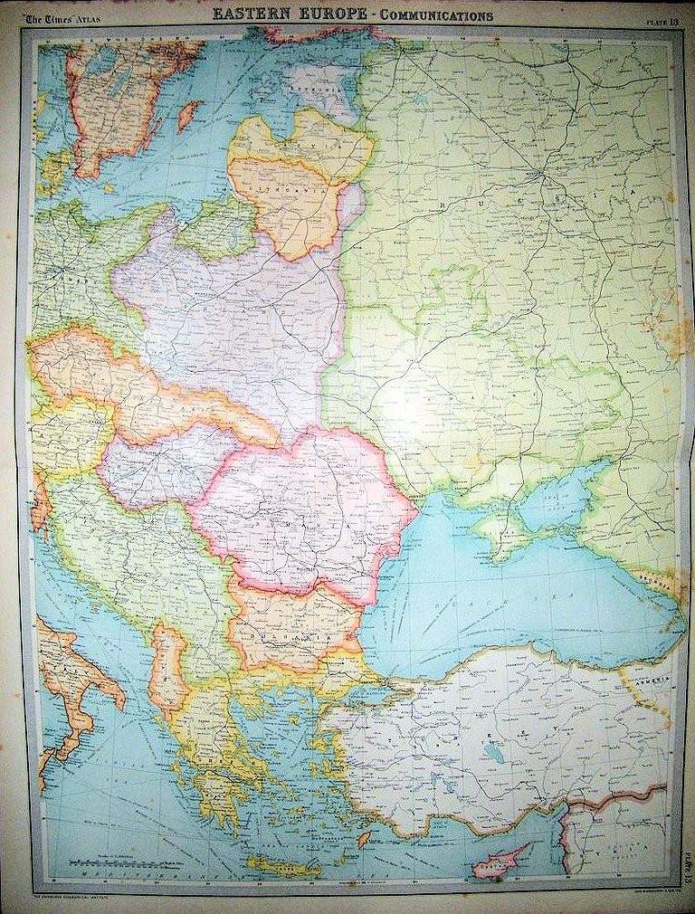
1921 "EASTERN EUROPE - COMMUNICA-
TIONS," from "The Times Survey Atlas of the
World," London. Also a DETAIL image. (AK)
TIONS," from "The Times Survey Atlas of the
World," London. Also a DETAIL image. (AK)

1922 George Philip: "THE
BALTIC SEA,"London. From
wwwdavidrumsey.com
BALTIC SEA,"London. From
wwwdavidrumsey.com


1646 John Speed:
"EUROPA," London, 5 x
3.5 inches, from his
scarce miniature atlas:
"Epitome." From
www.raremaps.com
"EUROPA," London, 5 x
3.5 inches, from his
scarce miniature atlas:
"Epitome." From
www.raremaps.com


| 1648- 1700 "EUROPA," from the 1880 Spruner- Menke Hand-Atlas. From www.maproom.org |

1643 Jean Boisseau:
"Nouvelle Description de
L'Europe, Paris, c1657
From Boisseau's Tresor des carte
Geographiques." From
www.raremaps.com
"Nouvelle Description de
L'Europe, Paris, c1657
From Boisseau's Tresor des carte
Geographiques." From
www.raremaps.com

1669 Willem Janzsoon
Blaeu - Giacomo
Giovanni RossiTotius
"Europae Nova Et Exacta
Tabula ...," Rome, 35 x
22.5 inches, in a
four-sheet map. From
www.raremaps.com
Blaeu - Giacomo
Giovanni RossiTotius
"Europae Nova Et Exacta
Tabula ...," Rome, 35 x
22.5 inches, in a
four-sheet map. From
www.raremaps.com
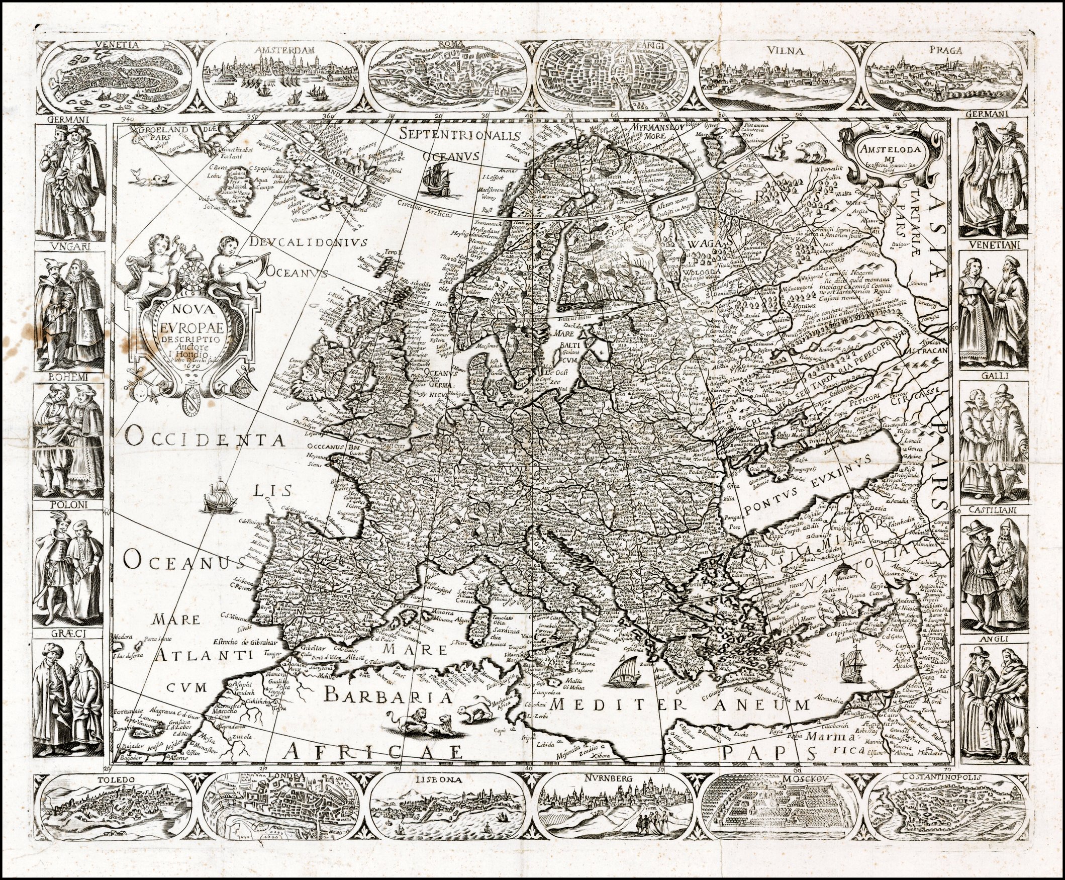
1670 Francesco Sabatini
- Pietro Todeschi: "Nova
Europae Descriptio
Auctore I. Hondio. Pietro
Todeschi Scul.," 21.5 x
17.5 inches, with 10 coty
views and 12 vignettes of
national dress. From
www.raremaps.com
- Pietro Todeschi: "Nova
Europae Descriptio
Auctore I. Hondio. Pietro
Todeschi Scul.," 21.5 x
17.5 inches, with 10 coty
views and 12 vignettes of
national dress. From
www.raremaps.com

1717 Nicolas de Fer:
"L'Europe Suivant les
Nouvelles Observations,"
Paris, 13 x 9 inches, in
the third state from his
"L'Atlas Curieux ou le
Monde." From
www.raremaps.com
"L'Europe Suivant les
Nouvelles Observations,"
Paris, 13 x 9 inches, in
the third state from his
"L'Atlas Curieux ou le
Monde." From
www.raremaps.com

1740 John Bartholomew:
"EUROPE," Edinburgh,
8.5 x 7 inch lithograph
from an 1896 atlas. From
york on eBay
"EUROPE," Edinburgh,
8.5 x 7 inch lithograph
from an 1896 atlas. From
york on eBay


"1740 EUROPA," from the 1880 Spruner- Menke
Hand-Atlas. With a DETAIL image. From
www.maproom.org
Hand-Atlas. With a DETAIL image. From
www.maproom.org


1810 "EUROPA zur Zeit NAPOLEON'S I," from
the 1880 Spruner-Menke Hand-Atlas. With a
DETAIL image. From www.maproom.org
the 1880 Spruner-Menke Hand-Atlas. With a
DETAIL image. From www.maproom.org


1815 "EUROPA nach dem Wiener Congress,"
from the 1880 Spruner- Menke Hand-Atlas.
With a DETAIL image. From
www.maproom.org
from the 1880 Spruner- Menke Hand-Atlas.
With a DETAIL image. From
www.maproom.org

c1865 P. van Bommel:
"EUROPISCH RUSLAN
EN POLEN," The
Netherlands, 8.3 x 10.2
inches, as an original
hand-drawn, colored,
manuscript map. From
theprintscollector on eBay
"EUROPISCH RUSLAN
EN POLEN," The
Netherlands, 8.3 x 10.2
inches, as an original
hand-drawn, colored,
manuscript map. From
theprintscollector on eBay

1765 A. van Krevelt:
"NIEUWE GENERALE
KAART VAN EUROPA,"
Amsterdam. From
www.orteliusmaps.org
"NIEUWE GENERALE
KAART VAN EUROPA,"
Amsterdam. From
www.orteliusmaps.org

1708 Charles Price
(cartographer) - John Senex
(engraver): "Europe
Corrected from the
Observations
Communicated to the Royal
Society at London," London,
37 x 22-inch two sheet
map. From www.raremaps.com
(cartographer) - John Senex
(engraver): "Europe
Corrected from the
Observations
Communicated to the Royal
Society at London," London,
37 x 22-inch two sheet
map. From www.raremaps.com

1919 "Europe," from the London
Geographical Institute, published 1920
in "The People's Atlas."
Geographical Institute, published 1920
in "The People's Atlas."


1893 "RUSSIA IN EUROPE," from "Blackie &
Sons, Edinburgh. Also a Atlas." DETAIL
image. AK
Sons, Edinburgh. Also a Atlas." DETAIL
image. AK

1598 Abraham
Ortelius: "EUROPA,"
Brescia, 5 x 4 inches,
from Marchetti's edition
of Ortelius' "Epitome."
From www.raremaps.com
Ortelius: "EUROPA,"
Brescia, 5 x 4 inches,
from Marchetti's edition
of Ortelius' "Epitome."
From www.raremaps.com
1740 Herman Moll:
"EUROPE," London, 8 x
10 inches, from his
"Atlas Minor, published
1729-40. From
jpmaps.co.uk
"EUROPE," London, 8 x
10 inches, from his
"Atlas Minor, published
1729-40. From
jpmaps.co.uk


1700 Pieter Schenk: "La
Scandinavie et les
Environs..." Amsterdam,
23 x 19 inches. From
www.raremaps.com
Scandinavie et les
Environs..." Amsterdam,
23 x 19 inches. From
www.raremaps.com
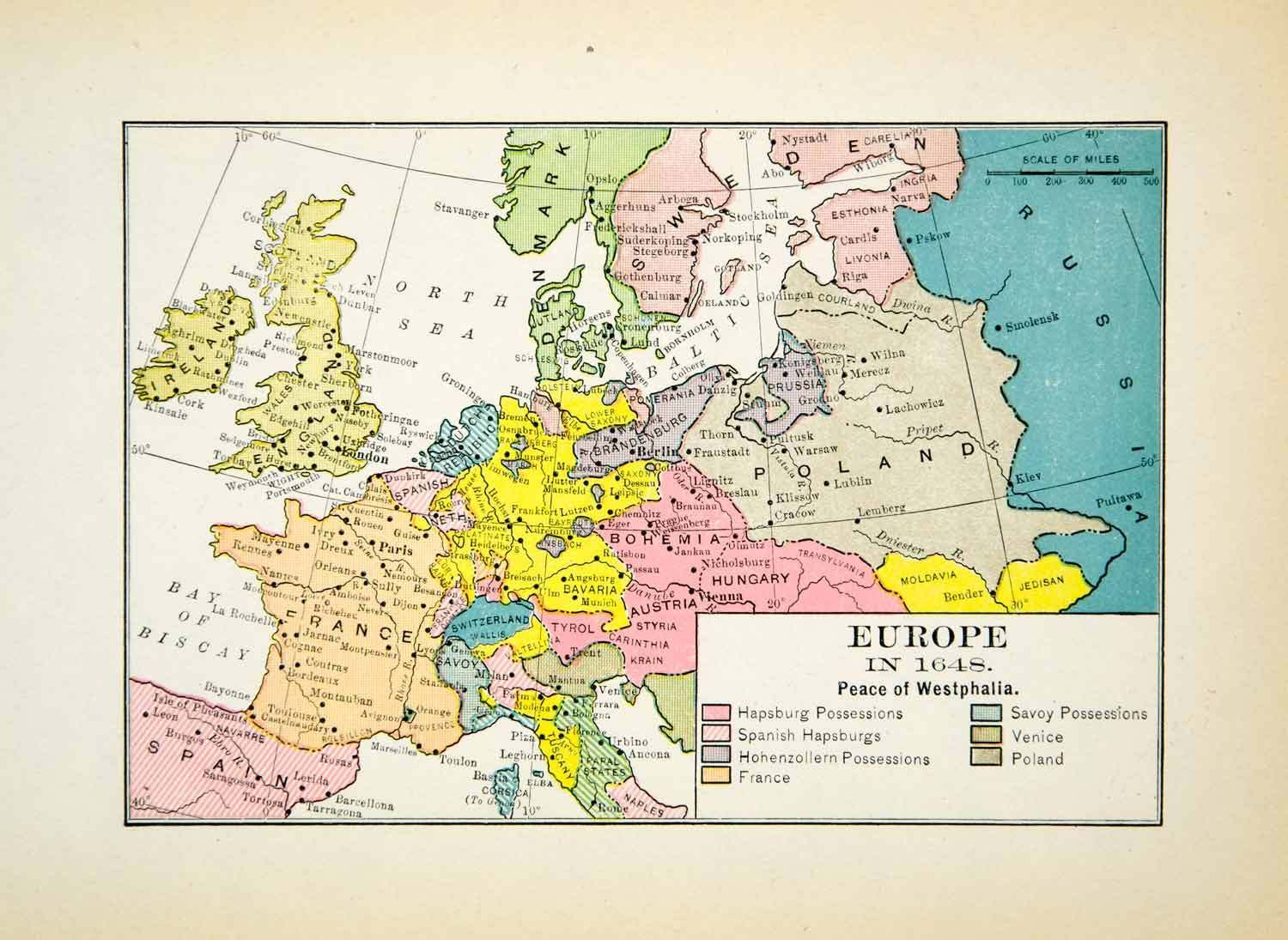
1648 (Anon.) "Europe;
the Peace of Westphalia,"
6.5 x 5 inches, published
1912. From
www.periodpaper.com
the Peace of Westphalia,"
6.5 x 5 inches, published
1912. From
www.periodpaper.com


814 "Europe at the Death
of Charles the Great,"
from 1905's "The Public
Schools Historical Atlas"
by Colbeck. From
www.lib.utexas.edu/maps
of Charles the Great,"
from 1905's "The Public
Schools Historical Atlas"
by Colbeck. From
www.lib.utexas.edu/maps
814 " "The Carolingian
and Byzantine Empires
and the Caliphate," from
Shepherd's 1926
"Historical Atlas."From
www.lib.utexas.edu/maps
and Byzantine Empires
and the Caliphate," from
Shepherd's 1926
"Historical Atlas."From
www.lib.utexas.edu/maps

William Shepherd: "The Peoples
of Europe about 900," from his
"Historical Atlas, 1911. From
http://www.lib.utexas.edu/maps
of Europe about 900," from his
"Historical Atlas, 1911. From
http://www.lib.utexas.edu/maps

1682 (Anon.) "North-
eastern Europe in the
time of Peter the Great,"
published 1907. From
www.periodpaper.com
eastern Europe in the
time of Peter the Great,"
published 1907. From
www.periodpaper.com

1891 "Europe," from
Rand McNally's "Indexed
Atlas of the World." From
the U.S. Librry of Congress,
Geography and Map Division.
Rand McNally's "Indexed
Atlas of the World." From
the U.S. Librry of Congress,
Geography and Map Division.

C. Colbeck: "Europe during the 15th Century," from the
1905 " Public Schools Historical Atlas." From
http://www.lib.utexas.edu/maps/historical/history_europe.htm
1905 " Public Schools Historical Atlas." From
http://www.lib.utexas.edu/maps/historical/history_europe.htm

1560 William Shepherd: "Europe," from his 1926
"Historical Atlas." From
http://www.lib.utexas.edu/maps/historical/history_europe.htm
"Historical Atlas." From
http://www.lib.utexas.edu/maps/historical/history_europe.htm

1713 Herman Moll:
"EUROPE after the
TREATY of UTRECHT,"
10 x 7.5 inches,
reprinted 1944. From
periodpaper
"EUROPE after the
TREATY of UTRECHT,"
10 x 7.5 inches,
reprinted 1944. From
periodpaper

c1700 Robin Redcoat:
"Europe." from WkiCommons
"Europe." from WkiCommons

William R. Shepherd:
"Europe about 1740," from
his 1926 "Historical Atlas."
From http://www.lib.utexas.edu/
maps/historical/history_europe
"Europe about 1740," from
his 1926 "Historical Atlas."
From http://www.lib.utexas.edu/
maps/historical/history_europe


| 1782 August Friedrich Wilhelm Crome: "NEUE CARTE VON EUROPA, (detailing Commercial and Industrial Production)," Netherlands, 20.3 x 17.3 inches. Tables list products made by each country, and a key at the bottom shows where those products originate. From www.oldworldauctions.com |

c1815 (Anon.): "EUROPA,"
Germany, 7 5/8 x 6 3/8.
From antiquemapsprints
Germany, 7 5/8 x 6 3/8.
From antiquemapsprints

1619 Gerard Mercator: "RVSSIA
cum Confinijs," Amsterdam, 14
x 19 inches, from his "Atlas Sive
Cosmographia." From
www.raremaps.com
cum Confinijs," Amsterdam, 14
x 19 inches, from his "Atlas Sive
Cosmographia." From
www.raremaps.com


1650-59 Nicolas Sanson: "l'EVROPE," Paris,
15.7 x 22.0 inches, published by Pierre
Mariette. Also a DETAIL image of "Pologne,"
and "Litvania." From www.swaen.com
15.7 x 22.0 inches, published by Pierre
Mariette. Also a DETAIL image of "Pologne,"
and "Litvania." From www.swaen.com

1640 Matthaus Merian: "EVROPA Nova
Delineatio," Frankfurt, 14 x 11 inches,
after Blaeu. From www.raremaps.com
Delineatio," Frankfurt, 14 x 11 inches,
after Blaeu. From www.raremaps.com

1922 London Geograph-
ical Institute: "Europe's
overland, sea commun-
ications," 50 x 70 cm., at
1:20 000 000, from the
"New Mercantile Marine
Atlas," by Hammond and
George Philip & Son. From
www.davidrumsey.com
ical Institute: "Europe's
overland, sea commun-
ications," 50 x 70 cm., at
1:20 000 000, from the
"New Mercantile Marine
Atlas," by Hammond and
George Philip & Son. From
www.davidrumsey.com

1922 J.G. Bartholomew: "Europe -
Political," London, 43 x 56 cm., at 1:10
000 000, published in "Times Survey
Atlas of the World." From
www.davidrumsey.com
Political," London, 43 x 56 cm., at 1:10
000 000, published in "Times Survey
Atlas of the World." From
www.davidrumsey.com

1619 Samuel Purchas - J
Jodocus Hondius:
"Europa...," London, 19 x
15 inches. From
www.raremaps.com
Jodocus Hondius:
"Europa...," London, 19 x
15 inches. From
www.raremaps.com

1676 John Speed: "A Map
of Russia," London, 20 x 16
inches, (drawn from Blaeu's
maps)from "Speed's Prospect
of The Most Famous Parts of
the World." From
www.raremaps.com
of Russia," London, 20 x 16
inches, (drawn from Blaeu's
maps)from "Speed's Prospect
of The Most Famous Parts of
the World." From
www.raremaps.com

1770 Thomas Kitchin:
"EUROPE from the best
Authorities," London.
From Modern Gazeteer
"EUROPE from the best
Authorities," London.
From Modern Gazeteer

1804 (dated 1795) Jean
Baptiste Bourguignon
d'Anville (cartographer) -
Thomas Kitchin (engraver)
- Robert Laurie & James
Whittle (publishers:
"Europe," London, 104 x
123 cm. at 1:4 800 000.
From www.davidrumsey.com
Baptiste Bourguignon
d'Anville (cartographer) -
Thomas Kitchin (engraver)
- Robert Laurie & James
Whittle (publishers:
"Europe," London, 104 x
123 cm. at 1:4 800 000.
From www.davidrumsey.com