Mapmakers of the Historic
Lithuanian Area: N - R
Lithuanian Area: N - R
Niepreckis (Nieprzecki), Jean, SJ: 1719 - 1754 Warsaw
Mathematics teacher and Jesuit, he was responsible for the 1749 map "Magnus Ducatus Lituaniae... delineatus," Nuremburg, for
Homann Heirs (which complemented Tomasz Makowski's 1613 "Carte du Grand Duche de Lituaniae..."). He also created the
1749 "Carte du Grand Duche de Lituaniae..." Nuremburg.
Mathematics teacher and Jesuit, he was responsible for the 1749 map "Magnus Ducatus Lituaniae... delineatus," Nuremburg, for
Homann Heirs (which complemented Tomasz Makowski's 1613 "Carte du Grand Duche de Lituaniae..."). He also created the
1749 "Carte du Grand Duche de Lituaniae..." Nuremburg.
Ortelius (Oertel, Ortel, Ortell, Wortels), Abraham: 1527-98. Born/died Antwerp
Began as a map colorist in 1547. Traveled throughout France and Italy with Gerard Mercator, whom he
described as a friend and rival. Appointed Royal Geographer to King Philip II of Spain in 1575. His best-known
work, "Theatrum Orbis Terrarum," was the first systematically collected set of maps by different mapmakers --
and is acknowledged as the first atlas. Editions of his maps continued to be published after his death, first by
Philippe Galle and his sons, with rights to the plates passing in 1601 to Jan Baptise Vrients.
Pograbski (Pograbius, Pograbka), Andrzej (Andreas Pilsnensis): died 1602
Polish physician and cartographer. His 1569 "Partis Sarmatiae Europeae quae Sigismundo Augusto Regi Poloniae Potentissimo
subiacet nova descripto," published in Venice, was used by Ortelius from 1595 onwards.
Polish physician and cartographer. His 1569 "Partis Sarmatiae Europeae quae Sigismundo Augusto Regi Poloniae Potentissimo
subiacet nova descripto," published in Venice, was used by Ortelius from 1595 onwards.
Greek astronomer, mathematician and geographer at the library at Alexandria,
Egypt. His "Almagest" was the most important work of Astronomy until the 16th
Century. The text for his "Geographia," composed c160, dominated the Christian
and Muslim worlds for a thousand years. The earliest surviving manuscript for it,
from the 12th century, was brought to Italy and translated into Latin by Jacopo
d'Angelos in 1406. The first printed edition, with no maps, came out in 1475. The
first edition with maps -- probably engraved by Taddeo Crivelli -- came out in
1477 in Bologna. The first edition outside Italy, the "Cosmographiae," was printed
in Ulm, in 1482 (The "Ulm Ptolemy"), by Lienhart Holle, with four contemporary
woodblock maps. Martin Waldseemuller's edition of 1513 added 20 new
maps. Gastaldi's miniature edition, Venice, 1548, had 60 maps. Mercator's
1578 edition had only the classical maps. Magini's 1596 edition had maps newly
engraved by G. Porro.

Ptolemy (Ptolemaicus, Ptolemeus, Tolomeo, Tolemius)
Claudius (Claude, Claudii, Claudio, Klaudios): c127 - 180
Claudius (Claude, Claudii, Claudio, Klaudios): c127 - 180
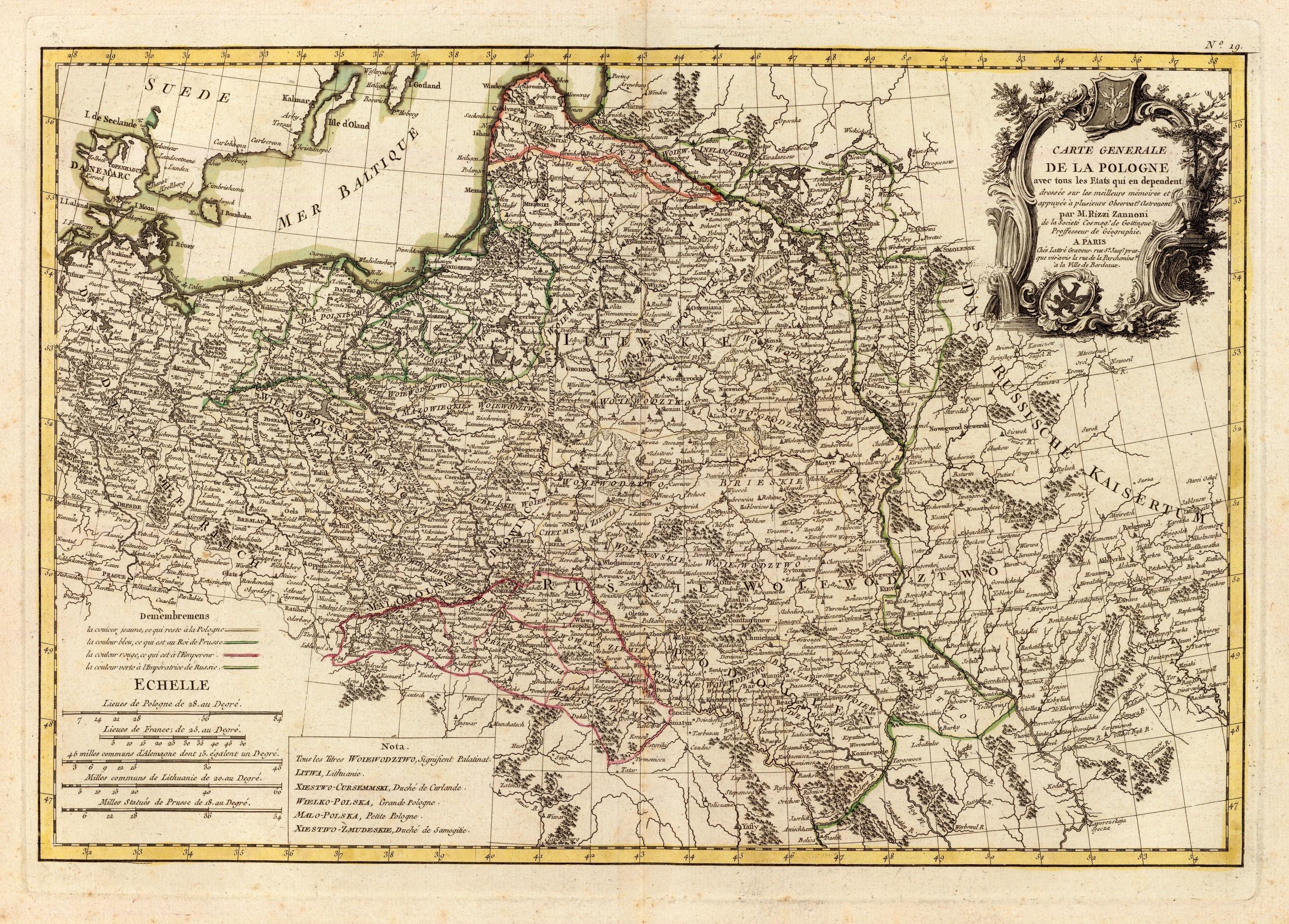
Geographer, astronomer. After traveling in Italy and abroad (visiting Turkey and Russia, among other countries),
he began his career as a cartographer in 1753 in Poland, where he had been summoned by King Augustus III. A
map of Poland he subsequently prepared was seen as far better than previous efforts. In 1756 he moved to
Sweden, where he was commissioned to map Danish possessions. In 1757 he went to Germany in the service of
Prussia, which was then involved in the Seven Years' War. During the Battle of Rossbach (Dec. 5, 1757), in which
the Prussians, led by Frederick the Great, prevailed over the French, he was taken prisoner and sent to Paris,
where he remained for over 20 years. While there, his output included J.T. Herissant and J. Lattre's 1762
"Atlas Moderne" with 36 maps, created with the help of Rigobert Bonne and J.D. Janvier; "Atlas
geographique et militaire," 1763, and "Carte Generale de la Pologne," in 25 sheets, 1772.

Rizzi-Zannoni, Giovanni Antonio: 1736 - 1814, born Padua, died Naples
Gilles Robert de Vaugondy (1688–1766), also known as Le Sieur or Monsieur
Robert, and his son, Didier Robert de Vaugondy (c.1723–1786), were leading
mapmakers in France during the 18th century. In 1757, they published “The
Atlas Universel,” one of the most important atlases of the 18th century. To
produce the atlas, the Robert de Vaugondys integrated older sources with
more modern surveyed maps. They verified and corrected the latitude and
longitude of many regional maps in the atlas with astronomical observations.
The older material was revised with the addition of many new place names.
Gilles was appointed "Geographe du roi" in 1734, while Didier was appointed
geographer to Louis XV in 1751. Gilles and Didier produced their 500+ maps
and terrestrial globes working together as father and son. In some cases it is
uncertain whether Gilles or Didier made a given map. Gilles often signed
maps as "M.Robert", while Didier commonly signed his maps as "Robert de
Vaugondy," or added "fils" or "filio" after his name. The Robert de
Vaugondys were descended from the Nicolas Sanson family through
Sanson's grandson, Pierre Moulard-Sanson; from him they inherited much
of Sanson's cartographic material, which they combined with maps and
plates acquired after Hubert Jaillot's death in 1712 to form the basis for the
"Atlas Universel." Like Ortelius and Mercator, the Robert de Vaugondys'
credited their sources, which has greatly benefited the study of the history
of cartography during that period. Their business was first taken over by
globe-maker Jean Fortin, in 1778, and then by Charles Francis Delamarche.
Their map "POLOGNE," dated 1750, was published in "Méthode abrégée et
facile pour apprendre la géographie," a French geographical school book for
children, first published in 1705 by Abbé Le François. He wrote the book for
his pupil Marie Anne Crozat, daughter of Antoine Crozat Marquis de Chatel,
a French banker. In the dedication to "Mademoiselle Crozat," signed with the
initials A.L.F., the author said that although his pupil, Miss Crozat, was
herself already too accomplished to really need the book, he was sure that
she would love to see her name mentioned. The book became very popular
and became known as "Géographie de Crozat." It was used in French
education for almost a century, going through many editions from about 1751
until well into the 1800's. The editions in the 1700s all used Vaugondy maps,
often dated 1750, but issued into the 1780's. Later 18th century editions had
new maps engraved but followed the Robert de Vaugondy outdated
geography.
Robert de Vaugondy Family: Flourished 1731 - 1778, Paris


Ortelius aged about
50, by Philip Galle.
The text below
reads: "By looking,
Ortelius gave to
mortal beings the
world,/ by looking
at his face, Galle
gave them Ortelius."
50, by Philip Galle.
The text below
reads: "By looking,
Ortelius gave to
mortal beings the
world,/ by looking
at his face, Galle
gave them Ortelius."
Girolamo Ruscelli: c1504 - 1566, born in Viterbo, Italy, flourished
and died in Venice
Italian alchemist, physician and cartographer. The first edition of his Ptolemy
Geography was in Latin, while all later editions, through the 6th in 1598-99 were in
Italian. The new copper engraved maps were based on G. Gastaldi's edition of 1548.
Also known for writing a book which included medicinal uses for hemp:


(Translated into Englishe by Richard Androse, published 1569): TAke of the séedes and gréene leaues of
Hempe, & taking out the iuice, put thereof warme into the eares, and you shall sée the effect. Or else, take
the Gawle of a Bull, of clarified Hony, of eche lyke quantitie, and boyling it in an earthen vessell, meddle
it well togither, and reserue it in a Viall of Glasse, and when néede requireth, being a little warme, put
thereof with wooll into the eare, first cleansing the eare from filthe.
Niewiadomski (Neviadomski), Eligiusz Joseph: 1869 - 1923, Warsaw
Best known as the Polish painter, art critic, and right-wing activist (with ties to The National Democratic Party [Polish:
Stronnictwo Narodowo-Demokratyczne] founded in 1897 by avowed anti-Semite Roman Dmowski) who assassinated the first
President of the Polish Republic, Gabriel Narutowicz, after just five days in office, in December 1922. The National Democratic
Party claimed Narutowicz was elected by "...the Reds, Jews and Germans" rather than by Poles. He was tried and shot by a
firing squad. He was also a significant mapmaker of the historic Lithuanian area because of his publication of a series of Polish
historical atlases, "Atlas do dziejów Polski zawierający 13 mapek kolorowanych," beginning in 1899, with editions in 1908 and
1920, in which he promoted the historical significance of Poland, often at the expense of Lithuania.
Franz Johann Joseph von Reilly: 1766 - 1820. Born and died in Vienna
Art dealer, mapmaker, and publisher, in 1789 he started a project: "Schauplatz der fünf Theile der Welt nach und zu Anton
Friedrich Büschings grosser Erdbeschreibung" (Scene of the five parts of the world: including Anton Friedrich Büsching's
description of the earth), engravings by Ignaz Albrecht, publishing maps weekly until 1806, by which time 830 maps had
been produced -- but only of Europe, and including maps of Poland and Lithuania -- despite the overall title. He also published,
among other atlases, a "Schul Atlas" in 1791-92 with 42 maps, and "Grosser Deutcher Atlas," with 28 sheets, the first
completely Austrian-made world atlas, in 1794-96.
| 1749 From "AtlasPortatif, universel et militaire..." |
| c. 1761 From "Bureau de l'Atlas National." |


| c. 1762+ 2nd State Adding Polish mileage Cartographic and Geological Institute of Catalonia: http://cartotecadigital.icc.cat |
| 1780+ 4th State New cartouche, legend, "Hongrie" disappears www.davidrumsey.com |

| c. 1771+ 3rd State Adding "Suede," new "Mer Baltique" www.raremaps.com |
States of Rizzi- Zannoni's: "CARTE GENERALE DE LA POLOGNE..." -- between the 1762 First State and the 1804 last
state, "Suede" appeared, "Hongrie" disappeared, the mileage chart and legend changed, the shape of the cartouche changed,
and a date was added to the cartouche. What is consistent: page "No. 19" above the top right frame line.
state, "Suede" appeared, "Hongrie" disappeared, the mileage chart and legend changed, the shape of the cartouche changed,
and a date was added to the cartouche. What is consistent: page "No. 19" above the top right frame line.
Eugeniusz Romer: 1871 - 1954, born in Lwów/Lviv/Львів Ukaraine
(once part of the Polish-Lithuanian Commonwealth), died Kraków
Student of German geographer Albrecht Penck, and became his greatest rival; chair of
geography in Lwów starting in 1911; wrote and created maps for his 1916 "Geograficzno-
statystyczny atlas Polski." The 65 maps and 5 diagrams were created by him and his
collaborators: W. Semkowicz, J. Nowak, W. Szafer, S. Weigner, J. Rutkowski, K. Nitsch, and
B. Chodkiewicz. It includes maps showing physiograpy, administrative division, history of
the Polish territory, population, nationality, religion, agriculture, industry and transport.
The atlas was smuggled to the West and used by President Wilson's Inquiry group, and at
Paris in 1919. He mapped the east at Riga in 1921, founded a Cartographical Institute in the
1920s for political, geographic, geological and ethnic maps of Poland and Lithuania.
Commentary sourced from Steven Seegel's 2018 "Map Men"

| Dating Grodeckis (original cartographer) - Andrzej Pograbski (correcting cartographer) - Ortelius (publisher): "POLONIÆ, LITVANIÆ Q. DESCRIPTIO." Valid dates: 1595, 1598, 1601, 1602, 1603, 1606, 1608, 1609. Thank you to Dr. Marcel van den Broecke of http://www.orteliusmaps.com/ |


| 1598: Harvard Map Library |
| Vladimiro Valerio |

| 1762 1st State www.antique-maps.lt |

| 1804 [dated] 5th State New cartouche, legend makilize on eBay |