Maps: 1940 - 1945
c. 1942-43 Nazi maps recovered by the US. All images from www.wii-photos-maps.com

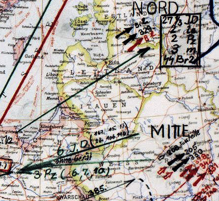
| 1942: Positions of Nazi units. |

| May, 1942: Nazi "Operation Blau." |


| September, 1943: Europe |

| Dec. 1943: "Ostland" |

| 1943 August |

| 1943 October |

| 1943 November |

| 1944 January |
"Brandenburg Division" troop locations:

| 1944 February |

| 1944 March |

| 1944 May |

1940 "Belorusskaya SSR," Leningrad, from the 11th
edition of "Pocket Atlas of the USSR," published by
"Chief Administration of Geodesy and Cartography
under the Council of People's Commissars of the USSR."
Adjacent parts of Poland are labeled "area of state
interests of Germany." On map on right: territories
annexed from occupied Poland colored yellow, and
considered "Western Belarus."

1940: "Estonskaya
SSR," published the
year of f its
establishment, July
21, 1940, following the
invasion of Soviet
troops on June 17,
1940 and the
installation of a puppet
govern- ment. The
Estonian SSR was
incorp- orated into the
USSR August 9, 1940
SSR," published the
year of f its
establishment, July
21, 1940, following the
invasion of Soviet
troops on June 17,
1940 and the
installation of a puppet
govern- ment. The
Estonian SSR was
incorp- orated into the
USSR August 9, 1940

1942 Jekab Jureviz; Gottfried Müller; Hermann Warren: "Ostland-Atlas: Baltische Randstaaten," published in Riga by Reichskommissar für das Ostland. One of two reports that make up
the "Strukturbericht über das Ostland" (Structural Report on the Ostland), the other being "Ostland in Zahlen" (Ostland in Numbers). This report was created by the Nazi Reich Commissioner
for the Eastern Territories and used in the civil administration of the occupied Eastern Territories: Estonia, Latvia, Lithuania, Belarussia and part of Poland. The 52 color maps show the
occupied administrative territories, its climate and vegetation, population demographics, agricultural status, industry, energy and economic features, traffic and roads, foreign trade in
1938, and the history of the area to 1943. Some representative maps are shown below. Maps by Ethnicity and religion are on the "Maps Ethnographic" page. From Ball State University's digital
library, at www.bsu.edu
| Administrative boundaries |
| Geology |

1940 "Litovskaya SSR"


1940 "Baltische Staaten..," Leipzig,
16 x 11 1/4 inches, from "Meyers
Grosser Hausatlas." From www.
.commontrealmaps .com
16 x 11 1/4 inches, from "Meyers
Grosser Hausatlas." From www.
.commontrealmaps .com


March 1, 1941 Generalstab des Heeres, Abteilung für Kriegskarten und Vermessungswesen (General Staff of the Army, Department of War Maps and Surveying - publisher): "Strassenkarte der Baltischen Länder," at 1:300 000, all
having the warning "Nur für Dienstgebrauch!" (For Official Use Only!) From www.mapywig.org
having the warning "Nur für Dienstgebrauch!" (For Official Use Only!) From www.mapywig.org
| Forest cover, bogs and swamps |
| Road Network |


1941 Antanas Vieržbickis:
"Lietuvos geležinkelių
žemėlapis - Karte der
Litauischen Eisenbahnen
(Map of Lithuanian
Railways), Kaunas. From
The Wroblewski Library of the
Lithuanian Academy of
Sciences: elibrary.mab.lt/
"Lietuvos geležinkelių
žemėlapis - Karte der
Litauischen Eisenbahnen
(Map of Lithuanian
Railways), Kaunas. From
The Wroblewski Library of the
Lithuanian Academy of
Sciences: elibrary.mab.lt/

1942 John B. Bar-
tholomew (geo-
grapher/publisher):
"Poland and Baltic
States," Edinburgh.
From printsandmaps
on eBay
tholomew (geo-
grapher/publisher):
"Poland and Baltic
States," Edinburgh.
From printsandmaps
on eBay


c. 1940 London Geo-
graphical Institute:
"Poland..," London.
From www.mapywig.org
graphical Institute:
"Poland..," London.
From www.mapywig.org


c. 1940: "Литовская ССР, Латвийская
ССР, Эстонская ССР" (Lithuanian,
Latvian, Estonian SSRs). Lithuanian,
Latvian and Estonian Soviet Socialist
Republics were established July 21,
1940. They ended, temporarily, in July
1941. From 6440tat on eBay
ССР, Эстонская ССР" (Lithuanian,
Latvian, Estonian SSRs). Lithuanian,
Latvian and Estonian Soviet Socialist
Republics were established July 21,
1940. They ended, temporarily, in July
1941. From 6440tat on eBay
1940 "Baltische
Länder," from
"Deutschland
und die Welt -
Atlas." From an-
tiqueprintsand maps
on eBay
Länder," from
"Deutschland
und die Welt -
Atlas." From an-
tiqueprintsand maps
on eBay

1941 "Litauen und das
Wilnagebiet / hergestellt
von der Publikations-
stelle" (/produced by the
publications office), Berlin -
Dahlem. Many occupation
boundaries, includ-
ing "Lithuanian-White
Ruthenian border of
6.11.1940." From Lietuvos
nacionalinė Martyno Mažvydo
biblioteka: www.epaveldas.lt
Wilnagebiet / hergestellt
von der Publikations-
stelle" (/produced by the
publications office), Berlin -
Dahlem. Many occupation
boundaries, includ-
ing "Lithuanian-White
Ruthenian border of
6.11.1940." From Lietuvos
nacionalinė Martyno Mažvydo
biblioteka: www.epaveldas.lt
c. 1942 "Verwaltungs-
karte des Generalbezirks
Litauen" (Administrative
Map of the General District
Lithuania), Kaunas. From
Library of the Lithuanian Acad-
emy of Sciences, via
europeana.eu
karte des Generalbezirks
Litauen" (Administrative
Map of the General District
Lithuania), Kaunas. From
Library of the Lithuanian Acad-
emy of Sciences, via
europeana.eu
1944 "Eisenbahnkarte Deutschlands:
Bl. 75 GRODNO," a rail map showing
standard and narrow gauge railways
in an area from "Marijampole" to Grodno,
for the German army. From
www.mapywig.org
Bl. 75 GRODNO," a rail map showing
standard and narrow gauge railways
in an area from "Marijampole" to Grodno,
for the German army. From
www.mapywig.org


| Elevation |


| Waterways |


| Blatt 1: Estland, Westblatt |
| Blatt 2: Estland, Ostblatt |
| Blatt 3: Lettland, Westblatt |
| Blatt 4: Lettland, Ostblatt |
| Blatt 5: Litauen, Westblatt |
| Blatt 6: Litauen, Ostblatt |
March 1941 [dated] Generalstab des
Heeres, Abteilung für Kriegskarten und
Vermessungswesen (General Staff of the
Army, Department of War Maps and
Surveying - publisher): "Weißrußland
Straßenkarte (Belarus Road Map), at 1:1
000 000, "Anlage zu: Militärgeograph-
ische Angaben über das Europäische
Rußland, Mappe E, Weißrußland"
(Attachment to: Military geographical data
on European Russia, Folder E, Belarus),
with the warning "Nur für Dienstge-
brauch!" (For Official Use Only!) From
www.mapywig.org


1944 [dated] Professor Doctor Hermann
Haack (map/atlas editor) - Justus Perthes
(publisher): "Westrußland," Gotha, 38 x 42
cm, from the very last Steilers Hand-
Atlas, printed in April or May 1945. Not
only rare, but unusual provisional eastern
boundary for Lithuania. From
www.davidrumsey.com
Haack (map/atlas editor) - Justus Perthes
(publisher): "Westrußland," Gotha, 38 x 42
cm, from the very last Steilers Hand-
Atlas, printed in April or May 1945. Not
only rare, but unusual provisional eastern
boundary for Lithuania. From
www.davidrumsey.com

1943 P. Mantnieks Kartographisches
Institut (publisher): "Die Wiedergewin-
nung und Neuordnung des Ostraumes
durch das Grossdeutsche Reich 1939-42"
(The recovery and reorganization of the
Eastern Territory by the Greater German
Empire 1939-42), Riga, with Eastern Front
boundaries as of October 1941. From Univ. of
Wisconsin Milwaukee Libraries: https://collections.
lib.uwm.edu/digital/collection/

July 1941 [dated] Deutsches Militär-
Kartographisches Institut (mapmaker):
"Übersichtskarte 1: 1 000 000 Warschau -
Moskau," Warsaw, depicting the new
boundaries of "Lettland," "Litauen," and
"Ehrmaligan (Former) Polen." The Vilnius
region had been returned to Lithuania by
Russia in October 1939, but it was under
German occupation from June 1941 until
July 1944. From www.mapywig.org

1943 [dated] United States Office of
Strategic Services. Research and Analysis
Branch (mapmaker) - Reproduction
Section, OSS (publisher): "RAILROADS OF
LITHUANIA, 1939," Washington, DC, 28 x
36 cm, depicting railroad lines by gauge.
From Norman B. Leventhal Map Collection at Boston
Public Library:
https://collections.leventhalmap.org/
Strategic Services. Research and Analysis
Branch (mapmaker) - Reproduction
Section, OSS (publisher): "RAILROADS OF
LITHUANIA, 1939," Washington, DC, 28 x
36 cm, depicting railroad lines by gauge.
From Norman B. Leventhal Map Collection at Boston
Public Library:
https://collections.leventhalmap.org/
1943 E.
Krasauskas:
Baltic States,
published in
the 1948-49
"Baltic
Postage
Stamps
Catalogue,"
produced in
Augsburg,
US Zone,
Germany
by Baltia,
the Baltic
Philatelist
Association.
AK
Krasauskas:
Baltic States,
published in
the 1948-49
"Baltic
Postage
Stamps
Catalogue,"
produced in
Augsburg,
US Zone,
Germany
by Baltia,
the Baltic
Philatelist
Association.
AK

1943 [dated]
Maanmitt-
aushallituksen
Kivipaino
(National Land
Survey of Finland,
mapmaker):
"RIIKA/RIGA,"
in a Finnish-made
topographic map.
From the digital
archive of the
Estonian National
Library:
www.digar.ee
Maanmitt-
aushallituksen
Kivipaino
(National Land
Survey of Finland,
mapmaker):
"RIIKA/RIGA,"
in a Finnish-made
topographic map.
From the digital
archive of the
Estonian National
Library:
www.digar.ee