Mapmakers of the Historic
Lithuanian Area: S
Lithuanian Area: S
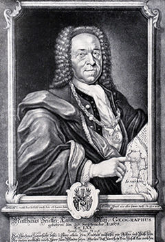
Founder of the French school of cartography (and of a mapmaking family) was a prolific mapmaker, producing
over 300 maps during his career. Originally a military engineer, he turned to cartography with the
encouragement of publisher Melchior Tavernier, who was impressed with Sanson's map of ancient Gaul, as
was Cardinal Richelieu in 1627. Nicholas wound up giving lessons in geography both to Louis XIII and to Louis
XIV. When Louis XIII, it is said, came to Abbeville, he preferred to be the guest of Sanson instead of occupying
lodgings provided by the town. At the end of one visit the king made Sanson a counselor of state. In 1643
Sanson began publishing his own maps, and later worked with the publisher Pierre Mariette. His 1658 "Cartes
Generales de toutes les parties du monde" had 113 maps compiled by Sanson and engraved/ printed by Pierre
Mariette, each having half the copyrights, with separate imprints on the maps. The 1665 edition had 166 maps,
the 1666 181, and the 1667 edition had 200 -- including 17 maps by Nicholas' son Guillaume.

Sanson, Nicholas [I], [Sanson d'Abbeville]: 1600 - 1667. Worked originally in
Abbeville, then in Paris
Abbeville, then in Paris
Sanson, Nicholas [II]: 1625 - 1648
Son of Nicholas I, and his intended heir -- prevented by Nicholas II's death from gunshot wounds. Three known works, the most
notable of which was "L'Europe..." a c1648 12-map compilation, engravings by A. Peyrounin, republished by Mariette in 1660,
and 1665; augmented with 40 additional maps -- and engraved by A.B. de la Place -- by Pierre Moullart-Sanson in 1697; other
editions were published in Frankfurt in 1679, and a Dutch edition in 1683.
Sanson, Guillaume: 1633 - 1703
Younger brother of Nicholas II, who, after Nicholas' II's death, succeeded to the family business with his younger brother
Adrien (1639-1718). After disagreements with Pierre Mariette II c1673, began working with Alexis-Hubert Jaillot. The
two brothers -- who collaborated until 1689 -- updated and reworked their father's maps, and produced several new maps
and atlases, most notably the "Atlas Nouveau," begun in 1670 and published in 1681.
Sanson, Pierre Moullart (Moulard): d. 1730
Son of Francoise Sanson -- the third child of Nicholas I -- and
Pierre Moulart. Appointed "Geographe du Roy" in 1695, third
in the family to hold the title, after Nicholas I and Guillaume.
In 1692 he bought the remainder of the plates from his uncles
Guillaume and Adrien, and republished them in an atlas,
incorporating some of his own work to replace plates lost to
Mariette. He was succeeded by three lawyer Jean Fremand,
priest Jacques-Simon Perrier, and Gilles Robert de
Vaugondy, who bought the remaining plates from Mariette.
Strubicz (Strobicz), Maciej: c. 1520 - c. 1604
Silesian (Polish) historian and Royal; Geographer to King Stefan Batory. He prepared "Magni Ducatus Lithuaniae, Livoniae et
Moscoviae descripto," his only surviving map, drawn c1581, published 1589 (by M. Kromer, in "Polonia sive in situ..."). A
later, improved, version was used by Mercator in 1595. Details from: Polish Museum
"Prince Michał Radziwiłł "the Orphan", son of Mikołaj "the Black," was voivode of Troki and Vilnius. Around 1585, he
began co-ordination of the work on a Grand Map of the Duchy of Lithuania...Among others, he hired the King Stefan
Batory’s cartographer Maciej Strubicz the Silesian, or "Slązak." Earlier, Strubicz began work on editing and re-working
maps of the territories subject to the King of Poland, particularly the map of Lithuania. A Mercator map, the best available
presentation of Lithuania and Livonia at that time, was not satisfactory. The amount and quality of the data on that part
of the Kingdom required devotion to the work on that map exclusively, which was Strubicz's intention. Correspondence
between Strubicz and Chancellor Jan Zamoyski, in which the cartographer asks Zamoyski for support in obtaining from
the King materials relating to the Duchy of Lithuania, proves that the work on the maps was well advanced in 1579: "I am
positive that there exists a more reliable and precise description of those Lithuanian Lands, made in the times of war,
without which I started my work, but am not able to complete it, I would be much obliged to Your Excellency for Your
support to my earlier pledge to His Majesty the King, to lend me for a short time such description of the Grand Duchy of
Lithuania."
Strubicz's own descriptions of Lithuania did not meet his requirements as materials for the new map. Such was probably
also the case with the map for which he was asking, as in all likelihood it was the work by Stanisław Pachłowiecki,
engraved in Rome, and made on the basis of data and materials collected during the Polock military campaign. Although
being the first example of military cartography in Poland, the map did not meet Strubicz's expectations. Therefore, the
cartographer finally decided to work in co-operation with Mikołaj Krzysztof Radziwiłł, hoping that the latter's energy and
spirit of enterprise may lead to the publication of a highly accurate map of the Grand Duchy of Lithuania, as planned. As
the starting point for research, Strubicz began collecting his own earlier works which he has been drawing since his
appointment to the Royal Chancellery in 1559. Diligent and precise as he was, Strubicz probably was not the sole author
of the map; it must have been a result of team work.…Judging by surprisingly precise location of places where Jesuit
colleges were, it seems that members of that order were involved in the work. Radziwiłł maintained close relations with
the Society of Jesus, and even built a college for Jesuits in his hometown Nies'wież. The sciences were held in great esteem
among members of that order, so in all probability, many measurements were made with state-of-the-art instruments and
based on mathematical and astronomical calculations. It is known that the outstanding Jesuit mathematician, Englishman
Jacob Bosgrave, was visiting Lithuania at the time when the map was created; some sources say that he was the founder
of the mathematical department of Vilnius Academy. It seems therefore probable that Bosgrave contributed to the work
of the editorial team, which was perhaps headed by the Prince himself. Bosgrave could have commissioned some work
with his students at the mathematical department, as he was very complimentary about them in his letters to General of
the order Claudius Aquaviva.
An analysis of Radziwiłł's correspondence allows the assumption that the Prince sought assistance in the work on the map
with Lithuanian, Belorussian and perhaps even Ukrainian magnates, and also with personalities at the Court. This clever
strategy allowed the enterprising Prince to make use of various influences and support to execute his ambitious task in
minute detail. One of such mighty assistants could have been voivode of Kiev, prince Konstanty Wasyl Ostrogski, to whom
Radziwiłł wrote in order to collect data on the lower course of the Dnieper."
Speed, John: c. 1552 - 1629; born Frandon, Cheshire; died London
Renowned historian and mapmaker, known primarily for his "Historie of Great Britaine," for which he compiled an atlas with
county maps and inset plans of English towns. But his "A Prospect of the Most Famous Parts of the World," published by
George Humble in 1627, was thought to be the first printed general atlas of the world published in Great Britain, and was
reissued under a variety of publishers until 1676.

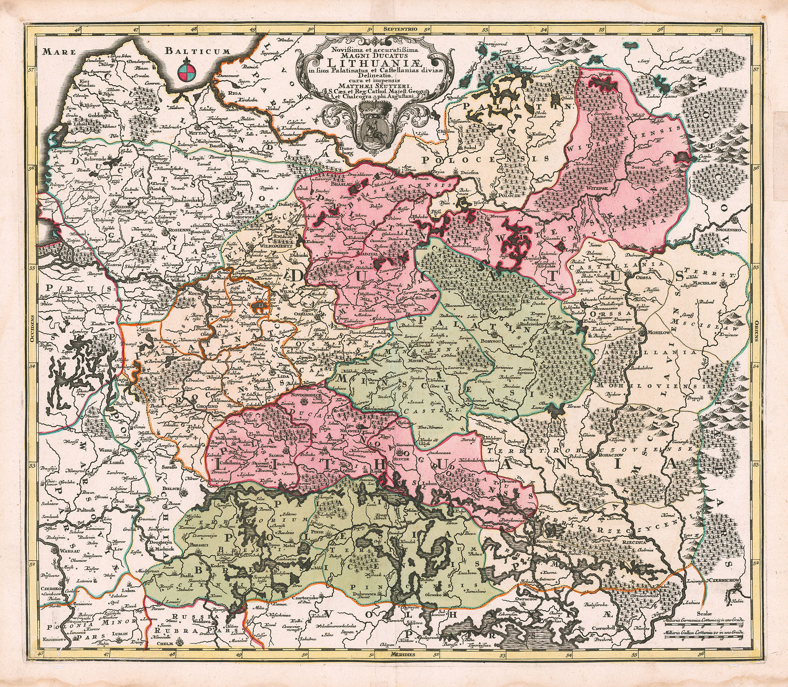
Seutter, Matthäus (The Elder): 1678–1757, born and died in Augsburg, Germany
Seutter left Augsburg in 1697 to apprentice as an engraver with J.B. Homann in Nuremberg. In 1707 he
started his own publishing firm in Augsburg, which became a major competitor to Homann's. In 1731 he
was given, by German Emperor Karl VI, the title of “Imperial Geographer,” and the notation "...Cum Gratia
et Priv..." began appearing under the top left frame line of his map "Novißima et accuratißima Magni
Ducatus Lithuaniӕ..." Seutter continued to publish until his death, at the height of his career, in 1757.
The firm continued until his son Albrecht Carl died in 1762. Then half of the firm's plates and maps were
purchased by Johann Michael Probst's Augsburg engraving firm. Soon the "...Magni Ducatus..." map
began appearing with the added notation "...Iohan Michael Probst..." under the top left frame line. The other
half of Seutter's plates and maps went to engraver Tobias Conrad Lotter, Seutter’s son-in-law. Most of
Seutter’s maps, were copies of work by Homann, Delisle and de Fer – only 40 were based on original work.
States of "Estats de la Couronne de POLOGNE.."
then "Tabula nova totius REGNI POLONIÆ..."
then "Tabula nova totius REGNI POLONIÆ..."
| 1655 Sanson 1st state |
| 1679-90 Sanson-Visscher 4th State |
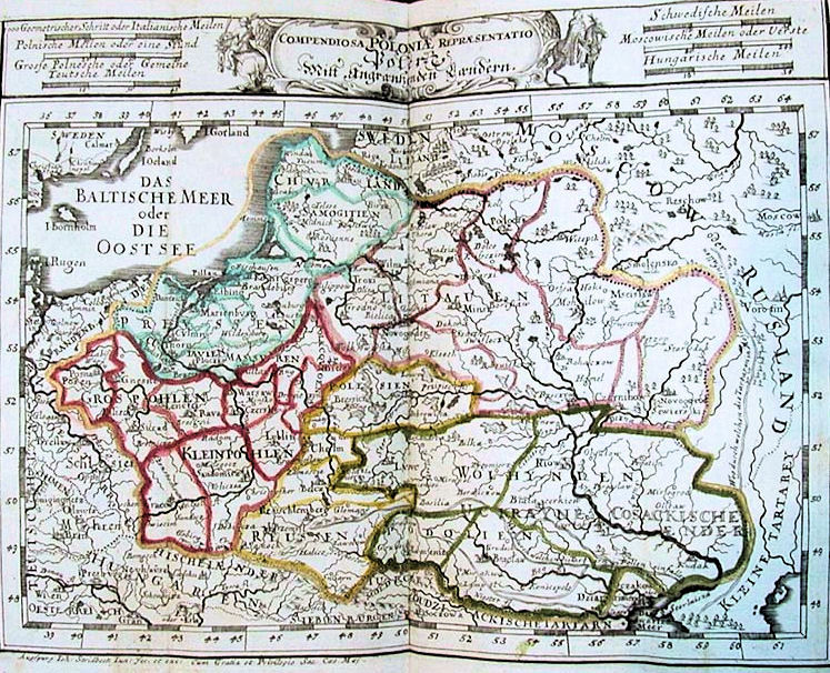
Stridbeck, Johan I (the Elder) 1640 - 1716, born Hamburg, died Augsburg; and II (the
Younger) 1666 - 1714:
Father and son mapmakers/editors/engravers/publishers of Augsburg. Their key map for this site: "Compendiosa
POLONIÆ Repræsentatio...," from their "Provinciarum Polonia Geog. Descriptio," Augsburg, printed by J. Koppmeyer. It was
supposedly the first atlas of Poland in small format. They also did map engraving for Augsburg publisher Gabriel Bodenehr,
and when, first, the son died, and then the father two years later, in 1716, the Stridbeck plates were purchased by Bodenehr,
who replaced the Stridbeck name under the left lower margin with his own. Bodenehr also changed the title of the plate in
some editions. On Bodenehr's death, the Stridbeck plates passed on to Georg Christophe Kilian (1709 - 1780), another
Augsburg engraver/publisher, who, in a number of atlases, including his "Kleiner Atlas" of 1757, retained the Bodenehr title in
the cartouche, but removed Bodenehr's name from under the left margin, and replaced it with his own.
| 1700 Stridbeck: "Compendiosa POLONIÆ Repræsentatio..." |

| 1716 Stridbeck - Bodenehr: "Compendiosa POLONIÆ Repræsentatio..." |

| 1716 Stridbeck - Bodenehr: "Geographische Vorstellung derer Königreiche Polen und Preussen mit deren incorpoierten Landen" |
| 1757 Stridbeck - Bodenehr - Kilian: "Geographische Vorstellung derer Königreiche Polen und Preussen mit deren incorpoierten Landen" |

| c. 1670 Sanson-Allard 3rd State |

| c. 1720 Sanson-Visscher- Schenk 6th State |

| 1663 [dated] Sanson 2nd State |
| 1703 [dated] Sanson 5th State |
| Pre-1731 Seutter 1st State |
Before 1731: 1st State: no "privilege"
Beginning 1731: 2nd State: "Privilege" added
Beginning 1762: 3rd State: "Probst" added in Baltic
Beginning 1731: 2nd State: "Privilege" added
Beginning 1762: 3rd State: "Probst" added in Baltic
In 1720 Seutter published the first edition of "Atlas novus sive Tabulae geographicae totius orbis faciem,"
Augsburg. He later reduced the maps from that atlas to produce his "Atlas Minor præcipua orbis
terrarum imperia..," described as both a pocket atlas and a school atlas, which contained the map
"Poloniæ Regnum ut et Magni Ducat. Lithuaniæ Accuratiss..," a reduced version of "Poloniæ Regnum ut
et Magni Ducatus Lithuaniæ Accuratiss..," with a coat of Arms in the cartouche. This is where things get
confusing. The first edition of the map, and the atlas from which it is sourced, is described by one of the
most knowledgeable map dealers as 1728. Nearly everyone else says the first edition is no earlier than
1740, with most saying it was 1744. Here is a summary of claimed atlas dates, paired with claimed dates
for my 17 good images of this map: 14 claimed atlas pub. dates; 10 different claimed map pub. dates.

1744 Seutter: " "Poloniæ
Regnum ut et Magni
Ducat. Lithuaniæ
Accuratiss..." From
www.davidrumsey.com
Regnum ut et Magni
Ducat. Lithuaniæ
Accuratiss..." From
www.davidrumsey.com
Claimed atlas date Claimed map date
1728 0
1740 3 (1 wrong)
1742 1 (Imago Poloniae)
1744 4 (2 wrong)
1745 1
1747 1
1756 0
1757 1 (wrong)
1760 1 (wrong)
Post-1762 0
1770 2
1772 1
1778 2 (1 wrong)
1785 1 (wrong)
14 18
1728 0
1740 3 (1 wrong)
1742 1 (Imago Poloniae)
1744 4 (2 wrong)
1745 1
1747 1
1756 0
1757 1 (wrong)
1760 1 (wrong)
Post-1762 0
1770 2
1772 1
1778 2 (1 wrong)
1785 1 (wrong)
14 18
Correctly dating this map's publication date:
1. Valid publication dates before 1764 must have the coat of
arms of Augustus III
2. The map cannot have been published before 1734
3. T.C. Lotter, working for Matthäus Seutter, engraved the
map. After Matthäus died in 1757, his son Albrecht continued
the firm, but Lotter inherited half Seutter's plates, and set up
his own publishing firm in 1758, the other half of plates bought
by Johann Michael Probst. Below center frameline:
Publisher
- Before 1758: Seutter
- Beginning 1758: T.C. Lotter
- Last editions: Johann Martin Will
- seen in claimed 1770, 1772 and 1778 maps; 1785 at
IMAGO POLONIAE
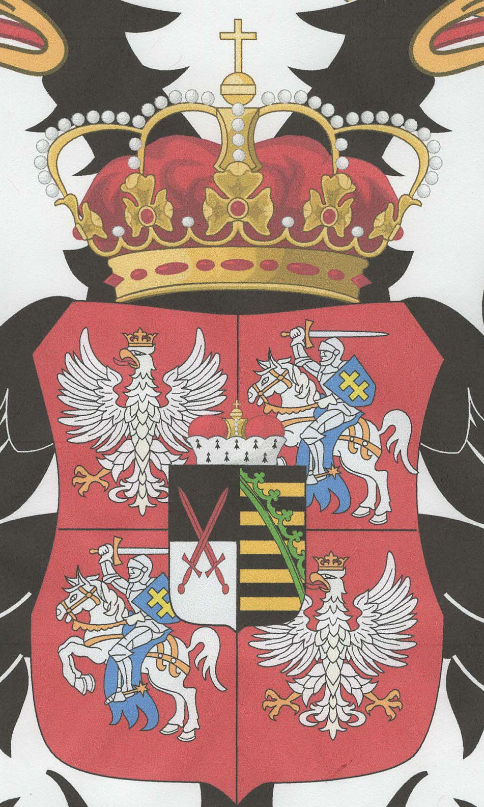
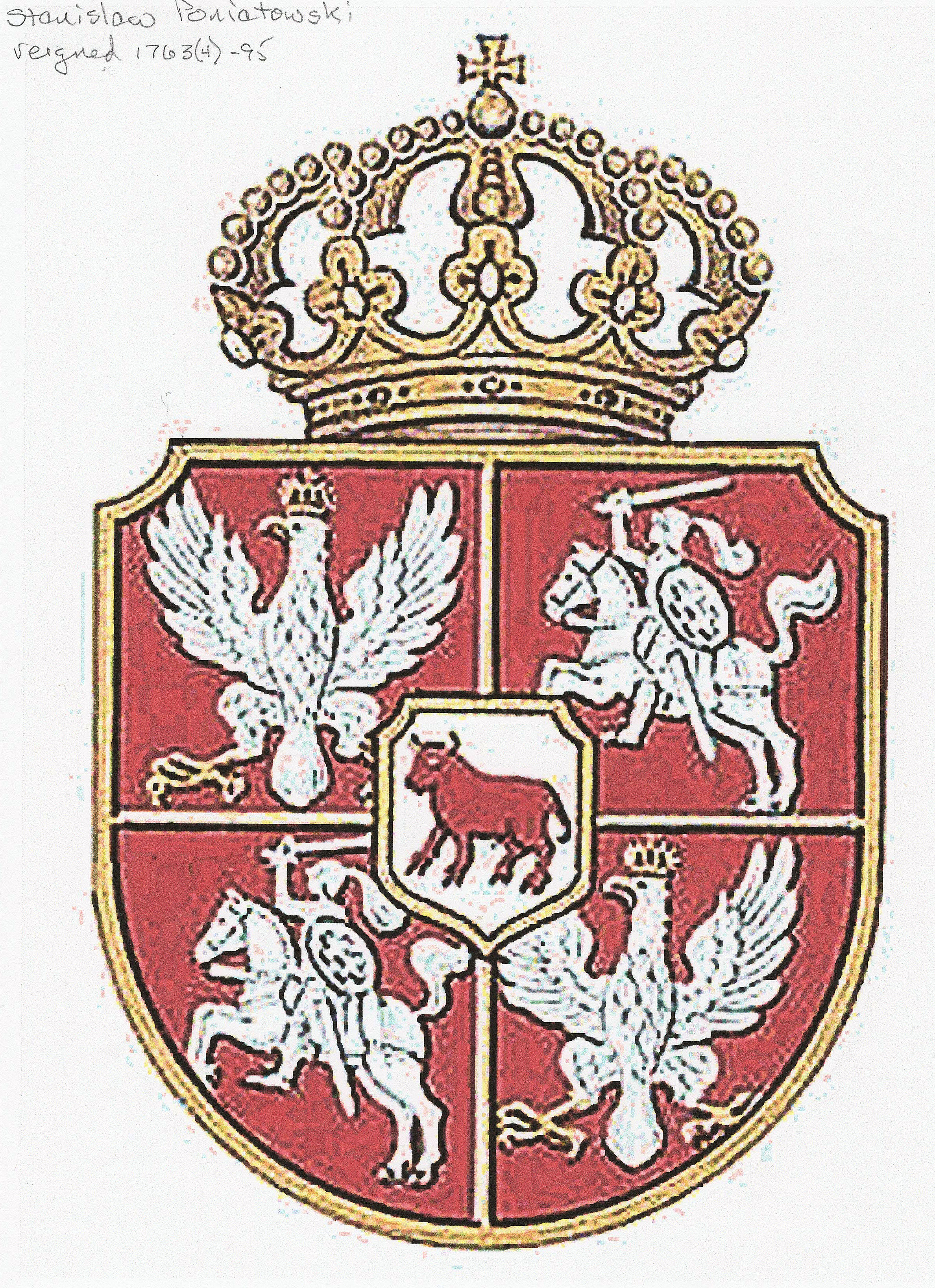
| Coats of Arms on this map, and when the Grand Dukes ruled |
| Augustus III 1734-63 |
| Stanislaw Poniatowski 1764-95 |
Distinguishing between the
1648 Peyrounin and 1683
d'Winter versions of "Estats
de la Couronne de Pologne:"
1648 Peyrounin and 1683
d'Winter versions of "Estats
de la Couronne de Pologne:"
| 1648 |
| 1648 |
| 1683 |
| 1683 |