Historical Maps: Showing the area by date depicted, not by date created


700 - 800 "THE SLAVS,
VIII - IXc."
VIII - IXc."
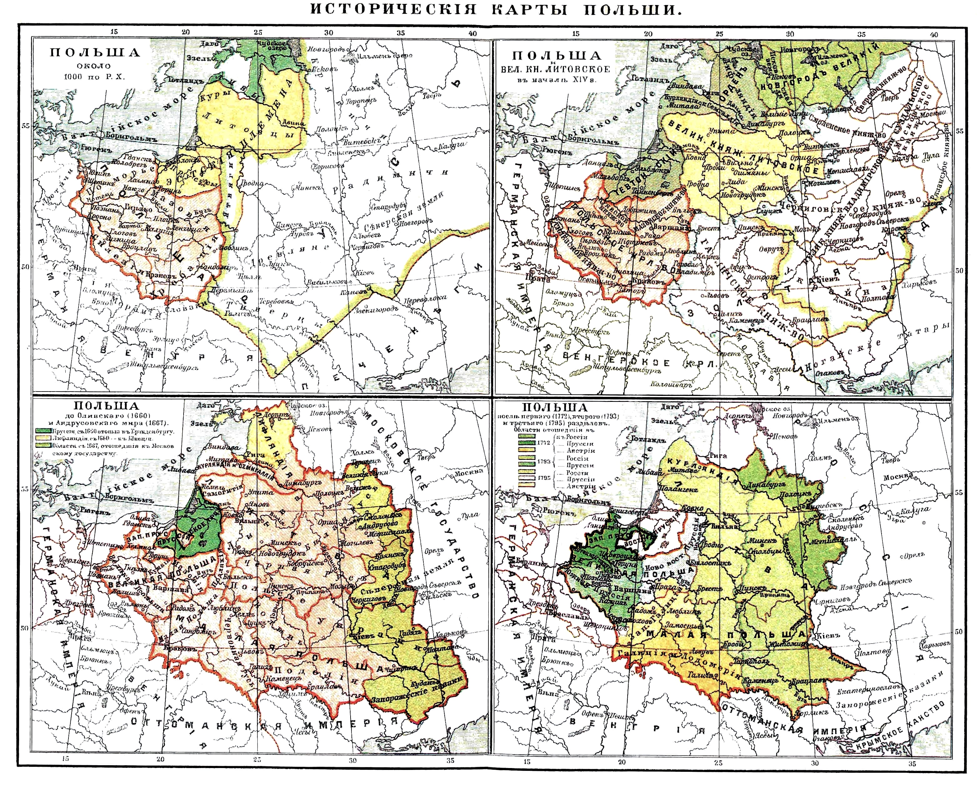
1000-1772 "Karten zur Geschichte Polens und Des
Westlichen Russlands,"1908, Karl Wolf, Leipzig.
And a DETAIL image of the area in the year 1000.
Westlichen Russlands,"1908, Karl Wolf, Leipzig.
And a DETAIL image of the area in the year 1000.


1000 "Baltic Lands." From
the 1903 "Atlas to Freeman's
Historical Geography"
the 1903 "Atlas to Freeman's
Historical Geography"

1220 "Baltic Lands." From
the 1903 "Atlas to Freeman's
Historical Geography"
the 1903 "Atlas to Freeman's
Historical Geography"

1270 "Baltic Lands." From
the 1903 "Atlas to Freeman's
Historical Geography"
the 1903 "Atlas to Freeman's
Historical Geography"
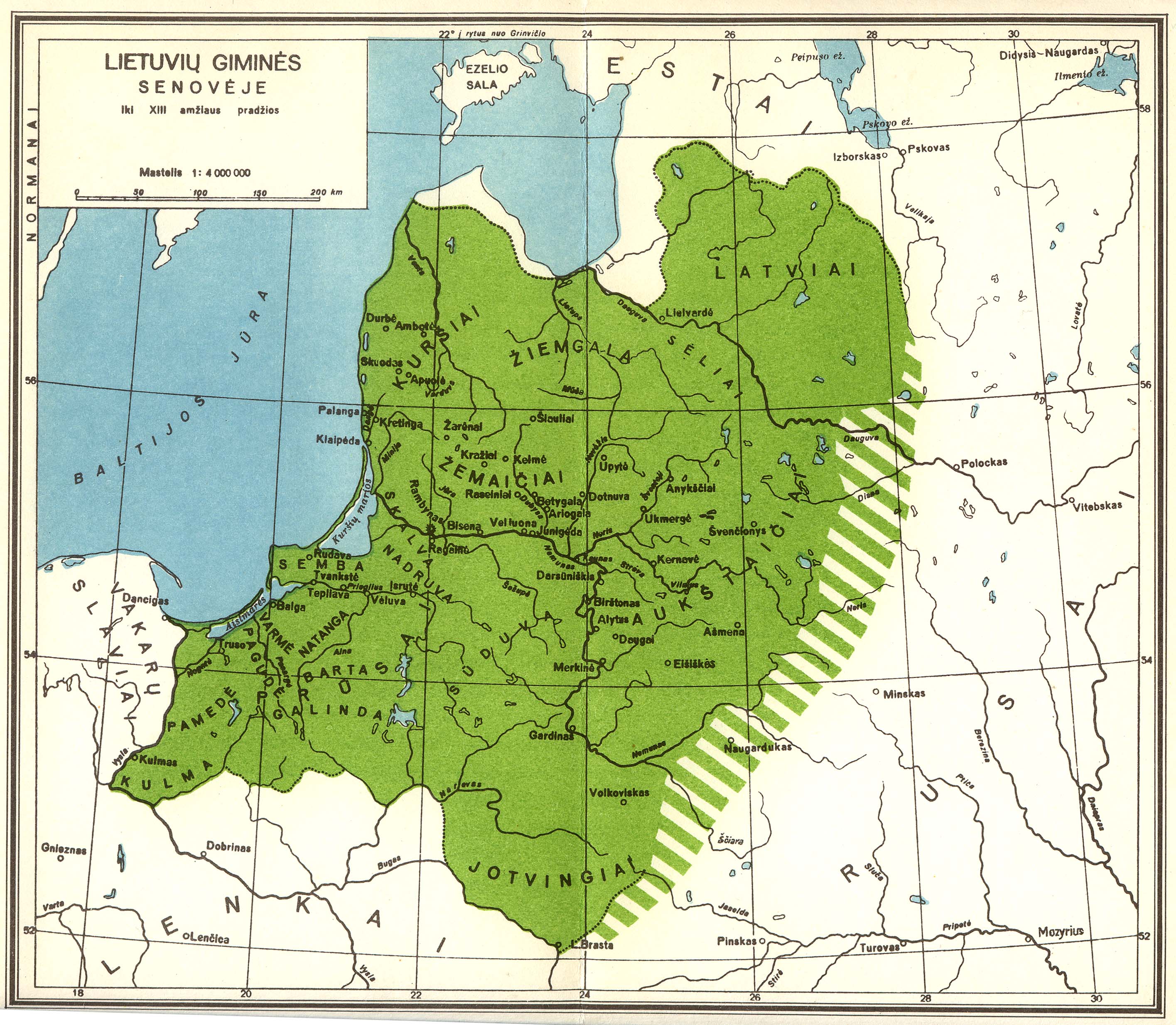
1200 "LIETUVIU GIMINES
SENOVEJE." (Ancient
lands of Lithuania, to the
13th century.)
SENOVEJE." (Ancient
lands of Lithuania, to the
13th century.)

13th Cent.: "LIETUVA:
MINDAUGO LAIKAIS."
(The Age of Mindaugas.)
MINDAUGO LAIKAIS."
(The Age of Mindaugas.)
1350-60 "Baltic Lands."
From the 1903 "Atlas to
Freeman's Historical Geography"
From the 1903 "Atlas to
Freeman's Historical Geography"

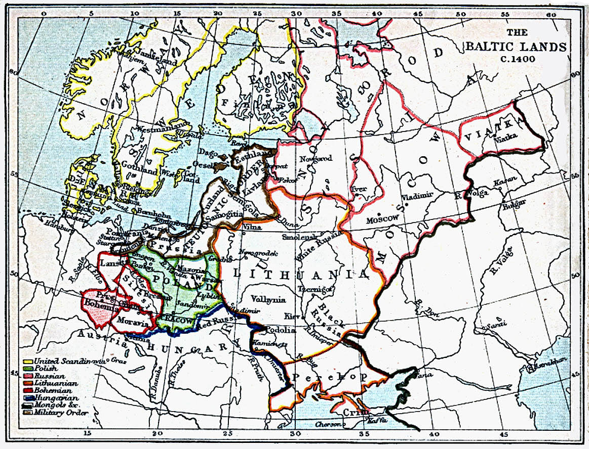
1400 "Baltic Lands." From
the 1903 "Atlas to Freeman's
Historical Geography"
the 1903 "Atlas to Freeman's
Historical Geography"

1478 "Baltic Lands." From
the 1903 "Atlas to Freeman's
Historical Geography"
the 1903 "Atlas to Freeman's
Historical Geography"

14th-15th Cent.
"Litva." From
www.belarusguide.com
"Litva." From
www.belarusguide.com
13th-15th Cent.
"Lithuanian State."
"Lithuanian State."


15th Cent. "Lietuva."
| 1386-1572 Karl von Spruner: "POLEN UND LITTHAUEN unter den Jagjellonen," from Goth's "Historisch Geographi- scher Hand- atlas," 1855. |

1563 "Baltic Lands." From
the 1903 "Atlas to Freeman's
Historical Geography"
the 1903 "Atlas to Freeman's
Historical Geography"

1569 "The Polish
Republic, Vassal states."
Republic, Vassal states."

1617 "Baltic Lands." From
the 1903 "Atlas to Freeman's
Historical Geography"
the 1903 "Atlas to Freeman's
Historical Geography"

1634-60 "Polish Republic."

1635 "Polish-Lithuanian
Commonwealth."
Commonwealth."

1686 "Republic of Both
Nations."
Nations."
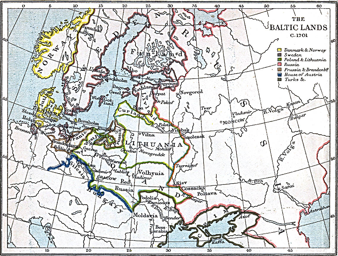
1701 "Baltic Lands." From
the 1903 "Atlas to Freeman's
Historical Geography"
the 1903 "Atlas to Freeman's
Historical Geography"

1772 "POLAND after the
first partition."
first partition."

1772 "Baltic Lands." From
the 1903 "Atlas to Freeman's
Historical Geography"
the 1903 "Atlas to Freeman's
Historical Geography"

1793 "POLAND after the
second parition."
second parition."

1795 "Baltic Lands." From
the 1903 "Atlas to Freeman's
Historical Geography"
the 1903 "Atlas to Freeman's
Historical Geography"

1795 "POLAND."

1812 "Russian Campaign." Napoleon's Grand
Armee: advance and retreat through Lithuania.
Armee: advance and retreat through Lithuania.

1807-46 "Karte
kongresspolen."
kongresspolen."

1125 Karl Spruner von Merz: "Die Volker and Reiche der
SLAVEN Zwischen Elbe and Don." From Gotha's 1846
"Historisch- Geographer Hand Atlas." 1846. 16 x 11 inches /
41 x 28 cm. With DETAIL images of the east and west halves.
SLAVEN Zwischen Elbe and Don." From Gotha's 1846
"Historisch- Geographer Hand Atlas." 1846. 16 x 11 inches /
41 x 28 cm. With DETAIL images of the east and west halves.


1772-1815 Conrad Malte-
Brun: "Carte Historique DE
LA POLOGNE, presentant
ses divers desmembremens
1772, 1794, 1795, 1807 et 1815." 1860. Also a DETAIL image.
Brun: "Carte Historique DE
LA POLOGNE, presentant
ses divers desmembremens
1772, 1794, 1795, 1807 et 1815." 1860. Also a DETAIL image.


9th ("Scholar's") ed.,
Encyclopedia Britannica:
"Kingdom of Poland, before
its union with Lithuania...
up to Napoleon I,"
published 1875-89.
Encyclopedia Britannica:
"Kingdom of Poland, before
its union with Lithuania...
up to Napoleon I,"
published 1875-89.

1918-19

1919 - July 9, 1940
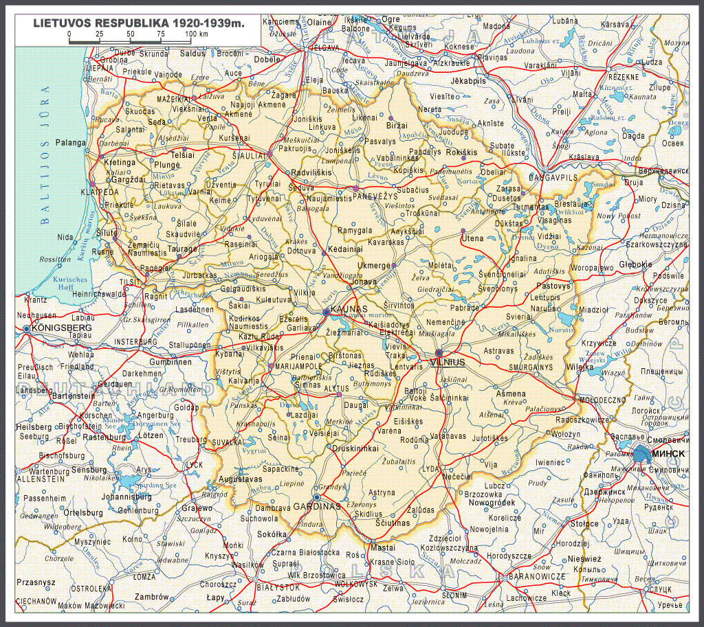
1920-39 Lithuanian
Republic.
Republic.

1921-38

1939 - June 15, 1940

June 16, 1940 - June 21, 1941

July 22, 1941 - July 8, 1944

1918-45 Lithuania, from "Mokyklinis Lietuvos istorijos Atlasas, V-X Klasems," published by Pradai, Vilnius, 1997. (AK)
July 9, 1944 - January 28, 1945

1918-45 J. Andrius: "SUTARTI ZENKLAI"
(Lithuanian boundaries)
(Lithuanian boundaries)

1772-95 Partitions.

13th cent. Karl Spruner
von Merz. 1. "Die OST- SEE
LAENDER...im (13th
Cent)" 2. "... PREUSSEN
und LIVLAND, 1525-62."
von Merz. 1. "Die OST- SEE
LAENDER...im (13th
Cent)" 2. "... PREUSSEN
und LIVLAND, 1525-62."

"Carte de LITUANIE,"
published 1918. From
the National Museum of
Lithuania.
published 1918. From
the National Museum of
Lithuania.
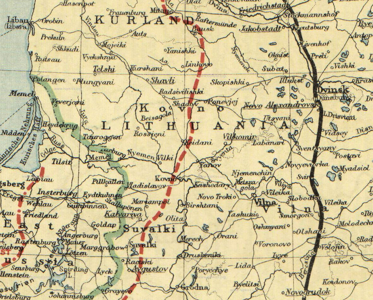
1772-1815 Joseph Meyer: "...POLEN..." 250 x 185 mm. From the
1849 "Meyer's Neuester Zeitungs Atlas," the first with insets of
cities. Also a DETAIL image of Wilna. AK
1849 "Meyer's Neuester Zeitungs Atlas," the first with insets of
cities. Also a DETAIL image of Wilna. AK
The history of the Balts by Marija Gimbutas

1919-39 Lithuanian
borders
borders

1920 "THE RUSSIAN
BATTLEFRONTS,"
from "The People's Atlas," with fronts from 1914 - Armistice
Line, December 2, 1917. From London Geograhical Institute
BATTLEFRONTS,"
from "The People's Atlas," with fronts from 1914 - Armistice
Line, December 2, 1917. From London Geograhical Institute

1660-67 "POLEN"


18th Cent.
"RUSSIE ET
POLOGNE,"
from Vidal-
Lablache's 1912 "Atlas General Histoire et Geographie." Also two DETAIL images/
"RUSSIE ET
POLOGNE,"
from Vidal-
Lablache's 1912 "Atlas General Histoire et Geographie." Also two DETAIL images/

The United States Military Academy (USMA) at West Point has an extensive collection of war-related maps at www.usma.edu. Below are DETAIL images of some maps that show what was happening in the Lithuanian area during World Wars I and II.
1914 Central Europe: Planned
Army Concentration Areas
Army Concentration Areas
1914: Operations on the
Eastern Front
Eastern Front


1915, Feb.: Battle of
Masuria
Masuria

1915 Summer: Russian
withdrawal.
withdrawal.

1916 March: Eastern Front

1917 Oct.: German Baltic
amphibious operations
amphibious operations

1917-18: Armistice and
Brest-Litovsk lines.
Brest-Litovsk lines.

1941, June 22 - Aug.
25: German invasion of
the Baltics and Russia
25: German invasion of
the Baltics and Russia

1941 Aug. 26 - Dec. 6:
Germans advance on
Moscow
Germans advance on
Moscow

1941 Dec. 5 - May 7,
1942: Soviet Winter
Offensive
1942: Soviet Winter
Offensive

1943 July 17 - Dec. 1:
Soviet Summer and Fall
Offensives
Soviet Summer and Fall
Offensives

1944 Aug. 19 - Dec. 31: Soviet
Baltic Campaigns
Baltic Campaigns

1944 June 22 - Aug. 19:
Operation Bagration
Operation Bagration

1945, Jan. 12 - March 30:
Soviet Offensive to the Oder
Soviet Offensive to the Oder

1772-95 "POLAND: THE
PARTITIONS," 1912
Cambridge History Atlas.
PARTITIONS," 1912
Cambridge History Atlas.

1569 "Poland and Lithuania:
The Union of Lublin." 1912
Cambridge History Atlas
The Union of Lublin." 1912
Cambridge History Atlas

1400 Gustav Droysen:
"POLEN unter Jagello:"
1886 "Allgemeiner
historischer Handatlas."
"POLEN unter Jagello:"
1886 "Allgemeiner
historischer Handatlas."


1772, 1793, 1795 "POLEN," the first, second, and third partitions
from the 1880 Swedish "Historisk Atlas" by Hildebrand and Selander
from the 1880 Swedish "Historisk Atlas" by Hildebrand and Selander

| 1863-64 "Battles of the "January" Uprising in Lithuania and Russia," by Stanislaw Zielinski, created 1913. From www.wbc.poznan.pl |

1654 Lithuania's
Admin. Divisions
Admin. Divisions


1572-1795 "L'Ancienne
Pologne," from G. Heck's
1842 "Atlas Geographique"
Pologne," from G. Heck's
1842 "Atlas Geographique"

1572 - 1795 Karl von Spruner: "Polen,"
from Goth's "Historisch Geographischer
Handatlas," 1854.
from Goth's "Historisch Geographischer
Handatlas," 1854.

c1200 Baltic tribes. From
www.latviahistory.wordpress.com
www.latviahistory.wordpress.com

Pre-Crusades Latvian Tribes. From
www.latviahistory.wordpress.com
www.latviahistory.wordpress.com


1914: "Russia in Europe," from "An Historical Atlas
of Modern Europe from 1789 to 1922," Oxford
University Press, 1924. Also a DETAIL image.
of Modern Europe from 1789 to 1922," Oxford
University Press, 1924. Also a DETAIL image.


1000 - 1795 "Polish and
Lithuanian History.
Lithuanian History.
1809 "Baltic Lands." From
the 1903 "Atlas to Freeman's
Historical Geography"
the 1903 "Atlas to Freeman's
Historical Geography"
