Maps of Historical Lithuania After 1795: By date depicted,
not by date created
not by date created

1812 "Russian Campaign."
Napoleon's Grand Armee:
advance/retreat through
Lithuania.
Napoleon's Grand Armee:
advance/retreat through
Lithuania.

1807-46 "Karte
kongresspolen."
kongresspolen."
1772-1815 Thierry (engraver) - Conrad Malte-Brun
(publisher): "Carte Historique de la Pologne, presentant
ses divers desmembremens 1772, 1794, 1795, 1807 et
1815."
(publisher): "Carte Historique de la Pologne, presentant
ses divers desmembremens 1772, 1794, 1795, 1807 et
1815."

| 1918-19 |

| 1919 - July 9, 1940 |
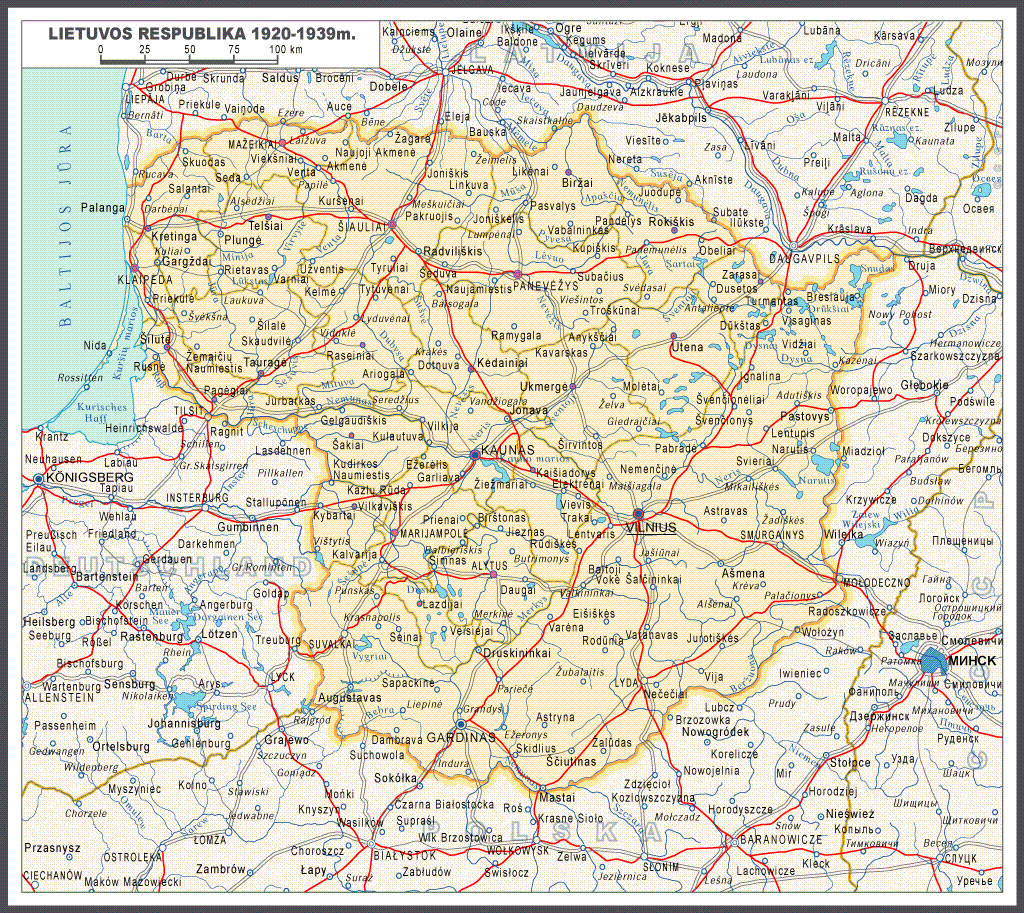
1920-39 Lithuanian
Republic.
Republic.

| 1921-38 |

| 1939 - June 15, 1940 |

| June 16, 1940 - June 21, 1941 |

| July 22, 1941 - July 8, 1944 |

1918-45 Lithuania, from "Mokyklinis Lietuvos istorijos Atlasas, V-X Klasems," published by Pradai, Vilnius, 1997. (AK)
| July 9, 1944 - January 28, 1945 |

1918-45 J. Andrius:
"SUTARTI ZENKLAI"
(Lithuanian boundaries)
"SUTARTI ZENKLAI"
(Lithuanian boundaries)
1772-1815 Joseph Meyer: "...POLEN..." 25 x 18.5 cm.
On the left from the 1849 "Meyer's Neuester Zeitungs
Atlas," the first with insets of cities; on the right from
the 1855 edition.
On the left from the 1849 "Meyer's Neuester Zeitungs
Atlas," the first with insets of cities; on the right from
the 1855 edition.
1919-39 Lithuanian
borders. From Renate3
on wikipedia, edited by
Kapochunas
borders. From Renate3
on wikipedia, edited by
Kapochunas

1920 "The Russian
Battlefronts,"
from "The People's
Atlas," with fronts
from 1914 -
Armistice Line,
December 2, 1917.
From London
Geograhical Institute
Battlefronts,"
from "The People's
Atlas," with fronts
from 1914 -
Armistice Line,
December 2, 1917.
From London
Geograhical Institute
The United States Military Academy (USMA) at West Point has a collection of
war-related maps at www.usma.edu. Below are DETAIL images of WWI maps.
war-related maps at www.usma.edu. Below are DETAIL images of WWI maps.
1914 Central
Europe: Planned
Army Concen-
tration Areas
Europe: Planned
Army Concen-
tration Areas
1914: Operations
on the Eastern
Front
on the Eastern
Front


1915, Feb.:
Battle of Masuria
Battle of Masuria

1915 Summer:
Russian
withdrawal.
Russian
withdrawal.

1916 March:
Eastern Front
Eastern Front


1917-18: Armistice
and Brest-Litovsk
lines.
and Brest-Litovsk
lines.

1941, June 22 - Aug.
25: German invasion of
the Baltics and Russia
25: German invasion of
the Baltics and Russia

| 1941 Aug. 26 - Dec. 6: Germans advance on Moscow |

| 1941 Dec. 5 - May 7, 1942: Soviet Winter Offensive |

| 1943 July 17 - Dec. 1: Soviet Summer and Fall Offensives |

| 1944 Aug. 19 - Dec. 31: Soviet Baltic Campaigns |

| 1944 June 22 - Aug. 19: Operation Bagration |

| 1945, Jan. 12 - Mar. 30: Soviet Offensive to the Oder |

1863-64
"Battles of
the "January"
Uprising in
Lithuania
and Russia,"
by Stanislaw
Zielinski,
created 1913.
From www.wbc.
poznan.pl
"Battles of
the "January"
Uprising in
Lithuania
and Russia,"
by Stanislaw
Zielinski,
created 1913.
From www.wbc.
poznan.pl

The United States Military Academy (USMA) at West Point war-related maps, at www.usma.edu., relating to WWII in the Lithuanian area.

1916-45: "Polen im
20.Jahrhundert"
20.Jahrhundert"

1867 - 1914 "Gubernijas"

1812 Bernhard
Darbishire: "Western
Russia and Poland:
Opening of Campaign."
From the 1915 Oxford Univ.
Press "War Atlas."
Darbishire: "Western
Russia and Poland:
Opening of Campaign."
From the 1915 Oxford Univ.
Press "War Atlas."

1842 Henry G. Bohn:
"POLAND describing ITS
ANCIENT BOUNDARY,"
London. From
www.antiquemapsandprints
"POLAND describing ITS
ANCIENT BOUNDARY,"
London. From
www.antiquemapsandprints
1919-39 Vytautas Birštonas (mapmaker):
"Lithuania After the Czars: The Interwar
Period." With inset maps showing
ethnicity by district based on the 1897
Russian census. Updated September 2017.
"Lithuania After the Czars: The Interwar
Period." With inset maps showing
ethnicity by district based on the 1897
Russian census. Updated September 2017.

1772 - 1921:
"PARTITIONS OF
POLAND," published
1943. From periodpaper on
eBay
"PARTITIONS OF
POLAND," published
1943. From periodpaper on
eBay

1618-1810 "POLEN..." from an 1871
"Spruner-Menke Hist. Handatlas No. 71," at
1: 5 000 000. AK
"Spruner-Menke Hist. Handatlas No. 71," at
1: 5 000 000. AK
"Map of Part of Russia to
Illustrate the Campaigns of
1812," Edinburgh, 6 x 8.25
inches, from "Alison's Hist-
ory of Europe," 1848. From
www.antiquaprintgallery.com
Illustrate the Campaigns of
1812," Edinburgh, 6 x 8.25
inches, from "Alison's Hist-
ory of Europe," 1848. From
www.antiquaprintgallery.com

1812 "Map of the
Russian Campaign,
March of Napoleon,
Retreat from Moscow."
Russian Campaign,
March of Napoleon,
Retreat from Moscow."


"CHARTE des Kriegs
Schauplatzes in
LITHAUEN im Jahre
1831" (1831 battle
sites). From www.
karty.by
Schauplatzes in
LITHAUEN im Jahre
1831" (1831 battle
sites). From www.
karty.by

Before 1795 and in 1835 T.
Starling: POLAND," London, 19 x
15 cm., from "The Royal Cabinet
Atlas, And Universal Compendium
Of All Places In The Known World."
Also a page of Poland towns and
their lat/longs. From jpmaps.co.uk
Starling: POLAND," London, 19 x
15 cm., from "The Royal Cabinet
Atlas, And Universal Compendium
Of All Places In The Known World."
Also a page of Poland towns and
their lat/longs. From jpmaps.co.uk

1931-39 "Adminis-
trative boundaries
between Poland and
the Belarussian SSR."
From www.karty.by
trative boundaries
between Poland and
the Belarussian SSR."
From www.karty.by

1831 Joseph Meyer: "Die REPUBLIK
POLEN nack ihrem Bestande im
Jahre 1772, und das KONIGREICH
POLEN seit dem Jahre 1815." From
the 1852 "Meyer- Zeitung Atlas."
POLEN nack ihrem Bestande im
Jahre 1772, und das KONIGREICH
POLEN seit dem Jahre 1815." From
the 1852 "Meyer- Zeitung Atlas."


1920-39 "Kreis
Heydekrug" Boundary
changes relative to
Kreis Niederung
Heydekrug" Boundary
changes relative to
Kreis Niederung


1915 "Eesti Eesti VABADUSSÕJA Sõjateatri Kaart" (Estonian
War of Independence Theater of War Map), Tartu, in nine
images published in 1939. From The European Library.org
War of Independence Theater of War Map), Tartu, in nine
images published in 1939. From The European Library.org

1918 "[Second]
Kingdom of Lith-
uania," a short-
lived idea for
a constitutional
monarchy.
From wikimedia
Kingdom of Lith-
uania," a short-
lived idea for
a constitutional
monarchy.
From wikimedia


| c. 1942 www.karty.by |
Two depictions of "REICHSKOMMISSARIAT
OSTLAND."
OSTLAND."

1914 "The alleged
Conspiracy between the
Kaiser and the Archduke
Francis Ferdinand,"
June, 1914. From karty.by
Conspiracy between the
Kaiser and the Archduke
Francis Ferdinand,"
June, 1914. From karty.by


1807-15 ""Księstwo
Warszawskie," showing
areas added in 1809, from
"Polski Atlas Kongresowy,"
from 1921. From RCIN.org
Warszawskie," showing
areas added in 1809, from
"Polski Atlas Kongresowy,"
from 1921. From RCIN.org
1807 Jan Marcin Banse-
mer - Piotr Falkenhagen
Zaleski: "POLAND in 1807
(after the Treaty of Tilsit)"
Krakow and London, from
"The [1837] Atlas contain-
ing Ten Maps of Poland..."
From www.easteurotopo .org
mer - Piotr Falkenhagen
Zaleski: "POLAND in 1807
(after the Treaty of Tilsit)"
Krakow and London, from
"The [1837] Atlas contain-
ing Ten Maps of Poland..."
From www.easteurotopo .org
1807-09 Joachim Lelewel - Eligiusz Niewiadom-
ski: "Księstwo Warszawskie utworzone przez Napol-
eona I. r. 1807 powiększone 1809," (Duchy of
Warsaw created by Napoleon, until 1809), from
two editions of his "Atlas do Dziejów Polski..." From
http://www.sbc.org.pl/dlibra/via www.mapywig.org
ski: "Księstwo Warszawskie utworzone przez Napol-
eona I. r. 1807 powiększone 1809," (Duchy of
Warsaw created by Napoleon, until 1809), from
two editions of his "Atlas do Dziejów Polski..." From
http://www.sbc.org.pl/dlibra/via www.mapywig.org

1809 Jan Marcin Banse-
mer - Piotr Falkenhagen
Zaleski: "POLAND in 1809
(after the Treaty of Schön-
brunn)" Krakow and Lon-
don, from "The Atlas con-
taining Ten Maps of Poland
..." From www.easteurotopo .org
mer - Piotr Falkenhagen
Zaleski: "POLAND in 1809
(after the Treaty of Schön-
brunn)" Krakow and Lon-
don, from "The Atlas con-
taining Ten Maps of Poland
..." From www.easteurotopo .org


Jan Marcin Bansemer -
Piotr Falkenhagen Zaleski:
"POLAND in 1815 (after
the Congress of Vienna),"
Krakow and London, from
"The [1837] Atlas contain-
ing Ten Maps of Poland."
From www.easteurotopo .org
Piotr Falkenhagen Zaleski:
"POLAND in 1815 (after
the Congress of Vienna),"
Krakow and London, from
"The [1837] Atlas contain-
ing Ten Maps of Poland."
From www.easteurotopo .org
Joachim Lelewel - Eligiusz Niewiadomski:
"Królestwo Polskie utworzone r. 1815, na Kongresie
Wiedeńskim" (The Kingdom of Poland in 1815,
created by the Congress of Vienna), from two
editions of his "Atlas do Dziejów Polski..." From http:
//www.sbc.org.pl/dlibra/via www.mapywig.org
"Królestwo Polskie utworzone r. 1815, na Kongresie
Wiedeńskim" (The Kingdom of Poland in 1815,
created by the Congress of Vienna), from two
editions of his "Atlas do Dziejów Polski..." From http:
//www.sbc.org.pl/dlibra/via www.mapywig.org
"Kongres Wiedeński
(1815)" (Congress of
Vienna), from 1921's
"Polski Atlas Kongresowy."
From RCIN.org
(1815)" (Congress of
Vienna), from 1921's
"Polski Atlas Kongresowy."
From RCIN.org
1921 Riga Treaty Boun-
daries. Lithuania never
accepted the loss of Vilnius,
its historic capital. Vilnius
and the area surrounding it
was never considered part
of the Kingdom of Poland.
daries. Lithuania never
accepted the loss of Vilnius,
its historic capital. Vilnius
and the area surrounding it
was never considered part
of the Kingdom of Poland.


1815 - 1914
"Poland," Edin-
burgh, publish-
ed by John Bart-
hole- mew. From y
ork - on eBay
"Poland," Edin-
burgh, publish-
ed by John Bart-
hole- mew. From y
ork - on eBay

1815 Léonard Jakób
Chodźko: "Carte Generale
Routiere Historique et
Statistique...POLOGNE...
consomme dans le congres
de Vienne," Paris, 1850.
From www.bg.umcs.lublin.
pl/nowa/mapy
Chodźko: "Carte Generale
Routiere Historique et
Statistique...POLOGNE...
consomme dans le congres
de Vienne," Paris, 1850.
From www.bg.umcs.lublin.
pl/nowa/mapy


Jan Marcin Bansemer -
Piotr Falkenhagen Zaleski:
"POLAND in 1831 (after
the War of Independence),"
Krakow, London, from
"The [1837]Atlas contain-
ing Ten Maps of Poland."
From www.easteurotopo .org
Piotr Falkenhagen Zaleski:
"POLAND in 1831 (after
the War of Independence),"
Krakow, London, from
"The [1837]Atlas contain-
ing Ten Maps of Poland."
From www.easteurotopo .org
1831 Josef Chodźko:
"Carta della Polonia...,"
Florence, 21.3 x 18.8
inches, engraved by J.
Carolus Castellini. From
www.oldworldauctions.com
"Carta della Polonia...,"
Florence, 21.3 x 18.8
inches, engraved by J.
Carolus Castellini. From
www.oldworldauctions.com

1772 - 1846 Jerzy Topolski:
"Poland during the parti-
tions," from his 1987
"Outline History of Poland."
The map erases Lithuania.
From acienciala.faculty.ku.edu/
"Poland during the parti-
tions," from his 1987
"Outline History of Poland."
The map erases Lithuania.
From acienciala.faculty.ku.edu/

1919 "Revendications Po-
loniases" (Claims of Poland),
Warsaw, from the 1921
"Polski Atlas kongresowy
/Atlas problémes territor-
iaux Pologne." From RCIN.org
loniases" (Claims of Poland),
Warsaw, from the 1921
"Polski Atlas kongresowy
/Atlas problémes territor-
iaux Pologne." From RCIN.org

Boguslaw Kaczmarski:
"Rozwoj Terytorialny
Panstwa Polskiego w
Latach 1918-1922" (Terri-
torial Development of the
Polish State, 1918-1922),
From www.mapywig.org
"Rozwoj Terytorialny
Panstwa Polskiego w
Latach 1918-1922" (Terri-
torial Development of the
Polish State, 1918-1922),
From www.mapywig.org
1799 Smuglewicz : "Wilno
w końcu wieku XVIII-go"
(Vilnius at the end of the
eighteenth century)
published 1912. From The
Wroblewski Library of the
Lithuanian Academy of Sciences:
elibrary.mab.lt/
w końcu wieku XVIII-go"
(Vilnius at the end of the
eighteenth century)
published 1912. From The
Wroblewski Library of the
Lithuanian Academy of Sciences:
elibrary.mab.lt/


1917 Oct.:
German Baltic
amphibious
operations
German Baltic
amphibious
operations
1835 Jordan: "Reino de
Polonia ó sea la parte
unida a la Rusia..." (King-
dom of Poland or the part
united to Russia by the
1795 partition...) From
Spanish Ministry of Defense
Virtual Library: www.
bibliotecavirtualdefensa.es
Polonia ó sea la parte
unida a la Rusia..." (King-
dom of Poland or the part
united to Russia by the
1795 partition...) From
Spanish Ministry of Defense
Virtual Library: www.
bibliotecavirtualdefensa.es
| AK |
| Antiquariat Reinhold Berg: www.bergbook.com |
| Published 1908 |
| Published 1920 |
| Published 1908 |
| Published 1920 |
| c. 1943 www.valtakunta.eu |

1918 "Eastern
Europe: 1914.
Operations
during 1918."
Europe: 1914.
Operations
during 1918."


1772, 1794, 1795, 1807,
1815 Conrad Malte-Brun:
"Carte historique de la
Pologne presentant ses
divers demembremens,"
Paris, 29,5 x 22 cm,
published 1837. From
antiquariat-voelkel on eBay.de
1815 Conrad Malte-Brun:
"Carte historique de la
Pologne presentant ses
divers demembremens,"
Paris, 29,5 x 22 cm,
published 1837. From
antiquariat-voelkel on eBay.de

1831 [dated] Rudolph Schlicht (publisher): "Historisch-
statistisch-geographische Darstellung des Koenigreichs
Polen, 1770. 1773, 1793, 1795, 1807, 1815,"
Mannheim, 43 x 48 cm.
statistisch-geographische Darstellung des Koenigreichs
Polen, 1770. 1773, 1793, 1795, 1807, 1815,"
Mannheim, 43 x 48 cm.

1772 - 1815 Francesco
Marmocchi (geographer) -
V. Batelli e Compagni
(publisher): "Carta
Geografica Storica,
Statistica, Postale degli
Stati dell'Antica Polonia,"
Florence, from "Atlante
di geografia universale."
From www.davidrumsey.com
Marmocchi (geographer) -
V. Batelli e Compagni
(publisher): "Carta
Geografica Storica,
Statistica, Postale degli
Stati dell'Antica Polonia,"
Florence, from "Atlante
di geografia universale."
From www.davidrumsey.com

c. 1922 "The Western
Historical Boundaries
of Poland," Poznan, in
a propaganda post-
card that I'm certain
convinced no one,
despite the Polish
eagle overprint, that
Poland had a histori-
cal claim to Prague.
From lo-cal-man on eBay,
Historical Boundaries
of Poland," Poznan, in
a propaganda post-
card that I'm certain
convinced no one,
despite the Polish
eagle overprint, that
Poland had a histori-
cal claim to Prague.
From lo-cal-man on eBay,

c. 1813 Léonard Chodźko (mapmaker
/geographer/historian) - Carlo
Castellini (engraver): "Carta Per
servire alla Storia degli ITALIANI in
RUSSIA nel 1812," Florence,
published c. 1831. From Univ. of Vilnius
Library: www.atmintis.mb.vu.lt/en/
/geographer/historian) - Carlo
Castellini (engraver): "Carta Per
servire alla Storia degli ITALIANI in
RUSSIA nel 1812," Florence,
published c. 1831. From Univ. of Vilnius
Library: www.atmintis.mb.vu.lt/en/

1719 - 1941 Šlapelis (designer) - Patria
(publisher): "Map of the Boundaries of
LITHUANIA," thirteen separate boundaries,
on a map published c. 1946.From Lietuvos
nacionalinė Martyno Mažvydo biblioteka: http:
//nbdb.libis.lt
(publisher): "Map of the Boundaries of
LITHUANIA," thirteen separate boundaries,
on a map published c. 1946.From Lietuvos
nacionalinė Martyno Mažvydo biblioteka: http:
//nbdb.libis.lt

| Harvard Map Library: harvard.edu/libraries/maps |
| Archiwum Państwowe w Poznaniu: http://poznan.ap. gov.pl/ via www.mapywig.org |

1772 - 1815 Herder
(publisher): "Das Land der
Polen vor Seiner Erste
Theilung...", Freiburg,
with statistical and
demographic tables. From
poznan.ap.gov.pl/ via
www.mapywig.org
(publisher): "Das Land der
Polen vor Seiner Erste
Theilung...", Freiburg,
with statistical and
demographic tables. From
poznan.ap.gov.pl/ via
www.mapywig.org

"Polen Litauen und Kur-
land im Jahr 1796," part of
a 19th century five- part
series of maps of the Polish-
Lithuanian
Commonwealth.
From www.polona.pl
land im Jahr 1796," part of
a 19th century five- part
series of maps of the Polish-
Lithuanian
Commonwealth.
From www.polona.pl

[Post 1815] "Polen Litauen
und Kurland im Jahr,"
with an unfinished
cartouche. Part of a set of
five: pre-1772, 1775,
1793 and 1796. From
www.polona.pl
und Kurland im Jahr,"
with an unfinished
cartouche. Part of a set of
five: pre-1772, 1775,
1793 and 1796. From
www.polona.pl


Dykischen Buchhandlung
(publisher):"Polens Um-
wandelungen [Tansform-
ations] von 1772 -1807,"
Leipzig, 67 x 54 cm. From
Univ. of Wisconsin, Milwaukee,
Libraries: www.collections.lib.
uwm.edu/
(publisher):"Polens Um-
wandelungen [Tansform-
ations] von 1772 -1807,"
Leipzig, 67 x 54 cm. From
Univ. of Wisconsin, Milwaukee,
Libraries: www.collections.lib.
uwm.edu/
| Published 1837 www.davidrumsey.com |
| Published 1860 |


1658 - 1815 Edward
Stanford (publisher,
1863): "Map of the
Kingdom of Poland,
Showing its Present
and Past Extent..."
London. From
www.alteagallery.com
Stanford (publisher,
1863): "Map of the
Kingdom of Poland,
Showing its Present
and Past Extent..."
London. From
www.alteagallery.com
1863 [dated] Auguste-Henri Dufour (cartographer/
publisher): "Carte de l'ancienne Pologne avec les
délimitations actuelles" (Map of old Poland with
current boundaries), Paris, in a dissected map. From
Archiwum Państwowe w Poznaniu via www.mapywig.org
publisher): "Carte de l'ancienne Pologne avec les
délimitations actuelles" (Map of old Poland with
current boundaries), Paris, in a dissected map. From
Archiwum Państwowe w Poznaniu via www.mapywig.org


1831 [dated] Auguste-Henri Dufour (cartographer/geo-
grapher/publisher) - Leonard Chodźko (cartographer/
geographer/student of Joachim Lelewel, to whom this
map is dedicated) - Mlle. Flahaut (engraver): "Carte
routière, historique et statistique des Etats de l'ancienne
Pologne...et son état actuel depuis son dernier partage
en 1815." See Dufour's 1863 update. From National Library
of France: www.gallica.bnf.fr
1772-1807 Luigi Rossi
(historian) - Giuseppe
Canini (engraver) - Carlo
Antonio Barbiellini
(publisher): "La Polonia
colle Divisioni..," Milan,
from "Nuovo atlante di
geografia universale,"
1820. From www.swaen.com
(historian) - Giuseppe
Canini (engraver) - Carlo
Antonio Barbiellini
(publisher): "La Polonia
colle Divisioni..," Milan,
from "Nuovo atlante di
geografia universale,"
1820. From www.swaen.com
