Political Maps of Lithuania in Europe: 768 - 1943
By date depicted, not necessarily date created
Dedicated to those misguided souls who continue to insist that the first independent Lithuanian state was created in 1919.
By date depicted, not necessarily date created
Dedicated to those misguided souls who continue to insist that the first independent Lithuanian state was created in 1919.

1000 "Baltic Lands." From
the 1903 "Atlas to Freeman's
Historical Geography"
the 1903 "Atlas to Freeman's
Historical Geography"

1220 "Baltic Lands." From
the 1903 "Atlas to Freeman's
Historical Geography"
the 1903 "Atlas to Freeman's
Historical Geography"

1270 "Baltic Lands." From
the 1903 "Atlas to Freeman's
Historical Geography"
the 1903 "Atlas to Freeman's
Historical Geography"
1350-60 "Baltic Lands."
From the 1903 "Atlas to
Freeman's Historical
Geography"
From the 1903 "Atlas to
Freeman's Historical
Geography"

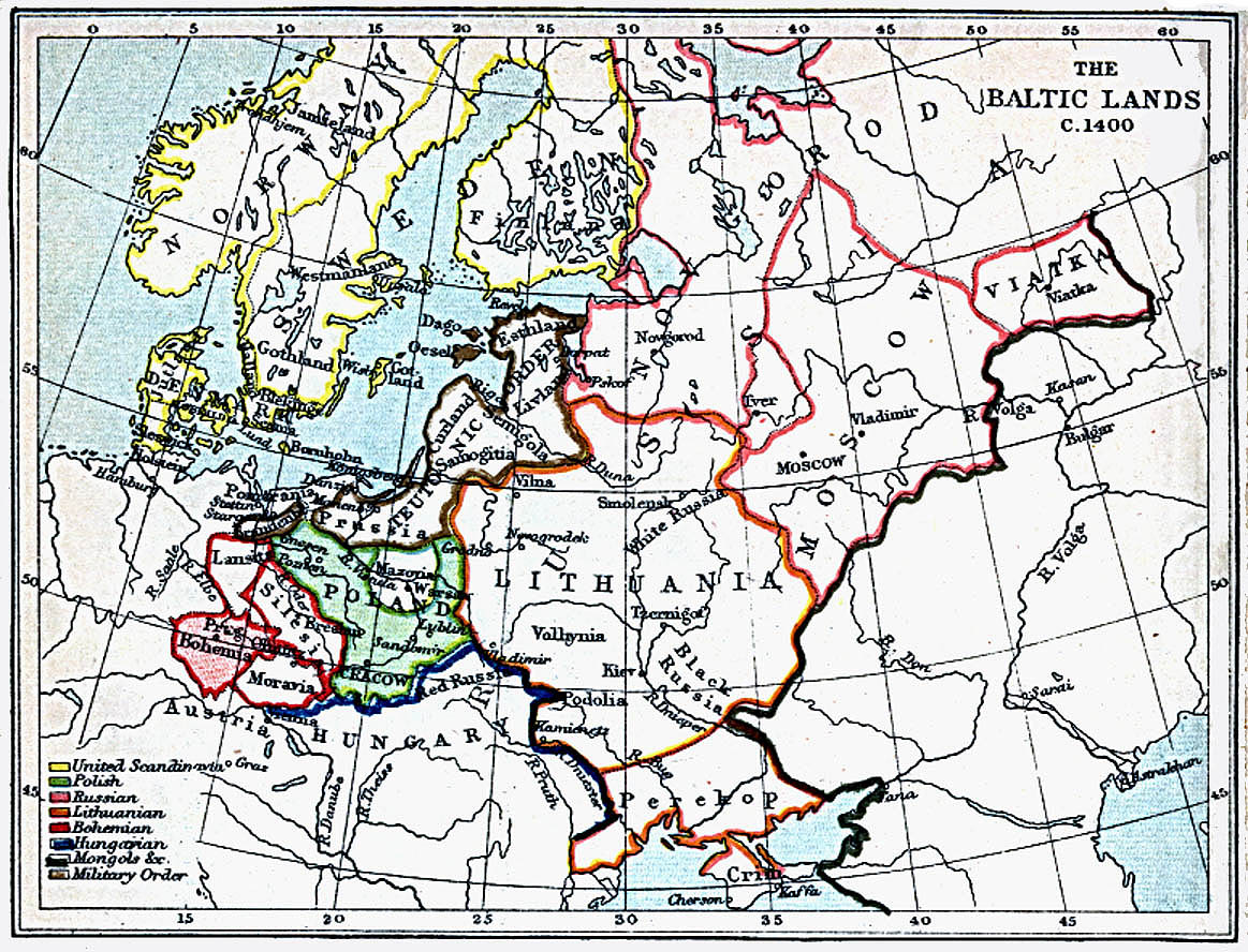
1400 "Baltic Lands." From
the 1903 "Atlas to Freeman's
Historical Geography"
the 1903 "Atlas to Freeman's
Historical Geography"

1478 "Baltic Lands." From
the 1903 "Atlas to Freeman's
Historical Geography"
the 1903 "Atlas to Freeman's
Historical Geography"

1563 "Baltic Lands." From
the 1903 "Atlas to Freeman's
Historical Geography"
the 1903 "Atlas to Freeman's
Historical Geography"

1617 "Baltic Lands." From
the 1903 "Atlas to Freeman's
Historical Geography"
the 1903 "Atlas to Freeman's
Historical Geography"
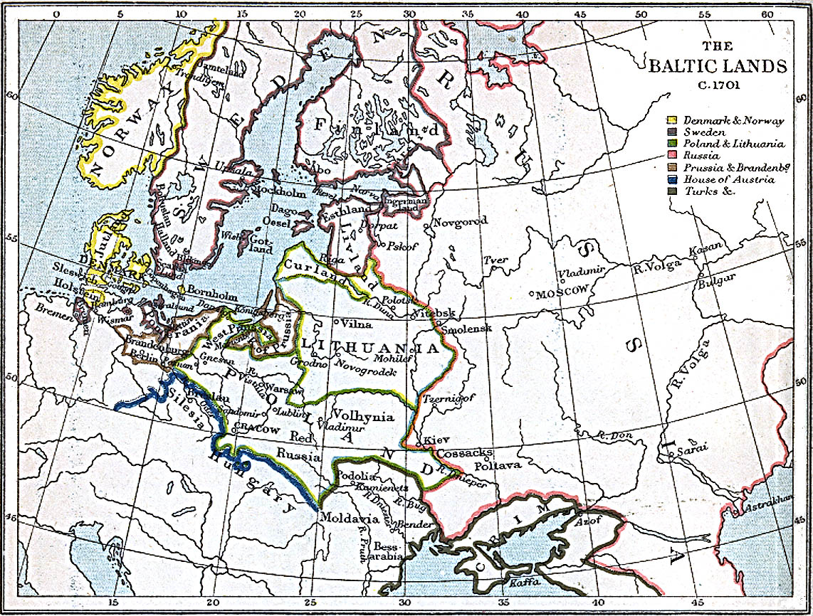
1701 "Baltic Lands." From
the 1903 "Atlas to Freeman's
Historical Geography"
the 1903 "Atlas to Freeman's
Historical Geography"

1772 "Baltic Lands." From
the 1903 "Atlas to Freeman's
Historical Geography"
the 1903 "Atlas to Freeman's
Historical Geography"

1795 "Baltic Lands." From
the 1903 "Atlas to Freeman's
Historical Geography"
the 1903 "Atlas to Freeman's
Historical Geography"
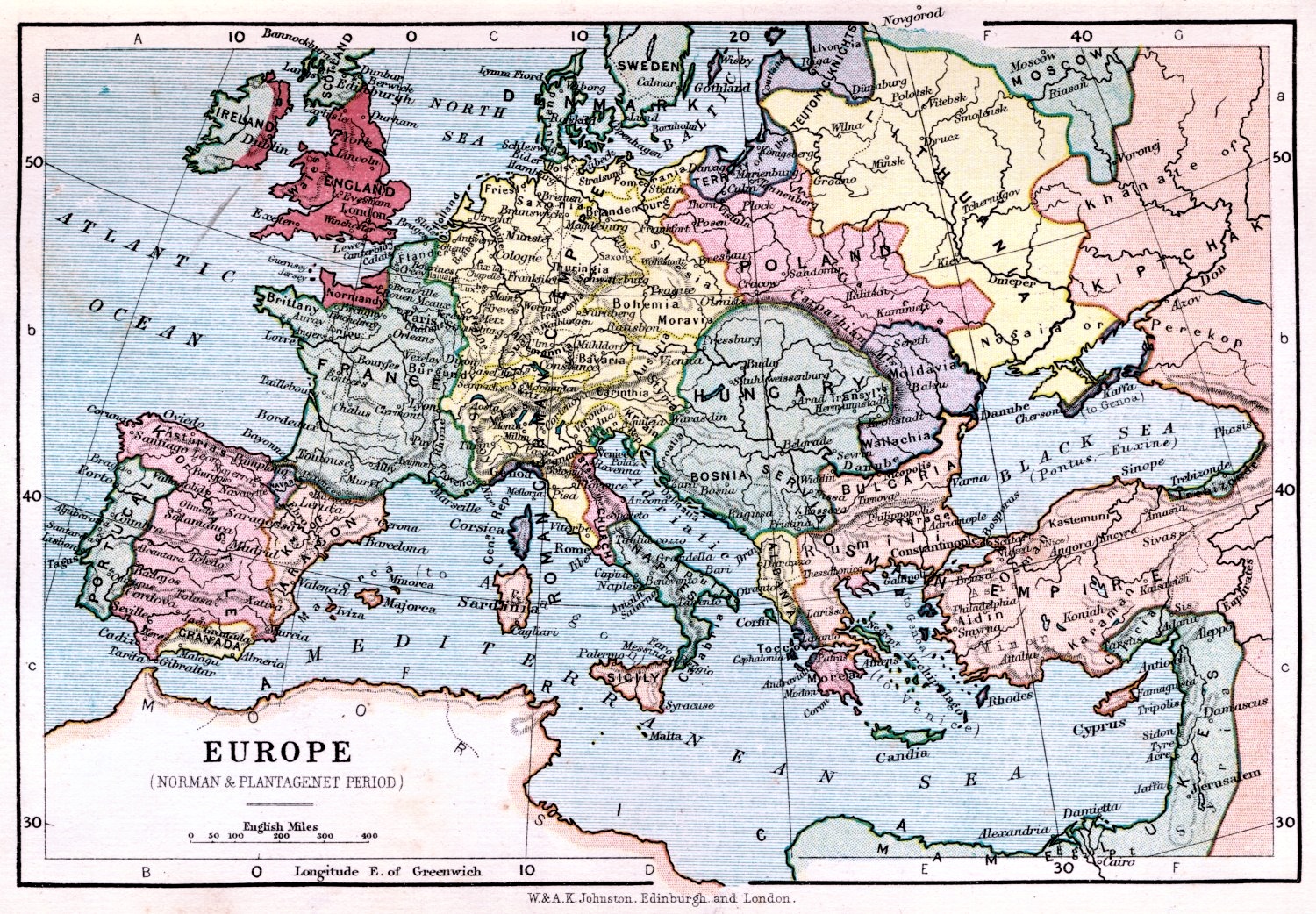
1066-1509 Johnston:
"Europe: Norman &
Plantagenet Period,"
1899. Notice the size and
boundaries of Lithuania.
From etc.usf.edu/maps
"Europe: Norman &
Plantagenet Period,"
1899. Notice the size and
boundaries of Lithuania.
From etc.usf.edu/maps

1095-1270 Victor Drury:
"Europe during the
Crusades," from his 1912
"History of the World."
Lithuania virtually
disappears in this version.
From www.etc.usf.edu/maps
"Europe during the
Crusades," from his 1912
"History of the World."
Lithuania virtually
disappears in this version.
From www.etc.usf.edu/maps

14th Century Karl von
Spruner: "Nord- und Ost-
EUROPA im Anfange des
XIVten Jahr- hunderts,"
from "von Spruner's
School Atlas," published
by Gotha Justas Perthes
1860. From buybali on eBay
Spruner: "Nord- und Ost-
EUROPA im Anfange des
XIVten Jahr- hunderts,"
from "von Spruner's
School Atlas," published
by Gotha Justas Perthes
1860. From buybali on eBay
1809 "Baltic Lands." From
the 1903 "Atlas to Freeman's
Historical Geography"
the 1903 "Atlas to Freeman's
Historical Geography"
Nov. 1942 - May 1945:
"Der Zweite Weltkreig in
Europe," showing Allied
advances against the
Germans.
"Der Zweite Weltkreig in
Europe," showing Allied
advances against the
Germans.


1539 Olaus Magnus: "Carta marina,"
translated caption: "A marine map and
Description of the Northern Lands and of
their Marvels, most carefull drawn up at
Venice in the year 1539." From the James
Ford Bell Library, Univ. of Minnesota
translated caption: "A marine map and
Description of the Northern Lands and of
their Marvels, most carefull drawn up at
Venice in the year 1539." From the James
Ford Bell Library, Univ. of Minnesota

1350 Spruner- Menke:
"EUROPA UM DIE MITTE
DES VIERZEHNTEN
JAHRHUN- DERTS" (Europe
in the middle of the 14th
century) From "Hand-Atlas
für die Geschichte des
Mittel-alters ..." From
www.maproom.org
"EUROPA UM DIE MITTE
DES VIERZEHNTEN
JAHRHUN- DERTS" (Europe
in the middle of the 14th
century) From "Hand-Atlas
für die Geschichte des
Mittel-alters ..." From
www.maproom.org


1492-1618 Spruner-Menke:
"EUROPA während des Zeitraums
der Reformation und der
Übermacht des Hauses Habsburg"
("Europe during the Reformation and
the supremacy of the House of
Habsburg"), from "Hand-Atlas für
die Geschichte des Mittel-alters ..."
From www.maproom.org
"EUROPA während des Zeitraums
der Reformation und der
Übermacht des Hauses Habsburg"
("Europe during the Reformation and
the supremacy of the House of
Habsburg"), from "Hand-Atlas für
die Geschichte des Mittel-alters ..."
From www.maproom.org

Sebastian Münster: "Europa Regina
(Queen of the World)." First drawn
1537 by Jonannes Bucius, versions
appeared in several editions of
Münster's "Cosmography."
(Queen of the World)." First drawn
1537 by Jonannes Bucius, versions
appeared in several editions of
Münster's "Cosmography."


1581 Heinrich Bünting:
"Die ganze Welt in einem
Kleberblat" (The Whole
World in the form of a
Clover-leaf), Hanover,
from his "Itinerarium
sacrae scripturae." From
www.karty.by
"Die ganze Welt in einem
Kleberblat" (The Whole
World in the form of a
Clover-leaf), Hanover,
from his "Itinerarium
sacrae scripturae." From
www.karty.by
1593 Gerard de Jode: "SEPTENTRIONALIV REGIONIONVM SVETIÆ GOTHIÆ
NORVEGIÆ DANIÆ et terrarum adicetium recens exacta que descriptio per Liuinum
algoet Auctorem Gerardus de Jode execudebat," Antwerp, 19.5 x 14.5 inches, in three
versions. The Dutch engravers were the famous Joannes and Lucas van Deutecum.
First published 1578, De Jode's "Speculum Orbis Terrae atlas was, while technically
superior to the work of Ortelius, a commercial failure, thanks to Ortelius' blocking a
"privilege" for publication for nearly ten years. All three maps are from the second,
expanded edition of the atlas.


1595 Abraham Ortelius:
"SEPTENTRIO- NALIUM
REGIONUM DESCRIP.," Antwerp,
36 x 48.7 cm. First published
1570. Also a DETAIL image. From
www.helmink.com
"SEPTENTRIO- NALIUM
REGIONUM DESCRIP.," Antwerp,
36 x 48.7 cm. First published
1570. Also a DETAIL image. From
www.helmink.com

1628 Sebastian
Munster: "Europa nach
gelegenheit," from
"Cosmographia, Das ist
Beschreibung der ganzen
Welt," Basel. From
www.nic.funet.fi
Munster: "Europa nach
gelegenheit," from
"Cosmographia, Das ist
Beschreibung der ganzen
Welt," Basel. From
www.nic.funet.fi
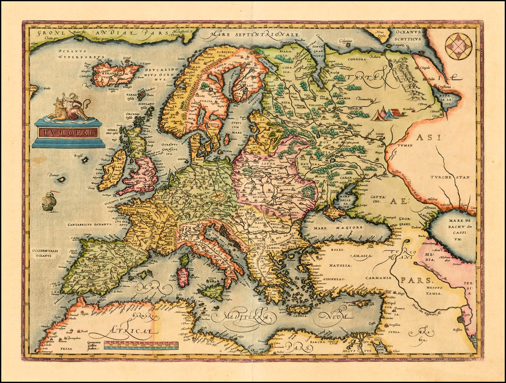
1603 Abraham Ortelius:
"EVROPAE," Antwerp,
2nd edition, first issued
1584, distinguished
from earlier editions by
cursive lettering of
"Africae Pars." From
www.raremaps.com
"EVROPAE," Antwerp,
2nd edition, first issued
1584, distinguished
from earlier editions by
cursive lettering of
"Africae Pars." From
www.raremaps.com

c. 1630 Willem Janszoon Blaeu: "Europa recens
descripta . . ." Amsterdam, 22 x 16 inches, in two
versions with wildly different colored boundaries for
Lithuania, the second showing Lithuania as part of
Russia. The map shows nine European cities across the
top and local costumes along the sides, including those
of the "Poloni."
descripta . . ." Amsterdam, 22 x 16 inches, in two
versions with wildly different colored boundaries for
Lithuania, the second showing Lithuania as part of
Russia. The map shows nine European cities across the
top and local costumes along the sides, including those
of the "Poloni."

Heinrich Bunting: "EVROPA PRIMA PARS TERRAE IN
FORMA VIRGINIS ...." Hanover, 17 x 12 inches.
FORMA VIRGINIS ...." Hanover, 17 x 12 inches.
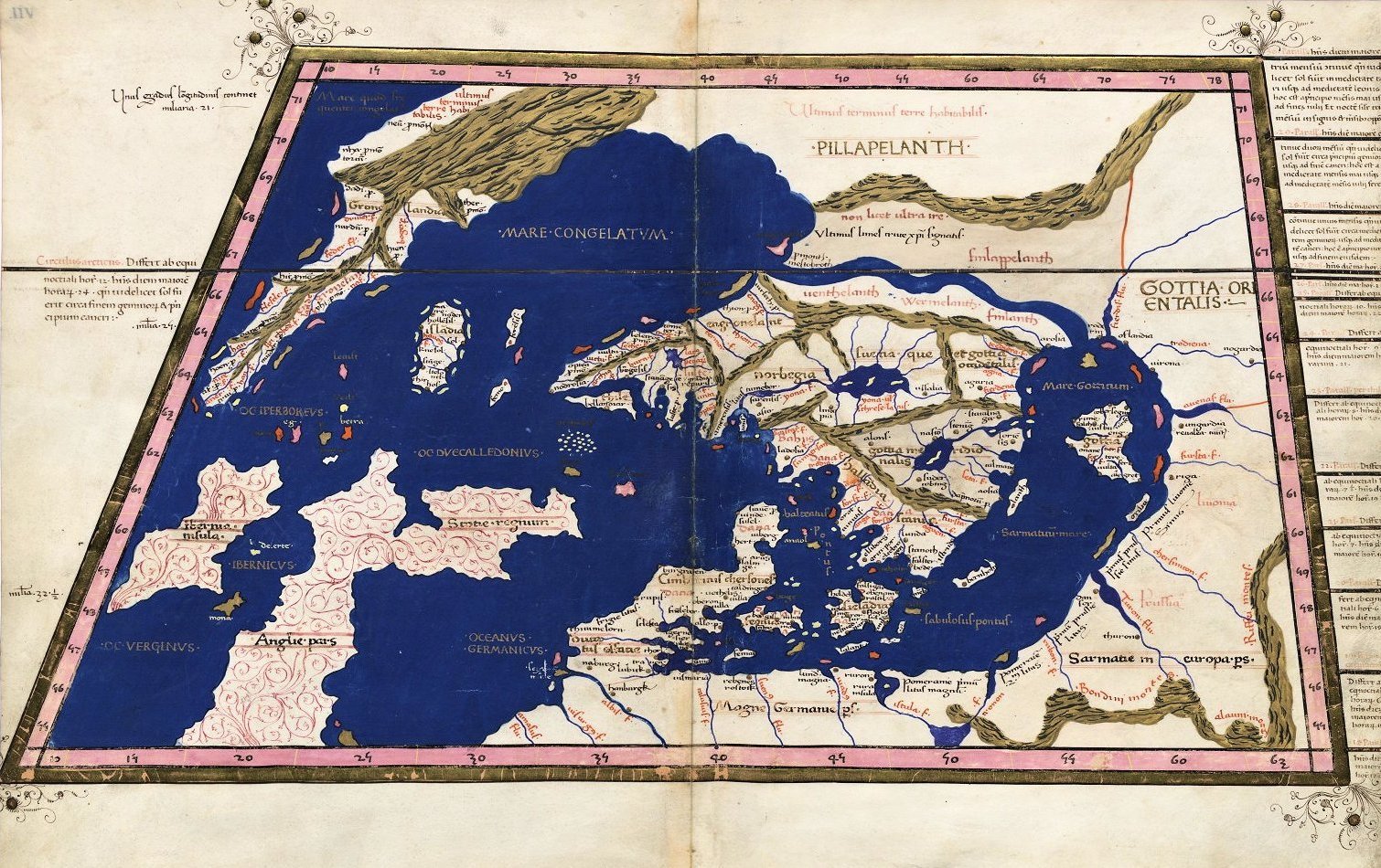
1478 After Claudius
Ptolemy. From a
"Geographia" with maps
engraved by Taddeo
Crivelli -- published in
Bologna. Note "Riga," and
"Livonia."
Ptolemy. From a
"Geographia" with maps
engraved by Taddeo
Crivelli -- published in
Bologna. Note "Riga," and
"Livonia."
1482 Francesco Nicolo di Berlinghieri: "TABVLA
OCTAVA DE EUROPA," Florence, 22.5 x 17.5 inches,
printed with two woodblocks on one sheet, in two
versions from his "Septe Giornate della Geographia di
Francesco Berlinghieri" (The Seven Days of Geography).
Berlinghieri's map is the third map of the region
(pre-dated by 1477 and 1478 editions), but his map is
important because: 1. It is based on the projections of
Marinus of Tyre, a second century AD Greek
geographer/cartographer/mathematician, the founder
of mathematical geography, a system which would have
been employed by Claudius Ptolemy. 2. It is the first
printed map of the region to utilize a style notably
different from the Nicholas Germanicus model and to
adopt a different means for projecting the printed
landmasses represented on the maps. 3. It was engraved
by Niccolò Tedesco, a German printer. 4. It has
rectangular borders rather than the trapezoidal borders
employed in the earlier editions. From Barry Lawrence
Ruderman, www.raremaps.com


1493 Hartmann Schedel (publisher) - Hieronymus
Münzer (designer): "Europa," Nuremburg, 23 x 15.5
inches, from the Latin edition of "Liber Chronicum," in
uncolored and colored versions. Note the labelling of
"POLONIA," "LITTAW," the town of "Melbing" (Memel?),
LIVONIA" and Riga.
Münzer (designer): "Europa," Nuremburg, 23 x 15.5
inches, from the Latin edition of "Liber Chronicum," in
uncolored and colored versions. Note the labelling of
"POLONIA," "LITTAW," the town of "Melbing" (Memel?),
LIVONIA" and Riga.

1520 Abraham Ortelius: "
TABVLA. MODERNA.
SARMATIE...POLONIE..."
From the National Museum of
Lithuania:
http://www.lnm.lt/en/
TABVLA. MODERNA.
SARMATIE...POLONIE..."
From the National Museum of
Lithuania:
http://www.lnm.lt/en/


Martin Waldseemüller (mapmaker) - Laurent Fries
(publisher): "SARMATIA," from Fries' "Ptolemy's
Geographia," published in four editions from 1522 -
1541. Together with Johannes Grüninger, Fries issued
the two editions of 1522 and 1525 at Johann Koberger in
Strasbourg. The third edition with smaller maps
appeared after the death of Grüninger and Fries in Lyon
1535 with Melchior and Gaspar Trechsel. The last
edition was printed in Vienne 1541 by Gaspar Trechsel.


Sebastian Münster: "EVROPA PRIMA NOVA
TABVLA,"13.5 x 10 inches / 33 x 27 cm, Basle, in both
the first, 1540 edition on the left, and the 1542 version
on the right, both woodcuts from his "Geographia," the
first atlas to include maps of every continent.
TABVLA,"13.5 x 10 inches / 33 x 27 cm, Basle, in both
the first, 1540 edition on the left, and the 1542 version
on the right, both woodcuts from his "Geographia," the
first atlas to include maps of every continent.
Sebastian Münster: "TABVLA EVROPÆ VIII," Basel, 10.9 x 13.3 inches, text in Latin,
from "Geographia Universalis, Vetus et Nova, complectens Cladii Ptolemaei
Alexandrini enarrationis libros VIII," in three versions (first edition 1540), published
by Heinrich Petri. The same 21 words are listed in each version, but the list has been
reset: 1542's "Badatiu" has become "Badatium" in the 1545 and 1552 versions .


| 1542 www.sanderusmaps.com |

1548 Giacomo Gastaldi:
"TABVLA EVROPÆ VIII,"
after Ptolemy
"TABVLA EVROPÆ VIII,"
after Ptolemy
1548 Johann Stumpf:
"Europa," 15 x 12 inches,
Zurich, oriented with
south at the top, as was
the Arabic custom, from
his "Landtaflen." From
wikimedia
"Europa," 15 x 12 inches,
Zurich, oriented with
south at the top, as was
the Arabic custom, from
his "Landtaflen." From
wikimedia

1550 Giacomo Gastaldi:
"Desciptione de la
Moscovia..." Venice, 15.5 x
10.5 inches, based on the
work of Baron Sigismund
von Herberstein, who had
visited Moscow twice as
Emperor Maximillian I's
ambassador to Russia.
From www.raremaps.com
"Desciptione de la
Moscovia..." Venice, 15.5 x
10.5 inches, based on the
work of Baron Sigismund
von Herberstein, who had
visited Moscow twice as
Emperor Maximillian I's
ambassador to Russia.
From www.raremaps.com

Sebastian Münster: "MODERNA EVROPÆ DESCRIPTIO,"
Basle, 13.5 x 10 inches, in colored and uncolored
versions from his "Geographia," first published in 1540.
Compare these maps with the 1540 and 1542 versions.
Basle, 13.5 x 10 inches, in colored and uncolored
versions from his "Geographia," first published in 1540.
Compare these maps with the 1540 and 1542 versions.
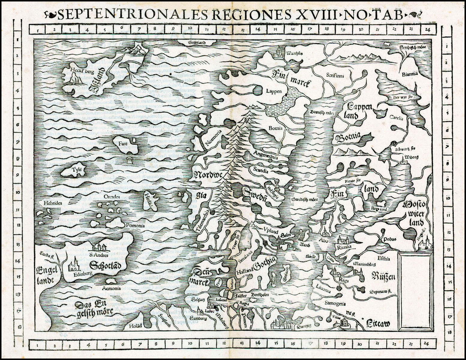
1552 Sebastian Münster:
"SEPTENTRIONALES
REGIONES XVIII NO TAB."
"SEPTENTRIONALES
REGIONES XVIII NO TAB."

Girolamo Ruscelli: "EVROPÆ TABVLA VIII," Venice, 10.5 by 7.5 inches, in five versions from editions of his "Ptolemaeus La Geografia," which
published new (Tabula Nova) maps along with Ptolemy's 2nd century descriptions. The 1574 edition of the atlas was published by G. Ziletti. This
Ptolemaic rendition of central Europe is fairly recognisable to modern eyes with an enlarged Sea of Azov dominating the south east. The western
edge of the map is marked by the Vistula river.


1578 Gerard Mercator:
"Europa Octava tabula
EUR VIII TAB" with no
cartouche
"Europa Octava tabula
EUR VIII TAB" with no
cartouche
1597 Giovanni Antonio
Magini: "TABVLA
EVROPAE VIII." From
Magini's "Geographia,"
based upon Ptolemy. From
www.raremaps.com
Magini: "TABVLA
EVROPAE VIII." From
Magini's "Geographia,"
based upon Ptolemy. From
www.raremaps.com


1730 Johann Homann:
"SCANDINAVIA," Nurem-
burg, 19 x 22 inches.
Engraved before 1715,
because it lacks a "cum
privilegio." From
www.geographicus.com
"SCANDINAVIA," Nurem-
burg, 19 x 22 inches.
Engraved before 1715,
because it lacks a "cum
privilegio." From
www.geographicus.com

1891 Stieler: "OST-
EUROPA No. 3." From
the 1888-91 eighth
edition, of "Hand-Atlas
über alle Theile der Erde
und über das Weltge-
bäude" (Handy atlas of
all parts of the world and
of the universe), . (See
the 1862 edition.) (AK)
EUROPA No. 3." From
the 1888-91 eighth
edition, of "Hand-Atlas
über alle Theile der Erde
und über das Weltge-
bäude" (Handy atlas of
all parts of the world and
of the universe), . (See
the 1862 edition.) (AK)
1917: "Germany's Future,"
according to an officially
published pamphlet --
with annexed eastern
territories looking a lot like
the old Polish- Lithuanian
Commonwealth.
according to an officially
published pamphlet --
with annexed eastern
territories looking a lot like
the old Polish- Lithuanian
Commonwealth.


1919 "NOWA EUROPA W
ROKU 1919," Krakow-
Warszawa. Also a DETAIL
image. (AK)
ROKU 1919," Krakow-
Warszawa. Also a DETAIL
image. (AK)


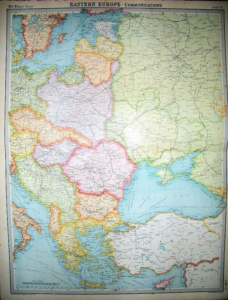
1921 "EASTERN
EUROPE - COMMUN-
ICA TIONS," from
"The Times Survey
Atlas of the World,"
London. (AK)
EUROPE - COMMUN-
ICA TIONS," from
"The Times Survey
Atlas of the World,"
London. (AK)


1646 John Speed:
"EUROPA," London, 5 x
3.5 inches, from his
scarce miniature atlas:
"Epitome." From
www.raremaps.com
"EUROPA," London, 5 x
3.5 inches, from his
scarce miniature atlas:
"Epitome." From
www.raremaps.com

1648- 1700 "EUROPA," from the
1880 Spruner- Menke Hand-Atlas.
Also a DETAIL image. From
www.maproom.org
1880 Spruner- Menke Hand-Atlas.
Also a DETAIL image. From
www.maproom.org

1643 Jean Boisseau:
"Nouvelle Description de
L'Europe, Paris, c1657
From Boisseau's Tresor
des carte Geographiques."
From www.raremaps.com
"Nouvelle Description de
L'Europe, Paris, c1657
From Boisseau's Tresor
des carte Geographiques."
From www.raremaps.com

1669 Willem Janzsoon
Blaeu - Giacomo
Giovanni Rossi: "Totius
Europæ Nova Et Exacta
Tabula ...," Rome, 35 x
22.5 inches, in a
four-sheet map. From
www.raremaps.com
Blaeu - Giacomo
Giovanni Rossi: "Totius
Europæ Nova Et Exacta
Tabula ...," Rome, 35 x
22.5 inches, in a
four-sheet map. From
www.raremaps.com
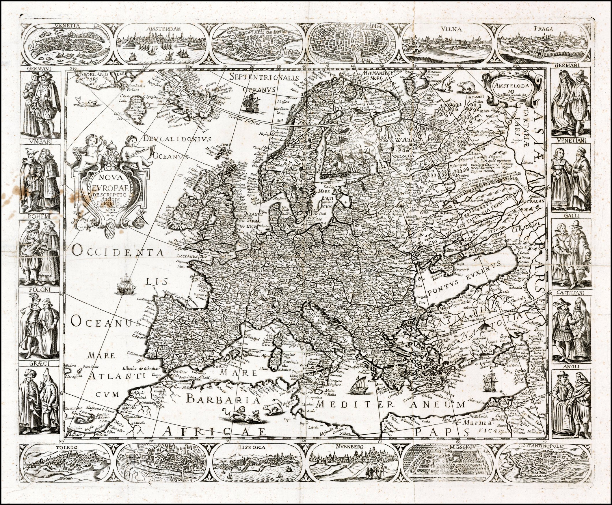
1670 Francesco Sabatini
- Pietro Todeschi: "Nova
Europae Descriptio
Auctore I. Hondio. Pietro
Todeschi Scul.," 21.5 x
17.5 inches, with 10 coty
views and 12 vignettes of
national dress. From
www.raremaps.com
- Pietro Todeschi: "Nova
Europae Descriptio
Auctore I. Hondio. Pietro
Todeschi Scul.," 21.5 x
17.5 inches, with 10 coty
views and 12 vignettes of
national dress. From
www.raremaps.com

1717 Nicolas de Fer:
"L'Europe Suivant les
Nouvelles Observations,"
Paris, 13 x 9 inches, in
the third state from his
"L'Atlas Curieux ou le
Monde." From
www.raremaps.com
"L'Europe Suivant les
Nouvelles Observations,"
Paris, 13 x 9 inches, in
the third state from his
"L'Atlas Curieux ou le
Monde." From
www.raremaps.com

1740 John Bartholomew:
"EUROPE," Edinburgh,
8.5 x 7 inch lithograph
from an 1896 atlas. From
york on eBay
"EUROPE," Edinburgh,
8.5 x 7 inch lithograph
from an 1896 atlas. From
york on eBay

"1740 EUROPA," from the 1880
Spruner- Menke Hand-Atlas. With
a DETAIL image. From
www.maproom.org
Spruner- Menke Hand-Atlas. With
a DETAIL image. From
www.maproom.org

1810 "EUROPA zur Zeit
NAPOLEON'S I," from the 1880
Spruner-Menke Hand- Atlas. With
a DETAIL image. From
www.maproom.org
NAPOLEON'S I," from the 1880
Spruner-Menke Hand- Atlas. With
a DETAIL image. From
www.maproom.org

1815 "EUROPA nach dem Wiener
Congress," from the 1880 Spruner-
Menke Hand-Atlas. With a DETAIL
image. From www.maproom.org
Congress," from the 1880 Spruner-
Menke Hand-Atlas. With a DETAIL
image. From www.maproom.org

1765 A. van Krevelt:
"NIEUWE GENERALE
KAART VAN EUROPA,"
Amsterdam. From
www.orteliusmaps.org
"NIEUWE GENERALE
KAART VAN EUROPA,"
Amsterdam. From
www.orteliusmaps.org

1708 Charles Price (car-
tographer) - John Senex
(engraver): "Europe Cor-
rected from the Observa-
tions Commu icated to the
Royal Society at London,"
From www.raremaps.com
tographer) - John Senex
(engraver): "Europe Cor-
rected from the Observa-
tions Commu icated to the
Royal Society at London,"
From www.raremaps.com

1919 "Europe," from the
London Geographical
Institute, published
1920 in "The People's
Atlas."
London Geographical
Institute, published
1920 in "The People's
Atlas."

1598 Abraham Ortelius:
"EUROPA," Brescia, 5 x 4
inches, from Marchetti's
edition of Ortelius'
"Epitome." From
www.raremaps.com
"EUROPA," Brescia, 5 x 4
inches, from Marchetti's
edition of Ortelius'
"Epitome." From
www.raremaps.com
1740 Herman Moll:
"EUROPE," London, 8 x
10 inches, from his
"Atlas Minor, published
1729-40. From
jpmaps.co.uk
"EUROPE," London, 8 x
10 inches, from his
"Atlas Minor, published
1729-40. From
jpmaps.co.uk


1620 Jodocus Hondius: "NOVA EUROPÆ," Amsterdam,
15 x 19 .75 inches, in two versions. Hondius' second map
of Europe, first issued in 1606. Nova Zembla is shown
shortly after Barentsz Voyages.
15 x 19 .75 inches, in two versions. Hondius' second map
of Europe, first issued in 1606. Nova Zembla is shown
shortly after Barentsz Voyages.
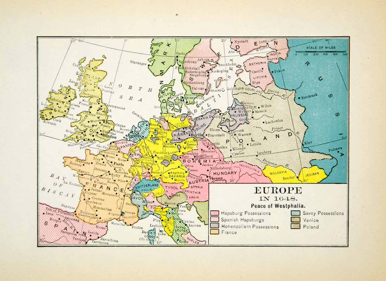
1648 (Anon.) "Europe;
the Peace of Westphalia,"
6.5 x 5 inches, published
1912. From
www.periodpaper.com
the Peace of Westphalia,"
6.5 x 5 inches, published
1912. From
www.periodpaper.com

1682 (Anon.) "North-
eastern Europe in the
time of Peter the Great,"
published 1907. From
www.periodpaper.com
eastern Europe in the
time of Peter the Great,"
published 1907. From
www.periodpaper.com

1891 "Europe," from
Rand McNally's "Indexed
Atlas of the World." From
the U.S. Librry of Congress,
Geography and Map Division.
Rand McNally's "Indexed
Atlas of the World." From
the U.S. Librry of Congress,
Geography and Map Division.

C. Colbeck: "Europe during
the 15th Century," from
1905's " Public Schools
Historical Atlas." Note:
"Countries left uncoloured
[like Lithuania] were
inhabited by Mohamme-
dans and other non-
Christians." From
http://www.lib.utexas.ed
the 15th Century," from
1905's " Public Schools
Historical Atlas." Note:
"Countries left uncoloured
[like Lithuania] were
inhabited by Mohamme-
dans and other non-
Christians." From
http://www.lib.utexas.ed

1560 William Shepherd:
"Europe," from his 1926
"Historical Atlas." From
http://www.lib.utexas.edu/
maps/historical/history_
europe.htm
"Europe," from his 1926
"Historical Atlas." From
http://www.lib.utexas.edu/
maps/historical/history_
europe.htm

1713 Herman Moll:
"EUROPE after the
TREATY of UTRECHT,"
10 x 7.5 inches,
reprinted 1944. From
www.periodpaper.com
"EUROPE after the
TREATY of UTRECHT,"
10 x 7.5 inches,
reprinted 1944. From
www.periodpaper.com

c. 1700 Robin Redcoat:
"Europe." from WkiCommons
"Europe." from WkiCommons

William R. Shepherd:
"Europe about 1740," from
his 1926 "Historical Atlas."
From http://www.lib.utexas.edu/
maps/historical/history_europe
"Europe about 1740," from
his 1926 "Historical Atlas."
From http://www.lib.utexas.edu/
maps/historical/history_europe

1782 August Crome: "Neue Carte
von Europa, [detailing Commercial
and Industrial Production]," 20.3 x
17.3 inches. Tables list products
made by each country; a key shows
where those products originate.
From www.oldworldauctions.com
von Europa, [detailing Commercial
and Industrial Production]," 20.3 x
17.3 inches. Tables list products
made by each country; a key shows
where those products originate.
From www.oldworldauctions.com

c. 1815 (Anon.):
"EUROPA," Germany, 7
5/8 x 6 3/8. From
antiquemapsprints
"EUROPA," Germany, 7
5/8 x 6 3/8. From
antiquemapsprints

1650-59 Nicolas Sanson:
"l'EVROPE," Paris, 15.7 x 22.0
inches, published by Pierre
Mariette. Also a DETAIL image of
"Pologne," and "Litvania." From
www.swaen.com
"l'EVROPE," Paris, 15.7 x 22.0
inches, published by Pierre
Mariette. Also a DETAIL image of
"Pologne," and "Litvania." From
www.swaen.com

1640 Matthaus
Merian: "EVROPA Nova
Delineatio," Frankfurt,
14 x 11 inches, after
Blaeu. From
www.raremaps.com
Merian: "EVROPA Nova
Delineatio," Frankfurt,
14 x 11 inches, after
Blaeu. From
www.raremaps.com

1922 London Geograph-
ical Institute: "Europe's
overland, sea commun-
ications," 50 x 70 cm., at
1:20 000 000, from the
"New Mercantile Marine
Atlas," by Hammond
and George Philip & Son.
From www.davidrumsey.com
ical Institute: "Europe's
overland, sea commun-
ications," 50 x 70 cm., at
1:20 000 000, from the
"New Mercantile Marine
Atlas," by Hammond
and George Philip & Son.
From www.davidrumsey.com

1922 J.G. Bartholomew: "Europe -
Political," London, 43 x 56 cm., at 1:10
000 000, published in "Times Survey
Atlas of the World." From
www.davidrumsey.com
Political," London, 43 x 56 cm., at 1:10
000 000, published in "Times Survey
Atlas of the World." From
www.davidrumsey.com

1619 Samuel Purchas -
Jodocus Hondius:
"Evropa...," London, 19 x
15 inches, from his
"Purchas, his Pilgrim..."
From www.raremaps.com
Jodocus Hondius:
"Evropa...," London, 19 x
15 inches, from his
"Purchas, his Pilgrim..."
From www.raremaps.com

1770 Thomas Kitchin:
"EUROPE from the best
Authorities," London.
From Modern Gazeteer
"EUROPE from the best
Authorities," London.
From Modern Gazeteer

1804 (dated 1795) Jean
Baptiste Bourguignon
d'Anville (cartographer) -
Thomas Kitchin (engraver)
- Robert Laurie & James
Whittle (publishers:
"Europe," London, 104 x
123 cm. at 1:4 800 000.
From www.davidrumsey.com
Baptiste Bourguignon
d'Anville (cartographer) -
Thomas Kitchin (engraver)
- Robert Laurie & James
Whittle (publishers:
"Europe," London, 104 x
123 cm. at 1:4 800 000.
From www.davidrumsey.com

1680-90 Nicolas Visscher:
"Europa delineata et
recens edita per Nicolaum
Visscher..," Amsterdam,
43.5 x 54 cm. From
www.bergbook.com
"Europa delineata et
recens edita per Nicolaum
Visscher..," Amsterdam,
43.5 x 54 cm. From
www.bergbook.com

1745 Phillip Buache -
Guillaume De L'Isle: "Carte
D' Europe..." Paris, 50.5 x
62.5 cm . Buache updated
De L'Isle's 1724 map. From
www.bergbook.com
Guillaume De L'Isle: "Carte
D' Europe..." Paris, 50.5 x
62.5 cm . Buache updated
De L'Isle's 1724 map. From
www.bergbook.com
| c. 1550 www.raremaps.com |


1789 Adrien Hubert Brue -
Pierre Emile Levasseur:
"Carte Generale L'Europe
en 1789," Paris, 38 x 52
cm, from Brue's 1875 (and
last) edition of "Atlas
Universel De Geographie
Physique, Politique,
Ancienne Et Moderne...,"
first published 1822. From
www.davidrumsey.com
Pierre Emile Levasseur:
"Carte Generale L'Europe
en 1789," Paris, 38 x 52
cm, from Brue's 1875 (and
last) edition of "Atlas
Universel De Geographie
Physique, Politique,
Ancienne Et Moderne...,"
first published 1822. From
www.davidrumsey.com
1789 "Europe in 1789,"
10 x 8 inches, published
1935 by Houghton
Miflin. From
www.periodpaper.com
10 x 8 inches, published
1935 by Houghton
Miflin. From
www.periodpaper.com

1791 Franz Johann Josef
von Reilly: "Das Östliche
und Nördliche Europa..."
Vienna, 23,5 x 36 cm.
From his atlas 'Schau-
platzes der fünf Theile
der Welt...' From
www.bergbook.com
von Reilly: "Das Östliche
und Nördliche Europa..."
Vienna, 23,5 x 36 cm.
From his atlas 'Schau-
platzes der fünf Theile
der Welt...' From
www.bergbook.com

1744 Tobias Lotter: "Eu-
ropa religionis Christ-
ianae morum et pacis..."
(Europe: Christian morals
and a civilization of peace
and war) Augsburg. From
ruggis on eBay
ropa religionis Christ-
ianae morum et pacis..."
(Europe: Christian morals
and a civilization of peace
and war) Augsburg. From
ruggis on eBay

c. 1594 Giuseppe
Rosaccio: ("Europe"),
Venice, 6 x 5.
5 inches, showing
"LITVANIA," and
"LIVONIA." From
www.raremaps.com
Rosaccio: ("Europe"),
Venice, 6 x 5.
5 inches, showing
"LITVANIA," and
"LIVONIA." From
www.raremaps.com

1772 Thomas Jeffreys:
"EUROPE," London. 8 x
10.5 inches. "Poland's"
eastern boundary goes
right up to Smolensk. From
greypilgrimbooksandmaps
"EUROPE," London. 8 x
10.5 inches. "Poland's"
eastern boundary goes
right up to Smolensk. From
greypilgrimbooksandmaps
| 1560 bertius on eBay |
1578 Gerard Mercator - after Claudius Ptolemy: "Europe
VIII, SARMATIA," Amsterdam, 19 x 13.5 inches / 37 x 51
cm., in two versions based on the writings of Prolemy.
Looking for familiar names, even in Latin? Look at the
"c1200 Baltic Tribes" at the "MapsHistoricalUpTo 1795"
page, and see "Galindians and Sudovians."
VIII, SARMATIA," Amsterdam, 19 x 13.5 inches / 37 x 51
cm., in two versions based on the writings of Prolemy.
Looking for familiar names, even in Latin? Look at the
"c1200 Baltic Tribes" at the "MapsHistoricalUpTo 1795"
page, and see "Galindians and Sudovians."


1602 Hondius: "EVROPA,"
engraving by I. le Clerc, with a
DETAIL image. From the National
Library of Russia: http://leb.nlr.ru/edoc
engraving by I. le Clerc, with a
DETAIL image. From the National
Library of Russia: http://leb.nlr.ru/edoc
1787 Thomas Kitchin:
"EUROPE Divided into its
EMPIRES, KINGDOMS,
STATES, REPUBLICS & C..,"
London, 100 x 100 cm,
showing boundaries after
the First Partition. From
www.davidrumsey.com
"EUROPE Divided into its
EMPIRES, KINGDOMS,
STATES, REPUBLICS & C..,"
London, 100 x 100 cm,
showing boundaries after
the First Partition. From
www.davidrumsey.com

1700 Guillaume de l'Isle: "L'Europe...,"
Paris. Showing, in a DETAIL image,
l"Lithuanie" within "Pologne," occupying
lands that would often later be claimed
as Historic Belarus. From the National
Library of Russia: http://leb.nlr.ru/collections
Paris. Showing, in a DETAIL image,
l"Lithuanie" within "Pologne," occupying
lands that would often later be claimed
as Historic Belarus. From the National
Library of Russia: http://leb.nlr.ru/collections

1712 Edward Wells: "A
New Map of Europe
according to the Present
General Divisions and
Names," Oxford, 20 x 14.5
inches. By 1712, Estonia
and Livonia were Russian.
From www.raremaps.com
New Map of Europe
according to the Present
General Divisions and
Names," Oxford, 20 x 14.5
inches. By 1712, Estonia
and Livonia were Russian.
From www.raremaps.com

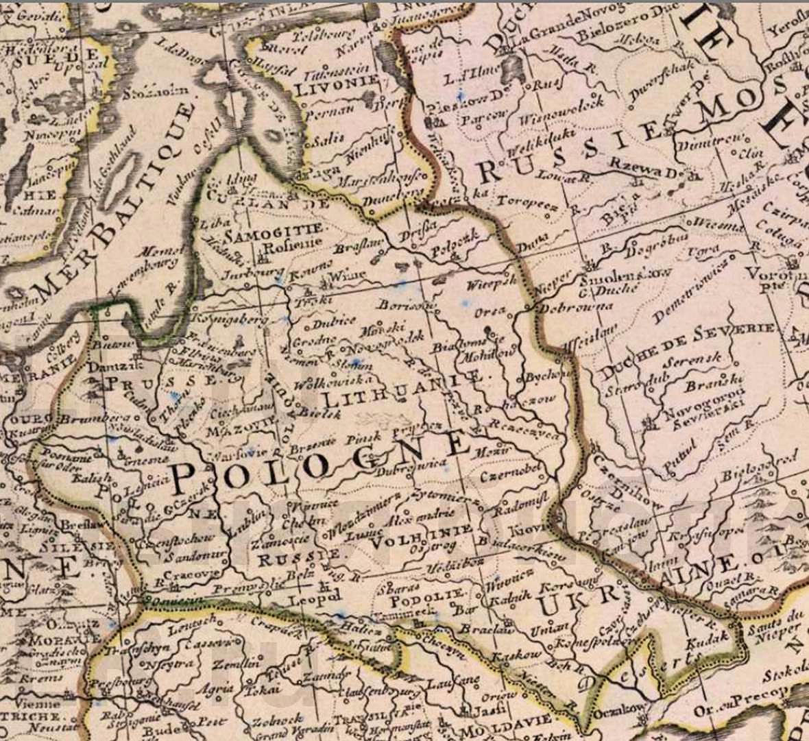
1922 J.M Bazewicz: "Mapa Europy,"
Warsaw, with an unusual boundary for
newly-independent Lithuania, and a
shaded extension of Poland's new
boundaries, showing the extent of the
Polish-Lithuanian Commonwealth in
1772 -- but labeling the area, translated,
as "Polsih Lands in 1772."From
www.mapywig.org
Warsaw, with an unusual boundary for
newly-independent Lithuania, and a
shaded extension of Poland's new
boundaries, showing the extent of the
Polish-Lithuanian Commonwealth in
1772 -- but labeling the area, translated,
as "Polsih Lands in 1772."From
www.mapywig.org

c. 1776-80 Jean Denis
Janvier & Francois San-
tini: "L' Europe divisee en
ses principaux Etats
suivant les nouvelles,"
Venice, 47.5 x 64.9 cm.
Does not illustrate the
First Partition. From
www.bergbook.com
Janvier & Francois San-
tini: "L' Europe divisee en
ses principaux Etats
suivant les nouvelles,"
Venice, 47.5 x 64.9 cm.
Does not illustrate the
First Partition. From
www.bergbook.com


1519 - 1558 Auguste-Henri Dufour:
"Europe Sous Charles Quint (XVI
Siecle)" (Europe in the time of Charles
V, 16th Century), Paris, 32 1/2 x 24
inches, from "Atlas Universel,
Physique, Historique et Politique,"
published 1860.
From artlusatica on eBay
"Europe Sous Charles Quint (XVI
Siecle)" (Europe in the time of Charles
V, 16th Century), Paris, 32 1/2 x 24
inches, from "Atlas Universel,
Physique, Historique et Politique,"
published 1860.
From artlusatica on eBay


1791 William Faden:
"Europe, Exhibiting its
Principal States, &c. . . .
Published July 1, 1791,"
London, with the colorist
showing post-Third, 1795,
borders. Dotted lines and
labels accurately show
post-First, 1772, Partition
boundaries, From
www.raremaps.com
"Europe, Exhibiting its
Principal States, &c. . . .
Published July 1, 1791,"
London, with the colorist
showing post-Third, 1795,
borders. Dotted lines and
labels accurately show
post-First, 1772, Partition
boundaries, From
www.raremaps.com

1924 "Rand McNally Standard Map of
Europe," Chicago, 50 x 66 cm, from their
"Commercial Atlas of America." The map
is notable for its city names for Lithuania,
none of which, although Lithuania had
been an independent country for six years
when the map was engraved, reflect
Lithuanian nomenclature: "Kovno,
Polangen, Salanti, Wekshni, Plunia,
Memel, Jurburg, Rossieny, Vilkomir and
Pilwitchki" From www.davidrumsey.com

1737 Nicolas de Fer:
"Carte Pour l'Intelligence
des Affaires... des Polo-
nois...1711," published
17 years after de Fer's
death. www.raremaps.com
"Carte Pour l'Intelligence
des Affaires... des Polo-
nois...1711," published
17 years after de Fer's
death. www.raremaps.com


1744 Emanuel Bowen: "A
New and Accurate Map of
Europe..." London, 14 x 17
inches. From
www.raremaps.com
New and Accurate Map of
Europe..." London, 14 x 17
inches. From
www.raremaps.com

1596 Gerard Mercator
(cartographer) - Rumold
Mercator (publisher):
"EVROPA,' Duisburg. From
the US Library of Congress via
wikipedia
(cartographer) - Rumold
Mercator (publisher):
"EVROPA,' Duisburg. From
the US Library of Congress via
wikipedia

c. 1660 Nicholaus Visscher: "Europa
delineata et recens edita..." Amsterdam,
21.5 x 17 inches. From www.raremaps.com
delineata et recens edita..." Amsterdam,
21.5 x 17 inches. From www.raremaps.com

1507 From the "Rome
Ptolemy "Geograph- ia:
"Tabvla Moderna Prvssie,
Livonie, Norvegie et
Gottie," 22 x 12.5 inches.
First map of Europe using
copperplate. Note
"Lithvani Pars." From
www.raremaps.com
Ptolemy "Geograph- ia:
"Tabvla Moderna Prvssie,
Livonie, Norvegie et
Gottie," 22 x 12.5 inches.
First map of Europe using
copperplate. Note
"Lithvani Pars." From
www.raremaps.com
| 1570 www.raremps.com |
1584 Gerard Mercator - after Claudius Ptolemy: "Europe
VIII, SARMATIA," Amsterdam, in two images.
VIII, SARMATIA," Amsterdam, in two images.
| 1581 www.raremaps.com |


1732 Herman Moll: "A
New MAP of the BALTICK
..," London, 52 x 72 cm.
Published by Bowles. From
www.davidrumsey.com
New MAP of the BALTICK
..," London, 52 x 72 cm.
Published by Bowles. From
www.davidrumsey.com


1625 Samuel Purchas -
Jodocus Hondius:
"Europa," London, 7.5 x 6
inches, from the 1625-26
edition of "Purchas His
Pilgrimes." From
www.raremaps.com
Jodocus Hondius:
"Europa," London, 7.5 x 6
inches, from the 1625-26
edition of "Purchas His
Pilgrimes." From
www.raremaps.com


1814 Matthew Cary:
"EUROPE," Philadelphia,
18 x 16 inches, in Cary's
first American atlas to
offer hand coloring -- he
got Poland wrong. From
www.raremaps.com
"EUROPE," Philadelphia,
18 x 16 inches, in Cary's
first American atlas to
offer hand coloring -- he
got Poland wrong. From
www.raremaps.com

c. 1660 Frederick de
Wit: "NOVA EUROPÆ
DESCRIPTIO," Amster-
dam, 22 x 18 inches,
showing Poland and
Lithuania as separate
countries. From
www.raremaps.com
Wit: "NOVA EUROPÆ
DESCRIPTIO," Amster-
dam, 22 x 18 inches,
showing Poland and
Lithuania as separate
countries. From
www.raremaps.com

1490 Cambridge
University Press: "Europe,
1490 AD," London, from
the "Cambridge Modern
History Atlas," published
1912. Depicts a unified
Poland and Lithuania, a
dynastic -- not political --
union. From the
Perry-Castañeda Library:
www.lib.utexas.edu
University Press: "Europe,
1490 AD," London, from
the "Cambridge Modern
History Atlas," published
1912. Depicts a unified
Poland and Lithuania, a
dynastic -- not political --
union. From the
Perry-Castañeda Library:
www.lib.utexas.edu

c. 1760 John Senex
(mapmaker) - t. Bowles
(publisher): "Europe,"
London, 63 x 93 cm.
From U.S. Library of
Congress: www.loc.gov
(mapmaker) - t. Bowles
(publisher): "Europe,"
London, 63 x 93 cm.
From U.S. Library of
Congress: www.loc.gov


1631 Henricus Hondius:
"Europa Exactissime
Descripta Actore Henrico
Hondio 1631," Amster-
dam, 20 x 15 inches. From
www.raremaps.com
"Europa Exactissime
Descripta Actore Henrico
Hondio 1631," Amster-
dam, 20 x 15 inches. From
www.raremaps.com

c. 1697 Jacob von Sand-
rart (mapmaker) -
Johann Baptiste Homann
(engraver): "Nova et
accurata Totius Europae
Delineatio vulgata..,"
Nuremberg. From
www.raremaps.com
rart (mapmaker) -
Johann Baptiste Homann
(engraver): "Nova et
accurata Totius Europae
Delineatio vulgata..,"
Nuremberg. From
www.raremaps.com

c1773 Jean Lattre
(engraver) - Jean
Janvier (mapmaker):
"Carte d'Europe."
Mistakenly attributed to
1764 by source: has post-
1772 boundaries. From
www.tablespace.net
(engraver) - Jean
Janvier (mapmaker):
"Carte d'Europe."
Mistakenly attributed to
1764 by source: has post-
1772 boundaries. From
www.tablespace.net

"Europe in 1648," London
from 1912's "The Cam-
bridge Modern History
Atlas." See the 1721
version. From www.lib.
utexas.edu Perry-Castañeda
Library
from 1912's "The Cam-
bridge Modern History
Atlas." See the 1721
version. From www.lib.
utexas.edu Perry-Castañeda
Library

900 Conrad Malte-Brun
(editor) - Pierre Lapie
(mapmaker): "Europe en
900," Paris, from the
1812 Malte-Brun "Atlas
Complet Du Precis De La
Geographie Universelle."
From www.davidrumsey.com
(editor) - Pierre Lapie
(mapmaker): "Europe en
900," Paris, from the
1812 Malte-Brun "Atlas
Complet Du Precis De La
Geographie Universelle."
From www.davidrumsey.com
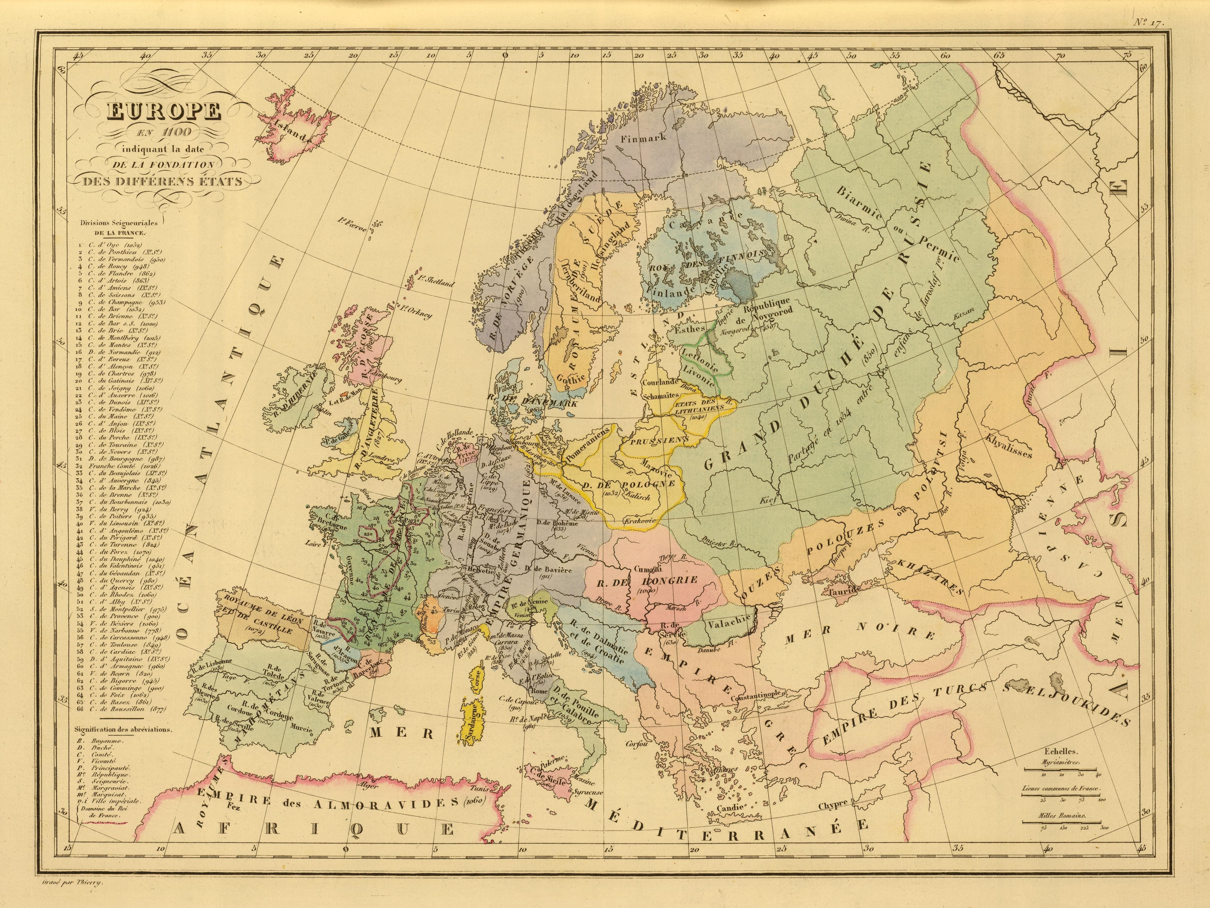
1100 Conrad Malte-Brun
(editor) - Pierre Lapie
(mapmaker): "Europe en
1100," Paris, from the
1812 Malte-Brun "Atlas
Complet Du Precis De La
Geographie Universelle."
From www.davidrumsey.com
(editor) - Pierre Lapie
(mapmaker): "Europe en
1100," Paris, from the
1812 Malte-Brun "Atlas
Complet Du Precis De La
Geographie Universelle."
From www.davidrumsey.com

1100 Conrad Malte-Brun
(editor) - Aime Andre
(publisher): "Europe en
1100," Paris, from the
1837 Malte-Brun "Atlas
Complet Du Precis De La
Geographie Universelle."
From www.davidrumsey.com
(editor) - Aime Andre
(publisher): "Europe en
1100," Paris, from the
1837 Malte-Brun "Atlas
Complet Du Precis De La
Geographie Universelle."
From www.davidrumsey.com

1608 Frans Hogenberg
(engraver) - Jan Vrients
(publisher) - Abraham
Ortelius: "EVROPAE,"
Antwerp, from "Theatro
Del Mondo...," the first
Ortelius edition in Italian.
From www.davidrumsey.com
(engraver) - Jan Vrients
(publisher) - Abraham
Ortelius: "EVROPAE,"
Antwerp, from "Theatro
Del Mondo...," the first
Ortelius edition in Italian.
From www.davidrumsey.com

1570 Abraham Ortelius (mapmaker/editor) - Frans
Hogenberg (engraver) - Gielis Coppens van Diest
(publisher): "EVROPAE," Antwerp, in uncolored and
colored versions from the first edition of the first atlas:
"Theatrum Orbis Terrarum." "Africas Pars" in roman
type denotes these maps as from the first edition. See
the 1595, 1603 and 1608 second edition versions.


1804 Dávid Pethes:
"EURÓPA," Debrecen,
Hungary. From University
of Debrecen, Hungary, via
www.theeuropeanlibrary.org
"EURÓPA," Debrecen,
Hungary. From University
of Debrecen, Hungary, via
www.theeuropeanlibrary.org


1225-50 Space Cadet:
"Teutonic Order State."
From English language
wikimedia
"Teutonic Order State."
From English language
wikimedia

1360 Ramsay Muir:
"Europe c1360,"from
"Philips' New Historical
Atlas for Students" of
1911.From http://source
books. fordham.edu/
"Europe c1360,"from
"Philips' New Historical
Atlas for Students" of
1911.From http://source
books. fordham.edu/
1743 Johann Matthias
Haase: "Europa Secun-
dum legitimas Projec-
tionis Stereographicae,"
Nürnberg, based on his
stereographic horizontal
projection. From
www.raremaps.com
Haase: "Europa Secun-
dum legitimas Projec-
tionis Stereographicae,"
Nürnberg, based on his
stereographic horizontal
projection. From
www.raremaps.com


c. 1683 Nicholas Sanson
(engineer/cartographer/
publisher): "Evrope,"
Amsterdam, 9 x 7
inches. From
www.raremaps.com
(engineer/cartographer/
publisher): "Evrope,"
Amsterdam, 9 x 7
inches. From
www.raremaps.com

1717 Herman Moll: "The
seat of War in the North
or a Map of the Baltick,"
London. From the Norman B.
Leventhal Map Center at the
Boston Public Library:
www.leventhalmap.org
seat of War in the North
or a Map of the Baltick,"
London. From the Norman B.
Leventhal Map Center at the
Boston Public Library:
www.leventhalmap.org

c. 1630 Jodocus Hondius:
"Europa," London, 7.5 x 6
inches, from a plate that
looks identical to the one
used by Samuale Purchas
for the 1625-26 edition of
his "Purchas His
Pilgrimes." From
www.raremaps.com
"Europa," London, 7.5 x 6
inches, from a plate that
looks identical to the one
used by Samuale Purchas
for the 1625-26 edition of
his "Purchas His
Pilgrimes." From
www.raremaps.com

1730 Herman Moll: " To
Her most Sacred Majesty
Carolina Queen of Great
Britain, France & Ireland,
this map of Europe...is
most Humbly Dedicated,"
London, 57 x 96 cm. From
Norman B. Leventhal Map
Center, Boston Public Library:
www.leventhalmap.org
Her most Sacred Majesty
Carolina Queen of Great
Britain, France & Ireland,
this map of Europe...is
most Humbly Dedicated,"
London, 57 x 96 cm. From
Norman B. Leventhal Map
Center, Boston Public Library:
www.leventhalmap.org
1742 Guillaume Delisle -
Covens et Mortier: "Carte
d'Europe..," Amsterdam,
49 x 59 cm, from C&M's
"Atlas Nouveau..." From
www.davidrumsey.com
Covens et Mortier: "Carte
d'Europe..," Amsterdam,
49 x 59 cm, from C&M's
"Atlas Nouveau..." From
www.davidrumsey.com
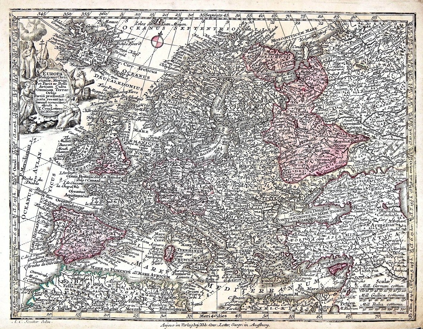
1744 Matthäus Seutter:
"Europa Religionis
Christianae Morum Et
Pacis Ac Belliartium
Culto Omnium…"
Augsburg, 20 x 26 cm,
from "Atlas Minor." From
the National Library of
Finland: www.doria.fi
"Europa Religionis
Christianae Morum Et
Pacis Ac Belliartium
Culto Omnium…"
Augsburg, 20 x 26 cm,
from "Atlas Minor." From
the National Library of
Finland: www.doria.fi


1772 (dated 1770) Louis
Charles Desnos: "L'Europe
Divisee Selon L'Etendue
De Ses Principales
Parties..."
Charles Desnos: "L'Europe
Divisee Selon L'Etendue
De Ses Principales
Parties..."

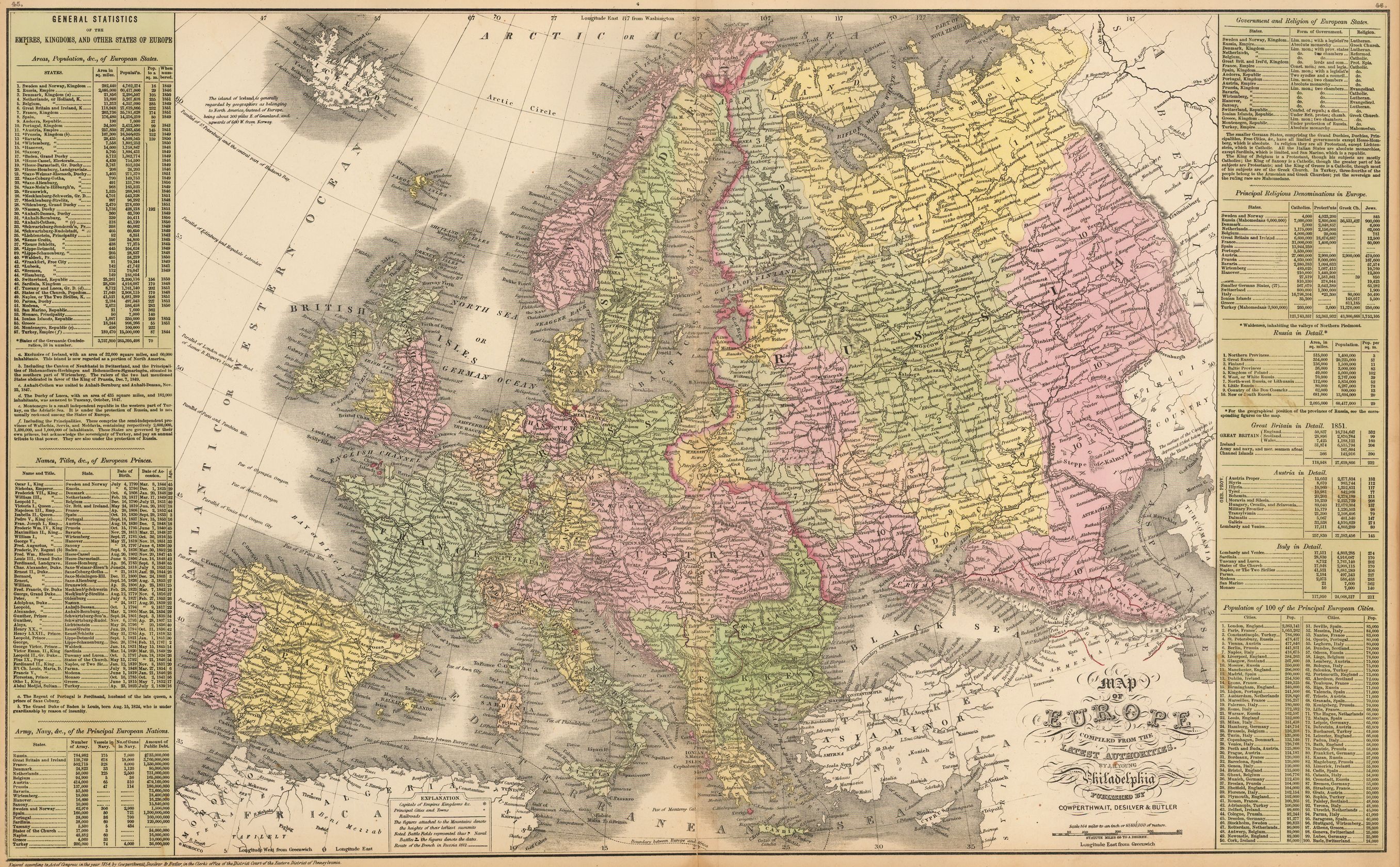
1854 & 1857 James Young (engraver) - Cowperthwaite, Desilver & Butler (1854 publishers) -
Charles Desilver (1857 publisher): "Map of Europe Compiled From The Latest Authorities,"
Philadelphia, 26 x 16" from 1854 and 1856 editions of Mitchell's "A New Universal Atlas."
Note the boundaries and statistics for "7. North-west Russia, or Lithuania," which stretches
south to today's Balta, Odessa Oblast, in southwest Ukraine.
| 1854 www.raremaps.com |
| 1857 www.raremaps.com |

1787 Elia Endasian
(mapmaker): "Europia, est
nor ashkharhagrakan
znnut'eants..." (Europe,
according to recent geo-
graphical observations),
Venice, first map of
Europe in Armenian. From
www.raremaps.com
(mapmaker): "Europia, est
nor ashkharhagrakan
znnut'eants..." (Europe,
according to recent geo-
graphical observations),
Venice, first map of
Europe in Armenian. From
www.raremaps.com

1795 Thomas Kitchin - Jean
Baptiste Bourguignon d'Anville -
Laurie & Whittle: "Europe divided
into its Empires, Kingdoms,
States..," London, 104 x 123 cm.
Shows 1st & 2nd Partition
boundaries, with a label for "Russian
Lithuania" for First Partition
territory losses of the Grand Duchy.
From www.davidrumsey.com
Baptiste Bourguignon d'Anville -
Laurie & Whittle: "Europe divided
into its Empires, Kingdoms,
States..," London, 104 x 123 cm.
Shows 1st & 2nd Partition
boundaries, with a label for "Russian
Lithuania" for First Partition
territory losses of the Grand Duchy.
From www.davidrumsey.com

c. 1670 Richard Blome: "A
New Mapp of Europe
Designed by Mounsieur
Sanson...1669," London,
22 x 16 inches, from his
"Geographical Descrip-
tion of the Four Parts of
the World." From www.
raremaps.com
New Mapp of Europe
Designed by Mounsieur
Sanson...1669," London,
22 x 16 inches, from his
"Geographical Descrip-
tion of the Four Parts of
the World." From www.
raremaps.com

1769 Guillaume Delisle:
"Carte d'Europe...1724...
Philippe Buache 1760...
1769," Paris, 50 x 62
cm. From the US Library of
Congress: www.loc.gov
"Carte d'Europe...1724...
Philippe Buache 1760...
1769," Paris, 50 x 62
cm. From the US Library of
Congress: www.loc.gov
1598 Girolamo Ruscelli:
"EVROPÆ TABVLA VIII,"
Venice, 10 x 9 inches. His
Ptolemy-based Atlas was
an expanded edition of
Gastaldi's Atlas of 1548.
From www.raremaps.com
"EVROPÆ TABVLA VIII,"
Venice, 10 x 9 inches. His
Ptolemy-based Atlas was
an expanded edition of
Gastaldi's Atlas of 1548.
From www.raremaps.com

Ramsay Muir: "Europe in
1519," from the 1911
"Philips' new historical
atlas for students," but
commonly referred to as
"Muir's Historical Atlas."
From http://sourcebooks.
fordham.edu/
1519," from the 1911
"Philips' new historical
atlas for students," but
commonly referred to as
"Muir's Historical Atlas."
From http://sourcebooks.
fordham.edu/

Ramsay Muir: "Europe at
the Peace of Westphalia,
1648," from the 1911
"Philips' new historical
atlas for students," often
referred to as "Muir's
Historical Atlas." From
http://sourcebooks.
fordham.edu/
the Peace of Westphalia,
1648," from the 1911
"Philips' new historical
atlas for students," often
referred to as "Muir's
Historical Atlas." From
http://sourcebooks.
fordham.edu/

1744 (dated) Nicolas Bion:
"L'Europe," Paris, 7 1/2 x 6 1/2
inches, from "L' usage des globes
celeste et terrestre, et des spheres
suivant les differens systemes du
monde," published by , Guerin &
Nyon. From oldmapsoldbooks on eBay
"L'Europe," Paris, 7 1/2 x 6 1/2
inches, from "L' usage des globes
celeste et terrestre, et des spheres
suivant les differens systemes du
monde," published by , Guerin &
Nyon. From oldmapsoldbooks on eBay
1776 Jean Janvier (geo-
grapher/cartographer):
"L'Europe divisee en ses
Principaux Etats," Paris,
drawn in 1762 for the
1776 "Atlas Moderne."
From www.geographicus.
com via wikimedia
grapher/cartographer):
"L'Europe divisee en ses
Principaux Etats," Paris,
drawn in 1762 for the
1776 "Atlas Moderne."
From www.geographicus.
com via wikimedia

1766 Guillaume Danet
(1731 cartographer) -
Louis Charles Desnos
(revising cartographer
/publisher): "L'Europe
Divisee Dans Ses
Principaux Etats," Paris,
27 x 20 inches. From
www.raremaps.com
(1731 cartographer) -
Louis Charles Desnos
(revising cartographer
/publisher): "L'Europe
Divisee Dans Ses
Principaux Etats," Paris,
27 x 20 inches. From
www.raremaps.com
| www.bergbook.com |
| www.raremaps.com |
| 1540 jpmaps.co.uk |
| 1542 www.raremaps.com |
| 1545 lusarag on eBay |
| 1552 www.bergbook.com |
| 1552 www.raremaps.com |
| 1598 www.swaen.com |
| 1561 bertius on eBay |
| 1574 www.alexandremaps.com |
| 1574 bertius on eBay |
| 1574 www.alexandremaps.com |
| www.davidrumsey.com |
| www.orteliusmaps.com via wikimedia |
| www.raremaps.com |
| 1591 LIETUVOS DAILĖS FONDAS: ldfondas.lt/ |
| http://kazantip.rork.ru/ biblio/ptolemeus.htm |
| www.raremaps.com |
| www.raremaps.com |
| www.raremaps.com |
| www.jpmaps.co.uk |
| www.raremaps.com |

| www.raremaps.com |
| www.raremaps.com |

| 1541 www.rare-atlases.com |
| 1535 |

1766 John Spilsbury
(geographer/jigsaw
puzzle-maker): "Europe Divided
into its Kingdoms,"
London. Perhaps the
first jigsaw puzzle. The
British Library, via
wikimedia
(geographer/jigsaw
puzzle-maker): "Europe Divided
into its Kingdoms,"
London. Perhaps the
first jigsaw puzzle. The
British Library, via
wikimedia

1812 Pierre Lapie (map-
maker) - Conrad Malte-
Brun (geographer/ pub-
lisher): "Europe," Paris,
from "Atlas complet du
précis de la géographie
universelle." Russian
guberniyas are
unlabeled. From
www.davidrumsey.com
maker) - Conrad Malte-
Brun (geographer/ pub-
lisher): "Europe," Paris,
from "Atlas complet du
précis de la géographie
universelle." Russian
guberniyas are
unlabeled. From
www.davidrumsey.com
"Europe in 1721," London,
from 1912's "The Cam-
bridge Modern History
Atlas." See 1648 version
for change in position of
label for "Lithuania. From
www.lib.utexas.edu
Perry-Castañeda Library
from 1912's "The Cam-
bridge Modern History
Atlas." See 1648 version
for change in position of
label for "Lithuania. From
www.lib.utexas.edu
Perry-Castañeda Library


1760 Richard William Seale (engraver/
mapmaker): "A new and compleat map of
the parts of Sweden, Russia, Germany,
Poland and Denmark; bordering on the
Baltick Sea exhibiting the present Seat of
war between those several powers,"
London, from The Universal Magazine of
Knowledge and Pleasure. From
lindisfarne2 on eBay
mapmaker): "A new and compleat map of
the parts of Sweden, Russia, Germany,
Poland and Denmark; bordering on the
Baltick Sea exhibiting the present Seat of
war between those several powers,"
London, from The Universal Magazine of
Knowledge and Pleasure. From
lindisfarne2 on eBay
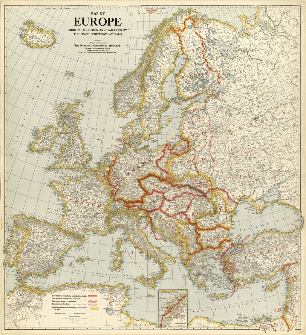
1920 National Geograph-
ic Magazine (publisher):
"Map of Europe Showing
Countries as Established
by the Peace Conference
[of 1919] in Paris," Wash-
ington, DC. Baltic States
and Polish boundaries are
undecided. From Library of
Congress via www.wdl.org
ic Magazine (publisher):
"Map of Europe Showing
Countries as Established
by the Peace Conference
[of 1919] in Paris," Wash-
ington, DC. Baltic States
and Polish boundaries are
undecided. From Library of
Congress via www.wdl.org
1811 William Darton
(publisher): ""A New
Map of Europe," Lon-
don, 28 x 23 cm.
Strangely inaccurate
boundaries for
Poland. From
www.davidrumsey..com
(publisher): ""A New
Map of Europe," Lon-
don, 28 x 23 cm.
Strangely inaccurate
boundaries for
Poland. From
www.davidrumsey..com
c. 1806-09 Eustache Hérisson (hydro-
graphical engineer/geographer) - C.B.
Glot (engraver): "Nouvelle Carte
Générale et Détaillée de l'Europe," Paris,
depicting "Gouv. de Vilna" and "Gouv. de
Slonim" guberniyas, which existed only
from 1795-96. The only map of Europe I
have found showing these entities. From
the National Library of France:
www.gallica.bnf.fr


c. 1576 Franz Hogenber:g
(engraver/mapmaker):
"EVROPAE," Frankfurt,
13.5 x 19.5 inches,
derived from Ortelius'
8-sheet cordiform world
map of 1564. From
www.raremaps.com
(engraver/mapmaker):
"EVROPAE," Frankfurt,
13.5 x 19.5 inches,
derived from Ortelius'
8-sheet cordiform world
map of 1564. From
www.raremaps.com

1721 John Senex: "A
New Map of Europe From
the latest Observations,"
London, 22.5 x 19
inches, from his large
format "World Atlas."
From www.raremaps.com
New Map of Europe From
the latest Observations,"
London, 22.5 x 19
inches, from his large
format "World Atlas."
From www.raremaps.com

1626 [dated] John Speed:
"Evrop, and the cheife
Cities contained therin..."
London -- the first edition
of his decorative map of
Europe, including
birds-eye city views and
figures. From
www.raremaps.com
"Evrop, and the cheife
Cities contained therin..."
London -- the first edition
of his decorative map of
Europe, including
birds-eye city views and
figures. From
www.raremaps.com

1595 Abraham Ortelius:
"EVROPAE," Antwerp,
13.5 x 18 inches, second
edition, inaccurately
colored. Inputs: Mercator,
Magnus, Jenkinson. From
www.raremaps.com
"EVROPAE," Antwerp,
13.5 x 18 inches, second
edition, inaccurately
colored. Inputs: Mercator,
Magnus, Jenkinson. From
www.raremaps.com

1817 John Thomson
(publisher) - J. & G. Menzies
(engravers): "Europe,"
Edinburgh, 21 x 18 inches.
Shows former eastern
boundary of the
Commonwealth, but does
not label Lithuania. From
www.raremaps.com
(publisher) - J. & G. Menzies
(engravers): "Europe,"
Edinburgh, 21 x 18 inches.
Shows former eastern
boundary of the
Commonwealth, but does
not label Lithuania. From
www.raremaps.com

1651 Nicolas Picart (cartographer):
"Nouuele Description de L'EUROPE," Paris,
15 x 20 cm, from his "Tresor des carte
Geographiques." The map, an updated
version of Jansson's 1628 map, depicts the
boundaries of "Litvanie, " as a narrow slice
of "Rvssie." From www.maphouse.co.uk
"Nouuele Description de L'EUROPE," Paris,
15 x 20 cm, from his "Tresor des carte
Geographiques." The map, an updated
version of Jansson's 1628 map, depicts the
boundaries of "Litvanie, " as a narrow slice
of "Rvssie." From www.maphouse.co.uk
1598 Matthias Quad
(geographer/ engraver) -
Johann Bussemachaer
(publisher): "Evropa,"
Cologne, 12 x 8.5 inches,
from Quad's "Europae
totius orbis terrarum,"
smaller and cheaper than
atlases by Ortelius, Mer-
cator, and the De Jodes.
From www.raremaps.com
(geographer/ engraver) -
Johann Bussemachaer
(publisher): "Evropa,"
Cologne, 12 x 8.5 inches,
from Quad's "Europae
totius orbis terrarum,"
smaller and cheaper than
atlases by Ortelius, Mer-
cator, and the De Jodes.
From www.raremaps.com

1804 [dated] John Cary
(engraver/map seller): "A
New Map of Europe, from
the Latest Authorities."
London, 20 x 18 inches,
with novel boundaries
and coloring for former
Poland-Lithuania. From
www.raremaps.com
(engraver/map seller): "A
New Map of Europe, from
the Latest Authorities."
London, 20 x 18 inches,
with novel boundaries
and coloring for former
Poland-Lithuania. From
www.raremaps.com

1607 Gerard Mercator
(original cartographer) -
Jodocus Hondius (reducing
cartographer) - Johannes I
Janssonius (publisher):
"EUROPA," Amsterdam,
17 x 23 cm, from the first
edition of "Atlas Minor
Gerardi Mercatoris." From
www.davidrumsey.com
(original cartographer) -
Jodocus Hondius (reducing
cartographer) - Johannes I
Janssonius (publisher):
"EUROPA," Amsterdam,
17 x 23 cm, from the first
edition of "Atlas Minor
Gerardi Mercatoris." From
www.davidrumsey.com

1667 Abraham Oretlius
(original cartographer) -
Pietro Marchetti
(plagiarizing publisher):
[Europa], Venice, 4 x 3
inches /10.2 x 7.6 cm.
From
www.oldworldauctions.com
(original cartographer) -
Pietro Marchetti
(plagiarizing publisher):
[Europa], Venice, 4 x 3
inches /10.2 x 7.6 cm.
From
www.oldworldauctions.com

1689 Gerrit Lucasz van
Schagen (engraver/carto-
grapher): "EUROPA delin-
eata et recens edita." Note
"Lithvania" outlined
seperately from "Polonia."
From wikimedia
Schagen (engraver/carto-
grapher): "EUROPA delin-
eata et recens edita." Note
"Lithvania" outlined
seperately from "Polonia."
From wikimedia

900 Antoine Philippe
Houze (mapmaker): "La
Russie, Suede, Norwege,
Danemarck a la fin du
IXe. siecle," Paris, from
"Atlas universel histor-
ique et geographique..."
From www.davidrumsey.com
Houze (mapmaker): "La
Russie, Suede, Norwege,
Danemarck a la fin du
IXe. siecle," Paris, from
"Atlas universel histor-
ique et geographique..."
From www.davidrumsey.com

1400 Antoine Philippe
Houze (mapmaker): "La
Russie, Suede, Norwege,
Danemarck a la fin du
XIVe. siecle," Paris, from
"Atlas universel histor-
ique et geographique..."
From www.davidrumsey.com
Houze (mapmaker): "La
Russie, Suede, Norwege,
Danemarck a la fin du
XIVe. siecle," Paris, from
"Atlas universel histor-
ique et geographique..."
From www.davidrumsey.com

768 – 814 Reginald Lane:
"Europe in the time of
Charles The Great"
(Charlemagne), London,
Oxford, New York, from
"Historical Atlas of
Modern Europe..." From
www.flickr.com/photos/uconn
librariesmagic/
"Europe in the time of
Charles The Great"
(Charlemagne), London,
Oxford, New York, from
"Historical Atlas of
Modern Europe..." From
www.flickr.com/photos/uconn
librariesmagic/

c. 1710 Albert Schut (engraver) -
Cornelis Danckerts the Younger
(publisher): "D'Reyse des Apostels
Pauli na Roomen etc." (St. Paul's
travel to Rome [from Jerusalem]),
20.5 x 14.5 inches, in the first
state, published in a Dutch bible.
From www.oldworldauctions.com
Cornelis Danckerts the Younger
(publisher): "D'Reyse des Apostels
Pauli na Roomen etc." (St. Paul's
travel to Rome [from Jerusalem]),
20.5 x 14.5 inches, in the first
state, published in a Dutch bible.
From www.oldworldauctions.com
1919 C.S. Hammond &
Co. (publisher): "Europe
showing the proposed
new states," recommend-
ed at the Versailles Peace
Conference. From Boston
Public Library via Digital
Public Library of America:
https://dp.la/
Co. (publisher): "Europe
showing the proposed
new states," recommend-
ed at the Versailles Peace
Conference. From Boston
Public Library via Digital
Public Library of America:
https://dp.la/


1094 – 1291 Johann
Georg Heck (cartographer)
- Engelmann & Compagnie
(publisher): "Carte de
l'Europe et du theatre de la
guerre au temps des
croisades," Paris, from
"Atlas geographique,"
1834.www.davidrumsey.com
Georg Heck (cartographer)
- Engelmann & Compagnie
(publisher): "Carte de
l'Europe et du theatre de la
guerre au temps des
croisades," Paris, from
"Atlas geographique,"
1834.www.davidrumsey.com

1919 [dated] A.J. Nystrom
and Co. (publisher): "[The
New] Europe," Chicago,
with "New political boun-
daries shown by red lines."
No Latvia on the map!
From Norman B. Leventhal
Map Center Collection at Boston
Public Library via Digital
Commonwealth:
www.digitalcommonwealth.org
and Co. (publisher): "[The
New] Europe," Chicago,
with "New political boun-
daries shown by red lines."
No Latvia on the map!
From Norman B. Leventhal
Map Center Collection at Boston
Public Library via Digital
Commonwealth:
www.digitalcommonwealth.org

c. 1920 Société De
Cartes Géograph-
iques Berne (map-
maker) - Librairie
Payot (publisher):
[Detail] “Carte Gén-
érale de L'Europe,"
Lausanne. The full
map is 132 MB. From
www.mapywig.org
Cartes Géograph-
iques Berne (map-
maker) - Librairie
Payot (publisher):
[Detail] “Carte Gén-
érale de L'Europe,"
Lausanne. The full
map is 132 MB. From
www.mapywig.org

1547 [dated 1841]
Achille Meissas (geo-
grapher) - Auguste
Michelot (bookseller) -
Philippe Dumortier
(engraver): "Europe vers
1547, la mort de Francois
1er." From
www.davidrumsey.com
Achille Meissas (geo-
grapher) - Auguste
Michelot (bookseller) -
Philippe Dumortier
(engraver): "Europe vers
1547, la mort de Francois
1er." From
www.davidrumsey.com

J.B. Bury (editor) - Long-
mans Green (publisher):
"2nd Crusade: 1147-50;
3rd Crusade: 1189-92,"
from "Atlas to Freeman's
Historical Geography."
From wikimedia
mans Green (publisher):
"2nd Crusade: 1147-50;
3rd Crusade: 1189-92,"
from "Atlas to Freeman's
Historical Geography."
From wikimedia

1918 Alexander
Gross (mapmaker) -
Geographia Ltd.
(publisher)’: "The
Daily Telegraph
War Map (No 29),"
London. From the
American Geographical
Society Library at Univ.
Wisconsin, Milwaukee,
Libraries: https:
//collections.lib.uwm.edu/
Gross (mapmaker) -
Geographia Ltd.
(publisher)’: "The
Daily Telegraph
War Map (No 29),"
London. From the
American Geographical
Society Library at Univ.
Wisconsin, Milwaukee,
Libraries: https:
//collections.lib.uwm.edu/
c. 1919 C.S. Hammond &
Co. (publisher): "Europe
showing peace confer-
ence boundaries," New
York, 48 x 58 cm, on
linen, "Made for Nelson's
perpetual loose-leaf
encyclopedia." From the
Americam Geographical
Society Library at Univ. of
Wisconsin, Milwaukee::
www.collections.lib.uwm.edu/
Co. (publisher): "Europe
showing peace confer-
ence boundaries," New
York, 48 x 58 cm, on
linen, "Made for Nelson's
perpetual loose-leaf
encyclopedia." From the
Americam Geographical
Society Library at Univ. of
Wisconsin, Milwaukee::
www.collections.lib.uwm.edu/


c. 1919 Giovanni Bertoldo
(mapmaker) - Istituto
geografico De Agostini
(publisher): "Carta-base
della futura Europa
politica," Novara, Italy,
56 x 68 cm. Latvia and
Lithuania conjoined. From
the Americam Geographical
Society Library, Univ. of
Wisconsin, Milwaukee,
Libraries: https://collections.
lib.uwm.edu/
(mapmaker) - Istituto
geografico De Agostini
(publisher): "Carta-base
della futura Europa
politica," Novara, Italy,
56 x 68 cm. Latvia and
Lithuania conjoined. From
the Americam Geographical
Society Library, Univ. of
Wisconsin, Milwaukee,
Libraries: https://collections.
lib.uwm.edu/
1918 The Graphic
Magazine: "RUSSIA
DISMEMBERING
HERSELF"
Magazine: "RUSSIA
DISMEMBERING
HERSELF"

1918 [dated] Kenyon Co.
(publisher): "War Map of
Europe..," Des Moines.
See boundaries for
Lithuania. From Amer.
Geographical Society
Collection at : www.
collections.lib.uwm.edu/
(publisher): "War Map of
Europe..," Des Moines.
See boundaries for
Lithuania. From Amer.
Geographical Society
Collection at : www.
collections.lib.uwm.edu/

1919 [dated]Kenyon Co.
(publisher): "Reconstruct-
ed Map of Europe," Des
Moines, now showing all
the Baltic states as still
part of Russia. From Amer.
Geographical Society
Collection at : www.
collections.lib.uwm.edu/
(publisher): "Reconstruct-
ed Map of Europe," Des
Moines, now showing all
the Baltic states as still
part of Russia. From Amer.
Geographical Society
Collection at : www.
collections.lib.uwm.edu/

1917 London Geograph-
ical Institute (mapmaker)
- George Philip & Son
(publisher): "The Allies'
Peace Terms: Suggestions
for the New Map of
Europe on a National
Basis," London, 35 x 40
cm. From the American Geo-
graphical Society collection at
the Univ. of Wisconsin:
https://collections.lib.uwm.edu/
ical Institute (mapmaker)
- George Philip & Son
(publisher): "The Allies'
Peace Terms: Suggestions
for the New Map of
Europe on a National
Basis," London, 35 x 40
cm. From the American Geo-
graphical Society collection at
the Univ. of Wisconsin:
https://collections.lib.uwm.edu/
c. 1918 Geographischer
Karten Verlag (mapmaker/
publisher): "Das Kommen-
de Europa" (The Coming
Europe), Bern, 46 x 60
cm. From the American Geo-
graphical Society collection at
the Univ. of Wisconsin:
https://collections.lib.uwm.edu/
Karten Verlag (mapmaker/
publisher): "Das Kommen-
de Europa" (The Coming
Europe), Bern, 46 x 60
cm. From the American Geo-
graphical Society collection at
the Univ. of Wisconsin:
https://collections.lib.uwm.edu/

c. 1687 Philip Lea
(cartographer/publisher):
"A New Mapp of Europe
Divided into its Principall
Kingdoms, and Prov- inces,"
London, 48 x 56 cm. From John
Carter Brown Library:
https://jcb.lunaimaging.com/
(cartographer/publisher):
"A New Mapp of Europe
Divided into its Principall
Kingdoms, and Prov- inces,"
London, 48 x 56 cm. From John
Carter Brown Library:
https://jcb.lunaimaging.com/
1920: "EUROPE," from
"Leslie's New World Atlas,"
1920, NY., showing their
guesstimate of Post WWI
boundaries. From
www.etc.usf.edu.maps
"Leslie's New World Atlas,"
1920, NY., showing their
guesstimate of Post WWI
boundaries. From
www.etc.usf.edu.maps

1919 The London Geo-
graphical Institute (map-
maker) - George Philip &
Son (publisher): "Europe,"
London, 52 x 61 cm, depict-
ing areas administered by
the League of Nations,
including the Klaipėda
region. From the American
Geographical Society at the,
Univ. of Wisconsin- Milwaukee:
https://uwm.edu/libraries
graphical Institute (map-
maker) - George Philip &
Son (publisher): "Europe,"
London, 52 x 61 cm, depict-
ing areas administered by
the League of Nations,
including the Klaipėda
region. From the American
Geographical Society at the,
Univ. of Wisconsin- Milwaukee:
https://uwm.edu/libraries
1919 "The Rand McNally
Map of New Europe," 48
x 66 cm, along with a
summary of the
Versailles Peace Treaty.
From the Americam Geographical Society
Library at Univ. ofWisconsin, Milwaukee::
www.collections.lib.uwm.edu/
Map of New Europe," 48
x 66 cm, along with a
summary of the
Versailles Peace Treaty.
From the Americam Geographical Society
Library at Univ. ofWisconsin, Milwaukee::
www.collections.lib.uwm.edu/
1735 Petrus Schenk II:
"Europæ in Tabula
Geographica Deliniato,"
Leipzig and Amsterdam,
from a republished
Visscher's "Atlas
Contractus..." From Univ.
of Amsterdam: uvaerfgoed.nl
"Europæ in Tabula
Geographica Deliniato,"
Leipzig and Amsterdam,
from a republished
Visscher's "Atlas
Contractus..." From Univ.
of Amsterdam: uvaerfgoed.nl


Detail (the original full map is 105 MB!)
from 1940 Der Deutsche Automobil-Club
(DDAC) (publisher): "Europa Karte,"
Munich, showing "Litauen" with a
regained Vilnius region, "Suwalki" within
separate boundaries, and part of
disappeared-from-the-map Poland. From
www.mapywig.org
from 1940 Der Deutsche Automobil-Club
(DDAC) (publisher): "Europa Karte,"
Munich, showing "Litauen" with a
regained Vilnius region, "Suwalki" within
separate boundaries, and part of
disappeared-from-the-map Poland. From
www.mapywig.org

1943 General Drafting Co.
(mapmaker) - Esso (publisher):
"Boundary changes in Central
Europe since [March] 1938,
"New Jersey, an inset map on
"War map, Europe and North
Africa," available, according
to a line on the map, "...free at
Esso dealer stations." From Univ.
of Wisconsin, Milwaukee Libraries:
https://collections.lib.uwm.edu/

1705 Nicholas Sanson - Anthoine de
Winter (engraver): "Europa,"
Amsterdam, 9.1 x 7.1 inches / 23.1
x 18 cm, from Halma's Dutch edition
of A. Pherotee de la Croix's "Nouvelle
Methode Pour... la Geographie
Universelle." Note Swedish Livonia
mistakenly in "Pologne." From
www.oldworldauctions.com
Winter (engraver): "Europa,"
Amsterdam, 9.1 x 7.1 inches / 23.1
x 18 cm, from Halma's Dutch edition
of A. Pherotee de la Croix's "Nouvelle
Methode Pour... la Geographie
Universelle." Note Swedish Livonia
mistakenly in "Pologne." From
www.oldworldauctions.com