Maps: 1561 - 1576
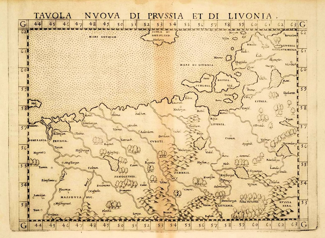
Girolamo Ruscelli: "TAVOLA NVOVA DI PRVSSIA ET DI LIVONIA," Venice, in versions from his own version of Ptolemy's "Geographia." The first two Ruscelli editions were published 1561 and 1562 by V.
Valgrisi. The third edition was published by G. Ziletti in 1564. Maps of the first five editions of Ruscelli were printed from the same copper plates of Valgrisi, which were based on the maps of Jacopo Gastaldi
which appeared in Mattioli's 1548 translation of Ptolemy's Geographia. Ruscelli enlarged the maps and included several additions. The sixth edition of Ruscelli's translation of Ptolemy's "Geografia" was edited
and extended by Giuseppe Rosaccio, and published by the heirs of M. Sessa in 1598 and 1599. The Valgrisi copper plates of the earlier Ruscelli editions were revised by Rosaccio and extended by five new plates.
Most of the Ptolemaic and modern maps were enhanced by ships, sea monsters, fishes, trees and additional place names. Map platemark 194 x 265 mm / 7.6 x 10.4 inches.
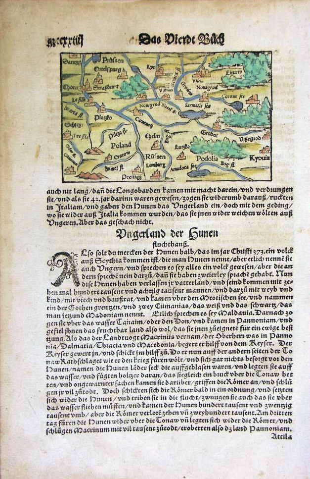
1569 Sebastian Munster: "Das vierdt buch." A miniature German- language "Cosmographia" (published
1544 - 1628) atlas page, 8 x 12 inches, with the map 6 3/4 x 10 1/2 inches, in two differently- colored
versions. Compare with the 1598 version.
1544 - 1628) atlas page, 8 x 12 inches, with the map 6 3/4 x 10 1/2 inches, in two differently- colored
versions. Compare with the 1598 version.
1561 Girolamo Ruscelli: "POLONIA ET HVNGARIA
NVOVA TAVOLA," Venice, 10 x 7 inches. The first
edition of Ruscelli's atlas was an expanded version of
Gastaldi's 1548 atlas. Ruscelli and Gastaldi's maps were
engraved on copper, a turning point in the history of
cartography. From that point on, the majority of
cartographic works used this medium. Harder than
wood, it gave the engraver the ability to render more
detail. The 1st edition was in Latin, all later editions
were translated into Italian. See the 1598-99 map
revised by Giuseppe Rosaccio.
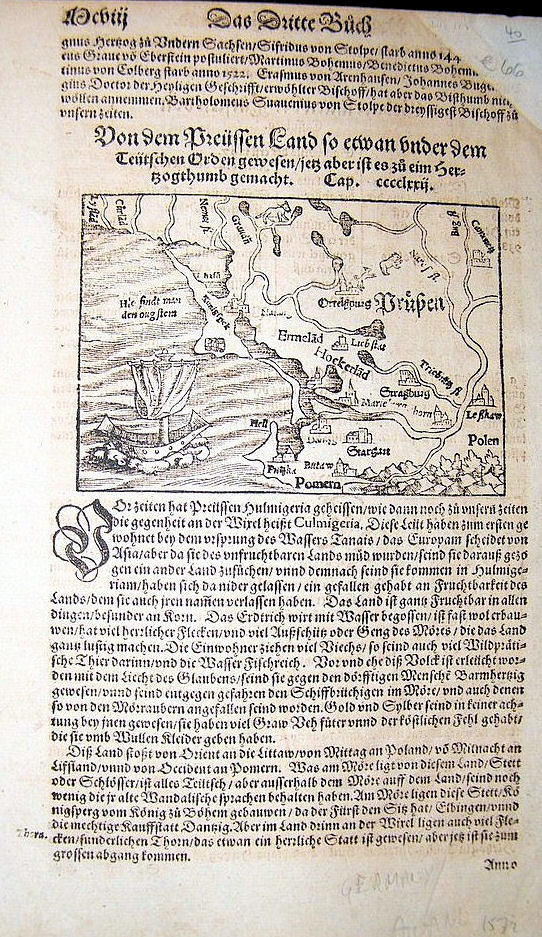
1570 Sebastian Munster: "...dem
Preuffen," from "Das Dritte
Buch," "Cosmographia." 8 x13
inches. Also a DETAIL image.
Preuffen," from "Das Dritte
Buch," "Cosmographia." 8 x13
inches. Also a DETAIL image.
Original engraver Vaclovas Grodeckis (Grodeccio); Frans Hogenberg: secondary engraver; various publishers; editor: Abraham Ortelius: "POLONIAE finitimarumque locorum descriptio. Auctore Wenceslao
Godreccio Polono." (Poland and nearby lands), from Ortelius' "Theatrum orbis terrarum," 49 x 36.4 cm / 19 x 14.5 inches, first issued 1570, and considered the very first atlas. The Theatrum went through
some 37 editions in Latin, German, French, Dutch, Spanish, English, and Italian. See more maps from this run on the next page.


1570 Sebastian Munster:
"Vondem königreich
Poland." A page from a
German-language
edition of the miniature
atlas "Cosmographia" From
Albion Prints, UK
"Vondem königreich
Poland." A page from a
German-language
edition of the miniature
atlas "Cosmographia" From
Albion Prints, UK


c. 1573-74 Jan (Joanne) Portant (Portantio): "LIVONIAE NOVA DESCRIPTIO, Joanne Portantio, auctore," Antwerp, printed as one of three maps on a sheet, in four versions. Portant was an
astronomer, mathematician, and geographer, and his original map, created c1571, was later used by Ortelius and by de Jode in 1584 and after.
astronomer, mathematician, and geographer, and his original map, created c1571, was later used by Ortelius and by de Jode in 1584 and after.

| 1570 www.jpmaps.com |
1571
1573
| 1574 AK-12. |
1575

| 1572 www.raremaps.com |

1569 Sebastian Munster :
"De regno & rota regione
Poloniae," from a
Latin-language version of
his miniature atlas
"Cosmographia." From
www.karty.by
"De regno & rota regione
Poloniae," from a
Latin-language version of
his miniature atlas
"Cosmographia." From
www.karty.by
1576

| 1572 www.swaen.com |
| 1561 1st Ed. National Library of Latvia: http://data.lnb.lv |

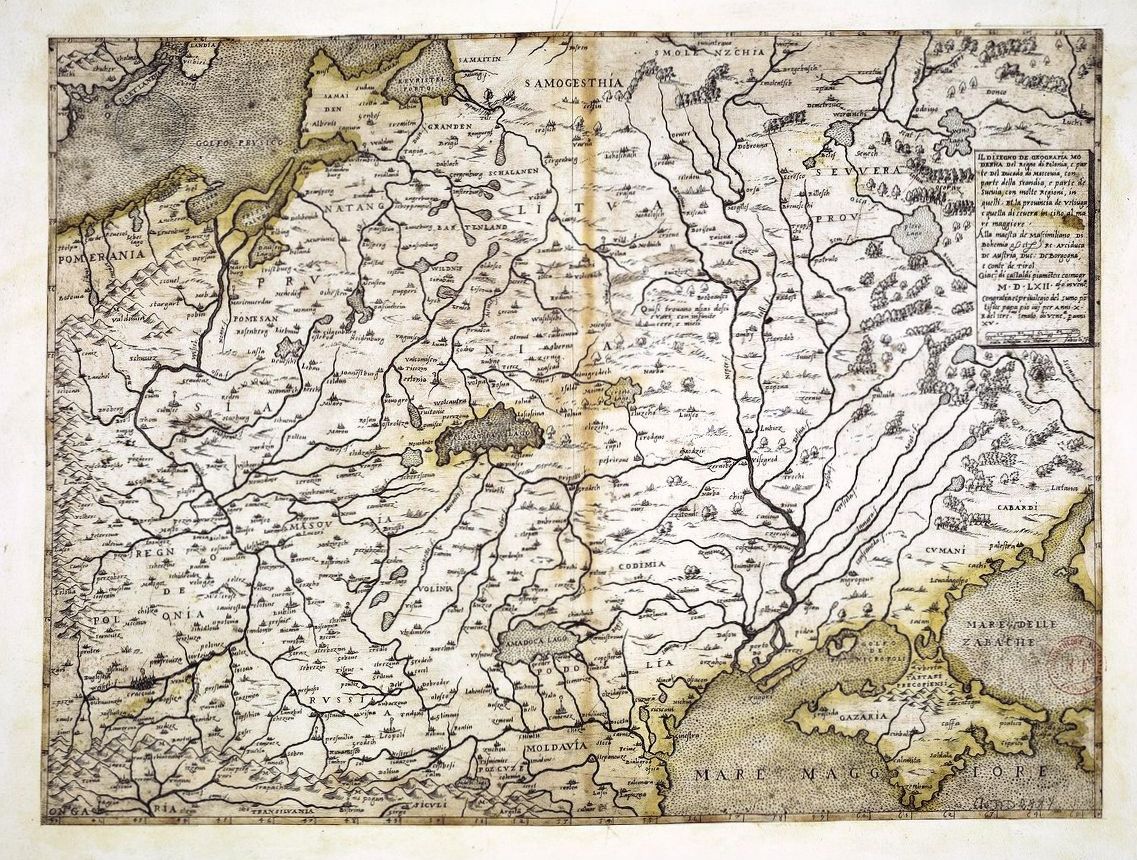
| 1562 Giacomo Gastaldi: "Il Disegno de Geografia Moderna del Regno di Polonia, e Parte del Ducado di Moscovia, con parte della Scandia , e parte de Suevia, con molte Regioni, in quelli. . . MDLXII . . ." Venice, 21 x 30.5 inches (if joined). The first edition of Gastaldi's 2-sheet map of the Kingdom of Poland, generally recognized as the earliest map to focus on Poland. Derived from Mercator's 1554 map of Europe, the map was also likely influenced by the maps of Bernard Wapowski (1526) and Grodeckis published in 1548, now lost, but copied by Ortelius in 1570. Paolo Forlani issued a subsequent edition of Gastadi's 2 sheet map in 1568. From www.raremaps.com |
| Univ. of Tartu, Estonia: http://dspace.utlib.ee/ |

| 1572 jremington1 on eBay |


| 1570 www.raremaps.com |

| 1575 www.oshermaps.org |

| 1572 www.sanderusmaps.com |

| 1570 www.davidrumsey.com |


1570 [dated] Andreas Pograbius (Andrzej
Pograbski) (physician/cartographer):
"Partis Sarmatiae Europae, quae Sigis-
mundo Augusto regi Poloniae potentissimo
subiacet nova descriptio," Venice, 47.3 x
69 cm. This plate was used by Ortelius
from 1595 onwards. From National Library of
Finland: http://www.doria.fi/
Pograbski) (physician/cartographer):
"Partis Sarmatiae Europae, quae Sigis-
mundo Augusto regi Poloniae potentissimo
subiacet nova descriptio," Venice, 47.3 x
69 cm. This plate was used by Ortelius
from 1595 onwards. From National Library of
Finland: http://www.doria.fi/

| National Library of Finland: http://www.doria.fi/ |
| Univ. of Tartu, Estonia: http://dspace.utlib.ee/ |
| Univ. of Tartu, Estonia: http://dspace.utlib.ee/ |
| 1562 2nd Ed. National Library of Latvia: http://data.lnb.lv |
| 1598 6th Ed. National Library of Latvia: http://data.lnb.lv |

| 1561 1st Ed. www.libreriaperini.com |

| 1564 3rd Ed. www.rare-atlases.com |

| 1598-99 6th Ed. www.rare-atlases.com |
| www.raremaps.com |

| 1562 Bottom Half National Library of France: www.gallica.bnf.fr |
| 1562 Bottom Half http://www.muzeum. krakow.pl/ |
| AK-23 |
| Albion Prints, UK |

| www.davidrumsey.com |
| 1568 Top Half National Library of Finland: http://www.doria.fi/ |

| 1570 Abraham Ortelius (mapmaker) - Frans Hogenberg (engraver) - Gielis Coppens van Diest (publisher): "Prvssiae Descriptio..," Antwerp, 30 x 43 cm. from the first edition of the first atlas of the world: "Theatrum Orbis Terrarum." From www.davidrumsey.com |
1570 [dated] Vaclovas
Grodeckis: "Poloniae,
Litvaniae, Rvssiae,
Prvssiae, Masoviae et
Scepvsij chorographia,"
Basel, 63 x 79 cm, in a
second edition. From
Harvard Map Collection:
http://vc.lib.harvard.edu
Grodeckis: "Poloniae,
Litvaniae, Rvssiae,
Prvssiae, Masoviae et
Scepvsij chorographia,"
Basel, 63 x 79 cm, in a
second edition. From
Harvard Map Collection:
http://vc.lib.harvard.edu

| 1564 3rd Ed. www.swaen.com |