Maps of Historical Lithuania 862 - 1795:
By date depicted, not date created
By date depicted, not date created
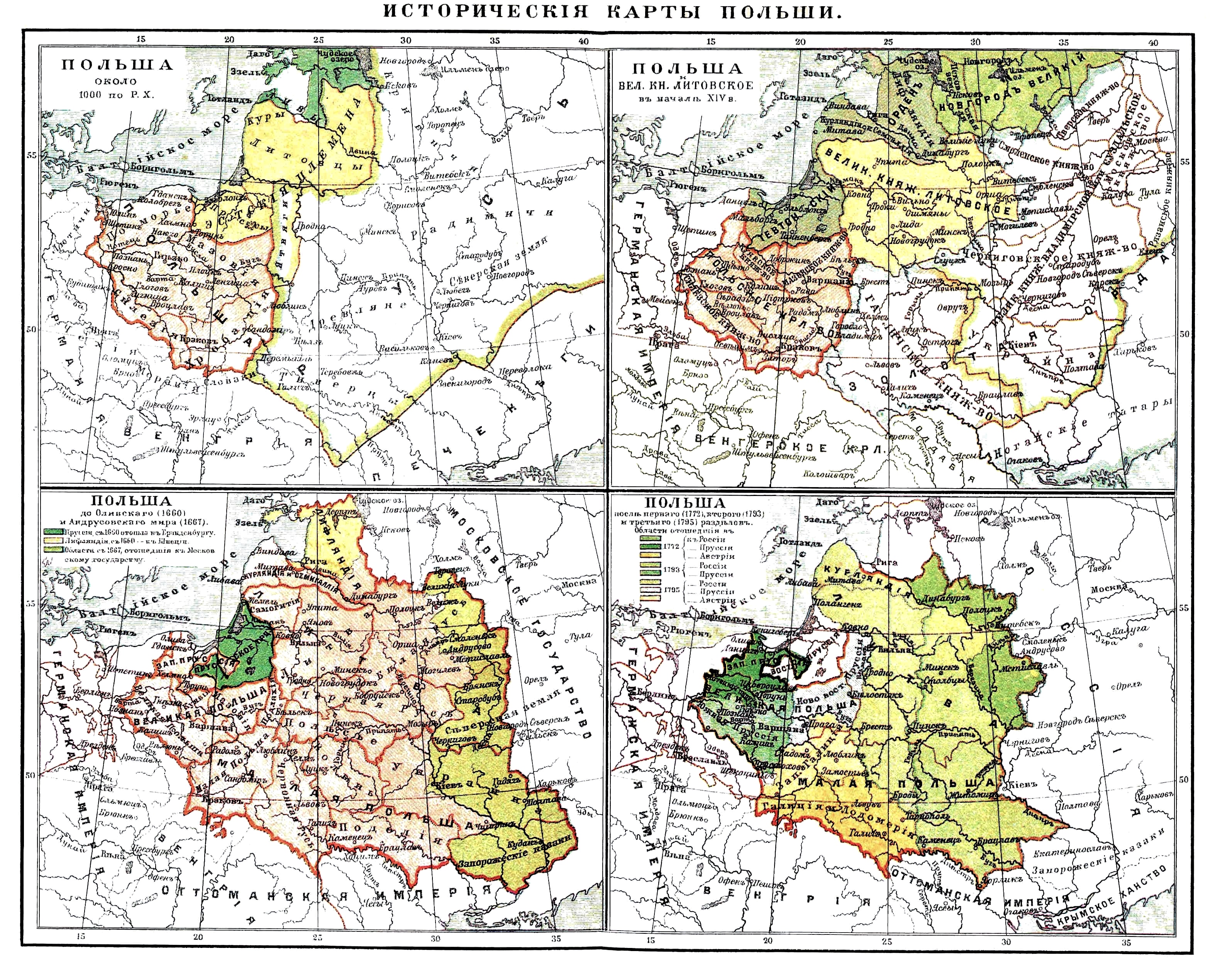
1000 - 1772 Karl Wolf:
"Karten zur Geschichte
Polens und Des Westlichen
Russlands, from the 4th
edition of "Meyers Konv.
Lexicon," published 1885-
92 in Vienna and Leipzig.
From westlichebibliothek.de
"Karten zur Geschichte
Polens und Des Westlichen
Russlands, from the 4th
edition of "Meyers Konv.
Lexicon," published 1885-
92 in Vienna and Leipzig.
From westlichebibliothek.de

13th Cent.: "LIETUVA:
MINDAUGO LAIKAIS."
(The Age of Mindaugas.)
MINDAUGO LAIKAIS."
(The Age of Mindaugas.)

14th-15th Cent.
"Litva." From
www.belarusguide. com
"Litva." From
www.belarusguide. com
13th-15th Cent.
"Lithuanian State."
"Lithuanian State."


15th Cent. "Lietuva."
1386 - 1572 Karl von
Spruner: "POLEN UND
LITTHAUEN unter den
Jagjellonen," from his
"Historisch Geographi-
scher Hand-atlas," 1855.
From www.davidrumsey.com
Spruner: "POLEN UND
LITTHAUEN unter den
Jagjellonen," from his
"Historisch Geographi-
scher Hand-atlas," 1855.
From www.davidrumsey.com

1569 "The Polish
Republic, Vassal states."
Republic, Vassal states."

1634-60 "Polish Republic."


1686 ("Republic of Both
Nations.") From Halibutt on
Wikimedia Commons
Nations.") From Halibutt on
Wikimedia Commons

1772 "POLAND after the
first partition."
first partition."

1793 "POLAND after the
second parition."
second parition."

"POLAND in the year
1795"
1795"

1772-95 Partitions.
13th cent. Karl Spruner:
1. "Die OST-SEE LAENDER
..." 2. "PREUSSEN und
LIVLAND bis 1525-62."
From www.davidrumsey.com
1. "Die OST-SEE LAENDER
..." 2. "PREUSSEN und
LIVLAND bis 1525-62."
From www.davidrumsey.com

1660-67 "POLEN"

1772-95 "POLAND: THE
PARTITIONS," 1912
Cambridge History Atlas.
PARTITIONS," 1912
Cambridge History Atlas.

1569 "Poland and Lithua-
nia: The Union of Lublin."
1912 Cambridge History
Atlas
nia: The Union of Lublin."
1912 Cambridge History
Atlas

1400 Gustav Droysen:
"POLEN unter Jagello:"
1886 "Allgemeiner
historischer Handatlas."
"POLEN unter Jagello:"
1886 "Allgemeiner
historischer Handatlas."


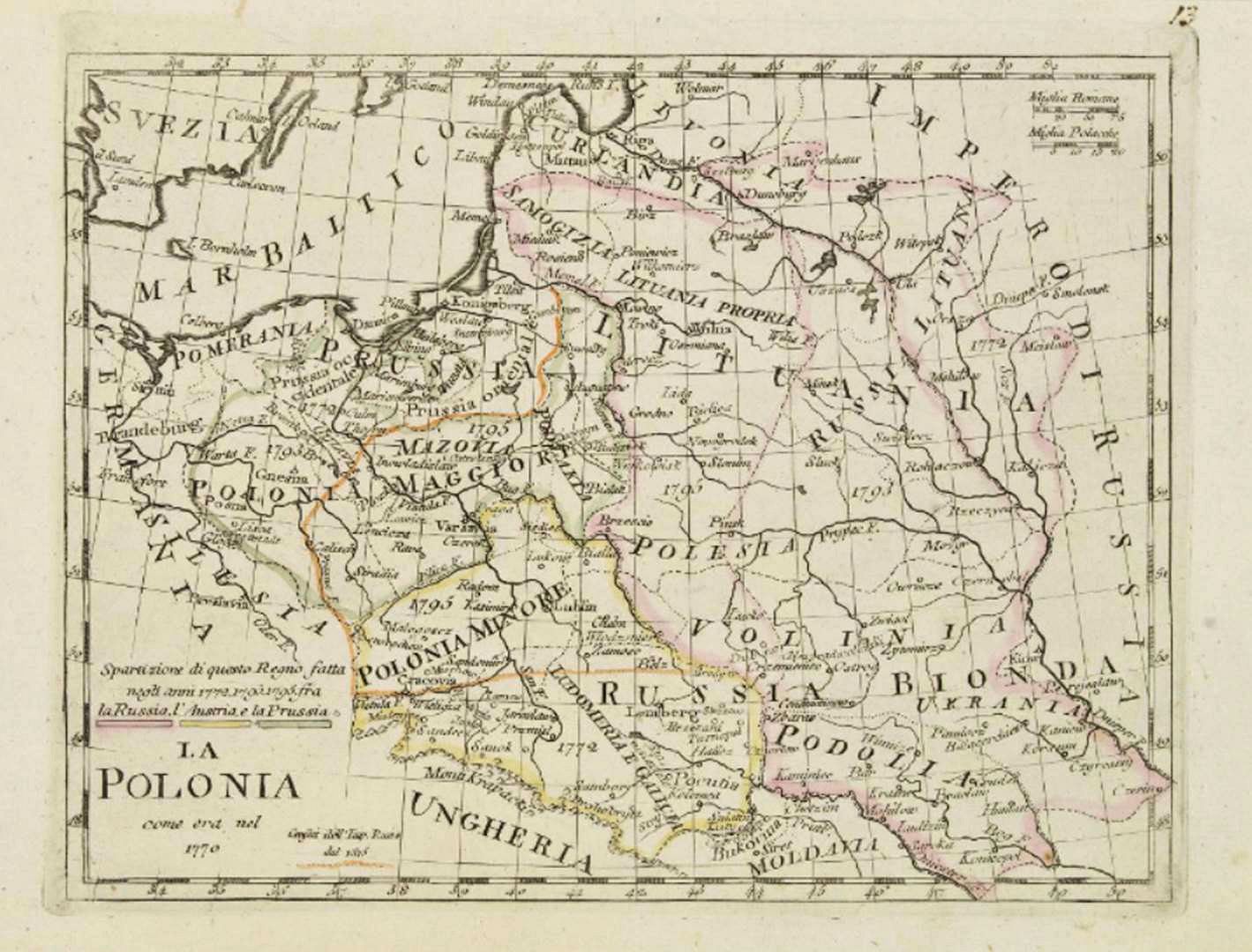
1772, 1793, 1795 "POLEN," the first, second, and third partitions from the 1880
Swedish "Historisk Atlas" by Hildebrand and Selander
Swedish "Historisk Atlas" by Hildebrand and Selander

1654 M.K.: Lithu-
ania's Administrative
Divisions. From wikimedia
ania's Administrative
Divisions. From wikimedia


1572 - 1795 "L'Ancienne
Pologne," from G. Heck's
1842 "Atlas Geograph
-ique." From mapsandmaps
Pologne," from G. Heck's
1842 "Atlas Geograph
-ique." From mapsandmaps

1795 Dr. Karl Spruner von Merz: "Polen bis zu seinem Untergange, 1795," Gotha, 33 x 40 cm, at 1:5 000 000, from three different
editions of Justus Perthes' "Historisch-geographischer Hand-Atlas zur Geschichte der Staaten Europa's vom Anfang des Mittelalters bis auf
die neueste Zeit."
editions of Justus Perthes' "Historisch-geographischer Hand-Atlas zur Geschichte der Staaten Europa's vom Anfang des Mittelalters bis auf
die neueste Zeit."
1000 - 1795 "Polish and
Lithuanian History" in a
Russian-language map
that looks identical to the
German one on the left.
Lithuanian History" in a
Russian-language map
that looks identical to the
German one on the left.
1568 - 1875: 9th ed.,
Encyc. Britannica:
"Kingdom of Poland, before
its union with Lithuania..,"
pub- lished 1875-89.
Encyc. Britannica:
"Kingdom of Poland, before
its union with Lithuania..,"
pub- lished 1875-89.


1772-95 "Die Teilungen
Polens im 18.
Jahrhundert"
Polens im 18.
Jahrhundert"


1772-95 "PARTITIONS OF
POLAND," New York, C.C.
Hammond, 1914. From
www.periodpapers.com
POLAND," New York, C.C.
Hammond, 1914. From
www.periodpapers.com


1386 - 1480 "POLEN,
LITTHAUEN..." from the
1880 Spruner-Menke
Handatlas." From
www.maproom.org
LITTHAUEN..." from the
1880 Spruner-Menke
Handatlas." From
www.maproom.org

1772 Leonard Chodzko: "Carte
Generale ROUTIERE HISTORIQUE
EY STATIS- TIQUE des Etats de
l'ancienne Republique de POLOGNE
...,"Paris, 1840, showing 1772
partitions.
Generale ROUTIERE HISTORIQUE
EY STATIS- TIQUE des Etats de
l'ancienne Republique de POLOGNE
...,"Paris, 1840, showing 1772
partitions.


1562 Ludwig August von Mellin (mapmaker) - W.C. Friebe, J.F. Hartknoch
(publishers): "LIVLAND nach Eintheilung Heinrich des Letten..." (Livonia until after the
division of Henry the Lett...), Riga, Leipzig, from the 1798 "Atlas von Liefland..."
(publishers): "LIVLAND nach Eintheilung Heinrich des Letten..." (Livonia until after the
division of Henry the Lett...), Riga, Leipzig, from the 1798 "Atlas von Liefland..."
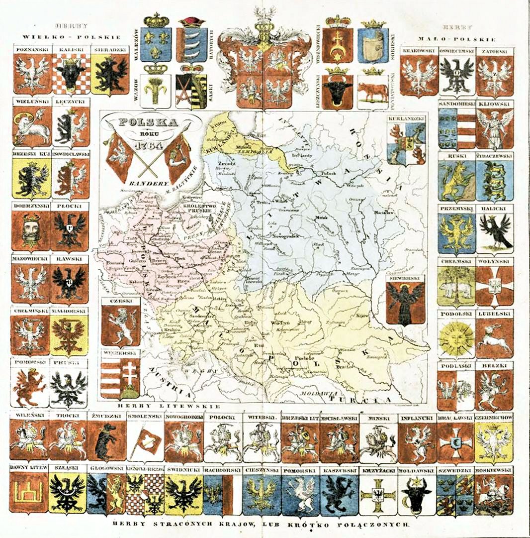
1764 Maria Regina Korzeniowska:
"POLSKA ROKU, 1764"coronation
of Stanisław August Poniatowski.
From her 1831 "Atlas historyczny
..." From rcin.org.pl
"POLSKA ROKU, 1764"coronation
of Stanisław August Poniatowski.
From her 1831 "Atlas historyczny
..." From rcin.org.pl
1619 "Rzeczpospolita
Polita Obojga Narodów"
(Commonwealth of the
Two Nations). From
wikimedia commons
Polita Obojga Narodów"
(Commonwealth of the
Two Nations). From
wikimedia commons


1200 - 1300 Matīss
Siliņš: "Baltic area at the
time of Henry of Livonia,"
Riga.The first historical
map of the Baltic in
Latvian, 1890. From:
National Library
of Latvia via europeana.eu
Siliņš: "Baltic area at the
time of Henry of Livonia,"
Riga.The first historical
map of the Baltic in
Latvian, 1890. From:
National Library
of Latvia via europeana.eu
1770 Joachim Lelwel:
(historian/mapmaker,
1786 - 1861): "POLOGNE
SOUS STANISLAV
AUGUSTE en 1770." From
Bibliotheque nationale de
France: www.gallica.bnf.fr
(historian/mapmaker,
1786 - 1861): "POLOGNE
SOUS STANISLAV
AUGUSTE en 1770." From
Bibliotheque nationale de
France: www.gallica.bnf.fr


1569-72 "POLEN UND
LITTHAUEN," from 1880
"Spruner-Menke Hand-
Atlas." From maproom.org
LITTHAUEN," from 1880
"Spruner-Menke Hand-
Atlas." From maproom.org

1480 - 1682 "ESTH-
LAND, LIVLAND,
KURLAND," from
1880's Spruner-
Menke "Hand-Atlas."
From maproom.org
LAND, LIVLAND,
KURLAND," from
1880's Spruner-
Menke "Hand-Atlas."
From maproom.org
1201 - 1237 Spruner-
Menke: "ESTHLAND,
LIVLAND, KURLAND...")
From www. maproom.org
Menke: "ESTHLAND,
LIVLAND, KURLAND...")
From www. maproom.org


1667 "POLEN," from the
1880 "Spruner-Menke
Hand-Atlas." From
www.maproom.org
1880 "Spruner-Menke
Hand-Atlas." From
www.maproom.org


1772, 1793, 1795 "POLEN nach der ersten, zweiten und dritten Theilung," from the
1880 "Spruner-Menke Hand-Atlas." From www.maproom.org
1880 "Spruner-Menke Hand-Atlas." From www.maproom.org

Luigi Rossi: "LA POLONIA colle DIVISIONI del 1772,
1793 e 1795," Milan, Presso Batelli e Fanfani, 7.1 x 8.3
inches, in two versions from his "Nuovo atlante di
geografia universale in 52 carte," published 1820
Engraved by Giuseppe Caniani.
1793 e 1795," Milan, Presso Batelli e Fanfani, 7.1 x 8.3
inches, in two versions from his "Nuovo atlante di
geografia universale in 52 carte," published 1820
Engraved by Giuseppe Caniani.

Roch Brunet: "CARTE
GENERALE DE POLOGNE
...en 1772, 1793 et 1795,"
Paris, 1831, From
Bibliotheque Historique de
France, www.allica.bnf.fr
GENERALE DE POLOGNE
...en 1772, 1793 et 1795,"
Paris, 1831, From
Bibliotheque Historique de
France, www.allica.bnf.fr

1772 Ladislas de
Damaiowice Strzembosz:
"Tableau des divisions
administratives actuelles
de la Pologne," Paris, 1915.
From Bibliotheque nationale de
France: www.gallica.bnf.fr
Damaiowice Strzembosz:
"Tableau des divisions
administratives actuelles
de la Pologne," Paris, 1915.
From Bibliotheque nationale de
France: www.gallica.bnf.fr

1569 " POLAND AND
LITHUANIA - THE UNION
OF LUBLIN," Camby Press.
From www.globalsecurity.org
LITHUANIA - THE UNION
OF LUBLIN," Camby Press.
From www.globalsecurity.org

1569 ("Polish-Lithuanian
Commonwealth") . From
Halibutt on Wikimedia
Commons
Commonwealth") . From
Halibutt on Wikimedia
Commons

1526 "Poland and
Lithuania - Before the
Union of Lublin." From
Halibutt on Wikimedia
Commons
Lithuania - Before the
Union of Lublin." From
Halibutt on Wikimedia
Commons

Keith Johnston: "South-
West Russia, Showing
the extent of The King-
dom of Poland previous
to its partition in 1772,"
London, from the 1879
"Johnston's General
Atlas." From
www.davidrumsey.com
West Russia, Showing
the extent of The King-
dom of Poland previous
to its partition in 1772,"
London, from the 1879
"Johnston's General
Atlas." From
www.davidrumsey.com

1600 ("Republic of both
nations"). From Halibutt on
Wikimedia Commons
nations"). From Halibutt on
Wikimedia Commons


S. Bollman: "Great Northern War," in
two parts. From Wikimedia Commons
two parts. From Wikimedia Commons

1260 "Terra Mariana:
Medieval Livonia." From
WikiCommons
Medieval Livonia." From
WikiCommons


1700-21 Генерал-Майором
Хатовым (Maj. Gen. Khtov): "Карта
театра войны в России, Польше,
Германии, Дании и Швеции с
1700 по 1721 год" (...theater of
war in Russia, Poland, Germany,
Denmark & Sweden), St Petersburg,
1821. From the National Library of
Russia: http://www.nlr.ru/eng/
Хатовым (Maj. Gen. Khtov): "Карта
театра войны в России, Польше,
Германии, Дании и Швеции с
1700 по 1721 год" (...theater of
war in Russia, Poland, Germany,
Denmark & Sweden), St Petersburg,
1821. From the National Library of
Russia: http://www.nlr.ru/eng/

c. 1301 "Polen, Littauen
und das Westlichen
Russland," from a 1908
Meyer's Konv. Lexicon
und das Westlichen
Russland," from a 1908
Meyer's Konv. Lexicon

1201-63 Ona
Maksimaitienė:
"Lietuvos Valstybės
Kūrimasis (XIII a
pradžia) ir Mindaugo
Karalystė (1253 - 63)
(Lithuanian state-build-
ing from the beginning
of the 13th century to
the Kingdom of Mindau-
gas)." From her
"Lietuvos Istorinės
Geografis Bruožai." (AK)
Maksimaitienė:
"Lietuvos Valstybės
Kūrimasis (XIII a
pradžia) ir Mindaugo
Karalystė (1253 - 63)
(Lithuanian state-build-
ing from the beginning
of the 13th century to
the Kingdom of Mindau-
gas)." From her
"Lietuvos Istorinės
Geografis Bruožai." (AK)


Karl von Spruner
(cartographer) - Justus
Perthes (publisher):
"POLEN und LITTHAUEN
von 1125 bis zu ihrer
Vereinigung [union]
1386," Gotha, London,
from his "Histor. Atlas ."
From www.davidrumsey.com
(cartographer) - Justus
Perthes (publisher):
"POLEN und LITTHAUEN
von 1125 bis zu ihrer
Vereinigung [union]
1386," Gotha, London,
from his "Histor. Atlas ."
From www.davidrumsey.com

Rest. Fenner (engraver):
"POLAND Previous to its
First Partition in 1772,"
London, 12 x 15 cm,
from "Thomas's Library
Atlas..." of 1835. From
www.davidrumsey.com
"POLAND Previous to its
First Partition in 1772,"
London, 12 x 15 cm,
from "Thomas's Library
Atlas..." of 1835. From
www.davidrumsey.com


Henryk Rutkowski: (Jagiel-
lonian State at the end of
the 15th Century), War-
saw, from my copy of
"Atlas Historyczny Polski,
1970
lonian State at the end of
the 15th Century), War-
saw, from my copy of
"Atlas Historyczny Polski,
1970

1771 Jan Babirecki:
"Polska w roku 1771,"
Kraków. From http://
rcin.org.pl/dlibra/
docmetadata?id=323
"Polska w roku 1771,"
Kraków. From http://
rcin.org.pl/dlibra/
docmetadata?id=323


1772 L. Vivien (geographer) - Giraldon-Bovinet
(engraver/publisher): "Carte générale du Royaume de
Pologne: avant son démembrement par la Prusse,
l'Autriche et la Russie,” Paris.
(engraver/publisher): "Carte générale du Royaume de
Pologne: avant son démembrement par la Prusse,
l'Autriche et la Russie,” Paris.

1253 A. Gulbis:
"Old Courland,"
drawn 1938.
From Wikimedia
"Old Courland,"
drawn 1938.
From Wikimedia

1772 Jan Marcin Ban-
semer - Piotr Falkenhagen
Zaleski: "POLAND in 1772,
after the first Partition,"
1837. From Biblioteka
Jagiellonska, Cracow, via
www.easteurotopo.org
semer - Piotr Falkenhagen
Zaleski: "POLAND in 1772,
after the first Partition,"
1837. From Biblioteka
Jagiellonska, Cracow, via
www.easteurotopo.org


| Published 1810-20 |

1494 - 1522 E. Romer:
"Polska i Litwa za Jagiell-
onów (w. XV)" (Poland and
Lithuania in the Jagiel-
lonian Dynasty), 1929, by
Inst. Kartog. Imienia. From
www.easteurotopo.org
"Polska i Litwa za Jagiell-
onów (w. XV)" (Poland and
Lithuania in the Jagiel-
lonian Dynasty), 1929, by
Inst. Kartog. Imienia. From
www.easteurotopo.org

1764 "Rzeczpospolita
Obojga Narodów (Admin-
istrative Divisions of the
Polish-Lithuanian Com-
monwealth). From
Wikimedia
Obojga Narodów (Admin-
istrative Divisions of the
Polish-Lithuanian Com-
monwealth). From
Wikimedia


1370 Joachim Lelewel:
"Polska za Kazimierza
Wielkiego roku 1370,"
Poznań, from his 1859
"Polska-mapy historyczne."
From :www.sbc.org.pl
"Polska za Kazimierza
Wielkiego roku 1370,"
Poznań, from his 1859
"Polska-mapy historyczne."
From :www.sbc.org.pl
c. 1480 - 1550 "Українські
землі" (Ukrainian Lands
from the late 15th to the first
half of the 16th centu- ry),
showing that most of
today's Ukraine had been
occupied or under the
influence of the Grand
Duchy. From ukrmap.su/
землі" (Ukrainian Lands
from the late 15th to the first
half of the 16th centu- ry),
showing that most of
today's Ukraine had been
occupied or under the
influence of the Grand
Duchy. From ukrmap.su/


1491 - 1500 Eligiusz
Niewiadomski: "POLSKA
w ostatniem dziesięciole-
ciu XVw" (...last decade,
15th cent.), from his 1920
"Atlas do Dziejów Polski."
From www.mapywig.org
Niewiadomski: "POLSKA
w ostatniem dziesięciole-
ciu XVw" (...last decade,
15th cent.), from his 1920
"Atlas do Dziejów Polski."
From www.mapywig.org
1496 Eligiusz Niewia-
domski: "POLSKA za
Kazimierza Jagielloń-
czyka r. 1496" (at
Casimir's time). He died
1492. From 1908's
"Atlas do Dziejów Polski."
From www.mapywig.org
domski: "POLSKA za
Kazimierza Jagielloń-
czyka r. 1496" (at
Casimir's time). He died
1492. From 1908's
"Atlas do Dziejów Polski."
From www.mapywig.org
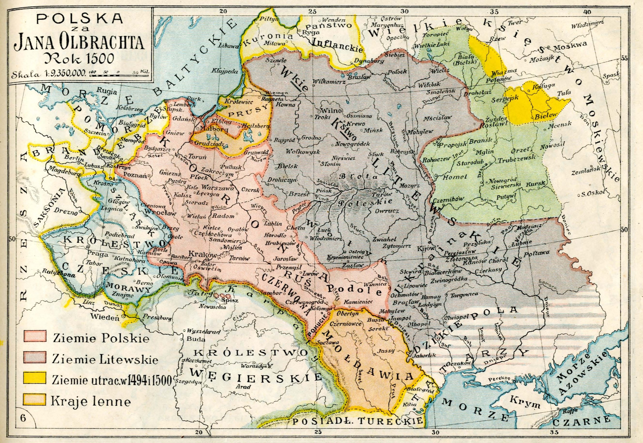
1500 Józef Michał Baze-
wicz: "POLSKA za Jana Ol-
brachta, Rok 1500," from
his 1918 "Atlas histor-
yczny Polski..." From www.
mapywig.org
wicz: "POLSKA za Jana Ol-
brachta, Rok 1500," from
his 1918 "Atlas histor-
yczny Polski..." From www.
mapywig.org


1586 Eligiusz Niewiadomski: "Polska za Stefana
Batorego," from his Atlas do dziejów Polski." From
www.mapywig.org
Batorego," from his Atlas do dziejów Polski." From
www.mapywig.org
1586 Józef M. Bazewicz:
"Polska u zczytu najwięk-
szej potęgi za Ste- fana
Batorego," from his 1918
"Atlas historyczny Polski."
From www.mapywig.org
"Polska u zczytu najwięk-
szej potęgi za Ste- fana
Batorego," from his 1918
"Atlas historyczny Polski."
From www.mapywig.org
1658 "Polish- Lith-
uanian-Ruthenian
Commonwealth."
From Wikimedia
uanian-Ruthenian
Commonwealth."
From Wikimedia
1635 ("Polish-Lithuanian
Commonwealth"), by
voivode. From Halibutt on
Wikimedia Commons
Commonwealth"), by
voivode. From Halibutt on
Wikimedia Commons

1635-86 Halibutt:
"Commonwealth: Lands
Lost 1657 - 86." From
Halibutt on wikimedia
"Commonwealth: Lands
Lost 1657 - 86." From
Halibutt on wikimedia

1677-99 Józef Michał
Bazewicz: "POLSKA po
rozejmie Andruszowsk,
1677 r.,," from his 1918
"Atlas historyczny
Polski." From www.
mapywig.org
Bazewicz: "POLSKA po
rozejmie Andruszowsk,
1677 r.,," from his 1918
"Atlas historyczny
Polski." From www.
mapywig.org


1673 Eligiusz Niewiadomski: "POLSKA po rozejmie
Andruszowskim i traktacie Buczackim, r. 1673"
(Poland following the treaties of Andrusovo and
Buczacz) from his "Atlas do dziejów Polski." From
www.mapywig.org
Andruszowskim i traktacie Buczackim, r. 1673"
(Poland following the treaties of Andrusovo and
Buczacz) from his "Atlas do dziejów Polski." From
www.mapywig.org

1780 "North &
East of Europe in
1780," published 1896.
From
www.periodpaper.com
East of Europe in
1780," published 1896.
From
www.periodpaper.com
1789 Mathiasrex: "Rzecz-
pospolita Obojga Narodów"
(Polish-Lithuanian Com-
monwealth), showing
administrative divisions
after the First Partition
pospolita Obojga Narodów"
(Polish-Lithuanian Com-
monwealth), showing
administrative divisions
after the First Partition

1618 Józef Michał Baze-
wicz: "POLSKA po pokoju
Dziewulinskim ZYGMUN-
TA III," from his 1918
"Atlas historyczny Polski."
From www.mapywig.org
wicz: "POLSKA po pokoju
Dziewulinskim ZYGMUN-
TA III," from his 1918
"Atlas historyczny Polski."
From www.mapywig.org
"Polish-Lithuanian
Commonwealth: 1773
-89" From
Halibutt onwikimedia
Commonwealth: 1773
-89" From
Halibutt onwikimedia

1618-19 Mathiasrex:
"Trude of Deulino," 2010,
showing lands gained by
the Grand Duchy. From
pl.wikipedia
"Trude of Deulino," 2010,
showing lands gained by
the Grand Duchy. From
pl.wikipedia
1770 Józef Michał
Bazewicz: "Mapa Polski z
podziałem na województwa
z 1770 r. oraz kilku
ważniejszych okresów"
(Map of Poland by province
in 1770 and several major
periods), Warsaw, c1917.
From www.polona.pl
Bazewicz: "Mapa Polski z
podziałem na województwa
z 1770 r. oraz kilku
ważniejszych okresów"
(Map of Poland by province
in 1770 and several major
periods), Warsaw, c1917.
From www.polona.pl


1771 Eligiusz Niewia-
domski: "Polska w XVIII
wieku" (...in the 18th
C.), from his 1920
"Atlas do dziejów Polski."
From www.mapywig.org
domski: "Polska w XVIII
wieku" (...in the 18th
C.), from his 1920
"Atlas do dziejów Polski."
From www.mapywig.org
1771 "Lietuvos Didžioji
Kunigaikštystės Admin-
istracinis Suskyrtimas..."
(Grand Duchy of Lithuania
Administrative divisions...),
From "Lietuvos Istorijos
Atlasas"
Kunigaikštystės Admin-
istracinis Suskyrtimas..."
(Grand Duchy of Lithuania
Administrative divisions...),
From "Lietuvos Istorijos
Atlasas"
1764 "POLAND - LITH-
UANIA - Physical." "
Polish Livonia" was
actually jointly-
administered "Polish-
Lithuanian Livonia."
From wikimedia
commons
UANIA - Physical." "
Polish Livonia" was
actually jointly-
administered "Polish-
Lithuanian Livonia."
From wikimedia
commons

1772 Jan Marcin Ban-
semer - Piotr Falkenhagen
Zaleski: "Poland in 1772
with its Principal Geo-
graphic Divisions," Kra-
kow, from "The Atlas con-
taining Ten Maps" From
www.easteurotopo.org
semer - Piotr Falkenhagen
Zaleski: "Poland in 1772
with its Principal Geo-
graphic Divisions," Kra-
kow, from "The Atlas con-
taining Ten Maps" From
www.easteurotopo.org

1772 Leonard Chodzko:
"Des Etats de l'Ancienne
Pologne...avat son premier
demembrement en 1772,"
Paris, 1831. From RCIN.org
"Des Etats de l'Ancienne
Pologne...avat son premier
demembrement en 1772,"
Paris, 1831. From RCIN.org

1772 Samuel Orgelbrand
(publisher): "Mappa Polski
za Stanisława Augusta w
roku 1772," Warsaw, 1849.
From igrek.amzp.pl/ maplist.
php?cat=POLHIST
(publisher): "Mappa Polski
za Stanisława Augusta w
roku 1772," Warsaw, 1849.
From igrek.amzp.pl/ maplist.
php?cat=POLHIST

1770-95 Eugeniusz
Romer "POLSKA w dobie
rozbiorow," Lwow, 1928, Instyut
Kartograficzny. From
www.easteurotopo.org
Romer "POLSKA w dobie
rozbiorow," Lwow, 1928, Instyut
Kartograficzny. From
www.easteurotopo.org

1771-95 "Res-
publikos Padaliji-
mai XVIII a Pabai-
goje," boundaries
in 1771, '72, ''93,
'95. From "Lietuvos
Istorijos Atlasas"
publikos Padaliji-
mai XVIII a Pabai-
goje," boundaries
in 1771, '72, ''93,
'95. From "Lietuvos
Istorijos Atlasas"

"Baltai XIII a Pradžioje"
(Baltic Peoples at the
Beginning of the 13th
century), Vilnius. From
Pradai"s "Mokyklinis Lietuvos
Istorijos Atlasas." (AK)
(Baltic Peoples at the
Beginning of the 13th
century), Vilnius. From
Pradai"s "Mokyklinis Lietuvos
Istorijos Atlasas." (AK)

1772 - 1815 Leonard Chodźko (after A.H. Dufour, and
dedicated to Joachim Lelewel): the 1815 map is titled:
"Das Land der Polen vor seiner ersten Theilung von1772
und im gegenwärtigen Stande seit 1815," Leipzig, 17.5 x
22 inches; while the 1831 version is titled "Des Etats de
l'Ancienne Pologne...," Paris, and covers the same
historical period.
dedicated to Joachim Lelewel): the 1815 map is titled:
"Das Land der Polen vor seiner ersten Theilung von1772
und im gegenwärtigen Stande seit 1815," Leipzig, 17.5 x
22 inches; while the 1831 version is titled "Des Etats de
l'Ancienne Pologne...," Paris, and covers the same
historical period.

1772 "Pierwszy rozbiór
Polski" (First Partition of
Poland), from "Polski
Atlas Kongresowy,"
1921.From RCIN.org
Polski" (First Partition of
Poland), from "Polski
Atlas Kongresowy,"
1921.From RCIN.org


1772-95 Eligiusz Niewiadomski: "Rozbiory Polski
r. 1772, 1793, 1795" (Partitions of Poland), from
the 1908 (left) and 1920 editions of his "Atlas do
Dziejów Polski..." A few more cities are identified
in the later version, but neither mention, by
design, anywhere, the Grand Duchy of Lithuania.
From www.mapywig.org
r. 1772, 1793, 1795" (Partitions of Poland), from
the 1908 (left) and 1920 editions of his "Atlas do
Dziejów Polski..." A few more cities are identified
in the later version, but neither mention, by
design, anywhere, the Grand Duchy of Lithuania.
From www.mapywig.org
1772-95 Carl Wolff: "Das
ehemalige Königreich
Polen nach den grenzen
von 1772, Mit Angabe der
Theilungslinien von
1772, 1793 & 1795,"
Hamburg, at 1:3 000
000, published 1872.
From RCIN.org
ehemalige Königreich
Polen nach den grenzen
von 1772, Mit Angabe der
Theilungslinien von
1772, 1793 & 1795,"
Hamburg, at 1:3 000
000, published 1872.
From RCIN.org

| 1772-95 Józef Michał Bazewicz: "Polska w czasie 3 rozbiorów" from his 1918 "Atlas historyczny Polski." Of note: no mention of "Lithuania," no "Vilnius" -- or "Wilno/ Wilna," either. From www. mapywig.org |

1501 - 1700 Leonard
Chodźko: "POLOGNE
aux XVI et XVII
siecles," after Lelewell.
From the British Library,
via Wikimedia
Chodźko: "POLOGNE
aux XVI et XVII
siecles," after Lelewell.
From the British Library,
via Wikimedia


1793 "Drugi rozbiór
Polski" (Second Partition of
Poland), from "Polski Atlas
Kongresowy," 1921.From
RCIN.org
Polski" (Second Partition of
Poland), from "Polski Atlas
Kongresowy," 1921.From
RCIN.org
1793 Jan Marcin Ban-
semer - Piotr Falkenhagen
Zaleski: "POLAND in
1793, after the second
Partition," 1837. From
www.easteurotopo.org
semer - Piotr Falkenhagen
Zaleski: "POLAND in
1793, after the second
Partition," 1837. From
www.easteurotopo.org
1795 Jan Marcin Ban- semer - Piotr
Falkenhagen Zaleski: "POLAND in 1795,
after the third Partition," 1837. From
www.easteurotopo.org
Falkenhagen Zaleski: "POLAND in 1795,
after the third Partition," 1837. From
www.easteurotopo.org

1795 "Trzeci rozbiór
Polski" (Third Partition of
Poland), from "Polski Atlas
Kongresowy," 1921. From
RCIN.org
Polski" (Third Partition of
Poland), from "Polski Atlas
Kongresowy," 1921. From
RCIN.org
1795 Gerard Lemaitre
(engraver): "Carte
Generale de la Pologne:
Anciennes Divisions;
Limites du Partage" Paris,
published 1835,
re-published 1840 by
Duvotenay. From
www.raremaps.com
(engraver): "Carte
Generale de la Pologne:
Anciennes Divisions;
Limites du Partage" Paris,
published 1835,
re-published 1840 by
Duvotenay. From
www.raremaps.com

[dated 1801] Jean-
Baptiste Poirson
(cartographer) - Pierre
Alexander Tardieu
(engraver): "Pologne
Avec les partages de
1792, 1793 et 1795..."
From www.swaen.com
Baptiste Poirson
(cartographer) - Pierre
Alexander Tardieu
(engraver): "Pologne
Avec les partages de
1792, 1793 et 1795..."
From www.swaen.com

Norman Davies: "The
Partitions of Poland
(1773-95)," from my
copy of his 2005 "God's
Playground: A History of
Poland."
Partitions of Poland
(1773-95)," from my
copy of his 2005 "God's
Playground: A History of
Poland."

1772-95 Rigobert Bonne :
"Carte du Royaume de
Pologne et du Grand Duche
de Lithuanie," from
Grenet's "Atlas Portatif."
From ruckizucki-prints on eBay
"Carte du Royaume de
Pologne et du Grand Duche
de Lithuanie," from
Grenet's "Atlas Portatif."
From ruckizucki-prints on eBay


Jan Babirecki: "Poland
in the 15th Century,"
from “Trzy mapy
Polski...” Warsaw,
published c1918 by
Gebethner & Wolff.
From http://rcin.org.pl
in the 15th Century,"
from “Trzy mapy
Polski...” Warsaw,
published c1918 by
Gebethner & Wolff.
From http://rcin.org.pl

1501-50 Jan Jakubowski:
"Wielkie Księstwo Litews-
kie w polowie XVI wieku"
(Grand Duchy of Lithuania,
iirst half of the 16th Cent.),
from 1928's "Atlas Histor-
yczny Polski. From wikimedia
/Podlaska Digital diary
"Wielkie Księstwo Litews-
kie w polowie XVI wieku"
(Grand Duchy of Lithuania,
iirst half of the 16th Cent.),
from 1928's "Atlas Histor-
yczny Polski. From wikimedia
/Podlaska Digital diary
1772 Jordan: "Mapa gen-
eral de Polonia: antes de
su desmembramiento,"
Barcelona, from Torner's
"Coleccion de Mapas
...antiquos y Modernos."
From the Spanish Ministry of
Defense: www.bibliotecavirtual
defensa.es
eral de Polonia: antes de
su desmembramiento,"
Barcelona, from Torner's
"Coleccion de Mapas
...antiquos y Modernos."
From the Spanish Ministry of
Defense: www.bibliotecavirtual
defensa.es
1772-95 "THE
PARTITION OF
POLAND,"1907.
From www. period
paper.com
PARTITION OF
POLAND,"1907.
From www. period
paper.com
1770 Bernardo Olivieri: "La
Polonia comme era nel 1770,"
Rome, 5.4 x 6.9 inches, from the
rare atlas "Atlante Tascabile..."
(Pocket Atlas), with an 1815
update to the Russian borders in
orange. From www.swaen.com
Polonia comme era nel 1770,"
Rome, 5.4 x 6.9 inches, from the
rare atlas "Atlante Tascabile..."
(Pocket Atlas), with an 1815
update to the Russian borders in
orange. From www.swaen.com

1795 Edme Mentelle - Pierre-Gilles
Chanlaire: "Carte de L'Ancien Royaume de
Pologne, Partage Entre La Russie, La
Prusse et L'Autriche Par les Traites
successis de 1772, 1793 et 1795," Paris,
24 x 16.5 inches. Two joined sheets. From
www.raremaps.com
Chanlaire: "Carte de L'Ancien Royaume de
Pologne, Partage Entre La Russie, La
Prusse et L'Autriche Par les Traites
successis de 1772, 1793 et 1795," Paris,
24 x 16.5 inches. Two joined sheets. From
www.raremaps.com
1701-18 Leonard
Chodzko: "Carte
Generale des Etats de
la Republique
Polonaise...et des
expeditions Charles
XII," Paris, published
1840. From wikimedia
Chodzko: "Carte
Generale des Etats de
la Republique
Polonaise...et des
expeditions Charles
XII," Paris, published
1840. From wikimedia

1258 - 1450 Ona
Maksimaitienė:
"Lietuvos Didžioji
Kunigaikštystė
XIIIa. -- XV a.
Viduryje" (The
Grand Duchy
of Lithuania,
from the XIII to
the middle of the
XVth century)."
From her "Lietuvos
Istorinės Geograf-
ijos Bruožai." (AK)
Maksimaitienė:
"Lietuvos Didžioji
Kunigaikštystė
XIIIa. -- XV a.
Viduryje" (The
Grand Duchy
of Lithuania,
from the XIII to
the middle of the
XVth century)."
From her "Lietuvos
Istorinės Geograf-
ijos Bruožai." (AK)


1226-60 and 1260 - 1410 "The State of the Teutonic
Order," showing boundaries and movements not only for
the Teutonic order, but for all the states in the Baltic
area. From wikimedia
Order," showing boundaries and movements not only for
the Teutonic order, but for all the states in the Baltic
area. From wikimedia


"Polska za Stanisława
Augusta r. 1764,"
published in 1824. From
The Wroblewski Library of the
Lithuanian Academy of
Sciences: elibrary.mab.lt/
Augusta r. 1764,"
published in 1824. From
The Wroblewski Library of the
Lithuanian Academy of
Sciences: elibrary.mab.lt/

1453 - 1772: Louis
Etienne Dussieux: Carte
pour servir a l'Histoire de
la Pologne..." Paris, from
his "Atlas General De
Geographie Physique,
Politique Et Historique."
From www.davidrumsey.com
Etienne Dussieux: Carte
pour servir a l'Histoire de
la Pologne..." Paris, from
his "Atlas General De
Geographie Physique,
Politique Et Historique."
From www.davidrumsey.com

1370 Eligiusz Niewi-
adomski: "Polska za
Kazimierza Wielkiego,"
from the 1920 "Atlas
do Dziejów Polski." From
www.mapywig.org
adomski: "Polska za
Kazimierza Wielkiego,"
from the 1920 "Atlas
do Dziejów Polski." From
www.mapywig.org

1139 Joachim Lelewl:
("Poland divided by
Boleslav III"), published
1865. From wikimedia
("Poland divided by
Boleslav III"), published
1865. From wikimedia


1634 "Karta Pol'shi na
plane osady Smolenska
1634" (Map of Poland on
the plan of a siege of
Smolensk, 1634), Kiev,
published 1899 by S.V.
Kulʹzhenko. The New York
Public Library's digital collection
plane osady Smolenska
1634" (Map of Poland on
the plan of a siege of
Smolensk, 1634), Kiev,
published 1899 by S.V.
Kulʹzhenko. The New York
Public Library's digital collection
1771 Étienne André
Philippe de Prétot -
Maurille Antoine
Moithey: "Carte Nou-
velle de la Pologne,
Avant son demnmbre-
ment," Paris, engraved by
J.E.J. Vallet, from, his 1878
"Atlas universel..." From
www.raremaps.com
Philippe de Prétot -
Maurille Antoine
Moithey: "Carte Nou-
velle de la Pologne,
Avant son demnmbre-
ment," Paris, engraved by
J.E.J. Vallet, from, his 1878
"Atlas universel..." From
www.raremaps.com


1771 - Pre-Partition (dated 1831)
M. Herrison (mapmaker, after
Sanson): "Carte des États de Pologne
et du Grand Duché de Lithuanie..,"
Paris, 70.4 x 53.7 cm. From cesgia on
eBay
M. Herrison (mapmaker, after
Sanson): "Carte des États de Pologne
et du Grand Duché de Lithuanie..,"
Paris, 70.4 x 53.7 cm. From cesgia on
eBay

G. Haas (engraver/mapmaker) - Malte - Brun
(publisher): "Carte des Partages de la Pologne en 1772,
1793, et 1795." The first edition was a stand-alone
map, published in Basel. The second edition was
published in Paris and Basle, 27 x 32 cm, in
"Geographie Mathematique, Physique et Politique." The
only differences between the two are in the cartouche.

862 (Russian History
Map), 862 being the
traditional founding date
of Russia. Shows "Litva"
as a separate entity,
including "Zhmud." From
www.globalsecurity.org
Map), 862 being the
traditional founding date
of Russia. Shows "Litva"
as a separate entity,
including "Zhmud." From
www.globalsecurity.org

| Published 1815 www.raremaps.com |

1392 - 1430 Antoine
Viscont: "Lituanie sous le
règne du grand duc
Vytautas (Vitold),"
c1918, on linen, in
Geneva. From
east_euro_maps on eBay
Viscont: "Lituanie sous le
règne du grand duc
Vytautas (Vitold),"
c1918, on linen, in
Geneva. From
east_euro_maps on eBay
1772-95 Robert de
Vaugondy Family
(original mapmaker) -
Charles Delamarche -
(creator of this updated
version): "Carte generale
du theatre de la guerre
en Pologne," Paris,
published 1807. From
www.geographicus.com
Vaugondy Family
(original mapmaker) -
Charles Delamarche -
(creator of this updated
version): "Carte generale
du theatre de la guerre
en Pologne," Paris,
published 1807. From
www.geographicus.com


1560 Ward:
"Eastern
Baltic..."
from "The
Cambridge
Modern
History
Atlas." From
Perry-
Castañeda
Library
"Eastern
Baltic..."
from "The
Cambridge
Modern
History
Atlas." From
Perry-
Castañeda
Library

W. Shepherd:
"Growth of Russia,
1300- 1796," 1926.
www.lib.utexas.edu
"Growth of Russia,
1300- 1796," 1926.
www.lib.utexas.edu
1328 - 1462: "IV РУСЪ"
(Russia), showing
"няжество Литовское"
(Duchy of Lithuania).
From smardic on eBay
(Russia), showing
"няжество Литовское"
(Duchy of Lithuania).
From smardic on eBay


900 - 1795 Józef M. Baze-
wicz: "Polska w Trzech Za-
borach w Granicach Prze-
drozbiorowych w 1770
..." (Poland in three parti-
tions...), Warsaw, c1922.
From Antiquariat Daša Pahor
http://www.pahor.de
wicz: "Polska w Trzech Za-
borach w Granicach Prze-
drozbiorowych w 1770
..." (Poland in three parti-
tions...), Warsaw, c1922.
From Antiquariat Daša Pahor
http://www.pahor.de

1454-56 "POLSKA I
LITWA W XV WIEKU"
(POLAND AND
LITHUANIA IN THE 15TH
CENTURY). From
http://histoirespolonaises.
blogspot.com
LITWA W XV WIEKU"
(POLAND AND
LITHUANIA IN THE 15TH
CENTURY). From
http://histoirespolonaises.
blogspot.com
| Published 1854 |
| Published 1855 www.davidrumsey.com |
| www.dspace.utlib.ee/dspace |
| National Library of Latvia via the European Library.org |
| Published 1908 |
| Published 1920 |
| Published 1908 |
| Published 1920 |
| www.swaen.com |
| boughettiarte on eBay |
| Published 1831 RCIN via www. easteurotopo.org |
1772-95 Louis
Dussieux: "Carte pour
servir a l'histoire de la des
Demembrements de la
Pologne," Paris, 21 x 26
cm, published 1856 in his
"Atlas General De Geo-
graphie Physique, Poli-
tique Et Historique." From
www.davidrumsey.com
Dussieux: "Carte pour
servir a l'histoire de la des
Demembrements de la
Pologne," Paris, 21 x 26
cm, published 1856 in his
"Atlas General De Geo-
graphie Physique, Poli-
tique Et Historique." From
www.davidrumsey.com
| Second Edition, 1804 www.davidrumsey.com |
| First Edition, c1800 www.raremaps.com |


1756-62 Halibut
(mapmaker): "Actions of
the Imperial Russian
Army 1756-1762 during
the Seven Years' War."
From wikimedia
(mapmaker): "Actions of
the Imperial Russian
Army 1756-1762 during
the Seven Years' War."
From wikimedia
1569 "Grand Duchy
of Lithuania..." From
http://
www.ornatowski.com/
of Lithuania..." From
http://
www.ornatowski.com/


1771 [published c. 1860]
Francesco Pagnoni:
"Regno di Polonia nei suoi
antichi confini avanti lo
smembramento (...in its
ancient borders before
dismemberment), Milan,
16.2 x 12.7 inches. From
www.raremaps.com
Francesco Pagnoni:
"Regno di Polonia nei suoi
antichi confini avanti lo
smembramento (...in its
ancient borders before
dismemberment), Milan,
16.2 x 12.7 inches. From
www.raremaps.com
Depcting the July 5, 1757 siege
of Memel by Russian troops and
ships: "Siege de Memel: par les
Russes aux ordres général de
Fermer le 19 Juin au 5 Juillet
1757 / dessiné par Therbu
lieutenant ingenieur; Gravé par
Cöntgen graveur de la cour et de
l’Univerdité de Mayence
[Mainz]." Published 1790. The
siege was during the global
Seven Years War, 1756-63,
where, in this part of the conflict,
Russia was attacking East
Prussia. From The Wroblewski
Library of the Lithuanian Academy of
Sciences: http://www.mab.lt


Karola Miarki (publisher):
"Mapa Polski w granicach
z. r. 1772..." (Map of
Poland within the limits of
1772, for the memory of
the 100-year anniversary
of the Third Partition of
Poland), Mikołów,
published 1895. From
worldantiques on eBay
"Mapa Polski w granicach
z. r. 1772..." (Map of
Poland within the limits of
1772, for the memory of
the 100-year anniversary
of the Third Partition of
Poland), Mikołów,
published 1895. From
worldantiques on eBay


John Cooke: (engraver/map-
maker/ publisher): "Poland,"
London, 5.5 x 5.5 inches,
showing the "dismember-
ments" of 1772, 1793 and
1795, published 1801 [dated].
From www.raremaps.com
maker/ publisher): "Poland,"
London, 5.5 x 5.5 inches,
showing the "dismember-
ments" of 1772, 1793 and
1795, published 1801 [dated].
From www.raremaps.com

1582 Władysław Semko-
wicz: "Carte de la Répub-
lique de Pologne..,"
Warsaw, 1934. From
Cartographic and Geological
Inst. of Catalonia: www.carto
tecadigital.icc cat/cdm/
wicz: "Carte de la Répub-
lique de Pologne..,"
Warsaw, 1934. From
Cartographic and Geological
Inst. of Catalonia: www.carto
tecadigital.icc cat/cdm/

1308 - 1455 "Teutonic
State." From wikipedia
State." From wikipedia
1501 - 1700
"Россия - XVI и
XVII веки..."
(Russian expansion)
From Library of Con-
gress: www.loc.gov
"Россия - XVI и
XVII веки..."
(Russian expansion)
From Library of Con-
gress: www.loc.gov
1569 - 1795
Ona Maksi-
maitienė:
"Lietuvos
Didžioji Kuni-
gaikštystė,"
from her
"Lietuvos
Istorinės
Geografijos
Bruožai."
(AK)
Ona Maksi-
maitienė:
"Lietuvos
Didžioji Kuni-
gaikštystė,"
from her
"Lietuvos
Istorinės
Geografijos
Bruožai."
(AK)
1413 - 1564 Ona
Maksimaitienė:
"Lietuvos Didžioji
Kunigaikštystė."
From "Lietuvos
Istorinės Geografi-
jos Bruožai."(AK)
Maksimaitienė:
"Lietuvos Didžioji
Kunigaikštystė."
From "Lietuvos
Istorinės Geografi-
jos Bruožai."(AK)


| "Poland and Lithuania before the 1569 Union of Lublin” |
| "Poland and Lithuania after the 1569 Union of Lublin” |
Reginald Lane Poole (historian), from his 1902 "Historical
Atlas of Modern Europe..," Oxford, London and New York.
Both images: https://www.flickr.com/photos/uconnlibrariesmagic/
Atlas of Modern Europe..," Oxford, London and New York.
Both images: https://www.flickr.com/photos/uconnlibrariesmagic/


1771 [dated 1907]
"Rzeczpospolita Polska
przed Rozbiorami" (The
Republic of Poland before
the Partitions), Kraków,
140 x 180 mm postcard.
From www.archiwum.
allegro.pl
"Rzeczpospolita Polska
przed Rozbiorami" (The
Republic of Poland before
the Partitions), Kraków,
140 x 180 mm postcard.
From www.archiwum.
allegro.pl
1807 Luigi Rossi (publisher) - Alexandre
Blondeau (engraver): "LA POLOGNEE
AVEC LES PARTAGES 1772, 1793 et
1795," Paris, from "Atlas universal pour
la geographie de Guthrie." From
www.swaen.com
Blondeau (engraver): "LA POLOGNEE
AVEC LES PARTAGES 1772, 1793 et
1795," Paris, from "Atlas universal pour
la geographie de Guthrie." From
www.swaen.com

c. 13th cent. Louis
Etienne Dussieux: ("Map
for use in the historyof
Poland and the Teutonic
Order..."), Paris, from
1856's "Atlas General."
www.davidrumsey.com
Etienne Dussieux: ("Map
for use in the historyof
Poland and the Teutonic
Order..."), Paris, from
1856's "Atlas General."
www.davidrumsey.com

1270 Hipte Bonvalet
(engraver) - Achille
Meissas, Auguste Michelot
(mapmakers/publishers):
"Europe vers l'An 1270."
From www.davidrumsey.com
(engraver) - Achille
Meissas, Auguste Michelot
(mapmakers/publishers):
"Europe vers l'An 1270."
From www.davidrumsey.com

| Dated 1823 www.davidrumsey.com |
| Dated 1834 www.polona.pl |

964 - 1830 Duval (1618-
83, original mapmaker) -
Houbloup (publisher):
"Tableau l'historie des
Royaumes de Pologne..,"
Paris, 40 x 57 cm, from
"Atlas Universel
d'Histoire..." From
www.davidrumsey.com
83, original mapmaker) -
Houbloup (publisher):
"Tableau l'historie des
Royaumes de Pologne..,"
Paris, 40 x 57 cm, from
"Atlas Universel
d'Histoire..." From
www.davidrumsey.com
1674-96 J. Szpet-
kowski: "Mapa Polski
za Panowania króla
Jana Sobieskiego ..."
(Map of Poland during
the reign of King Jan
Sobieski), Poznań.
From www.mapywig.org
kowski: "Mapa Polski
za Panowania króla
Jana Sobieskiego ..."
(Map of Poland during
the reign of King Jan
Sobieski), Poznań.
From www.mapywig.org

| 1700-09 |
| 1709-21 |

1683 [dated 1904]
Franciszek Namysłowski
(priest/mapmaker):
"Magdaleniczna Mapa
Polska," Kraków, depicting
Catholic churches and
holy sites, and Poles
defeating the Ottomans.
From Steve Seegel
Franciszek Namysłowski
(priest/mapmaker):
"Magdaleniczna Mapa
Polska," Kraków, depicting
Catholic churches and
holy sites, and Poles
defeating the Ottomans.
From Steve Seegel

Karl von Spruner
(cartographer) - Justus
Perthes (publisher):
"Volker und Reiche der
Slaven zwischen Elbe und
Don bis 1125," Gotha,
London, from the 1855
"Histor. Atlas."
www.davidrumsey.com
(cartographer) - Justus
Perthes (publisher):
"Volker und Reiche der
Slaven zwischen Elbe und
Don bis 1125," Gotha,
London, from the 1855
"Histor. Atlas."
www.davidrumsey.com


(Anonymous) 19th century maps, dissected and linen-backed, published in Germany,
depicting the Polish-Lithuanian Commonwealth before the Partiions, after the First,
1772 Partiion, nd after the Second, 1793 Partition. See the "...im Jahre 1796" version
at the (MapsHistoricalAfter1795) page. All sourced from www.polonia.pl
depicting the Polish-Lithuanian Commonwealth before the Partiions, after the First,
1772 Partiion, nd after the Second, 1793 Partition. See the "...im Jahre 1796" version
at the (MapsHistoricalAfter1795) page. All sourced from www.polonia.pl
| "Polen Litauen und Kurland" |
| "Polen Litauen und Kurland im Jahr 1775" |
| "Polen Litauen und Kurland im Jahr 1793" |


1320-70 Józef Mitkow-
ski (mapmaker) - Pan-
stwowe Przedsiębiorstwo
Wydawnictw Kartografi-
cznych: "Krolestwo Polskie
i Wielkie Księstwo
Litewskie." From https:
//collections.lib.uwm.edu/
ski (mapmaker) - Pan-
stwowe Przedsiębiorstwo
Wydawnictw Kartografi-
cznych: "Krolestwo Polskie
i Wielkie Księstwo
Litewskie." From https:
//collections.lib.uwm.edu/

| www.kettererkunst.de |

1386 - 1434 "Poznaniak"
(mapmaker): "Polska i
Litwa za panowania
Władysława II Jagiełły
(Jogaila). From "Ilustrowany
atlas historii Polski, wyd.
Demart, Warszawa & wikipedia
(mapmaker): "Polska i
Litwa za panowania
Władysława II Jagiełły
(Jogaila). From "Ilustrowany
atlas historii Polski, wyd.
Demart, Warszawa & wikipedia

1793 "Podział admin-
istracyjny Rzeczypos-
politej Obojga Narodów
w 1793 (Województwa
utworzone w sejmie
grodzieńskim)" (Admin-
istrative division of the
Polish-Lithuanian Com-
monwealth in 1793
[voivodships created at
the Grodno Seym] --
following the Second,
1793, Partition of the
Commonwealth. From
wikipedia
istracyjny Rzeczypos-
politej Obojga Narodów
w 1793 (Województwa
utworzone w sejmie
grodzieńskim)" (Admin-
istrative division of the
Polish-Lithuanian Com-
monwealth in 1793
[voivodships created at
the Grodno Seym] --
following the Second,
1793, Partition of the
Commonwealth. From
wikipedia

1654-67 Andrej Kotljar-
chuk, Viktor Temushev
(mapmakers): "The Grand
Duchy of Lithuania and its
administrative, geograph-
ical and religious divisions."
From Kotljarchuk's 2006 doctoral
dissertation at Södertörn Univ.,
Stockholm
chuk, Viktor Temushev
(mapmakers): "The Grand
Duchy of Lithuania and its
administrative, geograph-
ical and religious divisions."
From Kotljarchuk's 2006 doctoral
dissertation at Södertörn Univ.,
Stockholm

"Fernhandelsstraß-
en und Wander-
ungswege in Ost-
europa...") (...trade,
migration routes in
Eastern Europe...
9th to 11th cent's)
wikimedia
en und Wander-
ungswege in Ost-
europa...") (...trade,
migration routes in
Eastern Europe...
9th to 11th cent's)
wikimedia

c. 1771 "POLAND," prob-
ably London, with unique
variants - misspellings? -
of town names, created in
the early 19th century
with city spelling errors.
From L'Institut Cartogràfic i
Geològic de Catalunya: https://
cartotecadigital.icgc.cat/digital/
ably London, with unique
variants - misspellings? -
of town names, created in
the early 19th century
with city spelling errors.
From L'Institut Cartogràfic i
Geològic de Catalunya: https://
cartotecadigital.icgc.cat/digital/

Zbigniew Rzepa (editor) -
Panstwowe Przedsiębiorst-
wo Wydawnictw Kartograf-
icznych: "Królestwo Polskie
i Wielkie. Księstwo Litew-
skie w latach 1370-1505,"
Wrocław, 146 x 167 cm.
From University of Wisconsin,
Milwaukee, Libraries: https:
//collections.lib.uwm.edu/
Panstwowe Przedsiębiorst-
wo Wydawnictw Kartograf-
icznych: "Królestwo Polskie
i Wielkie. Księstwo Litew-
skie w latach 1370-1505,"
Wrocław, 146 x 167 cm.
From University of Wisconsin,
Milwaukee, Libraries: https:
//collections.lib.uwm.edu/

1771 [published 1830] Rest
Fenner (engraver) - Robt
Jennings (publisher):
"Poland Previous to its
First partition in 1772,"
London, from Fenner's
Pocket Atlas, of Modern &
Ancient Geography."
From www.davidrumsey.com
Fenner (engraver) - Robt
Jennings (publisher):
"Poland Previous to its
First partition in 1772,"
London, from Fenner's
Pocket Atlas, of Modern &
Ancient Geography."
From www.davidrumsey.com
