Maps: 1710 - 1714
1710 Henri Abraham
Chatelain: "POLOGNE
LITHUANIE"
Chatelain: "POLOGNE
LITHUANIE"


1710 Charles Inselin:
"ROYAUME DE POLOGNE,"
21 x 28 inches. From
www.mapmogul.com
"ROYAUME DE POLOGNE,"
21 x 28 inches. From
www.mapmogul.com

1710 Gerard van Keulen (engraver/publisher): "REGNI POLONIÆ et Ducatus
Lithuaniæ..," Amsterdam, 51.2 x 61.0 cm.
Lithuaniæ..," Amsterdam, 51.2 x 61.0 cm.
1711 Francisco Laso:
"ESTADOS DE LA
CORONA DE POLON-
IA," Madrid, 5 1/4 x 5
7/8 inches, from "El
Atlas Abreviato,"
whose plates were
based on those of Don
Francisco De Affer-
den’s 1696 atlas
published in Ant-
werp -- itself based on
Jacques Peeters' 1692
"L'Atlas En Abrege."
published in 1692.
From Vilnius Univ.
Library: http://www.
atmintis.mb.vu.lt/

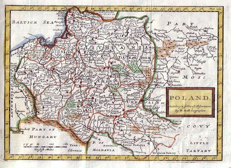

c. 1711 Herman Moll: "POLAND, According to neweft obfervations," London, 7.25 x 10 inches, from his "Complete
System of Geography." In four different versions, published the same year.
System of Geography." In four different versions, published the same year.

1711 Philipp Clüver: "Veterius et Novæ REGNI POLONIÆ Magniq Ducatus, LITHUANIÆ
Cum suis Palatinatibus ac Consinus Descriptio." London, 10 x 8.2 inches / 25.4 x 20.9
cm, in, first the "English" state of the plate, from "Introductio in Universam
Geographicam" published by John Nicholson, and then two versions of the second "Latin"
state of the plate, published elsewhere the same year.
1711 Guillaume Delisle - Johannes van Lugtenburg/ Luchtenburgh (engraver) - Henri
Scheurleer (publisher): "Livonie, Curlande, et Samogitie." The Hague. Published in
"Theatre Complet et Particularise De La Guerre Du Nort [Great Northern War] Ou Cartes
Geographiques Des Pais exposez a la presente Guerre."
Scheurleer (publisher): "Livonie, Curlande, et Samogitie." The Hague. Published in
"Theatre Complet et Particularise De La Guerre Du Nort [Great Northern War] Ou Cartes
Geographiques Des Pais exposez a la presente Guerre."


1713-14 Pieter van der Aa: "La LIVONIE Avec les frontieres de COURLANDE, et de FINLANDE..," Leiden, 29 x 36cm /
11.2 x 14 inches, in four iterations of the first edition of his "Nouvel Atlas."
11.2 x 14 inches, in four iterations of the first edition of his "Nouvel Atlas."
1714 Henri Chatelain (engraver, after
Delisle) - Nicolas Gueudeville (commentary)
- François l’Honoré & Cie; Frères Châtelain
(publishers): "CARTE DE POLOGNE AVEC
LA CHRONOLOGIE DES ROIS ET DES DUCS
DE LITHUANIE..," Amsterdam, from the
First Edition of Tome (Volume) IV of "Atlas
Historique." The Second Edition was
published 1718; Third: 1720; Fourth and
last: 1735. From www.davidrumsey.com
1711 Petrus Schenk:
"Polon. Lithuan..," 57 x
47 cm. From Staats- und
Universitätsbibliothek
Bremen via europeana.eu
"Polon. Lithuan..," 57 x
47 cm. From Staats- und
Universitätsbibliothek
Bremen via europeana.eu
1714 Henri Chatelain (engraver, after Delisle) - Nicolas Gueudeville (commentary) -
François l’Honoré & Cie; Frères Châtelain (publishers): "NOUVELLE CARTE DU ROYAUME
DE POLOGNE..," Amsterdam, from the First Edition of Tome (Volume) IV of "Atlas
Historique." The Second Edition was published 1718; Third: 1720; Fourth and last: 1735.
François l’Honoré & Cie; Frères Châtelain (publishers): "NOUVELLE CARTE DU ROYAUME
DE POLOGNE..," Amsterdam, from the First Edition of Tome (Volume) IV of "Atlas
Historique." The Second Edition was published 1718; Third: 1720; Fourth and last: 1735.


c. 1710 Daniel de la Feuille (publisher):
"LA LIVONIE," 8.5 x 6 inches, from "Les
Tablettes Guerrières..." (military atlas),
Amsterdam. www.oldworldauctions.com
"LA LIVONIE," 8.5 x 6 inches, from "Les
Tablettes Guerrières..." (military atlas),
Amsterdam. www.oldworldauctions.com
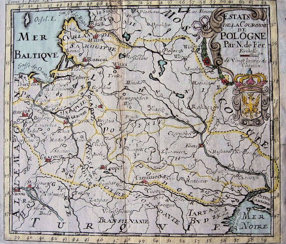
1714 Nocolas de Fer :
"ESTATS de la Couronne
de POLOGNE," Paris, 5 1/2
x 6 1/4 inches / 13.7 x
15.7 cm, from the sixth
edition of Jacques Robbe's
"Methode pour apprendre
facilement la Geographie
..." From mappamundi-fr on
eBay
"ESTATS de la Couronne
de POLOGNE," Paris, 5 1/2
x 6 1/4 inches / 13.7 x
15.7 cm, from the sixth
edition of Jacques Robbe's
"Methode pour apprendre
facilement la Geographie
..." From mappamundi-fr on
eBay

1712 Edward Wells (geographer) - Simon Nicholls (engraver): "A New Map of Present
Poland, Hungary, Walachia, Moldavia, Little Tartary &c. Shewing thier Principall
Divisions Chief Cities, Towns, Rivers, &c.," Oxford, 20 x 14.5 inches, in versions from an
atlas, published from 1700 - 1738, dedicated to 11-year-old William, Duke of Gloucester,
who had just died while attending school in Oxford. The map is from "A Treatise of antient
and present Geography, together with a sett of maps in folio." See the 1700 version.

1712 Johann Baptiste Homann (engraver): "Regni Poloniæ Magnique Ducatus Lithuaniæ nova et exacta ad mentem Starovolcii descripta," Nuremberg, 19 3/8 x 22 ½ inches, in versions of the First State, identified by the presence of
“Author sculpsit” at the lower right. "Norimbergae" below Homann's name also distinguishes this plate of a map which underwent many minor changes over the years. Later states: #2: 1715-18; #3: 1729; #4: 1730-38; #5: 1739.
“Author sculpsit” at the lower right. "Norimbergae" below Homann's name also distinguishes this plate of a map which underwent many minor changes over the years. Later states: #2: 1715-18; #3: 1729; #4: 1730-38; #5: 1739.

1710-11 Gerard & Leonard Valk (engravers/publishers): "Regnum Poloniӕ divisum in Magnum Ducatum Lithuaniæ, Magnum parvam que Poloniam, Prussiam, albam et rubram Russiam, Volhyniam, Podoliam,
Ukraniam...per Gerard et Leonard Valk. Amst. cum Privilegio," Amsterdam.
Ukraniam...per Gerard et Leonard Valk. Amst. cum Privilegio," Amsterdam.
1714 Henri Chatelain (engraver, after
Delisle) - Nicolas Gueudeville (commentary)
- François l’Honoré & Cie; Frères Châtelain
(publishers): "Carte Genealogique Des
Princes Et Rois De Pologne Et Des Familles
Roiales Et Ducales De Piaste Et De
Iagelon..." (Map of the Genealogy of the
Princes and Kings of Poland and their Royal
Families, as well as of the Piaste and
Jagiellonian dynasties...)," Amsterdam, 15.5
x 37 inches, with two inset maps, from the
First edition of Tome (Volume) IV of "Atlas
Historique." The Second Edition was
published 1718; Third: 1720; Fourth and
last: 1735. From www.davidrumsey.com


c. 1710 - 1714 Christoph Weigel: "Poloniæ & Lithvania
accurante curatius," Nuremberg, 13.5 x 11 inches. See
the 1718 version.
accurante curatius," Nuremberg, 13.5 x 11 inches. See
the 1718 version.

1714 Claude Buffier - Abraham Du Bois (engraver/
publisher): "La Pologne suivant les degrés de l'academie
des sciences de Paris," the left image. The right: from
"De la Geographie moderne d'Abraham Du Bois," Leiden.
publisher): "La Pologne suivant les degrés de l'academie
des sciences de Paris," the left image. The right: from
"De la Geographie moderne d'Abraham Du Bois," Leiden.

1711 Antoine Menard (engraver/map-
maker) - Jacques Chiquet (publisher):
"Les Estats de la Couronne de
POLOGNE," Paris, 6.5 x 8.7 inches,
from the first edition of "Le Nouveau
et Curieux Atlas Geographique et
Historique..." In 1719, Chiquet
replaced all mention of Menard and
republished the atlas under his own
name. From www.swaen.com

Before 1710 Frederick de
Wit: "Reipublicæ et Status
Generalis POLONIÆ..."
Amsterdam, in the third
state. From www.vobam.se
Wit: "Reipublicæ et Status
Generalis POLONIÆ..."
Amsterdam, in the third
state. From www.vobam.se

1711 Charles-Hubert
Jaillot (mapmaker, up-
dating Sanson - Pierre
Mortier (publisher): "Estats
de Pologne Subdivisés..."
Amsterdam, 5th edition.
From www.vobam.se
Jaillot (mapmaker, up-
dating Sanson - Pierre
Mortier (publisher): "Estats
de Pologne Subdivisés..."
Amsterdam, 5th edition.
From www.vobam.se

| Lithuanian National Museum: www.lnm.lt |
| Royal Danish Library: www.kb.dk |
| Royal Danish Library: www.kb.dk |
| vilkau on eBay |
| andrisz2005 on eBay |
| "English" Plate www.mapmogul.com |
| www.oldworldauctions.com |
| www.mapmogul.com |
| Beinecke Rare Book Library: www.brbl-dl.library.yale.edu |
| www.martayanLan.com |
| www.raremaps.com |
| National Library of Estonia: www.nlib.ee/en |
| gkrgrec on eBay |
| Univ. of Tartu: http://dspace.ut.ee/ |

c. 1710 Renier and Joshua Ottens
(publishers) - Jacob Keyser (engraver):
"Reipublicæ et status generalis Poloniæ
nova Tabula comprehendens Maioris et
minoris Poloniæ Regni..," Amsterdam,
20.1 x 34.3 inches. / 51.0 x 87.0 cm., in
two joined sheets. From www.swaen.com
(publishers) - Jacob Keyser (engraver):
"Reipublicæ et status generalis Poloniæ
nova Tabula comprehendens Maioris et
minoris Poloniæ Regni..," Amsterdam,
20.1 x 34.3 inches. / 51.0 x 87.0 cm., in
two joined sheets. From www.swaen.com

| www.raremaps.com |
| https://antique-maps.lt/ |


| Royal Danish Library: |

1714 Pieter van der Aa (mapmaker/publisher): "LA POLOGNE, Suivant les Nouvelles
Observations de Messrs. de l'Academie Royale des Sciences,..," Leiden, 8.7 x 11.5 inches,
from the first edition of his "NOUVEL ATLAS très Exact et Fort Commode pour Toutes Sortes
de Personnes, Contenant LES PRINCIPALES CARTES GÉOGRAPHIQUE"... See the 1719
version of this map. Before Pieter died in 1733, he sold the plates for this atlas to Covens &
Moritier, who reissued the atlas in 1735, replacing van der Aa's name with their own.

| www.sanderusmaps.com |
| wikimedia |

| www.sanderusmaps.com |
| www.raremaps.com |

| www.raremaps.com |

| www.swaen.com |
| Cartographic and Geological Institute of Catalonia: www.cartotecadigital.icc.cat/ |

Later re-engraved, labels changed from
Spanish to French, in the 1758 Bachiene/
Covens et Mortier "ESTATS de la
COURONNE de POLOGNE."
Spanish to French, in the 1758 Bachiene/
Covens et Mortier "ESTATS de la
COURONNE de POLOGNE."
| Univ. of Basel via europeana.eu |
| www.raremaps.com |


| www.mapywig.org |


| Univ. of Wisconsin, Milwaukee Libraries: www.collections.lib.uwm.edu |


1714 Title page of the
First Edition of Tome
(Volume) IV of "Atlas
Historique," from which
the following three
Châtelain maps came.
From www.davidrumsey.com
First Edition of Tome
(Volume) IV of "Atlas
Historique," from which
the following three
Châtelain maps came.
From www.davidrumsey.com
| Tome 4: No. 20 |
| Tome 4: No. 21 www.davidrumsey.com |
| Tome 4: No. 25 |
| Univ. of Wisconsin, Milwau- kee, Libraries: www.collections.lib.uwm.edu/ |

| www.swaen.com |

| Yale’s Beinecke Library: https: //brbl-dl.library.yale.edu |

| National Librry of Estonia:www.nlib.ee |
| National Librry of Estonia:www.nlib.ee |

| Lithuania Poland Maps: www.lpmaps.lt |

1711 Guillaume Delisle -
Johannes van Lugtenburg
(engraver) - Henri
Scheurleer (publisher):
"Grand Duche de
Lithuanie..," The Hague.
Published in "Theatre
Complet et Particularise
De La Guerre Du Nort..."
From www.lpmaps.lt
Johannes van Lugtenburg
(engraver) - Henri
Scheurleer (publisher):
"Grand Duche de
Lithuanie..," The Hague.
Published in "Theatre
Complet et Particularise
De La Guerre Du Nort..."
From www.lpmaps.lt

c. 1710 Frederick de
Wit (revising
engraver/publisher)
- Pieter Mortier
(recent publisher):
"Ducatuum Livoniæ
et Curlandiæ Nova
Tabula..," Amster-
dam, 49 x 41 cm.
From www.digar.ee
Wit (revising
engraver/publisher)
- Pieter Mortier
(recent publisher):
"Ducatuum Livoniæ
et Curlandiæ Nova
Tabula..," Amster-
dam, 49 x 41 cm.
From www.digar.ee

| University of Vilnius Library: https://kolekcijos.biblioteka.vu.lt/ |

1713 Pieter van der Aa (publisher): "LA
POLOGNE..," Leiden, Amsterdam, from his
"Le Nouveau Theatre du Monde, ou la
Geographie Royale composée de nouvelles
cartes tres-exactes..,” which had "frames"
on the plate of each map. See the 1700 and
1719 versions. From the Library of the Univ. of
Vilnius: https://kolekcijos.biblioteka.vu.lt/
POLOGNE..," Leiden, Amsterdam, from his
"Le Nouveau Theatre du Monde, ou la
Geographie Royale composée de nouvelles
cartes tres-exactes..,” which had "frames"
on the plate of each map. See the 1700 and
1719 versions. From the Library of the Univ. of
Vilnius: https://kolekcijos.biblioteka.vu.lt/

| Second "Latin" Plate |

| NEW March 30 |
| Tome 4: No. 21 www.swaen.com |