Maps Ethnographic: 1500 years of categorization (by mapmakers from
roughly 1840 on) of the peoples in the historic Lithuanian area by ethnicity, language
and/or religion -- mostly to their disadvantage, and created primarily to advance a
particular group's political aims and claims.
After the last partition of Poland-Lithuania in 1795, according to Steve Seegel, in "Mapping Europe's Borderlands" (Univ. of Chicago
Press, 2012), it was the explicit policy of Catherine of Russia to eliminate any trace of the Commonwealth from history: Poles,
Lithuanians, Latvians,Estonians, Belarusians, and Ukrainians all became mere tribes that benefited by Russian acquisition -- or even by
returning to Russian rule. By the middle and late 19th century, patriotic Poles began erasing the name "Lithuania" from historic maps of
the area, referring to it only as "Poland,' and to Lithuanians as merely one of many tribes within Poland, sometimes with no recognition
that they weren't Slavs. Meanwhile, Russian mapmakers characterized Belarusians as "White" Russians, and Ukrainians as "Little"
Russians. Nationalistic Lithuanians picked up the drumbeatin the early 19oo's, and some, even today refer to Belarusians as Lithuanians
who have merely forgotten that they are really Lithuanian. And Belarusians? On some contemporary map sites they consider
themselves the true inheritors of the Commonwealth, and claim that the Grand Duchy was, in fact, a Belarusian state. All of which had --
and have -- consequences for how post World War I countries were delimited, and for contemporary politics, most obviously in Ukraine.
Maps by date depicted, not date created
701 - 900 DETAIL
from"Slavic Peoples, VIII -
IXc," from a 1923 historical
atlas using Polish
nomenclature. Are
"Lithuanians" "Slavic
Peoples"?
from"Slavic Peoples, VIII -
IXc," from a 1923 historical
atlas using Polish
nomenclature. Are
"Lithuanians" "Slavic
Peoples"?

401 - 500: "Baltu gentys
V a." (Baltic tribes in the
5th cent.) after Marija
Gimbutas.
(Map is duplicated at
MapsLithuaniaMinor)
V a." (Baltic tribes in the
5th cent.) after Marija
Gimbutas.
(Map is duplicated at
MapsLithuaniaMinor)
1101 - 1251: "BALTAI XII a.
II PUSEJE-XIII a. PRADZIO-
JE" (Balts, from the 12th
cent. to the beginning of the
2nd half of the 13th). A Lith-
uanian view of migration
paths going back to the 9th
century. From www.karty.by
II PUSEJE-XIII a. PRADZIO-
JE" (Balts, from the 12th
cent. to the beginning of the
2nd half of the 13th). A Lith-
uanian view of migration
paths going back to the 9th
century. From www.karty.by


"1055-1066 Leonard
Chodzko: "POLOGNE," 1836.
Chodzko, an avowed
Polonophile, shows "Pologne"
as a country with no fixed
boundaries, encompassing,
among other peoples,
"Lithuanienn." Note also, his
use of "Neris" river instead of
Wilja." From seanny-5 on eBay
Chodzko: "POLOGNE," 1836.
Chodzko, an avowed
Polonophile, shows "Pologne"
as a country with no fixed
boundaries, encompassing,
among other peoples,
"Lithuanienn." Note also, his
use of "Neris" river instead of
Wilja." From seanny-5 on eBay

1125 Karl Spruner:"Die Völker und
Reiche der SLAVEN zwischen Elbe
und Don bis 1125" (The Peoples and
King- doms of the Slavs between the
Elbe and the Don to 1125), Gotha, 16
x 11 inches / 41 x 28 cm. in two
images. From Justus Perthes' 1846
"Historisch- Geographer Hand
Atlas." "Littuania - Ljetwa" is
included as"Slav," as are other
Baltic peoples.


Perhaps the penultimate example of ethnographics leading
to outrageous fantasy comes from contemporary North
Korea. Here is an excerpt from a 2012 interview with Pulitzer-Prize-
winning author Adam Johnson in the Paris Review (http://www.
theparisreview.org/blog/2012/01/24/adam-johnson-on-%E2%80%98the-orphan-master%
E2%80%99s-son%E2%80%99/): "When I went to North Korea I discovered
that there’s no irony there at all. To speak on a secondary level of
meaning, on an ironic level, is a dangerous thing. One of the first places
they took me in Pyongyang was the National Museum of Korean
History, and the first exhibit there was an old skull fragment in a
Plexiglas box. They informed me that the skull was 4.5 million years old
and that it was found on the shores of the Taedong river in Pyongyang.
Then they showed us a painting about how humanity had begun in
Pyongyang and a diorama of the diaspora with all the arrows moving
out of North Korea down into South Korea, up into Asia, across into
Europe, and finally into Africa and America. So I asked our docent—
who of course doesn’t have a Ph.D., she was just reciting a speech she’s
not allowed to deviate from—didn’t people originate in Africa in the rift
valley? She said, “No, Pyongyang.” I said, “So is this a skull fragment
from an australopithecine?” She said, “No, Korean.” Then she ended her
lecture by informing me that therefore I was Korean. When I ironically
agreed, my seven North Korean minders all nodded in approval."
33 - 1300 William
Shepherd: "Growth of
Christianity in Europe,"
from his 1926 "Historical
Atlas." Pagan Lithuanians
are surrounded by Christ-
ian Livonians, Prussians
and Russians. From
www.lib.utexas.edu/maps
Shepherd: "Growth of
Christianity in Europe,"
from his 1926 "Historical
Atlas." Pagan Lithuanians
are surrounded by Christ-
ian Livonians, Prussians
and Russians. From
www.lib.utexas.edu/maps

Pre-476 "Sarmatia
Antiqua," London, from
Wilkinson's 1801 "Atlas
Classica." "Germano-
Sarmatians" appear to
include Poles, Balts,
Belarusians and
Ukrainians. From wikimedia
Antiqua," London, from
Wilkinson's 1801 "Atlas
Classica." "Germano-
Sarmatians" appear to
include Poles, Balts,
Belarusians and
Ukrainians. From wikimedia

The history of the Balts by Marija Gimbutas
768-814 Spruner-Menke: DETAIL from
"Europe in the time of Charlemagne"), from
their "Hand-Atlas für die Geschichte des
Mittel-alters..." An "Esthland" that covers
future East Prussia, Lithuania, Latvia and
Estonia, with all but the Estonian area
peopled by "Aisti." From www.maproom.org
"Europe in the time of Charlemagne"), from
their "Hand-Atlas für die Geschichte des
Mittel-alters..." An "Esthland" that covers
future East Prussia, Lithuania, Latvia and
Estonia, with all but the Estonian area
peopled by "Aisti." From www.maproom.org

814 Colbeck: DETAIL from "Europe at the
Death of Charles the Great," from his
1905 "The Public Schools Historical Atlas."
From www.lib.utexas.edu/maps
Death of Charles the Great," from his
1905 "The Public Schools Historical Atlas."
From www.lib.utexas.edu/maps


814 William Shepherd: DETAIL from "The
Carolingian and Byzantine Empires and
the Caliphate," from his 1926 "Historical
Atlas."From www.lib.utexas.edu/maps
Carolingian and Byzantine Empires and
the Caliphate," from his 1926 "Historical
Atlas."From www.lib.utexas.edu/maps

850-900 Spruner- Menke: ("Slavs North
of the Danube"), from "Hand-Atlas für die
Geschichte des Mittel-alters..." From
www.maproom.org
of the Danube"), from "Hand-Atlas für die
Geschichte des Mittel-alters..." From
www.maproom.org

900 William Shepherd: DETAIL from "The
Peoples of Europe about 900," from his
1911 "Historical Atlas." From
http://www.lib.utexas.edu/maps
Peoples of Europe about 900," from his
1911 "Historical Atlas." From
http://www.lib.utexas.edu/maps

900-966 Spruner-Menke: "RUSSLAND,"
from "Hand- Atlas für die Geschichte des
Mittel-alters..." From www.maproom.org
from "Hand- Atlas für die Geschichte des
Mittel-alters..." From www.maproom.org
962 Spruner-Menke:, DETAIL from
("Europe at the Coronation of Otto I [as the
Holy Roman Empieror]), from "Hand- Atlas
für die Geschichte des Mittel-alters..." From
www.maproom.org
("Europe at the Coronation of Otto I [as the
Holy Roman Empieror]), from "Hand- Atlas
für die Geschichte des Mittel-alters..." From
www.maproom.org

966-1114 Spruner- Menke: "RUSSLAND."
From "Hand- Atlas für die Geschichte des
Mittel-alters..." From www.maproom.org
From "Hand- Atlas für die Geschichte des
Mittel-alters..." From www.maproom.org


992 Poland , by an
anonymous cartographer
who took Niewiadomski's
shaded areas of influence to
be part of Poland. From
cichecki.net/bebelno
anonymous cartographer
who took Niewiadomski's
shaded areas of influence to
be part of Poland. From
cichecki.net/bebelno
800 Eligiusz Niewiadomski: DETAILS from the
1908 and 1920 versions of "Ziemie zajęte przez
plemiona słowiańskie w epoce monarchii Karola
Wielkiego" (Lands settled by Slavic tribes in the epoch
of Charlemagne), from his "Atlas do Dziejów Polski,"
with maps after Joachim Lelewel. 1908's "Litwa"
and "Zmudz," become, in the 1920 version, "Litwini"
and "Zmudzini," while 1908's Baltic "Sudawi" and
"Prusacy" tribes are eliminated, replaced by
"Prusowie." Slavic tribes' area increases south and
west, at a time when Poland's (and the Baltic states')
borders were being debated. From www.mapwig.org


992 Eligiusz Niewiadomski: "Polska za Mieczysława
I-ego r. 992." (Poland at the time of Mieszko the Ist,
in the year 992), from his 1908 "Atlas do Dziejów
Polski," maps after Joachim Lelewel. Notice how
"Poland" has grown to the north and south, with
new areas of Polish influence. From www.mapywig.org
I-ego r. 992." (Poland at the time of Mieszko the Ist,
in the year 992), from his 1908 "Atlas do Dziejów
Polski," maps after Joachim Lelewel. Notice how
"Poland" has grown to the north and south, with
new areas of Polish influence. From www.mapywig.org
992 Józef Michał Bazewicz: "Polska oraz
narody i plemiona słowiańskie za
Mieczysława Igo (koniec X wieku)" (Poland
and Slavic nations and tribes at the time of
Mieszko the 1st (the end of the 10th
Century), from his 1918 "Atlas historyczny
Polski, wydanie II." Bazewicz goes further
than Niewiadom- ski would go two years
later, and doubles the size of "Poland," now
incorporating Galicia. Perhaps to
compensate, he shows the area of the
Baltic tribes slightly increasing, and
expanding eastward. From www.mapywig.org

1190 Spruner- Menke:
DETAIL from "EUROPA zur
zeit des Dritten Kreuzzuges"
("Europe at the time of the
Third Crusade") From
"Hand-Atlas für die
Geschichte des Mittel-alters
..." From www.maproom.org
DETAIL from "EUROPA zur
zeit des Dritten Kreuzzuges"
("Europe at the time of the
Third Crusade") From
"Hand-Atlas für die
Geschichte des Mittel-alters
..." From www.maproom.org

1910 Smithsonian Annual
Report: "Map of the Slav
People," from "Geographical
and Statistical View of the
Contemporary Slav
Peoples," by Lubor Niederle,
Bohemian Univ., Prague.
Accepts Russia's charac-
terization of Belarusians as
"White Russians," and
Ukrainians as "Small
Russians." Does not support
post WWI assignment of
Poland's eastern boundaries
based on ethnicity. From
arnelpaper on eBay

1912 Samuel Orgelbrand: "MAPA ETNO-
GRAFICZNOSTA TYSTYCZNA," showing
percentage of ethnic Poles in the Polish-
Lithuanian area. From the initiator/
organizer/publisher of the "Encyklopedia
Powszechna" (Universal Encyclopedia), or
"Orgelbrand's Encyclopedia," the first
modern Polish encyclopedia. Beginning in
1858 he assembled a group of "leading
Polish scientists and writers" to produce the
encyklopedia, a 10-year, 28-volume project.
From www.mapywig.org

c. 1916 Eugeniusz Romer:
"Gęstość Zaludnienia"
(Population Density)
(900KB), Vienna, at 1:5
000 000, most likely
from his "Geograficszno-
statystyczny atlas Polski."
From www.mapywig.org
"Gęstość Zaludnienia"
(Population Density)
(900KB), Vienna, at 1:5
000 000, most likely
from his "Geograficszno-
statystyczny atlas Polski."
From www.mapywig.org

1918 Vladas Daumantas
(Dzimidavičius):
"LIETUVOS ŽEMĖLAPIS,"
Kaunas, 16.5 x 14.5
inches, published by
Lietuvos valstybės
spaustuves litografija. A
map with hoped-for
boundaries. From www.
raremaps.com
(Dzimidavičius):
"LIETUVOS ŽEMĖLAPIS,"
Kaunas, 16.5 x 14.5
inches, published by
Lietuvos valstybės
spaustuves litografija. A
map with hoped-for
boundaries. From www.
raremaps.com

1918 Roman Dmowski: "The Political
Subdivision of the Polish Territory Before
the War, and its Linguistic Areas." See the
right lower margin, in script: "Washing-
ton, October 8th, 1918." From the Pres-
ident Woodrow Wilson papers. Using
boundaries of the pre-partitioned Polish-
Lithuanian Commonwealth to represent
"Poland,"as well as early 20th century
Russian guberniya boundaries, the map
displays percentage of "Poles," Ruthenians,"
White Ruthenians," and "Lithunians" [sic].
From www.mapywig.org

1919 Rudolph Mayer:
"Nr. 179 (11. Nummer
1918) Wöchentliche
Kriegsschau- platzkarte,
Zum Frienschluß mit
Rußland" (Weekly War
Venue Map for the Peace
Process with Russia),
Munich. The map has
boundaries for: a. Die
nach Artikel III des
Friedensvertrages (the
line according to article
III of the peace agree-
ment) b. von Rußland
Abgetretene gebiete
(areas assigned from
Russia) and c. als
selbständig anerkannte
Gebiete (self-recognized
areas), which includes
the area of the future
Baltic states, Congress
Poland, and Ukraine.
www.davidrumsey.com

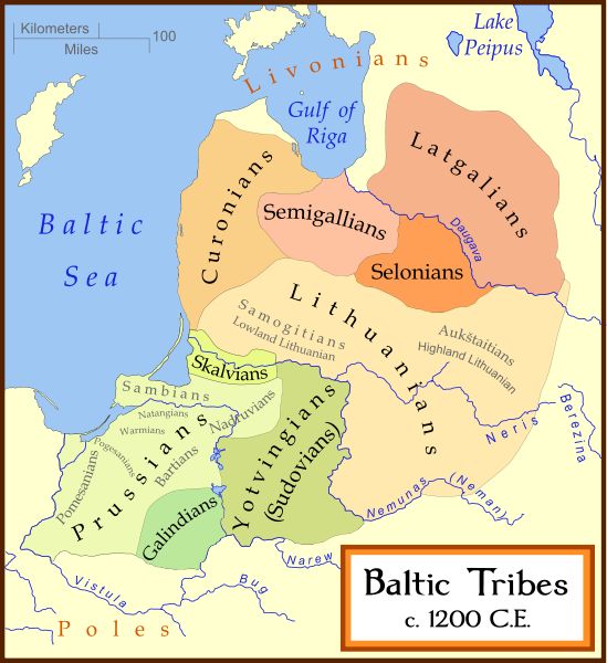
c. 1200 Baltic tribes.
From www.latviahistory.
wordpress.co
From www.latviahistory.
wordpress.co
1200 "LIETUVIU GIMINES SENOVEJE."
(Ancient lands of Lithuania)
(Ancient lands of Lithuania)

Ona Maksimaitienė: "Baltai XIII
a. Pradžioje" (Baltic peoples at the
beginning of the 13th century),
from her "Lietuvos Istorinės
Geografijos Bruožai." (AK)
a. Pradžioje" (Baltic peoples at the
beginning of the 13th century),
from her "Lietuvos Istorinės
Geografijos Bruožai." (AK)

860 - 1139 Maria Regina Korzeniowska:
"POLSKA nabytki od roku 860 - 1333"
(Poland acquisitions in...), from her 1831
"Atlas historyczny, genealogiczny, chrono-
logiczny i geograficzny Polski." Since the
"Polish state" began no earlier than 962,
there was no "Poland" to acquire territory
for the first 102 years of Korzeniowska's
map. From http://rcin.org.pl/dlibra


1139 - 1333 Maria Regina
Korzeniowska: "POLSKA
strati od roku 1139 -
1333" (Poland's losses in
the years...), from her
1831 "Atlas historyczny,
genealogiczny,
chronologiczny i
geograficzny Polski." From
http://rcin.org.pl/dlibra
Korzeniowska: "POLSKA
strati od roku 1139 -
1333" (Poland's losses in
the years...), from her
1831 "Atlas historyczny,
genealogiczny,
chronologiczny i
geograficzny Polski." From
http://rcin.org.pl/dlibra


1025 Eligiusz Niewiadomski: "Polska za Bolesława
Chrobrego r. 1025" (Poland at the time of Bolesław
the Brave, year 1025), in versions from the 1908
(left) and second, 1920 (right), editions of "Atlas do
Dziejów Polski zawierający," with maps after
Joachim Lelewel. Changes from 1908 to 1920: 1.
"Litwa" -- implying a country, became "Litwini," a
tribe; 2. a river identified both by its Lithuanian
name, "Neris," and its Polish name, "Vilja," loses the
Lithuanian name. In both maps, the Lithuanian
river Nemunas goes only by its Belarusian/Polish
name: "Nieman." From www.mapywig.org
1025 J.M. Bazewicz: "Polska za
Bolesława Chrobrego Rok 1025"
(Poland in the time of Bolesław
the Brave, 1025), from his 1918
"Atlas historyczny Polski,
wydanie II." Note "Wilia"" and
"Litwini." From www.mapywig.org
Bolesława Chrobrego Rok 1025"
(Poland in the time of Bolesław
the Brave, 1025), from his 1918
"Atlas historyczny Polski,
wydanie II." Note "Wilia"" and
"Litwini." From www.mapywig.org
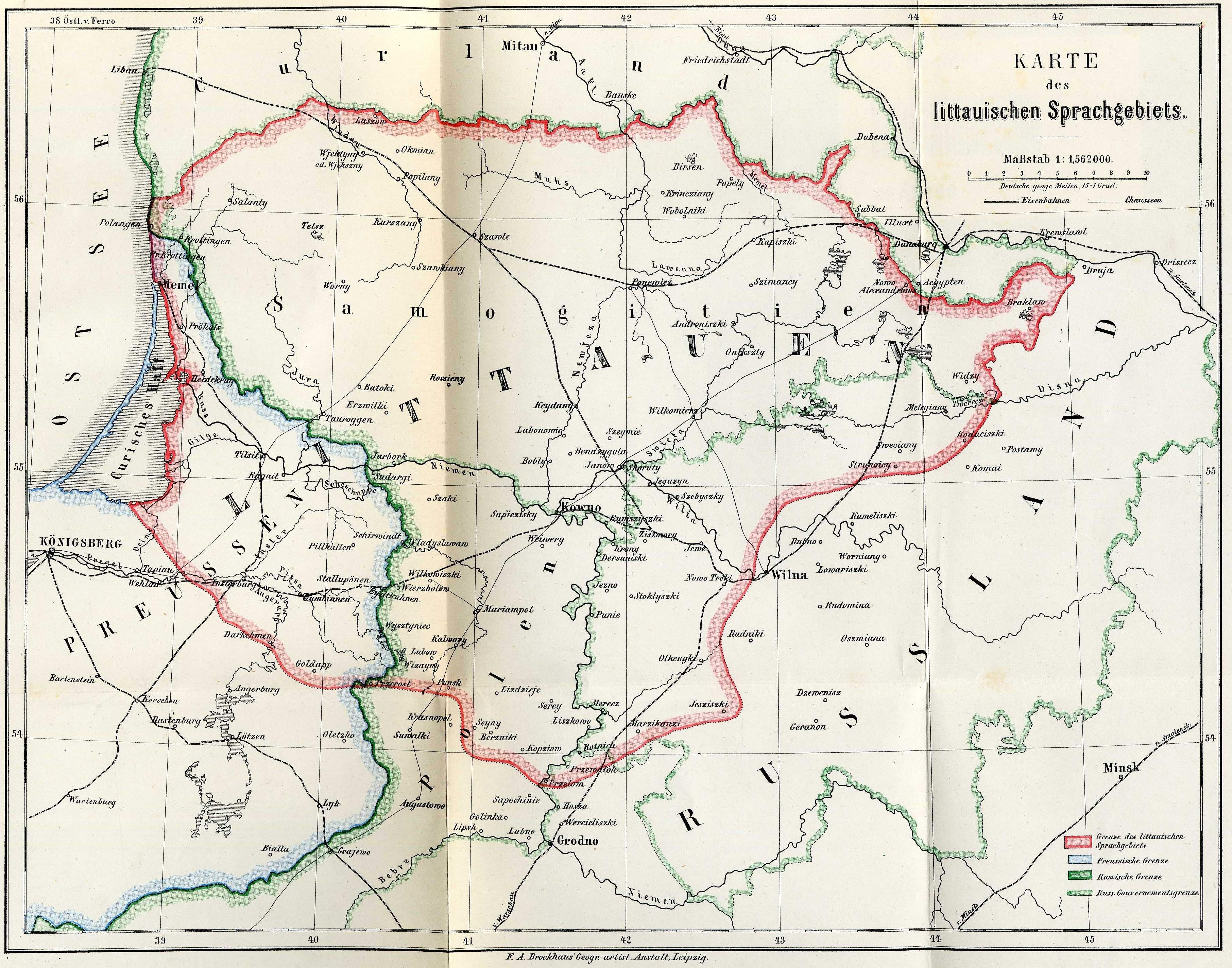
1876 "KARTE des
littauischen Spracht-
gebiets" (showing where
Lithuanian was spoken).
From Dr. Friedrich
Kurchat's "Grammatik
der littauschen
Sprache," Konigsberg.
littauischen Spracht-
gebiets" (showing where
Lithuanian was spoken).
From Dr. Friedrich
Kurchat's "Grammatik
der littauschen
Sprache," Konigsberg.


1279 Eligiusz Niewiadomski: "Polska w podziałach r.
1279. - Bolesław Wstydliwy książę krakowski. -
Litwa epoki Wojsiełka" (Poland in the time of divisions
- Bolesław Wstydliwy prince of Kraków - Lithuania in
the epoch of Vaišelga/Vaišvilkas), in versions from
the 1908 (left) and second, 1920 (right), editions of
"Atlas do Dziejów Polski zawierający." Maps after
Joachim Lelewel. In both maps, the area ascribed to
Lithuania(ns) is denoted as "Dzielnice wielkopolskie"
(Districts of Greater Poland). Changes from 1908 to
1920: "Wilno" is absent from the "Litwa" area in the
1908 version, only to appear in the 1920 version.
From www.mapywig.org

Nichoas Sanson: "Germano-sarmatia; Kartenmaterial; in qua populi maiores Venedi, et Æstiæi; Peucini, et
Bastarnæ in minores populos divisi ad hodiernam locorum..." dated and published 1655 by Pierre Mariette in Paris,
15.2 x 21.9 inches / 38.7 x 55.5 cm, in four versions engraved by J.Somer.
Bastarnæ in minores populos divisi ad hodiernam locorum..." dated and published 1655 by Pierre Mariette in Paris,
15.2 x 21.9 inches / 38.7 x 55.5 cm, in four versions engraved by J.Somer.


1333 Eligiusz Niewiadomski: "Polska za
Władysława Łokietka r. 1333. Dzierżawy litewskie
Gedymina" (Poland at the time of Władysław the
Elbow-high - Lithuanian hereditary lands of
Gediminas), from the 1908 (left) and 1920 (right)
editions of his "Atlas do Dziejów Polski
zawierający..." (Atlas of Polish history...). In the
1908 version, Kiev (Kijow) is clearly part of
Lithuania; in the 1920 version, Lithuania's
southeastern borders are left blank, with Kiev not
part of the Grand Duchy. The reality: Although
ruled by a Lithuanian prince in 1333, Kiev had to
pay tribute to the Golden Horde. Only after the
Battle of Blue Waters in 1362, were Kiev and
surrounding areas incorporated into the Grand
Duchy by Grand Duke Algirdas. Both versions
allow Lithuania specific territory. From www.
mapywig.org
1333 Józef Michał Bazewicz:
"Polska za Wład. Łokietka Rok
1333," from his 1918 "Atlas
historyczny Polski, wydanie II."
Of the 3 mapmakers of 1333, he
is the only one to assign to Lith-
uania the name "Wielkie Księstwo
Litewskie," but fails to show its
eastern boundaries. From www.
mapywig.org
"Polska za Wład. Łokietka Rok
1333," from his 1918 "Atlas
historyczny Polski, wydanie II."
Of the 3 mapmakers of 1333, he
is the only one to assign to Lith-
uania the name "Wielkie Księstwo
Litewskie," but fails to show its
eastern boundaries. From www.
mapywig.org


Charles Francois Delamarche: "Germano-
Sarmatia; Kartenmaterial; ex mente
Ptolomæi et N. Sanson descripta, nec non im
majores minores que populos distincta..."
(German0-Sarmatia; Map inspired by
descriptions from Ptolemy and N. Sanson, not
ignoring smaller tribes which are a distinct
people), published 1790 in Paris. From the
Universität Bern, Switzerland via the
EuropeanLibrary.org

Pierre Mortier, after
Sanson: "Germano-Sar-
matia in qua Populi
maiores Venedi et Aetiaei
Peucini et Bastarnae in
minores Populos divisi ad
hodiernam locorum..,"
Amsterdam, 22 x 16
inches, published c1710.
From www.raremaps.com
Sanson: "Germano-Sar-
matia in qua Populi
maiores Venedi et Aetiaei
Peucini et Bastarnae in
minores Populos divisi ad
hodiernam locorum..,"
Amsterdam, 22 x 16
inches, published c1710.
From www.raremaps.com
1837 Constant Desjardins: "Ethnographische Karte von Europa,
oder Darstellung der Haupt-vertheilung der europaischer
Volker nach ihren Sprachen und Religions- Verschied- enheiten"
(Ethnographic map of Europe, or representation of the primary
distribution of European Peoples according to their languages and
religious differences), Wien (Vienna), 62 x 50 cm, from
"Physisch- statistisch und politischer Atlas von Europa..." From
the explanatory text, displayed as one of two DETAIL images:
"IV. SLAVISCHE FAMILIE...7) Lithauer zwischen Niemen and
Dnieper etc. 8) Letten in Kurland und Liefland, so wie in einem
Theile von Ost-Preussen. (...as in a part of East Prussia)!..V. DIE
FINNISCHE...FAMILIE...B 2) Esthen im Gouvernment Esthland
mit den Liven in Liefland." From www.davidrumsey.com


1837 Two maps by Jan Marcin Bansemer and Piotr Falkenhagen-Zaleski: on the left,
"POLAND and the Neighboring Countries according to the Languages of the Inhabitants;" on
the right, "POLAND and the Neighboring Countries according to the Religion of the
Majority." Both are from the James Wyld London-published "Atlas Containing Ten Maps of
Poland Exhibiting the Political Changes That Country Has Experienced During the Last
Sixty Years, From 1772 to the Present Time...Compiled from the Works of Malte-Brun,
Stanislas Plater, Lelewel, Swienicki, Ruhiere, Ferrand, Balbi, Schnitzler, Hassel, L. Chodzko
and Other Eminent Writers." Note, on the "religions" map: "Polish Liefland" is "Roman
Catholic," as is today's Belarus almost to Minsk; on the "languages" map: "Lithuanian" is
shown as the majority language as far east as "Smorgonie," and as far south as Lida and
Grodno. From www.eurotopo.org
1929 Inst. Kartograficzny Warszawa: on the left: "Mapa rozsiedlenia ludności Litewskiej na
terenie Republiki Litewskiej" (Map of distribution of Lithuanian population in the area of the
Republic of Lithuania) a map showing percentage of Lithuanians in Lithuania); on the right:
"Mapa rozsiedlenia ludności polskiej na terenie Republiki Litewskiej i na obszarach północnych
Rzeczypospolitej Polskiej nazwa współczesna" (Map of distribution of Polish population in the area
of the Republic of Lithuania and in northern areas of the Republic of Poland), Warszawa, at 1:750
000. I looked at the statistics on both maps for my ancestral town: Žiežmariai ("Žyžmory" on
the map). Poles are said to comprise 10% - 20% of the population; Lithuanians 50% - 75%. So,
according to these Polish-produced maps, Lithuanians and Poles supposedly accounted for
60% - 95% of the population. Reality check: the 1923 Lithuanian census -- the only census in
Inter-war Lithuania -- counted 2,198 residents, of whom 1,205 (55%) were Jews: a not
uncommon percentage for towns in those days. Ethnicity was determined by primary
language spoken -- following the precedent of the 1897 Russian census. The Lithuanian
census determined that the population was 84% Lithuanian-speakers, 7.6% Yiddish-speakers,
3.2% Polish-speakers, 2.5% Russian/ Belarussian-speakers, and 0.7% Latvian-speakers. The
Polish Election Committee disputed those findings, saying Poles comprised 10% of the
population and Lithuanians 76.4%. The basis for their claim was the 202,000 votes
(representing about 9.5%-10% of population) cast for Polish political candidates in the 1923
Lithuanian elections. All-in-all, pretty weak justification on both sides for territorial
boundary and political decisions made on the basis of "ethnicity." First map from www.mapywig.org


1930 "Poland and the Baltic" postcard map,
which appears to have been based on the
ethnographic map to the left. AK collection,
donated to PJ Mode and his collection, displayed
online at:
https://persuasivemaps.library.cornell.edu/
which appears to have been based on the
ethnographic map to the left. AK collection,
donated to PJ Mode and his collection, displayed
online at:
https://persuasivemaps.library.cornell.edu/


1841 Gottfried Hensel: "Europa poly
glotta: Ling- uarum genealogiam exhib-
ens, una cum literis, scriben- diq[ue]
modis, omnium gen- tium,”
Nuremberg, 16 x 21 cm., from his
"Synopsis vniversae philologiae." The
earliest linguistic map of Europe. From
princeton.edu
glotta: Ling- uarum genealogiam exhib-
ens, una cum literis, scriben- diq[ue]
modis, omnium gen- tium,”
Nuremberg, 16 x 21 cm., from his
"Synopsis vniversae philologiae." The
earliest linguistic map of Europe. From
princeton.edu

1846 Gustaf Kombst.
“Ethnographic Map of
Europe,” Edinburgh,
46.9 × 56.8 cm., from
Alexander Keith Johnston’
s The National Atlas of
Historical, Commercial,
and Political Geography."
From princeton.edu
“Ethnographic Map of
Europe,” Edinburgh,
46.9 × 56.8 cm., from
Alexander Keith Johnston’
s The National Atlas of
Historical, Commercial,
and Political Geography."
From princeton.edu

1772: "Territoire politique
et ethn graphique de la Po-
logne (1772)," from "Atlas
problémes territoriaux
Pologne," Lviv, Warsaw,
1921. No mention of
Lithuania. From
www.rcin.org.pl/dlibra
et ethn graphique de la Po-
logne (1772)," from "Atlas
problémes territoriaux
Pologne," Lviv, Warsaw,
1921. No mention of
Lithuania. From
www.rcin.org.pl/dlibra


| 1849 |
Heinrich Berghaus: 1847: "Übersicht von Europa; mit
ethnograph." 1849: "Ethnograph- ische Karte von
Europa, Auf F.v. Stulpnagel's geogr." Both published by
Justus Perthes, Gotha, from editions of his
"Physikalischer Atlas oder Sammlung von Karten, auf
denen die hauptsachlichsten Erscheinungen der
anorganischen und organischen Natur nach ihrer
geographischen Verbreitung und Vertheilung bildlich
dargestellt sind..." A.K. Johnston's "Physical Atlas" of
1848 was based on the 1847 edition. In the 1847
version, we see only "Letten." In the 1849 versions, we
see both "Letten" and "Littauer." From
www.davidrumsey.com

1856 Louis Dussieux: "Carte Ethnograph-
ique de L'Europe," Paris, 31 x 40 cm, dated
1848, but published in his 1856 "Atlas
General De Geographie Physique, Politique
Et Historique." See "Lithuaniens" under
"Race Lettone." From www.davidrumsey.com
ique de L'Europe," Paris, 31 x 40 cm, dated
1848, but published in his 1856 "Atlas
General De Geographie Physique, Politique
Et Historique." See "Lithuaniens" under
"Race Lettone." From www.davidrumsey.com
1861 James Cowles Pritchard: "Ethno-
graphic Map of Europe in the Earliest
Times, Illustrative of Dr. Pritchard's
Natural History of Man and His
Researches into the Physical History of
Mankind," London, 49 x 62 cm. From
www.davidrumsey.com
graphic Map of Europe in the Earliest
Times, Illustrative of Dr. Pritchard's
Natural History of Man and His
Researches into the Physical History of
Mankind," London, 49 x 62 cm. From
www.davidrumsey.com

1868 Casimir Delamarre: "Carte Linguis-
tique, Ethnographique, et Politique
actuelle de l'Europe orientale," Paris, 47 x
30 cm. In early 1869 he introduced a
petition in the Ukrainian case to the French
Senate, which was issued in the same year
under the title "The Fifteen Million
European People Forgotten in History."
Note the area of "Langue Lithuanienne"
and its reach north, and east past "Wilna."
From Baitsar.blogspot.com

c. 1900 Paul R. Magocsi:
with Geoffrey J. "Poland
in the 20th Century:
Major concentrations of
Poles, c1900," from their
1993 "Historical Atlas
of East CentralEurope."
Note lack of Poles in what
would become "Central
Lithuania" after WWI.
From www.libraryexhibits.
utad.utoledo.edu/mppcoll/
history/g2081magocsi.html
with Geoffrey J. "Poland
in the 20th Century:
Major concentrations of
Poles, c1900," from their
1993 "Historical Atlas
of East CentralEurope."
Note lack of Poles in what
would become "Central
Lithuania" after WWI.
From www.libraryexhibits.
utad.utoledo.edu/mppcoll/
history/g2081magocsi.html


c. 500 "Languages in
Europe." Compare with
the c850 map below. From
www.info-poland.buffalo.edu
Europe." Compare with
the c850 map below. From
www.info-poland.buffalo.edu
c. 850 "Languages in Europe." Combines
Baltic with Illyrian, which was separated
from Baltic in the C500 map above. "Baltic-
Illyrian" is in future Albania and future
Lithuania-Latvia, and pockets in future
Belarus and Russia, reflecting the "Pan-
Illyrian" theory of Hans Krahe, who pro-
posed an "Illyrian" tongue predating Indo-
European. From www. info-poland.buffalo.edu
1872 Heinrich Kiepert (historian/linguist
/cartographer): "Völker und Sprachen-
Karte von Deutschland und den Nachbar-
ländern" (Peoples and Languages in
Germany and Neighboring Lands), Berlin,
42 x 54 cm, at 1:3 000 000, published by
Dietrich Reimer. Note that "Littauer"
predominate in the post-WWII-boundary
for Lithuania, except south and west of
"Merecz" (Merkinė) and east of "Wilna."
From the Library of the University of Chicago:
https://luna.lib.uchicago.edu

1881 Richard Andree: "Die verbreitung
der Juden in Mitteleuropa" (The distribu-
tion of the Jews in Central Europe), color-
coded by percentage ranges, showing
"Estland" at less than 0 .1%; "Livland" at
0.5 - 1%; "Kurland" at 4 - 9%; "Witebsk,"
"Kowno," "Wilna" and "Minsk" at 9 - 13%;
"Suwalki," "Grodno" and "Mohilev" at 13 -
18%. From wikicommons

1892 F.A. Brockhaus: "ETHNOGRAPHI-
SCHE KARTE VON EUROPA," Leipzig, from
the 14th edition of "Broackhaus' Konversa-
tions-Lexicon," published 1892-95. Letten-
Litauer" have "Ost-Slaven" ("Gross-, Weiss-,
and Klein- Russen" to the east, and
surrounding "Wilna," with pockets of
"Deutscher" in "Memel," "Kowno," "Libau"
and "Mitau" From beromausers

1895 Richard Andree:
"ETHNOGRAPHIC MAP of
EUROPE," London, 24 x 37
cm, from The Times Atlas,
published by The Times. A
differently-colored version
of the preceding Brockhaus
map.minus the pockets of
Germans in future Lithu-
ania and Latvia. From
www.davidrumsey.com
"ETHNOGRAPHIC MAP of
EUROPE," London, 24 x 37
cm, from The Times Atlas,
published by The Times. A
differently-colored version
of the preceding Brockhaus
map.minus the pockets of
Germans in future Lithu-
ania and Latvia. From
www.davidrumsey.com
862 Leonard Chodźko: "SLAVO-POLO NAISE
aux VIII et IV Siecles...Rurik 862..." from
his 1861 "Histoire de la Lithuanie et de la
Ruthénie," maps after Joachim Lelewel.
Chodźko has Balts descended from the
Heruli, a Germanic tribe who, with the
Goths, sacked Rome in 267. From the British
Library, via Wikimedia.
aux VIII et IV Siecles...Rurik 862..." from
his 1861 "Histoire de la Lithuanie et de la
Ruthénie," maps after Joachim Lelewel.
Chodźko has Balts descended from the
Heruli, a Germanic tribe who, with the
Goths, sacked Rome in 267. From the British
Library, via Wikimedia.

"Baltų Gentys IX - XII a."
(Baltic Tribes 801 - 1200).
Vilnius. From Pradai"s
"Mokyklinis Lietuvos Istorijos
Atlasas." (AK)
(Baltic Tribes 801 - 1200).
Vilnius. From Pradai"s
"Mokyklinis Lietuvos Istorijos
Atlasas." (AK)


1898 "RUSSIE - Races
et Religions" of the
European part of the
Russian Empire,
Paris. From "Histoire
Et Géographie - Atlas
Général Vidal-
Lablache," Librairie
Armand Colin. From
www.karty.by
et Religions" of the
European part of the
Russian Empire,
Paris. From "Histoire
Et Géographie - Atlas
Général Vidal-
Lablache," Librairie
Armand Colin. From
www.karty.by

1900 "Ethnographic map of Europe,"
London, 24 x 37 cm., at 1:20 000 000,
from "The Times Atlas." This is the English
version of the German Andrees Handatlas,
3rd edition: 1893-1897. "Lithuanians"
occupy an area roughly equivalent to
post- WWI Lithuania, with "White
Russians to the east and south. From
www.davidrumsey.com
London, 24 x 37 cm., at 1:20 000 000,
from "The Times Atlas." This is the English
version of the German Andrees Handatlas,
3rd edition: 1893-1897. "Lithuanians"
occupy an area roughly equivalent to
post- WWI Lithuania, with "White
Russians to the east and south. From
www.davidrumsey.com

1918 Juozas Gabrys: "La
Carte Ethnographique
de L'Europe," Berne,
published by Librairie
Centrale des National-
ites, with "Lithuaniens"
going south of "Gardi-
nas" (Grodno) and far
east of Vilnius. Also,
"Letgalians" get their
own area: former
Polish-Lithuanian
Livonia. From wikimedia.
Carte Ethnographique
de L'Europe," Berne,
published by Librairie
Centrale des National-
ites, with "Lithuaniens"
going south of "Gardi-
nas" (Grodno) and far
east of Vilnius. Also,
"Letgalians" get their
own area: former
Polish-Lithuanian
Livonia. From wikimedia.


1915 (Anon.): "Mapa rozsiedlenia ludności polskiej w
granicach etno- graficznych i na najbliższych kresach"
(Distribution map of the Polish population by its ethno-
graphic boundaries), Warsaw, 83 x 97 cm, at 1:1 000
000. Published by the Polish Union of Progressive s, and
supposedly showing concentrations of "ethnic Poles."
Three years earlier, on Orgelbrand's map, the per-
centage of Poles in a broad area around Vilnius was 6% to
12%, with Vilnius center as high as 30%. In the 1915
map, the percentage leaps to 50% to 100% in the same
areas. There were no censuses in the meantime, only
guesstimates by "Progressive" Poles eager to claim the
Vilnius area as their own. From http://rcin.org.pl/dlibra

1919 Albert H. Bumstead : "Map of the
Races of Europe," published by the Carto-
graphy Department, under the direction
of Edwin and Gilbert Grosvenor, of The
National Geographic Magazine. Under the
heading "Balto-Slavs" we find "Lithuanians
/Letts" (overlapped to the east and south
by "Great-" and "White-Russians ," but not
by "Poles"), as well as "Armenians." From
skyscraper city.com
1861 A. Koreva:
"Этнографическая карта,
ВИЛЕНСОЙ ГУБЕРНIИ"
(Ethnographic Map, Vilna
guberniya), St. Petersburg.
Slavs (future Belarusians) are
three shades of pink:
"Белорусы" (White Russian --
originally, those from eastern
Muscovy, Polotsk and
Novgorod): pink horizontal
lines;, "Кривичи" (originally, an
eastern Slavic tribe, centered in
Polotsk); "Чернорусы" (Black
Russians -- originally, those
from Pskov and western
Muscovy). The two other
ethnic groups are Lithuanians,
in yellow, who occupy all the
area around "Vilno," and
Tatars, in a few pockets within
the Lithuanian area. From
Bayerischen Staatsbibliothek
München.


c1916-17 L. Dury: "Mapa rozsiedlenia
ludności polskiej z uwzględnieniem spisów z
1916 roku. Odsetek ludności polskiej w
powiatach" (Map of percent of Polish
nationals, according to the [March] 1916
German occupation census), Warsaw: solid
red = 50% +; horizontal red lines: 31-50%;
cross-hatch: 20-30%; diagonal lines: 5-19%.
Interesting, except the German census did
not include eastern Belarus or Latgale,
where this maps says Poles supposedly
comprise 5-19%. As believable as 25% Poles
in "Kowno" and parts north. From wikimedia

1914 Czesław Jankowski
(Polish poet/critic/ journal-
ist /historian/social activist):
"POLSKA ETNOGRAFIC-
ZNA," Warsaw, with
boundaries basically
following Orgelbrand's
from 1912, with no inclu-
sion of present-day Lithu-
anian or Belarusian land.
From http://polona.
pl/item/11152767/10/
(Polish poet/critic/ journal-
ist /historian/social activist):
"POLSKA ETNOGRAFIC-
ZNA," Warsaw, with
boundaries basically
following Orgelbrand's
from 1912, with no inclu-
sion of present-day Lithu-
anian or Belarusian land.
From http://polona.
pl/item/11152767/10/

16th Century Zigmas
Zinkevičius: "Area of
the Lithuanian
Language," from his
"Lietuvių tautos
kilmė," 2005, p.230.
From wikipedia
Zinkevičius: "Area of
the Lithuanian
Language," from his
"Lietuvių tautos
kilmė," 2005, p.230.
From wikipedia

1923 "Hammond's Racial Map of Europe,"
showing Lithuanians surrounded on the
east and in the Vilnius area by White
Russians, with Poles only south and west of
Suvalkai. From "Source Records of the Great
War," National Alumni, 1923, via wikimedia
showing Lithuanians surrounded on the
east and in the Vilnius area by White
Russians, with Poles only south and west of
Suvalkai. From "Source Records of the Great
War," National Alumni, 1923, via wikimedia

1815 "Languages, peoples
and political divisions of
Europe, 1815 - 1914." This
maps shows only "White
Russians" to the east and
south of Lithuanians, with
Poles only touching south of
the Suvalkai region. From
www.buffalo.edu
and political divisions of
Europe, 1815 - 1914." This
maps shows only "White
Russians" to the east and
south of Lithuanians, with
Poles only touching south of
the Suvalkai region. From
www.buffalo.edu
1942 Jekab Jureviz, Gottfried Müller, Hermann Warren: "Ostland-Atlas: Baltische Randstaaten,"
Riga, published by Reichskommissar für das Ostland. One of two reports that make up the
"Strukturbericht über das Ostland" (Structural Report on the Ostland), the other being "Ostland in
Zahlen" (Ostland in Numbers). This report was created by the Nazi Reich Commissioner for the Eastern
Territories and used in the civil administration of the occupied Eastern Territories: Estonia, Latvia,
Lithuania, Belarussia and part of Poland. The 52 color maps show the occupied administrative
territories, their climate and vegetation, population demographics, agricultural status, industry,
energy and economic features, traffic and roads, foreign trade in 1938, and the history of the area to
1943. Ethnographic and religion maps are shown below. (Others are at the "Maps1940-45" page).
From Ball State University's digital library, at www.bsu.edu
| "Bevölkerung nach der Volkszugehöringkeit i.v.H." Percentage of the Population by Ethnicity |
| "Bevölkerung nach der Religionszugehörigkeit i.v.H." depicting only three Christian religions: Roman Catholic, Protestant and Orthodox |

1908-16 "Polacy i
Litwini," from the "Polski
Atlas Kongresowy" of
1921, showing percentage
of Poles and Lithuanians
in Poland and Lithuania.
From http://rcin.org.pl/dlibra
Litwini," from the "Polski
Atlas Kongresowy" of
1921, showing percentage
of Poles and Lithuanians
in Poland and Lithuania.
From http://rcin.org.pl/dlibra


1919 "Ligne de démarca-
tion Polono- Lithu anienne"
(Demarcation Lines
between Poland and
Lithuania in 1919), along
with areas of majorities of
Poles and Lithuanians,
published 1921 in "Polski
Atlas Kongresowy." From
http://rcin.org.pl/dlibra
tion Polono- Lithu anienne"
(Demarcation Lines
between Poland and
Lithuania in 1919), along
with areas of majorities of
Poles and Lithuanians,
published 1921 in "Polski
Atlas Kongresowy." From
http://rcin.org.pl/dlibra
1921 "Carte Etnographique du Comite
National Polonais" (Ethnographic map by the
Polish National Committee) published 1921 in
"Polski Atlas Kongresowy." Shows, among
other things, that eastern Courland,
including the area just south of Daugavpils,
was over 50% Polish. From http://rcin.org.pl/dlibra
National Polonais" (Ethnographic map by the
Polish National Committee) published 1921 in
"Polski Atlas Kongresowy." Shows, among
other things, that eastern Courland,
including the area just south of Daugavpils,
was over 50% Polish. From http://rcin.org.pl/dlibra

1910 "Les Juifs en Pologne
1910," from the 1921
"Polski Atlas Kongresowy,"
showing percentage of
Jews within the
boundaries of the
pre-Partition Polish-
Lithuanian Common-
wealth. From
http://rcin.org.pl/dlibra
1910," from the 1921
"Polski Atlas Kongresowy,"
showing percentage of
Jews within the
boundaries of the
pre-Partition Polish-
Lithuanian Common-
wealth. From
http://rcin.org.pl/dlibra

1921 "Gęstość Polaków" (Density of Poles)
from "Polski Atlas Kongresowy - Atlas des
Problemes Territoriaux de la Pologne,"
published 1921 in Lwów and Warszawa.A
little from the map to the left from the
same atlas, no? From http://rcin.org.pl/dlibra
from "Polski Atlas Kongresowy - Atlas des
Problemes Territoriaux de la Pologne,"
published 1921 in Lwów and Warszawa.A
little from the map to the left from the
same atlas, no? From http://rcin.org.pl/dlibra
1921 Eugeniusz Romer: "Polish territory
with over 50% of Poles according to the
materials and documents of the last years
1914 - 1920," Lwów, from "Geograficzno-
Statystyczny Atlas Polski." Yet another
view, one that shows concentrations not
only unlike those shown on the previous
map, but unlike most others, and yet with
great specificity. From wikimedia


June 1923 Foreign Affairs Magazine:
"Ethography of the Vilna Region,"
showing competing claims and
political resolution.
"Ethography of the Vilna Region,"
showing competing claims and
political resolution.
| Dated 1655 www.polona.pl via wikimedia |
| Dated 1655 Univ of berne, Switzerland, via http://www.europeana.eu |
| Dated 1703 www.panorama-antyki.pl |


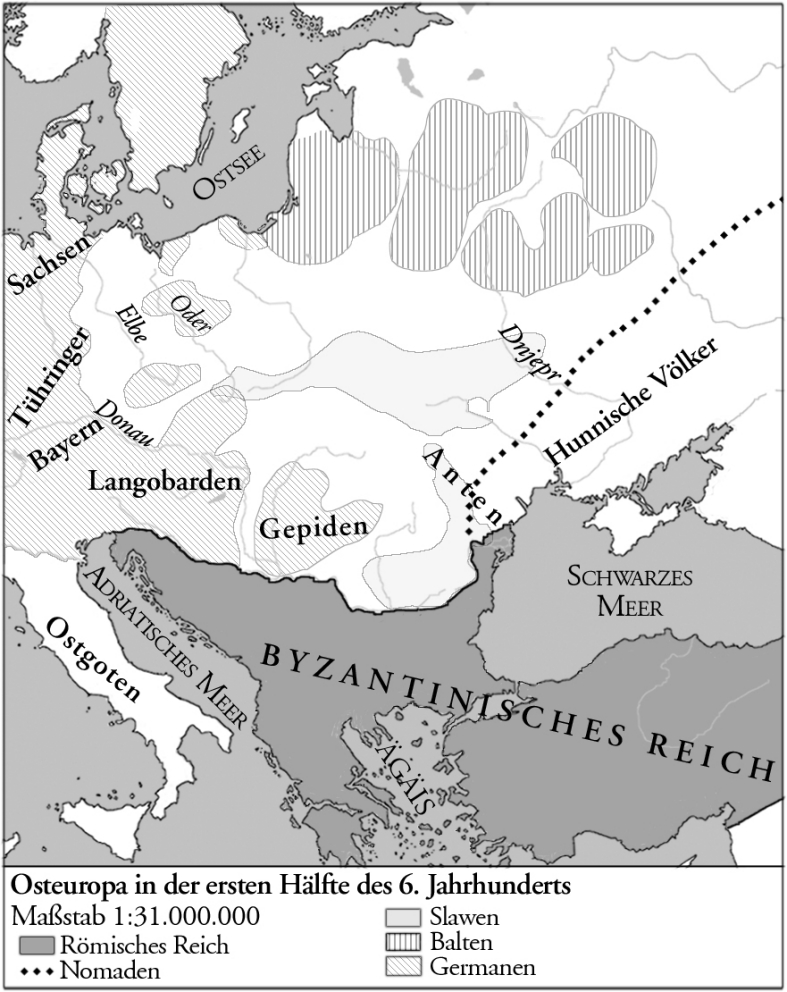
501 - 550 (Anon.):
"Osteuropa in der
ersten Hälfte des 6
jahrhunderts."
From Univ. at Klagen-
furt: http://eeo.uni-klu.
ac.at/
"Osteuropa in der
ersten Hälfte des 6
jahrhunderts."
From Univ. at Klagen-
furt: http://eeo.uni-klu.
ac.at/

1921 Marian Świechowski: "Le problème
Lithuanien," booklet cover, commentary
and two maps by a member of Poland's
Parliament, and the editor of the interwar
"Glocu Wilna" (Voice of Vilnius) that offer
two solutions to the "Lithuania problem": be
absorbed by Germany/East Prussia, or by
Poland. From www.mapywig.org
Lithuanien," booklet cover, commentary
and two maps by a member of Poland's
Parliament, and the editor of the interwar
"Glocu Wilna" (Voice of Vilnius) that offer
two solutions to the "Lithuania problem": be
absorbed by Germany/East Prussia, or by
Poland. From www.mapywig.org

1919 Vladas Daumantas (Dzimidavičius) (mapmaker/politician):
"Carte de la Lituanie," Lausanne, and the English translation:
"LITHUANIA," published in the USA, each with five inset maps
showing historic boundaries, and a key denoting 13 levels of
Lithuanian ethnicity! A rejoinder to Polish-produced ethnic maps
distributed to Versailles Peace Treaty dliberators.

1917-18 Eugeniusz
Romer: "Just think!
There are 30 Million
Poles!," postcard printed
in Lausanne by the
Polish National
Committee, no doubt
prepared for the delib-
erations in Versailles on
the post-WWI boundaries
of Poland and Lithuania.
Boundaries for the
"Ancient Polish Republic,
Dismembered 1772 -
1795 are shown. "Plainly
propaganda" according to
Steven Seegel's "Mapping
Europe's Borderlands"

1911 V. Verbickas (archaeologist/
engineer/publisher): "Lietuvos žemelapis su
etnografijos siena" (Map of Lithuania with
ethnographic borders), published in St.
Petersburg by the Il'in firm, and in Kaunas
by the company "Lietuvos ūkininko"
(Lithuanian Farmer). From The Wroblewski
Library of the Lithuanian Academy of Sciences:
elibrary.mab.lt/

1856 Alexander Keith Johnston: "Ethno-
graphic map of Europe according to Dr.
Gustaf Kombst..," Edinburgh, 51 x 62 cm.
from the second edition of Johnston's "The
physical atlas of natural phenomena." The
map is little changed from the 1846
version above: "Lettons," but not
"Lithuanians," are a recognized ethnicity.
From www.davidrumsey.com

| Dated 1703 www.davidrumsey.com |


| 1919 "Carte de Lituaniie" |
The same map, one in French, one in German, with boundaries of Lithuanian
Ethnographic territory the same in each, and to Lithuania's advantage, but with
the French, earlier, version showing the "Boundary of the new State of Lithuania,"
while the later German-language version has the same boundary labeled "The
Presumptive Boundary of the new State of Lithuania." From The Wroblewski Library of
the Lithuanian Academy of Sciences: elibrary.mab.lt/

9th Century "Carte Ethnographique -
Des Pays Slaves" (Ethnographic Map -
Slavic Countries), Paris, from “La Pologne
et ses frontieres”...translated by E.
Johnstone." From the British Library, via
europeana.eu
Des Pays Slaves" (Ethnographic Map -
Slavic Countries), Paris, from “La Pologne
et ses frontieres”...translated by E.
Johnstone." From the British Library, via
europeana.eu

1303 - 1795 Dr. John
P.Stankievich: "Ethno-
graphical and Historical
Territories and Boun- daries
of Whiteruthenia (Kryvia,
Byelorussia)," New York,
1953. Note from
pravapis.org: a rare
ethnographic map from the
well-known 20th century
Belarusan lin- guist and
ethnography
researcher. From www.
pravapis.org/art_belarus_
ethnographic_ map1953.asp


1875 Aleksandr Fyodorovich Rittikh / Alexander
Rittich (Александр Фёдорович Риттих): "Этно-
графическая карта Европейской России" (Ethno-
graphic Map of European Russia), St Petersburg.
Based on both language and "confession" - religion.
DETAIL images include the legend, which includes
colors under Литовская (Lithuaniaт g.) for Литва
(Lithuania) and Латыши (Latvia). From wikimedia
1875 Aleksandr Fyodorovich Rittikh /
Alexander Rittich (Александр Фёдорович
Риттих): "ЭАПАДНЫХЪ ЮЖНЫХЪ
СЛАВЯНЪ" (Western and Southern Slavs). St
Petersurg. Also a DETAIL image of the
legend, data based on both language and
"confession" - religion, which includes colors
under Литовская (Lithuaniaт g.) for Литва
(Lithuania) and Латыши (Latvia). From www.
lujicajazz.narod.ru


1919 J. Franckevičius
(publisher): "Žemlapis
Žemaičių vyskupijos su
etnografiniu lietuviu
plotu" (Map of the
Samogitian Diocese with
Lithuanian ethnographic
areas). From The Wroblewski
Library of the Lithuanian
Academy of Sciences: elibrary.
mab.lt/
(publisher): "Žemlapis
Žemaičių vyskupijos su
etnografiniu lietuviu
plotu" (Map of the
Samogitian Diocese with
Lithuanian ethnographic
areas). From The Wroblewski
Library of the Lithuanian
Academy of Sciences: elibrary.
mab.lt/

1939 (Anon.): "POLACY," showing areas in
Poland, Lithuania and East Prussia where
Poles comprised more than 50% and less
than 50% of the population. Also two
charts, one showing percentage of popu-
lation of all ethnicities in Poland, and
number of Poles in a number of countries
in the world. From www.karty.by
Poland, Lithuania and East Prussia where
Poles comprised more than 50% and less
than 50% of the population. Also two
charts, one showing percentage of popu-
lation of all ethnicities in Poland, and
number of Poles in a number of countries
in the world. From www.karty.by

c. 1930 J. Rozwadowski:
"Mapa języka litewskiego
(Map where Lithuanian is
spoken)," Kraków, on a
map showing pre-WWI
guberniyas,
distinguishing between
"Zwarty obszar jezyka
litewskiego" and
"Mieszany obszar jezyka
litewskiego" (Dense and
Mixed Lithuanian
Language areas). From The
Wroblewski Library of the
Lithuanian Academy of
Sciences: elibrary.mab.lt/


c. 1935 Julius Iwan Kettler (geographer/
cartographer)- Carl Flemming (publisher):
"Völkerkarte von Nord- polen und Ostdeutsch-
land," (Ethnic Map of North Poland and East
Germany [and Lithuania]), Berlin/ Glogau, . 24
x 15 cm. From the Digital Library of the University of
Wroclaw: www.bibliotekacyfrowa.pl/dlibra,
via www.easteurotopo.orgwww.bibliote


1906 David Aïtoff (mapmaker): "Carte
Ethnographique de la Russie d' Europe, dressé
par D. Aïtoff : d'après les donnè du premier
recensement de la population de l'Empire
Russe (1897), publiées en Février 1905"
(Peoples and languages of Russia after the last
Russian census: with a legend showing colors.
Subtitle: Ethnographic Map of the European
Russia created by D. Aitoff: according to the
first census of the population of the Russian
Empire [1897], published in February 1905),
Paris, published by Librairie Armand Colin.
From http://rcin.org.pl/dlibra

Edward Wells: "A new map
of Sarmatia, Europaea,
Pannonia and Dacia,"
London, from the 1700
edition of "A New Sett of
Maps Both of Antient and
Present Geography." From
www.davidrumsey.com
of Sarmatia, Europaea,
Pannonia and Dacia,"
London, from the 1700
edition of "A New Sett of
Maps Both of Antient and
Present Geography." From
www.davidrumsey.com
Philippe Briet: "Sarma-
tiæ Evropæ ae deline-
atio." Paris, 5.9 x 7.5
inches, published 1649
in his "Geographique
Theatre de l'Europe."
From www.swaen.com
tiæ Evropæ ae deline-
atio." Paris, 5.9 x 7.5
inches, published 1649
in his "Geographique
Theatre de l'Europe."
From www.swaen.com

"Sarmatians": a nomadic people from southern Russia between the Urals and the Don who eventually migrated to the Ukraine and Moldova, and who were assimilated into Slavic tribes by the
fourth century AD. The presence of "Germano-Sarmatia" in the historic Lithuanian area is a romantic fantasy of the 17th - 19th centuries which continues to the present day.
fourth century AD. The presence of "Germano-Sarmatia" in the historic Lithuanian area is a romantic fantasy of the 17th - 19th centuries which continues to the present day.

Guillaume Sanson: "Europa
Vetus" (Old Europe), Paris,
from the 1697 "Cartes et
Tables de la Geographie
Ancienne et Nouvelle..."
(Maps and Tables of Geo-
graphy Ancient and Modern
...). "Germano- Sarmatia's"
boundaries are similar
those of the Polish-Lith-
uanian Commonwealth the
year of publication.
From www.davidrumsey.com
Vetus" (Old Europe), Paris,
from the 1697 "Cartes et
Tables de la Geographie
Ancienne et Nouvelle..."
(Maps and Tables of Geo-
graphy Ancient and Modern
...). "Germano- Sarmatia's"
boundaries are similar
those of the Polish-Lith-
uanian Commonwealth the
year of publication.
From www.davidrumsey.com

John Thomas (publisher):
"Sarmatia," (1.2 MB),
London, from "Thomas's
library atlas, embodying
a complete set of maps,
illustrative of modern &
ancient geography..."
published 1835. From
www.davidrumsey.com
"Sarmatia," (1.2 MB),
London, from "Thomas's
library atlas, embodying
a complete set of maps,
illustrative of modern &
ancient geography..."
published 1835. From
www.davidrumsey.com

Gerard Mercator -
Claudius Ptolemy: "Tab.
VIII. Europae, in qua
Sarmatia...." From the
last, c1730, edition of
Mercator's version of
Ptolemy's "Geographia,"
evident from the plate
cracks at top and center.
From
www.oldworldauctions.com
Claudius Ptolemy: "Tab.
VIII. Europae, in qua
Sarmatia...." From the
last, c1730, edition of
Mercator's version of
Ptolemy's "Geographia,"
evident from the plate
cracks at top and center.
From
www.oldworldauctions.com
2008-11 Dovid Katz (linguist/creator) - Giedrė Beconytė (cartographer): "The Territory of Jewish Lithuania,"
depicting cultural and dialect borders; "homentashen," and "ear," which depict varying pronounciations of
those words in Jewish Lithuania. All maps are from his online "LITVISH, An Atlas of Northeastern Yiddish."
From http://www.dovidkatz.net/WebAtlas/
depicting cultural and dialect borders; "homentashen," and "ear," which depict varying pronounciations of
those words in Jewish Lithuania. All maps are from his online "LITVISH, An Atlas of Northeastern Yiddish."
From http://www.dovidkatz.net/WebAtlas/


1843 Constant Desjardins
(cartographer): "Carte ethnographique
ou tableau des peuples de l'Europe
classés d'après leurs langues"
(Ethnographic Map of Chart listing the
Peoples of Europe According to their
languages), along with a detail image
of the historic Lithuanian area. From
The National Library of France: gallica.bnf.fr

801 - 1000 Krzysztoflew:
"West Slavs: 9th/10th
Century," depicting
"Polans" as a "main tribe,"
centered around Poznań.
From wikimedia
"West Slavs: 9th/10th
Century," depicting
"Polans" as a "main tribe,"
centered around Poznań.
From wikimedia
1897 Vytautas Birstonas:
"1897 Lithuania Census,"
which he created in 2016
using information on this
site's "1897RussianCensus
Maps" page. From Vytautas
Birstonas
"1897 Lithuania Census,"
which he created in 2016
using information on this
site's "1897RussianCensus
Maps" page. From Vytautas
Birstonas


| "No 85 -- Pays des Lithuaniens et Principaute de Lithuanie" |
| "No 87 -- Limites des Catholiques et des Orthodoxes en Lithuanie" |
Jacques Élisée Reclus (geographer) - C.E. Perron
(mapmaker) - Hachette (publisher): two
woodcut miniatures from the 19-volume "La
Nouvelle Géographie universelle..," published
1875-94. No. 85, 11 x 11 cm, depicts the range
of "Letto-Lithuaniens" in the 10th century,
"Letto-Lithuaniens" in the 19th century, and
Germans, Poles and Russians at the time the
map was published. No. 87, 11.5 x 10 cm,
depicts range of Greek/Orthodox Catholics,
Roman Catholics, Protestants and
"Maltometanie"(?). From adriaticprints on eBay

1827 Stanisław Plater: two "Mappa Polski," from "Atlas
statystyczny Polski i krajow okolicznych," Poznań -- one "Język,"
or based on language; , one on Christian religions: Religie
chrześcijańskie. From Biblioteka Uniwersytecka we Wrocławiu: http:
//www.bibliotekacyfrowa.pl
statystyczny Polski i krajow okolicznych," Poznań -- one "Język,"
or based on language; , one on Christian religions: Religie
chrześcijańskie. From Biblioteka Uniwersytecka we Wrocławiu: http:
//www.bibliotekacyfrowa.pl


| Język |
| Religia chrześcijańskie |
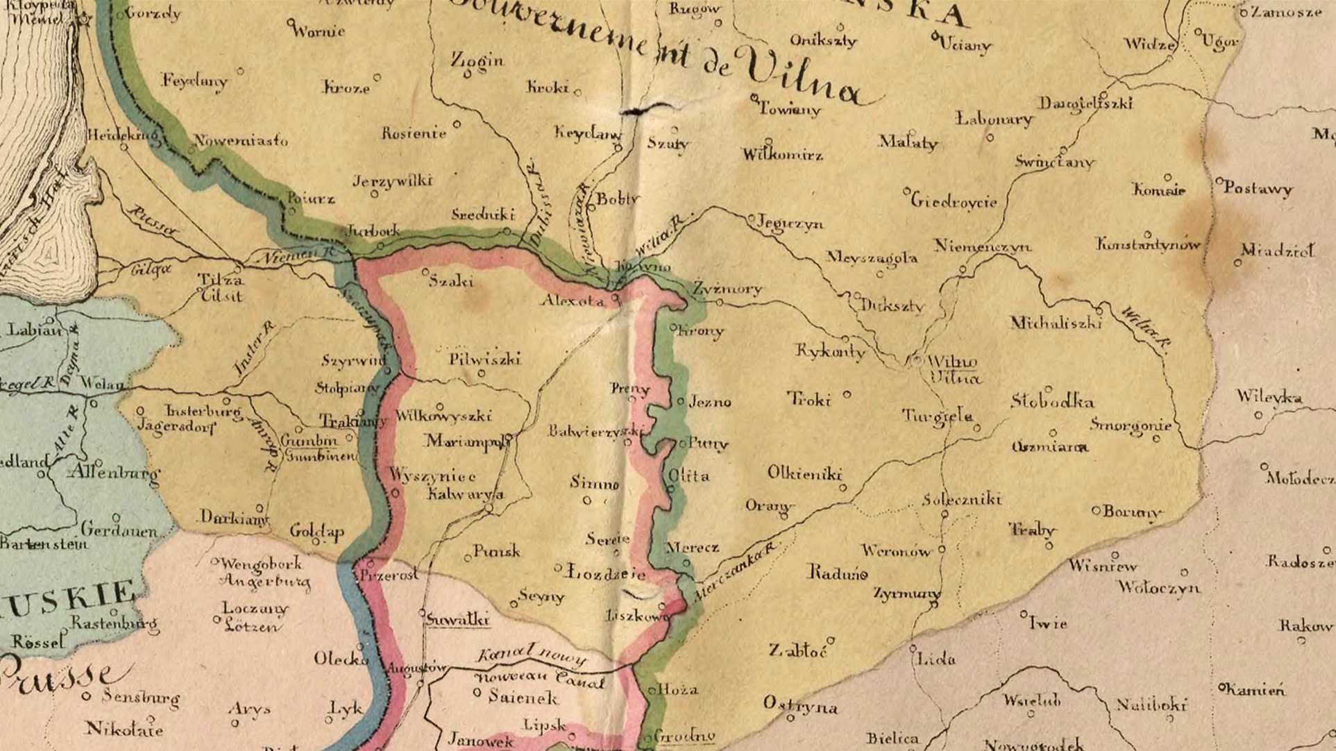
| 1847 |

1842 Pavel Josef Šafařík: "Slovanský
Zeměvid, 1842" (Slavic-settled Territories),
Prague, from a 1955 facsimilie edition of
Šafařík's 1842 "Slovanský Narodopis"
(Slavic ethnography). See the area ascribed
to "Slované" (Slavs) vs. "Litvané" (Lithu-
anians), and "Lotyši" (Latvians). From www.
historicalbalticmaps.com from Study Platform on
Interlocking Nationalisms: http://www.spinnet.eu

1873 [dated] Александр
Федорович Риттих (Alexander
Rittikh): "Этнографическая карта
Прибалтийского края"
(Ethnographic map of the Baltic
region), St. Petersburg, depicting
на́родно̄ст (nationality) from
Narva to Memel. From the digital
archive of the National Library of Estonia:
http://www.digar.ee
Федорович Риттих (Alexander
Rittikh): "Этнографическая карта
Прибалтийского края"
(Ethnographic map of the Baltic
region), St. Petersburg, depicting
на́родно̄ст (nationality) from
Narva to Memel. From the digital
archive of the National Library of Estonia:
http://www.digar.ee

1878 C. Perron (engraver) - Jacques
Élisée Reclus (geographer): "Lands of
the Lithuanians...according to
Dragomanov," from Reclus' "The
Universal Geography." From
its*now*vintage on eBay
Élisée Reclus (geographer): "Lands of
the Lithuanians...according to
Dragomanov," from Reclus' "The
Universal Geography." From
its*now*vintage on eBay


1864 Pompei Nikolaevich Batiushkov (artilleryman/mapmaker/government official in Kovno guberniya) - Aleksandr Fyodorivich Rittikh
(mapmaker/lieutenant colonel/ethnographer): "Атлас народонаселения Западно-русского края..." (Atlas of Confessions [Religions] Compiled
by the Ministry of Internal Affairs in the Head Office of the Organization of Orthodox Churches in the Western Provinces), 2nd Edition, St.
Petersburg, prepared 1862-64, and based on a combination of data compiled by the Russian Orthodox church and German statisticians like
Petr Keppen. The atlas has an overall map of western Russia, and nine individual guberniya maps of (four are shown here). Each guberniya
map has two parts: a color image of the area corresponding to the percentage of each confession, and details on the number of inhabitants of
both sexes in each district. The seven listed confessions (both Batiushkov and Rittikh contributed): Roman Catholic, Greek-Uniate, Orthodox,
Old Believers, Protestants, Jews and Muslims. The ten categories for "tribes" (Rittikh's primary focus in the atlas): Zhmud (Samogitians),
Lithuanians, Kurpaks, Mazurians, Poles, Great Russians, White Russians, Germans, Jews and Tatars. Statistical tables were in French,
German Latin, Russian and Polish. The impetus for creation of the atlas was insurrection in Poland and historic Lithuania against forced
conscription into the Russian military. The "January Uprising" (Pol.: powstanie styczniowe; Lith.: 1863 m. sukilimas, Bel.: Паўстанне 1863-
1864 гадоў) occurred in the former Polish-Lithuanian Commonwealth,beginning in Poland on 22 January 1863, and in the former Grand
Duchy beginning February 1, where it was led by Zygmunt Sierakowski, Antanas Mackevičius and Konstanty Kalinowski.The last
insurgents were captured in 1864. The atlas was used to identify non-Russian peoples and religions for Russification, and as source material
for the 1897 All-Russian census. Source for commentary: "Mapping Europe's Borderlands," Steven Seegel, 2012 and wikipeda. Source for the maps: www.
easteurotopo.org, which, in turn credited the University of California at Berkeley's Earth Sciences Library as the ultimate source for the maps.
| Distribution by cult of the nine western provinces of Russia |
| Kovno guberniya |
| Vilna guberniya |
| Grodno guberniya |
| Minsk guberniya |

1879 Jacques Élisée Reclus (geographer/
anarchist/nudist): "Peuples de l’Europe
Orientale," Paris, from “Nouvelle
Géographie Universelle. La Terre et les
Hommes,” published 1875-94 by
Hachette. Note that under the category
"Aryens divers" are "Lithuaniens," "Letts,"
"Tsiganes" (Roma) and "Grecs." From www.
karty.by
anarchist/nudist): "Peuples de l’Europe
Orientale," Paris, from “Nouvelle
Géographie Universelle. La Terre et les
Hommes,” published 1875-94 by
Hachette. Note that under the category
"Aryens divers" are "Lithuaniens," "Letts,"
"Tsiganes" (Roma) and "Grecs." From www.
karty.by

1906 Howard. B. Grose:
"Races of Immigrants,
Fiscal Year 1905," from
"Aliens or Americans?"
Dayton, Ohio, Home
Missionary Society of the
United Brethern Church.
Lithuanians Letts and
"Hebrews" are considered
Slavs. From "Persuasive
Maps: PJ Mode Collection," at
https://digital.library.
cornell.edu
"Races of Immigrants,
Fiscal Year 1905," from
"Aliens or Americans?"
Dayton, Ohio, Home
Missionary Society of the
United Brethern Church.
Lithuanians Letts and
"Hebrews" are considered
Slavs. From "Persuasive
Maps: PJ Mode Collection," at
https://digital.library.
cornell.edu
| Published 1908 |
| Published 1920 |
| Published 1908 |
| Published 1920 |
| Published 1908 |
| Published 1920 |
| Published 1908 |
| Published 1920 |
| Published 1908 |
| Published 1920 |
1920 de Schnakenburg:
"Lithuanie historique et
ethnographique," Riga.
From the Bibliotheque nationale
de France: www.gallica.bnf.fr
"Lithuanie historique et
ethnographique," Riga.
From the Bibliotheque nationale
de France: www.gallica.bnf.fr


1916 The Royal Geographic Society, under
the direction of the Geographic Section of
the General Staff, printed in 1915 by the
Ordnance Survey: "Ethnographical Map of
Central and South Eastern Europe," London.
In preparation for the peace conference that
was expected to follow World War I, the
British Foreign Office established a special
section responsible for preparing back-
ground information for use by British
delegates. This map is from "Maps of Poland,
Number 49," which contains eight foldout
maps.


c. 1916 (Anon.): "Carte ethnographique de la
Russie occidentale et des pays limitrophes en
Pologne et en Galicie," Paris (?), published by
J. Bermeiseffimp. Three detail images: the
table of populations, the area of the former
Grand Duchy, and the legend. The table
appears to be based on the 1897 Russian
census, but excludes Suvalkų g., where
Lithuanian-speakers comprised 52% of all.
The mapmaker mistakenly colored that
gubernia as Polish-speaking, but colored the
Vilnius area as Lithuanian-speaking. From the
National Library of France: http://gallica.bnf.fr

1913 Józef Gruenberg (mapmaker): "MAPA
ROZSIEDLENIA LUDNOŚCI POLSKIEJ NA
OBSZARZE DAWNEJ RZECZYPOSPOLITEJ
I KRAJÓW OŚCIENNYCH" (Map of the
Polish Population in the Former
Commomwealth and neighboring
countries), Lwow [Lwiw], 123 x 142 cm /
48.4 x 55.9 inches. Inset maps: Poles by
language and dialect (Podział ludności
polskiej na narzecza i gwary. Stan badań
dotychczasowych); % Germans (Pochód
Niemców ku ziemiom polskim); % Jews
(Procentowe rozmieszczenie Żydów). From
Antiquariat Dasa Pahor: www.pahor.de

| Library of Congress via World Digital Library: www.wdl.org |
| Daniel Crouch Rare Books: crouchrarebooks.com |

| 1920 "Karte von Litauen" |
1919 Isaiah Bowman (geographer/
cartographer): "Map and text delineating
boundaries of Poland, Lithuania, Western
Ukraine," depicting linguistic boundaries,
and the U.S.-recommended post-WWI
boundaries for those countries, from the
"Black Book," the American delegation’s
secret guiding document in Paris Peace
Conference negotiations. The book's
creation was led by Bowman. From ohns
Hopkins Libraries: http://exhibits.library.jhu.edu


1921 Marian Świechowski: "Mapa narodowościowa i polityczna
obszarów b. W. Ks. Litewskiego łącznie z tablicą statystyczną,
Wydawnictwo Tymczasowego Komitetu Politycznego Ziemi
Kowieńskiej" (Ethnic and Political Map of the Territories of the
Former Grand Duchy of Lithuania including a Statistical Chart,
Temporary Political Committee [of Poles] of the Kowno Region).
From http://marcinimatylda.blox.pl

1918 UK Naval Staff: "Poland:
Ethnographical Map." "The
ethnographical information for
Austria- Hungary and Poland is
derived from documents prepared
by the Naval Staff." One of four
sheets covering Poland, Germany,
Northern Italy and Southeastern
Europe. From the British Library:
www.bl.uk
Ethnographical Map." "The
ethnographical information for
Austria- Hungary and Poland is
derived from documents prepared
by the Naval Staff." One of four
sheets covering Poland, Germany,
Northern Italy and Southeastern
Europe. From the British Library:
www.bl.uk

1838 Augustin Grosselin (historian/geo-
grapher/linguist) - Alexandre Delamarche
(publisher): "Carte Ethnographique de
L'EUROPE," Paris, from "Atlas de
géographie physique, politique et
historique." Note the single color for
"Lithuaniens," "Coures," and Lotwanes,"
extending past the "Vilna" region almost to
"Grodno." From Vilnius University Library:
https://biblioteka.vu.lt via Tomas Nenartovic


1865 Michail Kojalovič
(Russian historian): "Carte
ethnographique de la Russie
occidentale et des pays
limitrophes en Pologne et en
Galicie," St. Petersburg. Note
"Lithuaniens" extending well
past "Vilna," except for small
pockets of Polonaise." From
Bayerischen Staatsbibliothek
München via Tomas Nenartovic
(Russian historian): "Carte
ethnographique de la Russie
occidentale et des pays
limitrophes en Pologne et en
Galicie," St. Petersburg. Note
"Lithuaniens" extending well
past "Vilna," except for small
pockets of Polonaise." From
Bayerischen Staatsbibliothek
München via Tomas Nenartovic

1874 [dated] Michail Fëdorovič
Mirkovič : "Этнографическая
карта славянского фолькер-
шафта из первого издания от
1867 года М. Ф. Мирковича"
(Ethnographic map of Slavic ethnic
groups in 1867), St. Petersburg.
From Vilnius University Library: https:
//biblioteka.vu.lt via Tomas Nenartovic
Mirkovič : "Этнографическая
карта славянского фолькер-
шафта из первого издания от
1867 года М. Ф. Мирковича"
(Ethnographic map of Slavic ethnic
groups in 1867), St. Petersburg.
From Vilnius University Library: https:
//biblioteka.vu.lt via Tomas Nenartovic


| "Этнографическая карта бѣлоруcского племени" www.romanticnationalism.net |
1903 Яўхім Фёдаравіч Карскі (Yefim Fyodorovich Karskiy) (Belarusian linguist/
ethnographer): "Этнографическая карта бѣлоруcского племени" (Ethnographic Map
of the Belarusan peoples), Warsaw. This map was the basis for the two contemporary
maps that followed. The second added shading for degrees of density. The third, by
Kazimier Lachnovič in 2010, added 1919 boundaries by ethnographer/historian
Мітрафан Віктаравіч Доўнар-Запольскі (Mitrofan Viktorovich Dovnar-Zapol'skiy)
and contemporary Belarus boundaries.
1914 Włodzimierz Wakar
(economist/statistician/
independence activist):
"Mapa Statystyczna
rozsiedlenia ludności pol-
skiej" (Statistical map of
Polish population),
Warsaw, showing areas
where Poles predominate.
From www.
karty.by
(economist/statistician/
independence activist):
"Mapa Statystyczna
rozsiedlenia ludności pol-
skiej" (Statistical map of
Polish population),
Warsaw, showing areas
where Poles predominate.
From www.
karty.by

| "межы расьсяленьня беларусаў" wikimedia |
| "Этнографическая карта бѣлоруcского племени" |
1333 Maria Regina
Korzeniowska: "Polska,
jednoczenie od roku
1333 - 1586" (Poland,
unification from the
years...), from her 1831
"Atlas historyczny,
genealogiczny,
chronologiczny i
geograficzny Polski."
"Litwa" and Zmujdz"
are just two of many
areas within "Poland."
From http://rcin.org.pl/
dlibra
Korzeniowska: "Polska,
jednoczenie od roku
1333 - 1586" (Poland,
unification from the
years...), from her 1831
"Atlas historyczny,
genealogiczny,
chronologiczny i
geograficzny Polski."
"Litwa" and Zmujdz"
are just two of many
areas within "Poland."
From http://rcin.org.pl/
dlibra


1884 "Этнографическая карта русского
народа в Европейской России и
Австрии" (Ethnographic map of the
Russian people in the European part of
Russia and Austria), St, Petersburg. From
http://elib.shpl.ru via Tomas Nenartovic
народа в Европейской России и
Австрии" (Ethnographic map of the
Russian people in the European part of
Russia and Austria), St, Petersburg. From
http://elib.shpl.ru via Tomas Nenartovic
1885 Александр Фёдорович Риттих
(Aleksandr Fedorovič Rittich) (carto-
grapher/ethnographer): "Litva i
Belorussija," from "Rittich, Aleksandr
Fedorovič: Slavjanskij Mir," Warsaw,
1885. From der Universitätsbibliothek
Giessen, via Tomas Nenartovic
(Aleksandr Fedorovič Rittich) (carto-
grapher/ethnographer): "Litva i
Belorussija," from "Rittich, Aleksandr
Fedorovič: Slavjanskij Mir," Warsaw,
1885. From der Universitätsbibliothek
Giessen, via Tomas Nenartovic

1887 Bibliographisches Institut Leipzig:
"Europa Volker und sprachenkarte,"
Leipzig , 11 3/4 x 9 3/4 inches, from
Meyers Lexicon. Note absence of Poles to
the east and south of "Litauer." From
heshke7 on eBay
"Europa Volker und sprachenkarte,"
Leipzig , 11 3/4 x 9 3/4 inches, from
Meyers Lexicon. Note absence of Poles to
the east and south of "Litauer." From
heshke7 on eBay
1878 Augustus Heinrich
Petermann (geographer) -
Aleksandr Fyodorovich
Rittikh (cartographer) -
Justus Perthes (publisher):
"Ethnographische Karte von
Russland..," Gotha, 98 x 64
cm. This is the German
edition of Rittikh's 1875 map.
From www.davidrumsey.com
Petermann (geographer) -
Aleksandr Fyodorovich
Rittikh (cartographer) -
Justus Perthes (publisher):
"Ethnographische Karte von
Russland..," Gotha, 98 x 64
cm. This is the German
edition of Rittikh's 1875 map.
From www.davidrumsey.com

1893 Julian Talko–
Hryncewicz (anthro-
pologist/ethnographer) :
"MAPA ETNO- LOGICZNA
ludów LITWY i RUSI," as
published in Zbiór
Wiadomości's Antro-
pologii Krajowej, from
the Herder Institute,
Marburg, Germany. Map
from the paper on this site by
Tomas Nenartovic
Hryncewicz (anthro-
pologist/ethnographer) :
"MAPA ETNO- LOGICZNA
ludów LITWY i RUSI," as
published in Zbiór
Wiadomości's Antro-
pologii Krajowej, from
the Herder Institute,
Marburg, Germany. Map
from the paper on this site by
Tomas Nenartovic


1901 Jan Michał Roz-
wadowski (linguist):
"Mapa języka litews-
kiego w gubernii
Wileńskiej” (Map of the
Lithuanian language in
Vilna province),
Cracow. From Biblioteka
Jagiellońska w Krakowie
via the paper on this site by
Tomas Nenartovic
wadowski (linguist):
"Mapa języka litews-
kiego w gubernii
Wileńskiej” (Map of the
Lithuanian language in
Vilna province),
Cracow. From Biblioteka
Jagiellońska w Krakowie
via the paper on this site by
Tomas Nenartovic

1000 William Shepherd:
DETAIL from "Europe and
the Byzantine Empire,"
from his 1926 "Historical
Atlas." Area ascribed to
Lithuanian tribes signifi-
cantly reduced; Poland's
boundaries significantly
enlarged. From
http://www.lib.utexas.edu/pcl
DETAIL from "Europe and
the Byzantine Empire,"
from his 1926 "Historical
Atlas." Area ascribed to
Lithuanian tribes signifi-
cantly reduced; Poland's
boundaries significantly
enlarged. From
http://www.lib.utexas.edu/pcl
1920 London
Geographical Institute -
George Philip & Son
(publisher): "Europe
Racial And Linguistic.”
From www.hipkiss.org
CAUTION: when you
try to go to this site, it
may attack your
computer or
smartphone!
Geographical Institute -
George Philip & Son
(publisher): "Europe
Racial And Linguistic.”
From www.hipkiss.org
CAUTION: when you
try to go to this site, it
may attack your
computer or
smartphone!


1897 - 1919 data,
published 1945 by the
US Office of Strategic
Services (OSS): "Poland
Language Map," using
data from Russian Census
of 1897, estimates in
1910, 1913, and a 1919
ordnance survey. From The
National Library of Poland:
https://polona.pl
published 1945 by the
US Office of Strategic
Services (OSS): "Poland
Language Map," using
data from Russian Census
of 1897, estimates in
1910, 1913, and a 1919
ordnance survey. From The
National Library of Poland:
https://polona.pl
1936 Friedrich Wilhelm Putzger (teacher/
cartographer) - Velhagen & Klasing
(publisher): "Deutscher Volks- und Kultur-
boden" (German Ethnic and Cultural Lands),
Bielefeld, from "F.W. Putzgers historischer
Schul-atlas," published from 1877 - 1979:
102 editions! Each black dot represents a
"large German colony," without defining
"large." "Litauen," colored yellow ("Area of
German speakers in the east"), contains 6
dots, as well as the number 35,000:
defined as the number of Germans. The
map gives credit to geographer Albrecht
Prenck, whose 1925 concept of Volks- und
Kultur-boden is considered as having
ushered in German geography a völkisch
(ethno-nationalistic) turn. Thus, critics
say, he paved the way for Nazi
"Lebensraum" policies and became an
accomplice in the resulting crimes. From
"Persuasive Maps: PJ Mode Collection:"
https://digital.library.cornell.edu


c. 1925 Kartographic
Inst.: "Baltu Tauto Zemes"
(Land if the Baltic Nation)
Riga. From ivofishing on eBay
Inst.: "Baltu Tauto Zemes"
(Land if the Baltic Nation)
Riga. From ivofishing on eBay

1915 [dated] Smith-
sonian Institution
report: "The Area of
Polish Speech, from
available sources."
From www.karty.by
sonian Institution
report: "The Area of
Polish Speech, from
available sources."
From www.karty.by
1919 [dated "compiled
1903"] П. Болотов
(Bolotov -- map compiler):
"Этнаграфічная карта
Беларус" (Ethnographic
map of Belarus), Warsaw,
with yellow from 1903:
based on work by Jan
Karski; line in red, 1919:
based on work by M.
Doŭnar-Zapolski. From
wikimedia
1903"] П. Болотов
(Bolotov -- map compiler):
"Этнаграфічная карта
Беларус" (Ethnographic
map of Belarus), Warsaw,
with yellow from 1903:
based on work by Jan
Karski; line in red, 1919:
based on work by M.
Doŭnar-Zapolski. From
wikimedia


1916 Eugeniusz Romer:
"Polacky/ Polonais,"
Vienna, from the first
edition of "The Great
Statistical and
Geo-"graphical Atlas of
Poland." This map shows
distribution and
percentage of Poles by
language. From
www.mapywig.org
"Polacky/ Polonais,"
Vienna, from the first
edition of "The Great
Statistical and
Geo-"graphical Atlas of
Poland." This map shows
distribution and
percentage of Poles by
language. From
www.mapywig.org
1193: Pre-Baltic Crusade
"Latvian Tribes." From
www.latviahistory.wordpress.
com
"Latvian Tribes." From
www.latviahistory.wordpress.
com


| Title Page |
| Tableau Ethnographique |
| Lithuaniens et Lettons |
| Polonais |
| Allemands |
| Russes |
| Israelites |
1863 Georg Ferdinand Robert d'Erckert was a captain in the Prussian army until 1850, when he was "loaned" to the Russian army on the personal recommendation of King Friedrich Wilhelm IV. He promptly converted
to Russian Orthodoxy, and Russified his name to Rodrikh Fyodorovich Erkert. He became well-known as a cartographer, and had published in 1863, by Berlin's Winkelmann & Sohn, in Berlin and St. Petersburg, the
Russian-language "Ethnographic Atlas of the West Russian Provinces and Neighboring Regions," as well as the French-language version of it: "Atlas ethnographique des Provinces habitees en totalite on en partie par des
Polonais." Published in the middle of the 1863-64 Polish Uprising, these six maps classify populations based on language. Thefirst map includes Germans, Poles, Lithuanians, little Russians/Belarussians, Czechs, Sorbs
and Jews, while the next five maps focus on individual nationalities. He considered Lithuanians and Latvians as acculturated Germans. All from www.davidrumsey.com

1831 [dated] Captain Ernst Heinrich
Michaelis (topographer/cartographer) -
Anton Edler (engraver) - Commission des
geographischen Depots, München
(publisher): "DAS ALTE UND NEUEN
POLEN," with inset tables by language and
religion, as well of histories and historical
boundaries. From Archiwum Państwowe w
Poznaniu: http://poznan.ap.gov.pl/ via www.
mapywig.org
1908 Roman
Dmowski (map-
maker/delegate
to Versailles
Peace Conf.): "Carte
Politique et
Ethnographique
de la Pologne,” from
his "Atlas do
dziejów Polski..."
Dmowski (map-
maker/delegate
to Versailles
Peace Conf.): "Carte
Politique et
Ethnographique
de la Pologne,” from
his "Atlas do
dziejów Polski..."

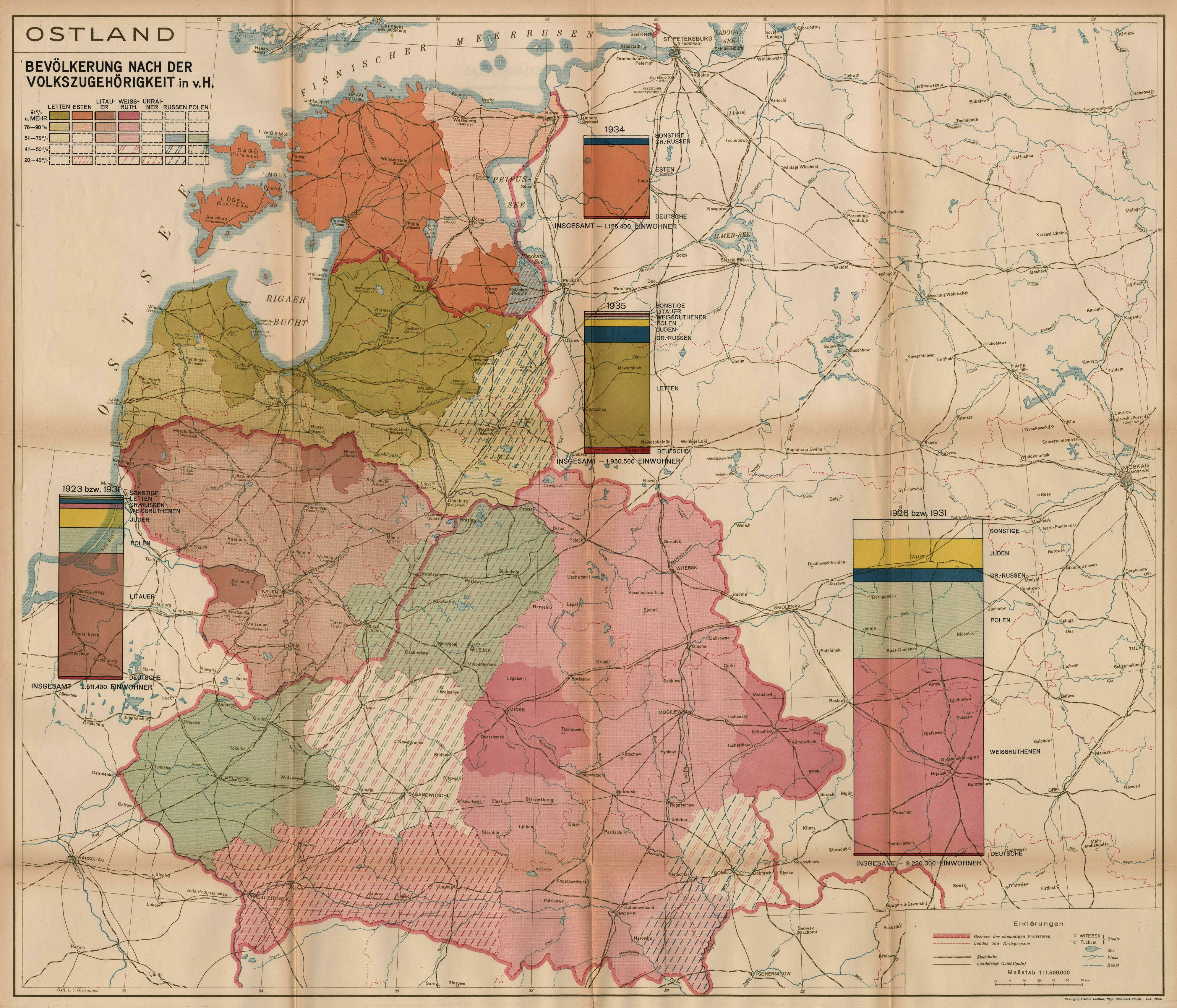

1918 Jovan Cvijić (Serbian geo-
grapher/ethnologist)) - Service Geo-
graphique de l'Arme (French Army
Geographic Service - mapmaker):
"Riga," one of six "ethnographic maps
of central Europe loaned to the Peace
Conference at Versailles, 1918-19." No
legend on the map, so you would have
to infer coloring representing Livs,
Germans, and Latvians. From the
American Geographical Society collection at
the Univ. of Wisconsin, Milwaukee: https:
//collections.lib.uwm.edu/
1929 "Europa Etno-
graphica," from the 3rd
edition of "Atlante inter-
nazionale del Touring
club italiano." Depicts,
among other groups,
under "Ugro-Finni,"
"Ciuti" in "Estoni i Livoni,"
and, under "Slavo-Lettoni,"
"Lituani" and "Lettoni
(Latgaliani)." From
www.davidrumsey.com
graphica," from the 3rd
edition of "Atlante inter-
nazionale del Touring
club italiano." Depicts,
among other groups,
under "Ugro-Finni,"
"Ciuti" in "Estoni i Livoni,"
and, under "Slavo-Lettoni,"
"Lituani" and "Lettoni
(Latgaliani)." From
www.davidrumsey.com

c. 1930 "Carte de la Repartition:
population polonaise territoire historique
Pologne" (Distribution of Polish population
across areas of former Poland), based on
data from the 1897 Russian census, and
early 20th century Prussian censuses.
From Składnica Map Biblioteki Wydziału Nauk o
Ziemi Uniwersytetu Śląskiego, via www.mapywig.
org

1935 [dated] "Die Verbreitung der
Deutschen in Litauen auf Grund der
amtlichen litauischen Volkszahlung vom
17. September 1923 dargestellt..." (The
distribution of the Germans in Lithuania
based on the official Lithuanian national
payment of September 17, 1923) Berlin.
From University of Wisconsin, Milwaukee,
Libraries: https://collections.lib.uwm.edu/

1921 Bogdan Zaborski (geo-
grapher/ethnographer) -
Stanisław Lencewicz (geo-
grapher): "Mapa etnograf-
iczna Polski." From https:
//collections.lib.uwm.edu/
grapher/ethnographer) -
Stanisław Lencewicz (geo-
grapher): "Mapa etnograf-
iczna Polski." From https:
//collections.lib.uwm.edu/
1919 [dated] Edward
Malizewski (mapmaker/
ethnographer): "Map of
Nationalities in Poland,"
Warsaw, 61 x 67 cm,
with 11 color-coded
nationalities/religions.
From Univ. of Wisconsin,
Milwaukee, Libraries:
https://collections.lib.uwm.
edu/
Malizewski (mapmaker/
ethnographer): "Map of
Nationalities in Poland,"
Warsaw, 61 x 67 cm,
with 11 color-coded
nationalities/religions.
From Univ. of Wisconsin,
Milwaukee, Libraries:
https://collections.lib.uwm.
edu/


c. 1919 Litografia
Artystyczna W. Głow-
czewski (publisher):
DETAIL, "Ludność Ziem
Polskich” (Population of
Polish Lands), Warsaw,
depicting areas by
concentration of Poles,
Russians, Belarusians,
Lithuanians, Latvians
and Germans. From www.
mapywig.org
Artystyczna W. Głow-
czewski (publisher):
DETAIL, "Ludność Ziem
Polskich” (Population of
Polish Lands), Warsaw,
depicting areas by
concentration of Poles,
Russians, Belarusians,
Lithuanians, Latvians
and Germans. From www.
mapywig.org

1921 Antoni Sujkowski: “Mapa Gęstości
Zaludnienia” (Map of the density of the
population), Lwów, from his“Geografa
ziem dawnej Polski.” From Śląska Biblioteka
Cyfrowa via www.mapywig.org
Zaludnienia” (Map of the density of the
population), Lwów, from his“Geografa
ziem dawnej Polski.” From Śląska Biblioteka
Cyfrowa via www.mapywig.org

c. 1921 E. Romer and T. Szumański (carto-
grapher): "Mapa etnograficzna Ziem Wschod-
nich (Polska Litwa i Bialorus)..," Lwów, based
on the 1919 census. From Podlaska Biblioteka
Cyfrowa via www.mapywig.org
grapher): "Mapa etnograficzna Ziem Wschod-
nich (Polska Litwa i Bialorus)..," Lwów, based
on the 1919 census. From Podlaska Biblioteka
Cyfrowa via www.mapywig.org

c. 1936 "WILNO and north-eastern
POLAND, Percentage of population
of POLISH nationality according to
the 1931 Census," Warsaw, 20 x 18
cm, depicting areas from over 50%
to 20 - 29.9%. From Univ. of Wisconsin,
Milwaukee, Libraries: https://
collections.lib.uwm.edu/
POLAND, Percentage of population
of POLISH nationality according to
the 1931 Census," Warsaw, 20 x 18
cm, depicting areas from over 50%
to 20 - 29.9%. From Univ. of Wisconsin,
Milwaukee, Libraries: https://
collections.lib.uwm.edu/

| Wroblewski Library of the Lithuanian Academy of Sciences: elibrary.mab.lt/ |
| Stanford Univ. Libraries: www.searchworks.stanford.edu |

1930 "Mapa Belorusi,"
depicting the ethno-
graphic boundaries of
Belarus, the actual
boundaries of the
B.S.S.R., and the lands
"taken" by Latvia,
Poland, and Russia. From
www.karty.by
depicting the ethno-
graphic boundaries of
Belarus, the actual
boundaries of the
B.S.S.R., and the lands
"taken" by Latvia,
Poland, and Russia. From
www.karty.by

1918 Henryk Arctowski
(geophysicist/mapmaker,
part of the U.S. team at
Versailles) - American
Commision to Negotiate
Peace (publisher): "Pre-
liminary Report on
Poland: Percent of Polish
Population in Poland and
Lithuania," with lines
and percentage shand-
drawn on a Russian
map showing results of
the 1897 census. From
National Archives catalog:
www.archives.gov

c. 1920 Lietuvos ūkininkas (The Lithuanian
Farmer newspaper/mapmaker): "Die
gegenwärtige Grenzen der litauischen
Sprache" (The current boundaries of the
Lithuanian language), focused on the areas
that would soon become part of inter-war
Poland. From Martynas Mažvydas National
Library of Lithuania: https://www.lnb.lt/
Farmer newspaper/mapmaker): "Die
gegenwärtige Grenzen der litauischen
Sprache" (The current boundaries of the
Lithuanian language), focused on the areas
that would soon become part of inter-war
Poland. From Martynas Mažvydas National
Library of Lithuania: https://www.lnb.lt/

2017 Renata3 (on wikipedia): "Etno-
graphic regions of Lithuania (based on
19th century culture)."Self-made using
Inkscape. Background: from image:
LithuaniaPhysicalMap-Clean.svg by
user:Knutux. Factual information is from
map of etnographic regions by Centre for
cartography, Vilnius University
graphic regions of Lithuania (based on
19th century culture)."Self-made using
Inkscape. Background: from image:
LithuaniaPhysicalMap-Clean.svg by
user:Knutux. Factual information is from
map of etnographic regions by Centre for
cartography, Vilnius University