Maps: 1621 - 1650
1627 John Speed: "A NEWE MAPE OF
POLAND." Possibly from his "A Prospect of
the Most Famous Parts of the World," first
published by George Humble in 1627.
From cichecki.net/bebeln0
POLAND." Possibly from his "A Prospect of
the Most Famous Parts of the World," first
published by George Humble in 1627.
From cichecki.net/bebeln0

1628 Gerard Mercator: "LITHVANIA," 16
1/2 x 14 1/2 inches / 420 x 370 mm, from
one of the last unaltered editions of
Mercator's atlas -- the 1628 French edition.
1/2 x 14 1/2 inches / 420 x 370 mm, from
one of the last unaltered editions of
Mercator's atlas -- the 1628 French edition.


| 1630 Willem Blaeu': "TABVLA RVSSIAE." A Hessel Gerritz map having a detailed map of Moscow. Also a DETAIL image. See the 1640 Merian version below. |

1630 Jan Cloppenburgh
(Amsterdam publisher) -
Gerard Mercator:
'LITHUANIA," from his
"Gerardi Mercatoris Atlas
sive Cosmographicae
Meditationes...," in
editions dated 1630, '32
and '36.
(Amsterdam publisher) -
Gerard Mercator:
'LITHUANIA," from his
"Gerardi Mercatoris Atlas
sive Cosmographicae
Meditationes...," in
editions dated 1630, '32
and '36.
1632: Jan Cloppenburgh -
Gerard Mercator:
"LITHUANIA," 9.7 x 7
inches, engraved by
Petrus Kaerius, from
"Atlas Minor." From Old
World Auctions.
Gerard Mercator:
"LITHUANIA," 9.7 x 7
inches, engraved by
Petrus Kaerius, from
"Atlas Minor." From Old
World Auctions.


1633 Gerard Mercator: "LITHVANIA."
Engraved in Duisburg circa 1590,
printed in Amsterdam 1633. 43.5 cm x
37 cm. Mercator's three-volume “Atlas,
sive Cosmographicae Meditationes de
Fabrica Mundi” was first published
1595. J. Hondius reissued the atlas from
1604-34. Dates for maps from this atlas
are most often guesses. AK-05.
Engraved in Duisburg circa 1590,
printed in Amsterdam 1633. 43.5 cm x
37 cm. Mercator's three-volume “Atlas,
sive Cosmographicae Meditationes de
Fabrica Mundi” was first published
1595. J. Hondius reissued the atlas from
1604-34. Dates for maps from this atlas
are most often guesses. AK-05.

| 1634 Willem Blaeu: "PRVSSIAE NOVA TABVLAE," Amsterdam. 19.5 x 15 inches. Also a DETAIL image. From www.raremaps.com |


1635 Willem Blaeu:
"TABVLA RUSSIAE,"21 x
17.5 inches. Engraved by
Hessel Gerritsz in 1613, based on information from Isaac
Massa. Blaeu acquired the plate after Gerritsz's death in
1632. From www.raremaps.com
"TABVLA RUSSIAE,"21 x
17.5 inches. Engraved by
Hessel Gerritsz in 1613, based on information from Isaac
Massa. Blaeu acquired the plate after Gerritsz's death in
1632. From www.raremaps.com
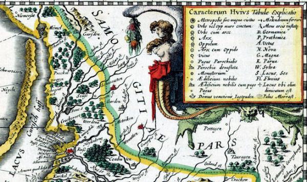
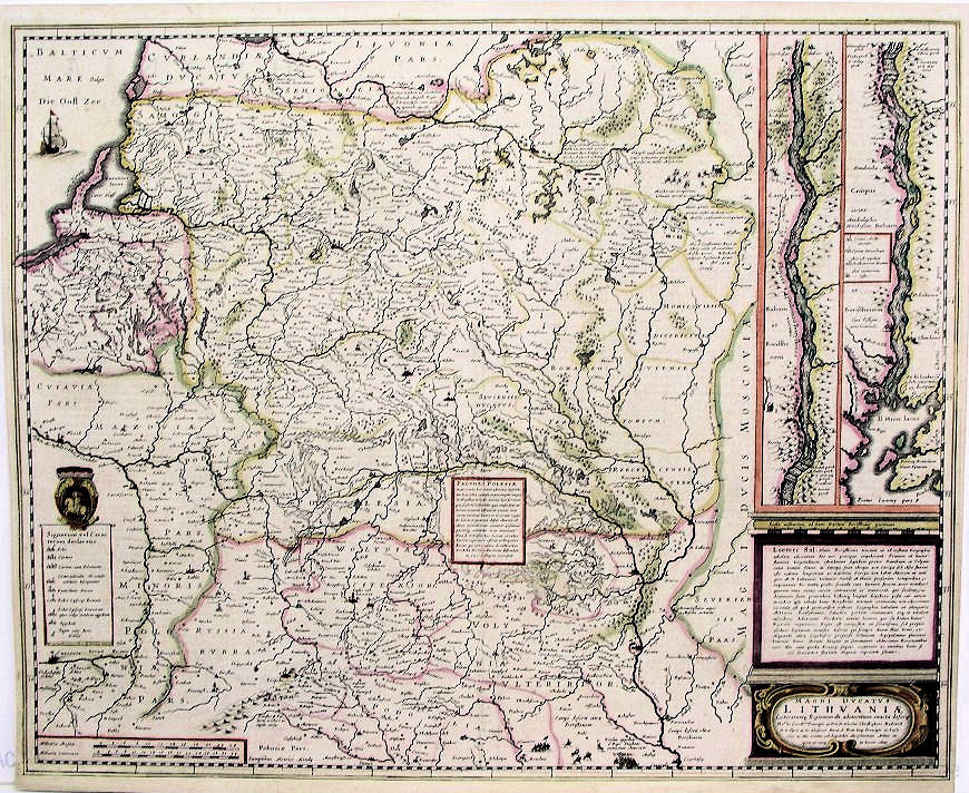
1636 & 1640 & 1699 Johannes Janssonius "MAGNI
DVCATVS LITHVANIAE," Amsterdam, 22 x 18.5
inches, in a version published 1636 on the left,
ollowed by two 1640 versions(the first also having a DETAIL image), followed, on the right, by a 1699 version of the same map -- the only one published
in Paris, instead of Amsterdam.
DVCATVS LITHVANIAE," Amsterdam, 22 x 18.5
inches, in a version published 1636 on the left,
ollowed by two 1640 versions(the first also having a DETAIL image), followed, on the right, by a 1699 version of the same map -- the only one published
in Paris, instead of Amsterdam.


1638 Matthaus Merian: "MAGNI
DVCATVS LITHVANIAE," Frankfurt,
12.75 x 14.5 inches. From his
"Topographia Germaniae." AK-26
DVCATVS LITHVANIAE," Frankfurt,
12.75 x 14.5 inches. From his
"Topographia Germaniae." AK-26

1646 Speed - Pieter van
den Keere (engraver):
"POLONIA," London, 8.6
x 12.3 cm. From
www.robertfrew.com
den Keere (engraver):
"POLONIA," London, 8.6
x 12.3 cm. From
www.robertfrew.com
1647 Abraham Ortelius:
"PRVSSIAE DESCRIP."
Venice, from Pietro
Querini's 1647 edition of
Abraham Ortelius'
"Theatro del Mondo."
"PRVSSIAE DESCRIP."
Venice, from Pietro
Querini's 1647 edition of
Abraham Ortelius'
"Theatro del Mondo."
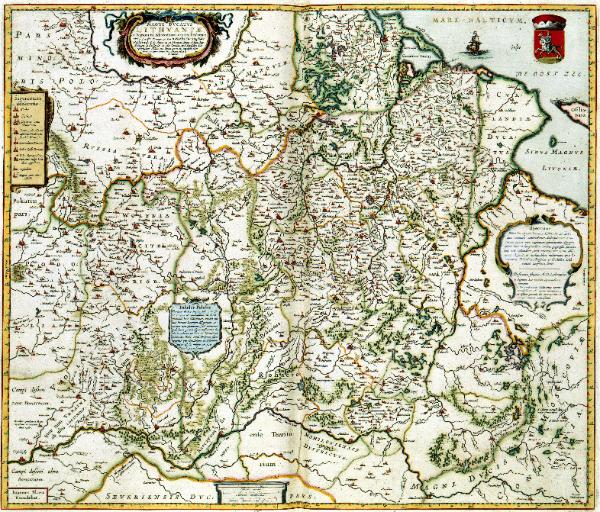
1648 Willem Blaeu: "MAGNI DVCATVS LITHVANIAE," dedicated to the Radziwils, Lithuanians who ordered Maciej Strubicz to map the area in 1584-95. In 1613
Johannes Jansonnius published a Hessel Gerritsz-engraved copy of that map; Blaeu copied and published it in 1648. From Konnklijke Bibliotheek, The Hague
Johannes Jansonnius published a Hessel Gerritsz-engraved copy of that map; Blaeu copied and published it in 1648. From Konnklijke Bibliotheek, The Hague


1649 Philippe Briet: "LE
ROYAVME DE
POLOGNE." 195 x 155
mm, Paris, from "
Theatre Geographique de
Europe." From
www.antiquarius-sb.com
ROYAVME DE
POLOGNE." 195 x 155
mm, Paris, from "
Theatre Geographique de
Europe." From
www.antiquarius-sb.com

1650 Pierre Mariette: "LA SCANDINAVIE ou sont les Estats de SVEDE, NORWEGVE et DANEMARCK," Paris, 21 x
17 inches. One of the earliest maps of Scandinavia published in Paris. Also a DETAIL image. From
www.raremaps.com
17 inches. One of the earliest maps of Scandinavia published in Paris. Also a DETAIL image. From
www.raremaps.com


1630 Johannes Janssonius: "Livonia,"
Amsterdam, 18 x 14 cm, from Mercator's
"Atlas Minor." From www.nlib.ee
Amsterdam, 18 x 14 cm, from Mercator's
"Atlas Minor." From www.nlib.ee

1638, 1641 and 1642 versions of Johannes Janssonius: "NOVA TOTIVS LIVONIAE accurata Defcriptio.," Amsterdam, 50 x 37 cm,
from "Nouveau theatre du mode ou nouvel atlas." The 1638 and 1641 versions are from the Unv. of Tartu:
http://dspace.utlib.ee/dspace/handle/10062/2896; the 1642 version is from www.nlib.ee
from "Nouveau theatre du mode ou nouvel atlas." The 1638 and 1641 versions are from the Unv. of Tartu:
http://dspace.utlib.ee/dspace/handle/10062/2896; the 1642 version is from www.nlib.ee


1628 Sebastian Munster:
"Europa nach
gelegenheit," from
"Cosmographia, Das ist
Beschreibung der ganzen
Welt," Basel. With a
DETAIL image. From
www.nic.funet.fi
"Europa nach
gelegenheit," from
"Cosmographia, Das ist
Beschreibung der ganzen
Welt," Basel. With a
DETAIL image. From
www.nic.funet.fi

1640 Matthaus Merian: "TABULA RUSSIAE."
Merian's edition of the Hessel Gerritsz map of
Russia. Compare with the 1630 Blaeu
version. From www.raremaps.com
Merian's edition of the Hessel Gerritsz map of
Russia. Compare with the 1630 Blaeu
version. From www.raremaps.com

1623 Gerard Mercator: "LITHVANIA,"
Amsterdam, 44 x 37.5 cm, from his "Atlas
sive Cosmographica," first published in
1595. This map was from an edition
augmented and published by J. Hondius.
Amsterdam, 44 x 37.5 cm, from his "Atlas
sive Cosmographica," first published in
1595. This map was from an edition
augmented and published by J. Hondius.


1630 Gerard Mercator's map, reissued by
Hondius: "LIVONIA," Amsterdam, 47 x 36
cm. From www.jpmaps.co.uk
Hondius: "LIVONIA," Amsterdam, 47 x 36
cm. From www.jpmaps.co.uk

1628 Gerard Mercator - Jodocus Hondius: "LIVONIA SIVE LIEFLAND,"
Amsterdam. From Mercator's "Atlas Minor," as issued by Hondius. Map on the left
from www.swaen.com; on the right, from the Unv. of Tartu:
http://dspace.utlib.ee/dspace/handle/10062/2896
Amsterdam. From Mercator's "Atlas Minor," as issued by Hondius. Map on the left
from www.swaen.com; on the right, from the Unv. of Tartu:
http://dspace.utlib.ee/dspace/handle/10062/2896


