Maps: 1652 - 1675

1652 Vaclovas Grodeckis - Johann
Kinckius: "Poloniæ finitimarum..."
Kinckius: "Poloniæ finitimarum..."
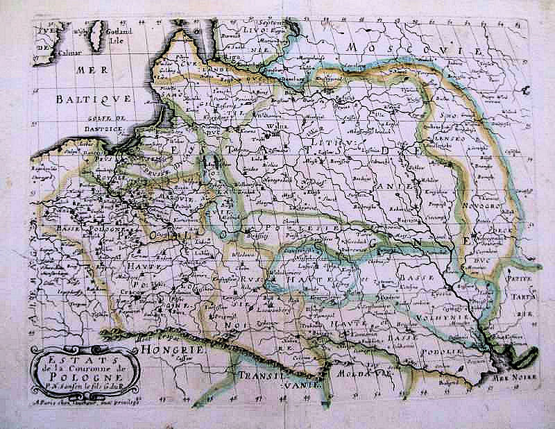
1655 Nicholas Sanson:
"ESTATS de la Couronne de
POLOGNE," Paris, 25.3 x
19.1 cm, from "L'Europe en
plusieurs." From
www.mapmogul.com
"ESTATS de la Couronne de
POLOGNE," Paris, 25.3 x
19.1 cm, from "L'Europe en
plusieurs." From
www.mapmogul.com
c. 1658 Gabriel Bucelin (Swiss genealogist/mapmaker): "LITHUANIA Obiter
Adumbrata," Ulm, 10.5 x 6.3 cm, from the first edition of "Praecipuarum Universi
Terrarum Orbis." Historians criticized the map as uninformative (no Vilnius, Trakai,
Kaunas, etc.) and as an imprecise copy of Ortelius' or J. Jansonius’ maps. Created to
illustrate the expansion of Protestantism in Lithuania. Published six times between
1650 and 1678.
1659 [dated] Nicholas Sanson: "La Curlande duché et Semigalle autrefois de la
Livonie, la Samogitie duché en Lituanie," Paris, 16 x 25 inches, in three versions of
his double-page map, executed while Sanson was officially "Geographer to the King."
(AK-25)
Livonie, la Samogitie duché en Lituanie," Paris, 16 x 25 inches, in three versions of
his double-page map, executed while Sanson was officially "Geographer to the King."
(AK-25)
1661 Pieter van den Keere (engraver) - Philipp Clüver: "LITHUANIA," Amsterdam, 6
x 8 inches, from Jansson's edition of "Introductionis in Universam Geographium."
x 8 inches, from Jansson's edition of "Introductionis in Universam Geographium."

Philipp Cluver: "Veteris et Novæ Regni Poloniæ Magniq Ducatus Lithuaniæ..," in the
first Latin version of the plate, from "Introductionis in Universam Geographicum."
The map was published in various sizes, and in three different states of the plate, until
1729, and was likely engraved by Petrus Bertius.
first Latin version of the plate, from "Introductionis in Universam Geographicum."
The map was published in various sizes, and in three different states of the plate, until
1729, and was likely engraved by Petrus Bertius.
1663 [dated] Pierre Moulart Sanson - Jean Somer (engraver) - Pierre Mariette
(publisher): "Estats de la Couronne de POLOGNE ou sont les Royaume de Pologne,
Duches et Provinces de Prusse, Cuiave, Mazovie, Russie Noire &c.," Paris. 16.7 x 22 .5
inches / 425 x 571 mm, in versions of the 2nd State of the plate.
(publisher): "Estats de la Couronne de POLOGNE ou sont les Royaume de Pologne,
Duches et Provinces de Prusse, Cuiave, Mazovie, Russie Noire &c.," Paris. 16.7 x 22 .5
inches / 425 x 571 mm, in versions of the 2nd State of the plate.

1665-66 Nicholas Sanson (Geographer to the King) - Abraham Peyrounin (engraver): "Partie de Lithuanie ou sont les Palatinats de...," Paris. A series of maps illustrating The Grand Duchy of
Lithuania's administrative regions. Multiple versions are shown. Compare with the c1709 versions published by Nicolas' son Guillaume
Lithuania's administrative regions. Multiple versions are shown. Compare with the c1709 versions published by Nicolas' son Guillaume
c. 1667 Abraham Ortelius (original mapmaker) - Philip
Galle (copied 1593 publisher) - Pietro Maria Marchetti
(publisher): "POLONIÆ DESCRIPTIO," Venice, in two
versions, 2 7/8 x 4 inches. From "Il Theatro del
Mondo," often referred to as the plagiarized version of
Ortelius' "Epitome." Compare with the 1655 version.
Italian editions of this map were published until 1697.

1675 [dated] Nicholas Sanson - Alexis-Hubert Jaillot: "Estats de La Couronne de Pologne:
ou sont les Royaume de Pologne, Duchés et provinces de Prusse, Cuiavie, Mazovie, Russie
Noire &c. Duchés de Lithuanie, Volhynie, Podolie &c. de L'Ukraine &c.”" Paris, 88.5 x 60
cm., made up of two joined maps.
ou sont les Royaume de Pologne, Duchés et provinces de Prusse, Cuiavie, Mazovie, Russie
Noire &c. Duchés de Lithuanie, Volhynie, Podolie &c. de L'Ukraine &c.”" Paris, 88.5 x 60
cm., made up of two joined maps.

1655 [dated] Nicholas Sanson: "Estats de la Couronne de POLOGNE ou sont les
Royaume de Pologne... Duchés de Lithuanie, Volhynie Podelie etc...de l'Ukranie etc.,"
Paris, double- page map in the 1st State, 22.5 x 17 inches. See the 1663 and 1708
versions.
Royaume de Pologne... Duchés de Lithuanie, Volhynie Podelie etc...de l'Ukranie etc.,"
Paris, double- page map in the 1st State, 22.5 x 17 inches. See the 1663 and 1708
versions.

1658 August Gudicanus (mapmaker) - Johann Antonius
Kinckius (publisher): "Nova Descriptio Totius Regni
POLONICI Nec non. Magni Ducatus LITHUANIÆ..." Köln,
12 x 12.9 inches, from "Polonia sive nova regni
Poloniӕ..."
Kinckius (publisher): "Nova Descriptio Totius Regni
POLONICI Nec non. Magni Ducatus LITHUANIÆ..." Köln,
12 x 12.9 inches, from "Polonia sive nova regni
Poloniӕ..."

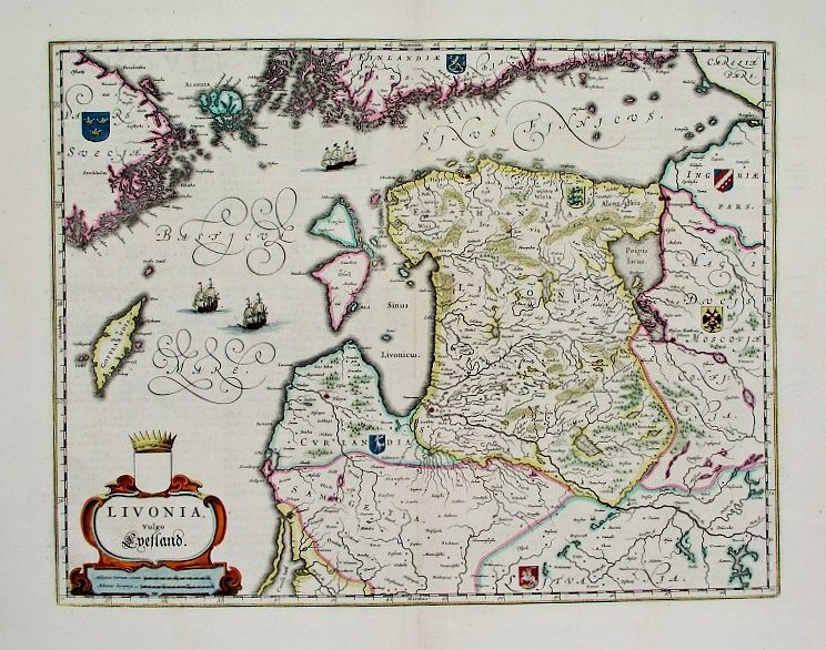
Joan Blaeu (publisher): "LIVONIA Vulgo Lyefland," Amsterdam, 48 x 37 cm./ 15.125 x 19.5 inches, in five versions (the best images are the first
and fifth ones): two from 1662, and a third from 1664, the c1662-65 and 1665 from "Atlas Maior, Sive Cosmographia Blauiana," Volume 2 of 11.
Published in French, Dutch, German, and Spanish; the Latin version was also sold with V. 1 dated 1665 and V. 2-11 dated 1662. The atlas is
considered by many to be the greatest atlas ever published, both in its own time and even today.

| "...Wilna et Troki...et Partie du Palat. de Minsk." www.davidrumsey.com |
| "...Nowogrodeck Litawski...lePalatinat de Bressici en Polesie...et Partie de Minsk..." Wroblewski Library of the Lithuanian Academy of Sciences: elibrary.mab.lt/ |

| "...Minsk et Mseislaw...et partie des Dvches de Novogradeck..." www.davidrumsey.com |

| "...Poloczk, Witepsk, Mseislaw, et partie de Minsk..." www.davidrumsey.com |
| "...Wilna et Troki...et Partie du Palat. de Minsk." wikimedia |
1659 Adam Olearius (mapmaker) - Jean Du Puis (publisher): "Carte de
la Livonie ou Lifland," Paris, 28 x 28 cm., from "Relation du voyage d’
Adam Olearius en Moscovie, Tartarie et Perse : Tom I, part 1."
la Livonie ou Lifland," Paris, 28 x 28 cm., from "Relation du voyage d’
Adam Olearius en Moscovie, Tartarie et Perse : Tom I, part 1."
1666 Pierre Duval: "LES ROYAUMES DU
NORT ou Sont principalement LES ETATS
DE LA COURONNE de POLOGNE," Paris,
15.7 x 21.9 inches / 40 x 55.4 cm. From
www.raremaps.com
NORT ou Sont principalement LES ETATS
DE LA COURONNE de POLOGNE," Paris,
15.7 x 21.9 inches / 40 x 55.4 cm. From
www.raremaps.com

1663 [dated] Nicolas Sanson I (d'Abbeville) - Chez
Pierre Mariette (publisher): "La Livonie Duche..," Paris,
from "Geographia Cartes Generales de la Nouvelle
Ancienne." See the 1697 version, also dated "1663."
Pierre Mariette (publisher): "La Livonie Duche..," Paris,
from "Geographia Cartes Generales de la Nouvelle
Ancienne." See the 1697 version, also dated "1663."


1657 Johannes Janssonius: "MAGNI DVCATVS
LITHVANIÆ," Amsterdam, 24 x 20 inches. A
reduction of the original 1613 Gerritsz - Blaeu map,
this version was published in many editions. See, at
this site, versions from 1636, 1640, 1650, 1660-80,
and 1699. From old-leaf on eBay
LITHVANIÆ," Amsterdam, 24 x 20 inches. A
reduction of the original 1613 Gerritsz - Blaeu map,
this version was published in many editions. See, at
this site, versions from 1636, 1640, 1650, 1660-80,
and 1699. From old-leaf on eBay
| 1662 http://www.nlib.ee/ |

1652 Matthaus Merian: "LIVONIA vulgo Lyefland,"
28.3 x 38 cm., in two versions.
28.3 x 38 cm., in two versions.

1655 Abraham Ortelius:
"POLONIÆ DESCRIPTO,"
from Turrini's “Theatro
del Mondo di Abramo
Ortelio." From antiqua.
trinacria
"POLONIÆ DESCRIPTO,"
from Turrini's “Theatro
del Mondo di Abramo
Ortelio." From antiqua.
trinacria

1668 Pieter van den
Keere: "Polonia," London,
5 x 3.5 inches, published
by Roger Rea in "A
Prospect of the Most
Famous Parts of the
World," one of the so-
called "miniature Speeds"
from a pocket edition of
Speed's atlas. Only the
text from Speed's atlas
was used, but with van
den Keere's maps. From
linidsfarne2 on eBay

1673 Gerard Mercator - Jodocus Hondius: "LIVONIA,"
Amsterdam, 7.2 x 10 inches, in two examples from the
fourth and last series of reduced versions of Mercator's
atlas published by Amsterdam bookseller Jan Cloppen-
burgh. The maps were re-engraved by Pieter van der
Keere and are larger than in preceding editions.
Amsterdam, 7.2 x 10 inches, in two examples from the
fourth and last series of reduced versions of Mercator's
atlas published by Amsterdam bookseller Jan Cloppen-
burgh. The maps were re-engraved by Pieter van der
Keere and are larger than in preceding editions.


1666 Janssonius Family: "Nova totivs
Livoniæ accurata Descriptio," Amster-
dam, 392 x 545 mm. From the National
Library of Latvia: www.lnb.lv
Livoniæ accurata Descriptio," Amster-
dam, 392 x 545 mm. From the National
Library of Latvia: www.lnb.lv

| 1662 www.davidsongalleries.com |


1654 Pierre Duval: "Carte
de Pologne et des Estats qui
en dependent ," Paris, 20.5
x 15.5 inches. From
www.raremaps.com
de Pologne et des Estats qui
en dependent ," Paris, 20.5
x 15.5 inches. From
www.raremaps.com


Pierre Duval: "POLOGNE Royaume Electif." Paris, 3 7/8 x 4 13/16 inches, from "La Geographie Universelle."

1655 Abraham Ortelius:
"Livonia/ Livoniæ Nova
Descriptio Ioanne Portan-
ti O Auctore,' Venice, from
an Italian 'pirate' edition:
'Il Theatre del Mondo'
"Livonia/ Livoniæ Nova
Descriptio Ioanne Portan-
ti O Auctore,' Venice, from
an Italian 'pirate' edition:
'Il Theatre del Mondo'
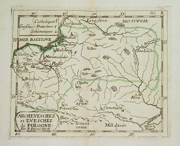
1662 Pierre Duval:
"Archeveschez et Eveschez
de Pologne," from Duval's
Ecclesiastical Atlas." From
antiquaries-sb.com
"Archeveschez et Eveschez
de Pologne," from Duval's
Ecclesiastical Atlas." From
antiquaries-sb.com


Joahannes Blaeu: "Magni Dvcatvs Lithvaniæ et
Regionum Adiacentium exacta Descriptio...,"
Amsterdam, 22 x 19 inches / 45 x 53 cm, from his
11-volume "Atlas Maior Sive Cosmographia ..," the first
Latin version published 1662, later editions in French,
Dutch, German, and Spanish.
Regionum Adiacentium exacta Descriptio...,"
Amsterdam, 22 x 19 inches / 45 x 53 cm, from his
11-volume "Atlas Maior Sive Cosmographia ..," the first
Latin version published 1662, later editions in French,
Dutch, German, and Spanish.

1660-1680 Janssonius Heirs Heirs :
"Magni Dvcatvs Lithvaniæ," Amster-
dam, 24 x 20 inches, in a reduction of
the "1613" Gerritsz/Blaeu map pub-
lished by J.J. van Waesbergen, with a
label for "Memel." From Biblioteca Virtual
del Patrimonio Bibliográfico
www.bvpb.mcu.es
"Magni Dvcatvs Lithvaniæ," Amster-
dam, 24 x 20 inches, in a reduction of
the "1613" Gerritsz/Blaeu map pub-
lished by J.J. van Waesbergen, with a
label for "Memel." From Biblioteca Virtual
del Patrimonio Bibliográfico
www.bvpb.mcu.es

| "...Poloczk, Witepsk, Mseislaw, et partie de Minsk..." Wroblewski Library of the Lithuanian Academy of Sciences: elibrary.mab.lt/ |

| "...Nowogrodeck Litawski...lePalatinat de Bressici en Polesie...et Partie de Minsk..." www.raremaps.com |


1670 Carel Allard
(engraver/publisher):
"Regni Poloniæ, Magni
Ducatus Lithuaniae...,"
Amsterdam, 50 × 58.50
cm / 19.7 x 23 inches,
from his "Atlas Major,"
issued in multiple un-
dated editions by Carel
and later by his son Hugo.
From wikiwand.com
(engraver/publisher):
"Regni Poloniæ, Magni
Ducatus Lithuaniae...,"
Amsterdam, 50 × 58.50
cm / 19.7 x 23 inches,
from his "Atlas Major,"
issued in multiple un-
dated editions by Carel
and later by his son Hugo.
From wikiwand.com

1669 [dated] Sanson (original cartographer) - Richard Blome (publisher): "A Mapp of the Estates of the Crowne of Poland, where are the
Kingdom of Poland with its Palatinates the Dutches of Russia Noire Cujavia Mozovia Prussia Lithuania Volhynia Podolia &c...1669," London,
15.5 x 10.5 inches. The earliest folio-sized map of the region engraved in England. While Speed's atlas was published earlier, his plates were
engraved and printed in Amster- dam. To finance his work, Blome undertook subscribers, in exchange for a promise to add their coat of
arms to certain maps. In later editions, if the renewal fee was not paid, Blome added a different subscriber's coat of arms, leading to multiple
images on various editions of the same map. This map's dedication: “To the Right Worshipful Sr. Richard Otley of Pichford, in Shropsheir
Knight." See the 1680 version.


| 1662 www.raremaps.com |


| www.raremaps.com |
| www.ortelius maps.org |
| National Library of Estonia via European Library.org |
| www.oldworldauctions.com |
| eBay |
| www.digar.ee/viewer/en/nlib-digar |
| gkgrec on eBay |
| http://www.utlib.ee |
| Wroblewski Library of the Lithuanian Academy of Sciences: elibrary.mab.lt/ |
| Beach Antique Maps & Prints on eBay |
| www.swaen.com |
| 1662 www.sanderusmaps.com |
| 1664 www.alexandremaps.com |
| c. 1662-65 www.oshermaps.org |
| 1661 Beach Antique Maps and Prints on Ebay |
| 1670 gkgrec on eBay |
| 1665 www.davidrumsey.com |
| 1663 LIETUVOS DAILĖS FONDAS: www.ldfondas.lt |
| 1670 |
| 1672 gkgrec on eBay |
| Bibliotheque nationale de France: www.gallica.bnf.fr |
| www.swaen.com |
| wikimedia |
| www.oldworldauctions.com |
| LIETUVOS DAILĖS FONDAS: www.ldfondas.lt |
| www.raremaps.com |
| www.raremaps.com |
| www.swaen.com |
| National Library of Latvia: http://data.lnb.lv |

1675 Guillaume Le Vasseur de Beauplan
(mapmaker) - Jacob von Sandrart
(engraver/publisher): "Nova totius Regni
Poloniæ Mag'nique Ducatus Lituaniæ..,"
Nuremberg. First edition of map, with a
portrait of Johannes III Sobieski, King of
Poland and Grand Duke of the Grand
Duchy of Lithuania. In the second edition
of the map, published in 1697, Sobieski's
portrait is replaced by a portrait of King
Augustus II (Augustus the Strong),
following Sobieski's death in 1697. See the
1696 version of this map, and the two
updated 1697 versions. From
www.raremaps.com
Hessel Gerritsz (engraver) - Willem
Blaeu (publisher): "MAGNI DVCA-
TVS LITHVANIAE," published 1660
[dated 1613], from an updated/
corrected plate with the label "Der
Memel" published in a giant atlas
by Joannes Klencke he presented to
Charles II. It has "Der Memel" as a
label, like the 1634 and 1635
examples elsewhere on this site.
From www.davidrumsey.com

| www.raremaps.com |

1661 Philipp Clüver:
"POLOGNE," Paris, 5 x 4.1
inches, from "La Geo-
graphie Universelle."
Missing "Royaume Electif"
in the 1662 and later
versions. From
www.oldworldauctions.com
"POLOGNE," Paris, 5 x 4.1
inches, from "La Geo-
graphie Universelle."
Missing "Royaume Electif"
in the 1662 and later
versions. From
www.oldworldauctions.com

| www.raremaps.com |

1673 Gerard Mercator
(original mapmaker) -
Johannes Cloppenburg
(original publisher, 1636) -
Janssonius Heirs (1673
publisher): "Prussia,"
Amsterdam, 18 x 26 cm,
from "Atlas sive Cosmo-
graphicae..." From
www.davidrumsey.com
(original mapmaker) -
Johannes Cloppenburg
(original publisher, 1636) -
Janssonius Heirs (1673
publisher): "Prussia,"
Amsterdam, 18 x 26 cm,
from "Atlas sive Cosmo-
graphicae..." From
www.davidrumsey.com


| 1661 Royal Danish Library: www.kb.dk |

1667 Abraham Ortelius
(original mapmaker) -
Philip Galle (copied 1593
publisher) - Pietro Maria
Marchetti (publisher):
"LIVONIÆ NOVA
DESCRIPTIO," 4 x 2.9
inches / 10.2 x 7.4 cm.
Compare with the 1655
version. From:
Oldwarldauctions.com
(original mapmaker) -
Philip Galle (copied 1593
publisher) - Pietro Maria
Marchetti (publisher):
"LIVONIÆ NOVA
DESCRIPTIO," 4 x 2.9
inches / 10.2 x 7.4 cm.
Compare with the 1655
version. From:
Oldwarldauctions.com


| 1665 www.davidrumsey.com |

Hugo Allard (engraver/publisher): "Nova totius Regni
Poloniӕ, Magnique Ducatus Lithuaniӕ..," Amsterdam,
based on that of Guillaume Levasseur de Beauplan
Poloniӕ, Magnique Ducatus Lithuaniӕ..," Amsterdam,
based on that of Guillaume Levasseur de Beauplan
c. 1670 Sanson (original
mapmaker) - Hugo
Allard (re-engraver):
"Tabula nova totius
regni Poloniæ ..,"
Amsterdam, a 3rd state
of the plate. From Royal
Danish Library: www.kb.dk
mapmaker) - Hugo
Allard (re-engraver):
"Tabula nova totius
regni Poloniæ ..,"
Amsterdam, a 3rd state
of the plate. From Royal
Danish Library: www.kb.dk


| www.swaen.com |
| www.barronmaps.com |

| www.polona.pl |

| Bibliotheque nationale de France: www.gallica.bnf.fr |
| www.polona.pl |

| www.imago.by/map |


| oldmapsoldbooks on eBay |
| National Library of Estonia: www.digar.ee |

| www.raremaps.com |

1672 Robert Morden -
Richard Lamb (engraver):
"A New Mapp of the
Estates of the Crown of
Poland..," London, 43.4 x
56 cm, in the First State,
by virtue of the names of
the sellers of the map in
the secondary cartouche:
"Robert Morden, John
Seller and Arthur Tucker."
See the Second State: 1680.
From natlibscotmaps on Twitter


| National Library of Poland via www.mapywig.org |

| c. 1655 National Library of Poland vis www.mapywig.org |
| 1657 www.raremaps.com |
