Maps: 1676 - 1683
| 1676 John Speed: "A Newe mape of Poland Done into English," London, 15 ¾ x 20 ¼ inches, from the last edition of his "A Prospect of the Most Famous Parts of the World," originally published by George Humble in 1627, Britain's first printed atlas of the world, reissued under a variety of publishers. |
1678 Philipp Cluver: "...
Regni Poloniæ Magniq
Ducatus Lithuaniæ..,"
Leiden, in the second
Latin version of the plate
from "Universam Geo-
graphicum." From
www.swaen.com
Regni Poloniæ Magniq
Ducatus Lithuaniæ..,"
Leiden, in the second
Latin version of the plate
from "Universam Geo-
graphicum." From
www.swaen.com
1678 [dated] Giovanni Giacomo de Rossi (printer/publisher) - Giorgio Widman (engraver who copied Guillaume
Sanson's map): "Stati Della Corona Di Polonia Divisa..." Rome. See the dated 1688, and undated c. 1692 and 1695
versions.
Sanson's map): "Stati Della Corona Di Polonia Divisa..." Rome. See the dated 1688, and undated c. 1692 and 1695
versions.
1679 Nicolaes Visscher (publisher) - Nicholas Sanson: "Tabula nova totius REGNI POLONIÆ. in quo sunt Ducatus et Provinciae Prussia, Cujavia, Mazovia, Russia Nigra, &c. DUCATUS LITHUANIA, UKRANIA,
&c..," Amsterdam, 42.3 x 55.5 cm / 16.6 x 21.6 inches, in the 4th State. Visscher, the publisher, had Sanson's 1655 map copied and published as his own. See the published-1690 version.
&c..," Amsterdam, 42.3 x 55.5 cm / 16.6 x 21.6 inches, in the 4th State. Visscher, the publisher, had Sanson's 1655 map copied and published as his own. See the published-1690 version.

1680 Pierre Duval:
"POLOGNE Royaume
electif." See 1682 version.
"POLOGNE Royaume
electif." See 1682 version.

1680 Casimir Don
Freschott: " Polonia in
Evropa," in a "Goose
Game" broadsheet.
Freschott: " Polonia in
Evropa," in a "Goose
Game" broadsheet.
c. 1680 Frederick de Wit: "REGNI POLONIÆ et Dvcatus LITHVANIÆ, Voliniae, Podoliae Vcraniae Prvssiæ et Cvrlandiæ Novissima et Correctissima Descriptio..,"
Amsterdam, 19.37 x 22.44 inches / 56 x 48 cm, in versions with the First State of the cartouche. See the page "MapmakersT-Z" and the info on Wit for examples of the
different states of the cartouche. Note that some of the examples have four ships in the Baltic, and others have three. Compare with versions c. 1685, c. 1689 and 1700.
See the van Schragen copy, c. 1690.

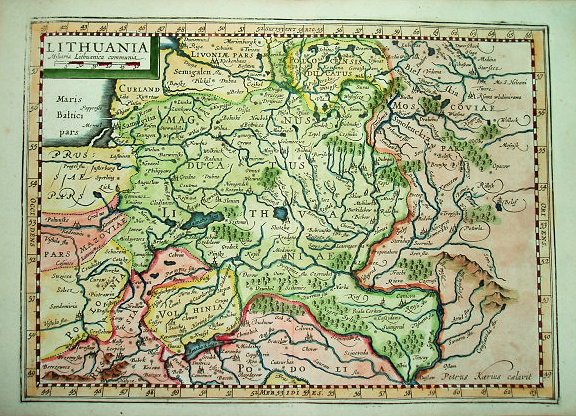
1682 Philipp Cluver:
"LITHUANIA." His “Intro-
ductionis in Universam
Geographicam,” first
published in 1624, was
re-issued from 1667 to
1729 and later. This
map, AK-11, is from a
1682 edition. See the
1676 version above.
"LITHUANIA." His “Intro-
ductionis in Universam
Geographicam,” first
published in 1624, was
re-issued from 1667 to
1729 and later. This
map, AK-11, is from a
1682 edition. See the
1676 version above.


c. 1683 - 1685 Allain Manesson Mallet: DE L'EUROPE, FIGURE 36 [OR 39], "POLOGNE," Paris, 5.5 x 4 inches, in versions from either the first (1683) or second (1685) French edition
of volume 4 [of 5] of "Description de l'Univers...," published by Denys Thierry. Colorists drew different boundaries for each version of "Pologne."
of volume 4 [of 5] of "Description de l'Univers...," published by Denys Thierry. Colorists drew different boundaries for each version of "Pologne."


1683 Pierre Moullart Sanson (original mapmaker) - Anthony d'Winter (re-engraver, after Peyrounin): "Estats de la Couronne de Pologne," Paris, 7 1/4 x 10 inches, in some versions
without the borders usually found on maps in Sanson's quarto atlas of Europe. See the original 1648 map.
without the borders usually found on maps in Sanson's quarto atlas of Europe. See the original 1648 map.


1680 Frederick de Wit (mapmaker/engraver/publisher): "Ducatuum Livoniӕ et Curlandiӕ, Nova Tabula..," Amsterdam, 42 x 50 cm / 16.4 x 19.5
inches. At the 1710 auction to liquidate the de Wit stock, most of the plates went to Pieter Mortier, whose firm eventually became Covens & Mortier.
inches. At the 1710 auction to liquidate the de Wit stock, most of the plates went to Pieter Mortier, whose firm eventually became Covens & Mortier.


1682 Pierre Duval:
'POLOGNE Royaume
Electif." Paris, 100 x 125
mm. From his "Geograph-
ie Universelle." See 1680
version. From
www.alteagallery.com
'POLOGNE Royaume
Electif." Paris, 100 x 125
mm. From his "Geograph-
ie Universelle." See 1680
version. From
www.alteagallery.com


1676 Philipp Clüver (geographer/publisher): "LITHUANIA," Amsterdam, 11
x 7.5 inches, from his "Introductionis in Universam Geographiam," printed
by Janssonius van Waesberge. First published in 1624, it was re-issued
from 1667 to 1729 and later. See the 1682 version below.
x 7.5 inches, from his "Introductionis in Universam Geographiam," printed
by Janssonius van Waesberge. First published in 1624, it was re-issued
from 1667 to 1729 and later. See the 1682 version below.


1680 Danckerts Family:
"REGNI POLONIÆ et
DUCATUS LITHUANIÆ,"
Amsterdam. Compare
with the 1682 version.
From www.swaen.com
"REGNI POLONIÆ et
DUCATUS LITHUANIÆ,"
Amsterdam. Compare
with the 1682 version.
From www.swaen.com

1677 Pierre Duval: ""Les Royaumes
du Nort ou Sont principalement les
Estats de la Couronne de Pologne..,"
Paris, in the second state of the map,
first published 1660 -- renamed and
with LaPoint's name deleted. From
Allegro,Poland: http://allegro.pl/
polska-mapa-polski-lapointe
du Nort ou Sont principalement les
Estats de la Couronne de Pologne..,"
Paris, in the second state of the map,
first published 1660 -- renamed and
with LaPoint's name deleted. From
Allegro,Poland: http://allegro.pl/
polska-mapa-polski-lapointe

1681 Herman Moll
(engraver/mapmaker):
"POLAND," London, 17.5
x 21.5 cm., from Jonas
Moore's "A New
Geography, with Maps
to each Country." From
www.alteagallery.com
(engraver/mapmaker):
"POLAND," London, 17.5
x 21.5 cm., from Jonas
Moore's "A New
Geography, with Maps
to each Country." From
www.alteagallery.com
c. 1683-85 Allain Manesson Mallet: "DE L'EUROPE, FIGURE 37, POLOGNE," Paris,
14.5 x 10.5 cm, in versions from Volume 4 [of 5] of either the first (1683) or second
(1685) French edition of "Description de l'univers...." published by Denys Thierry.
Colorists of each map painted different boundaries for "Pologne."
14.5 x 10.5 cm, in versions from Volume 4 [of 5] of either the first (1683) or second
(1685) French edition of "Description de l'univers...." published by Denys Thierry.
Colorists of each map painted different boundaries for "Pologne."


c. 1680 Moses Pitt (co-publisher) - Johannes I Janssonius van Waesbergen (co-publisher): "Magni Dvcatvs Lithvaniæ Caetrarumq Regionum illi
Adiacentium exacta decrip..." Amsterdam, 22 x 18.5 inches, in late re-issues of Janssonius' single sheet version (Blaeu also issued a single-sheet
version), itself based on Blaeu's four-sheet version of Hessel Gerritsz's 1613 map. See the attribution just above the lower left frameline: "Sumptibus
[published by] Janssonio - Waesbergiar"


1680 [dated] Nicolas Sanson: - Francis Lamb and
Richard Blome (publishers): "A MAPP of the ESTATES of
the CROWNE of POLAND..," London, 27 x 40 cm. See
the 1669 edition for notes and a different dedication.
Richard Blome (publishers): "A MAPP of the ESTATES of
the CROWNE of POLAND..," London, 27 x 40 cm. See
the 1669 edition for notes and a different dedication.


1680 Janssonius Family
(mapmakers) - Moses Pitt
(publisher): "Nova Totvs
Livoniæ," Amsterdam,
15.4 x 20.3 inches), from
Pitt's "The English Atlas."
First published 1636, see
versions from 1637, 1638,
1641 and 1642. From
www.sanderusmaps.com
(mapmakers) - Moses Pitt
(publisher): "Nova Totvs
Livoniæ," Amsterdam,
15.4 x 20.3 inches), from
Pitt's "The English Atlas."
First published 1636, see
versions from 1637, 1638,
1641 and 1642. From
www.sanderusmaps.com


1683 William Berry (mapmaker/publisher): "Poland Subdivided according to the
Extent of its severall Palatinates ...Dedicated To the most serene and most sacred
majesty of Charles II...," London, 53.2 x 85.3 cm. Described on the map as Berry
correcting/amending Sanson's work, but actually based on Jaillot's reworking of
Sanson's map. The largest map of Poland published at the time. See the Bowles 1744
version.


| FIGURE XXXVII pg 93 |
1683 (dated on Volume 4 of 5 of the first, and French, edition of Allain Manesson Mallet's:
"Description de l'univers..,." published in Paris by Denys Thierry. These three maps are on
consecutive right-hand pages of the copy in the possession of the New York Public Library: the
page numbers make sense, but the "Figure" Roman numerals are out of sequence. Also, the
third map appears to be printed from the same plate as the second map, with the addition of
the phrase "Tome III" on the lower page margin. Why this third map was bound into the atlas,
I can't explain -- but it illustrates the difficulty of accurately identifying the provenance of one
of these maps merely by the plate image. From The New York Public Library's Rare Book Room

1677 [dated] Nicholas Sanson (carto-
grapher) - Johann Hofmann (publisher):
"Regni Poloniæ prout dividitur in suos
Palatinatus..." Nürnberg, in two joined
sheets, each 46 x 60.8 cm. From National
Library of Poland via www.mapywig.org
grapher) - Johann Hofmann (publisher):
"Regni Poloniæ prout dividitur in suos
Palatinatus..." Nürnberg, in two joined
sheets, each 46 x 60.8 cm. From National
Library of Poland via www.mapywig.org


1681 Pierre Duval: "POLONIÆ
Regnum," Paris, 13 x 12 cm, from
his "Geographiæ Universalis."
From maklize on eBay
Regnum," Paris, 13 x 12 cm, from
his "Geographiæ Universalis."
From maklize on eBay


1677 [dated] Henricus
Hondius III: "Livoniæ et
Curlandiæ descriptio,"
Amsterdam. From The
National Library of Finland:
http://www.doria.fi/
Hondius III: "Livoniæ et
Curlandiæ descriptio,"
Amsterdam. From The
National Library of Finland:
http://www.doria.fi/


| www.bergbook.com |
| Digital Library of Wrocław University, via www.mapywig.com |
| Univ. of Freiburg: http:// dl.ub.uni-freiburg.de/ |
| Konnklijke Bibliotheek, The Hague, |
| www.bergbook.com |
| www.raremaps.com |
| www.raremaps.com |
| www.sanderusmaps.com |
| Univ. of Tartu, Estonia: www.dspace.utlib.ee/ |
| Univ. of Tartu, Estonia: www.dspace.utlib.ee/ |
| www.sanderusmaps.com |
| http://oldprintshop.com/ |

| www.jpmaps.co.uk |
| www.raremaps.com |
| Norman B. Leventhal Map Center at the Boston Public Library: www.leventhalmap.org |
| www.abrahambock.com |
| www.davidrumsey.com |
| LIETUVOS DAILĖS FONDAS: .ldfondas.lt/ |
| www.alteagallery. com |
| www.bergbook.com |
| LIETUVOS DAILĖS FONDAS: .ldfondas.lt/ |
| FIGURE XXXVI pg 95 |
| FIGURE XXXIX pg 97 |
| gkgrec on eBay |
| odetowhitman on eBay |
| bertius on eBay |
| www.robertfrew.com |
| wikimedia |
| LIETUVOS DAILĖS FONDAS: .ldfondas.lt |
| www.themaphouse.com |
| wikimedia |
| wikimedia |
| www.raremaos.com |
| The Portsmouth Bookshop |
| www.karty.by |
| www.aspireauctions.com |

| www.raremaps.com |

| www.antique-maps.lt |

| Royal Danish Library: www.kb.dk |


| dive13 on eBay |
| www.swaen.com |

| Royal Danish Library: www.kb.dk |


| www.raremaps.com |

1679 Adam Friedrich Zürner (priest/cartographer):
"POLONIA & LITHUANIA Cum suis Palatinatibus,"
Amsterdam, 10.5 x 8 inches, from his edition of Sanson's
"Atlas of the world."
"POLONIA & LITHUANIA Cum suis Palatinatibus,"
Amsterdam, 10.5 x 8 inches, from his edition of Sanson's
"Atlas of the world."

c. 1680 (Anon.): "Regni
POLONIAE Nova
Descriptio," 12 x 7.5
inches, first time seen.
From www.raremaps.com
POLONIAE Nova
Descriptio," 12 x 7.5
inches, first time seen.
From www.raremaps.com

| www.sanderusmaps.com |
| Beinecke Collection: www. brbl-dl.library.yale.edu |

| https://oshermaps.org/ |

| goldendrake on eBay |

| www.swaen.com |

| www.raremaps.com |
| www.mapywig.org |

| www.raremaps.com |

| www.polona.pl |
| www.raremaps.com |

| aliakseia on eBay |


| www.swaen.com |

| https://artinfo.pl/ |


| www.swaen.com |
1680 Robert Morden - Francis Lamb (engraver): "A
New Mapp of the Estates of the Crown of Poland.
Containing: the Kingdom of Poland the Dutchies &
Provinces of Prussia..," London, 22 x 17.3 inches /
56.5 x 44.2 cm, in the Second State. The First State
was published 1672.
New Mapp of the Estates of the Crown of Poland.
Containing: the Kingdom of Poland the Dutchies &
Provinces of Prussia..," London, 22 x 17.3 inches /
56.5 x 44.2 cm, in the Second State. The First State
was published 1672.

| www.oldworldauctions.com |

| designer_corner _squared on eBay |

| designer_corner_squared on eBay |

| oldmapsoldbooks on eBay |

| Beinecke Collection: www. brbl-dl.library.yale.edu |

| Martynas Mažvydas National Library of Lithuania https: //nbdb.libis.lt/ |
| www.antique-maps.lt |

| National Library of Poland via www.mapywig.org |


| www.kolekcijos.biblioteka .vu.lt |

| NEW March 30 |
| National Library of Poland via www.mapywig.org |