Maps: 1696 - 1700
c. 1696 Carel Allard (engraver/publisher): "Regni Poloniæ, Magni Ducatus Lithuaniæ cœterarumque Regi Poloniæ subditarum Regionum Tabula," with a "Cum Privilegio
Ordinum Hollandiae et Westfr.," Amsterdam, 50 × 58.50 cm / 19.7 x 23 inches, in versions from his "Atlas Major," issued in multiple undated editions both by Carel and later
by his son Hugo.
Ordinum Hollandiae et Westfr.," Amsterdam, 50 × 58.50 cm / 19.7 x 23 inches, in versions from his "Atlas Major," issued in multiple undated editions both by Carel and later
by his son Hugo.
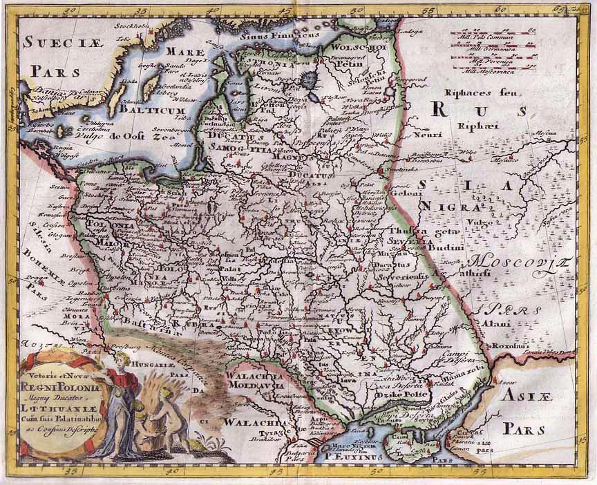
1697 Philipp Clüver - Typis Joannis Wolters (Amsterdam publisher) - Sam. Smith & Benj. Walford (London publisher): "Veteris et Novæ Regni Poloniæ Magniq Ducatus Lithuaniæ..," Leyden and London, 25 x 28 cm / 8.5 x 10 inches, in the
second Latin version of the plate from "Introductionis in Universam Geographicum," issued from 1624 (with no maps) until 1729 -- when it had this same plate. Note the different eastern boundaries for Lithuania, ignoring the dotted-line
boundaries visible in the uncolored version.
second Latin version of the plate from "Introductionis in Universam Geographicum," issued from 1624 (with no maps) until 1729 -- when it had this same plate. Note the different eastern boundaries for Lithuania, ignoring the dotted-line
boundaries visible in the uncolored version.
1697 [dated] Jean Baptiste Nolin I (publisher): "LE ROYAUME de POLOGNE, Comprenant les Etats de Pologne et de
LITHUANIE..." Paris, 17.7 x 22.8 inches / 45.0 x 57.8 cm, prepared by Jean Nicholas Du Tralage (sieur de
Tillemont), who revised maps by Coronelli for Nolin.
LITHUANIE..." Paris, 17.7 x 22.8 inches / 45.0 x 57.8 cm, prepared by Jean Nicholas Du Tralage (sieur de
Tillemont), who revised maps by Coronelli for Nolin.
1699 Guillaume
Levasseur de Beauplan -
Allard (publisher): "Nova
totius regni Poloniæ,
magniq. ducatus Lithu-
aniæ" 39 x 51 cm, from
"Atlas Major." From Royal
Danish Library: www.kb.dk
Levasseur de Beauplan -
Allard (publisher): "Nova
totius regni Poloniæ,
magniq. ducatus Lithu-
aniæ" 39 x 51 cm, from
"Atlas Major." From Royal
Danish Library: www.kb.dk

1699 Pierre Duval -
Francois de Lepine (who
signed himself as
"Lapointe" on the maps he
engraved): "Les royaumes
du nort." From
www.gallica.bnf.fr
Francois de Lepine (who
signed himself as
"Lapointe" on the maps he
engraved): "Les royaumes
du nort." From
www.gallica.bnf.fr

c. 1700 Danckerts Family: "Regni Poloniӕ et Ducatus Lithuaniӕ Voliniӕ Podoliӕ Vcraniӕ Prvssiӕ et Cvrlandiӕ," Amsterdam, 49 x 58 cm, in the Second State, with Danckerts'
"Cum Privelegio," granted 1684, and renewed 1699 for another 15 years. See c. 1690 for the First State.
"Cum Privelegio," granted 1684, and renewed 1699 for another 15 years. See c. 1690 for the First State.
1700 Nicolas de Fer: "Carte Des Estats De Suede, De Dannemarq, Et De Pologne
sur la Mer Baltique [right cartouche]; Estats des Couronnes de Dannemark,
Suede, et Pologne fur la Mer Baltique" [left cartouche], Paris, 17.3"x 27.7 as
two joined sheets, x 14.1 inches as a right-side map, in two different versions of
the right half, and a joined version. At the bottom of the right cartouche: "Avec
Privilege du Roy 1700." See the 1705 versions.

1700 Johann Stridbeck II, The Younger:
"Compendiosa POLONIÆ Representatio..,"
from the atlas "Provinciarum Polonia Geog.
Descriptio," Augsburg. Supposedly the first
atlas of Poland in small format. On
Stridbeck's death in 1716, the plate passed
on to Gabriel Bodenehr, who made changes
to the cartouche, and published the maps
as his own. From The National Library of Poland,
via www.mapywig.org
1700 Edward Wells (teacher/mapmaker) - Sutton Nicholls (engraver): "A New Map of Present POLAND, HUNGARY WALLACHIA, LITTLE TARTARY," Oxford, 37 x 51 cm, in three
versions. This is one of a set of 22 maps from "A New Sett of Maps Both of Antient and Present Geography," published 1700 - 1738. The atlas contains, in most cases, two of each map to
compare the ancient and modern configurations. Compare with the 1712 versions. Also see the "Antient" version of this map, titled "Sarmatia, in "MapsEthnographic." All the maps in
the atlas are dedicated to the just-deceased 11-year-old William, Duke of Gloucester, son of Princess -- later Queen -- Anne.

c. 1700 Frederick de Wit: "Reipublicæ et Status Generalis POLONIÆ Nova Tabula, Comprehendens Maioris et Minoris Poloniæ Regni, Magni
Ducatus Lithvaniæ Ducatus Prussiæ, Curlandiæ, Russiæ Vcraniæ, Massoviæ, Volhyniæ et Podoliæ," Amsterdam, 22 x 19 inches, in three
versions of the Third State of the cartouche, with a new title, the privilege, and a mileage chart. See 1680-85 First State versions, the
1689 Second State versions with a privilege and mileage chart, and the c1690 van Schragen version. Three or four ships in the Baltic in
each -- a buyer option.


1699 Sanson et Fils:
"ESTATS de la Couronne
de POLOGNE," 8 x 10.5
inches, Amsterdam,
engraved by d'Winter,
issued by Arnout van
Ravestein. From
oldmapsoldbooks on eBay
"ESTATS de la Couronne
de POLOGNE," 8 x 10.5
inches, Amsterdam,
engraved by d'Winter,
issued by Arnout van
Ravestein. From
oldmapsoldbooks on eBay
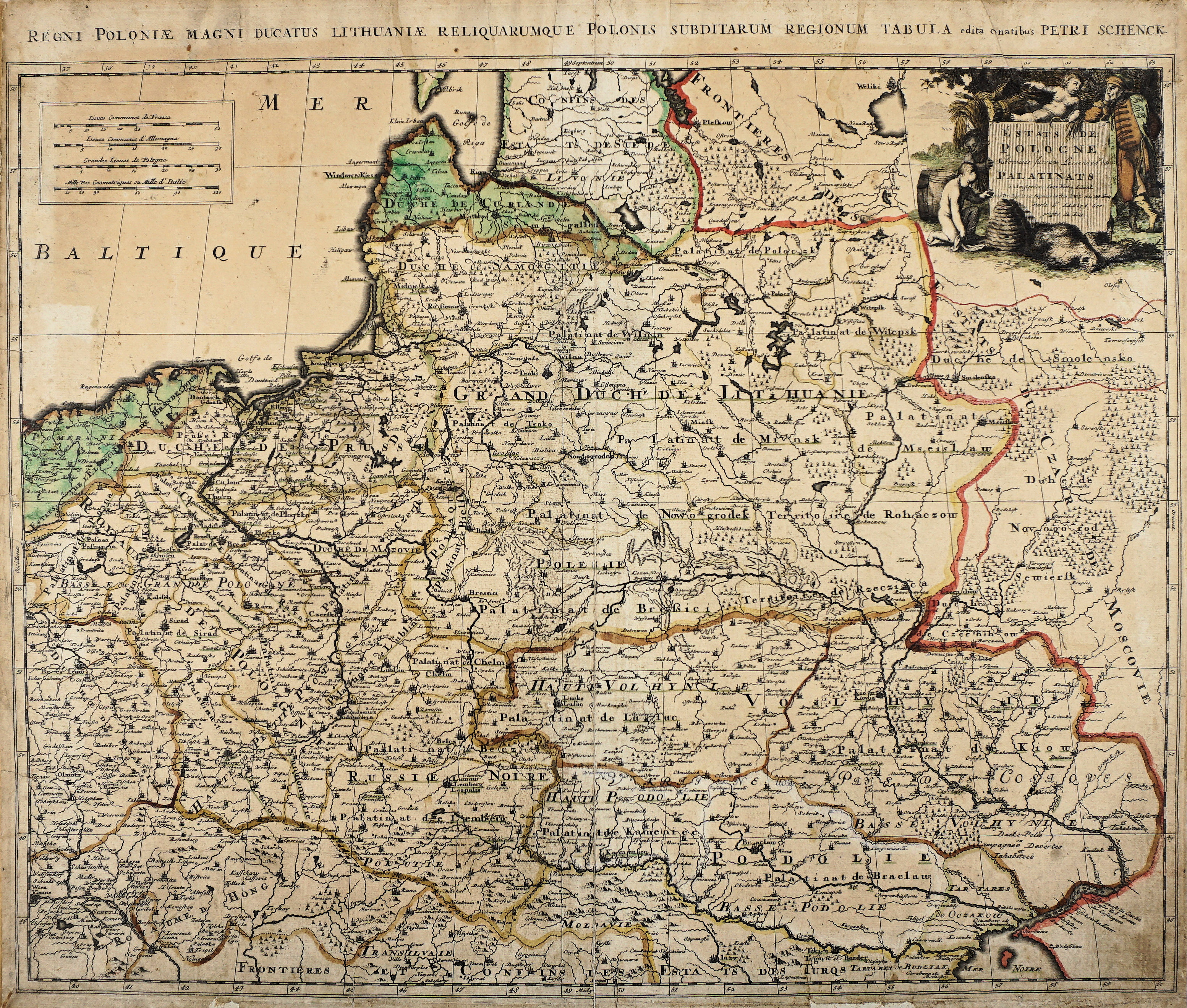
1700 Petrus Schenk I (engraver/publisher): "Estats de Pologne Subdiveses suivant l'estendue des Palatinats." Amsterdam, 46.4 x 58.2 cm / 23 x 18.5 inches.
The map is a copy of an earlier map by Sanson, and was published in "Atlas Contractus sive Mapparum Geographiacarum..." See the 1740 versions.
The map is a copy of an earlier map by Sanson, and was published in "Atlas Contractus sive Mapparum Geographiacarum..." See the 1740 versions.
1697 [dated] Nicolas de Fer - C. Iselin (engraver): "Les
Estats de la Couronne de Pologne," Paris, 5.5 x 7.9
inches, from the first edition of Fer's "Petit et Nouveau
Atlas." See the 1705 second edition version.
Estats de la Couronne de Pologne," Paris, 5.5 x 7.9
inches, from the first edition of Fer's "Petit et Nouveau
Atlas." See the 1705 second edition version.


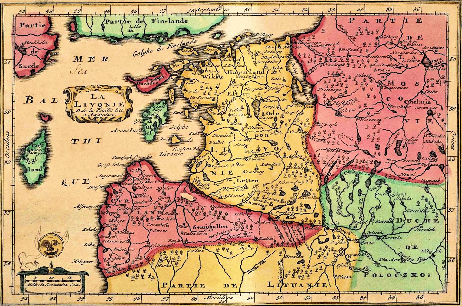
1698 Christoph Weigel (engraver/ publisher):
"Livoniæ et Cvrlandiæ Tabula," Nürnberg,
from his atlases 1698 - 1720. From
https://www.digar.ee/viewer/en/nlib-digar
"Livoniæ et Cvrlandiæ Tabula," Nürnberg,
from his atlases 1698 - 1720. From
https://www.digar.ee/viewer/en/nlib-digar

1698 "ESTATS DE LA
COURONNE DE
POLOGNE." From
www.karty.by
COURONNE DE
POLOGNE." From
www.karty.by


1700 Gerard Valck: "Tabula DUCATUUM LIVONIÆ et CURLANDIÆ..." Amsterdam, 23 x 19 inches, in six differently-colored versions.


1698 M. Le Coq (publisher) - Pierre Ganiere (engraver): "LA POLOGNE,"
Paris, 24 x 15.5 cm / 9 x 6 inches, from "La Parfait Geographie ou
L'Art D'Apprende ..."
Paris, 24 x 15.5 cm / 9 x 6 inches, from "La Parfait Geographie ou
L'Art D'Apprende ..."


1699 Heinrich Scherer:
"POLONIA CVM
LITHVANIA..." Munich,
23.5 x 36 cm. From his
"Atlas Novus," 8 volumes,
187 plates, published
1698 - 1710. From
Bibliotheque nationale de
France: www.gallica.bnf.fr
"POLONIA CVM
LITHVANIA..." Munich,
23.5 x 36 cm. From his
"Atlas Novus," 8 volumes,
187 plates, published
1698 - 1710. From
Bibliotheque nationale de
France: www.gallica.bnf.fr


1700 Daniel de La
Feuille: "LA LIVONIE,"
Amsterdam, 16 x 22.3
cm. From the National
Library of Latvia: www.lnb.lv
Feuille: "LA LIVONIE,"
Amsterdam, 16 x 22.3
cm. From the National
Library of Latvia: www.lnb.lv

1696 Danckerts Family: "Ducatuum Livoniæ et Curlandiæ Novissima Tabula in Quibus sunt Estonia Litlandia..," Amsterdam, 47 x 56 cm. See the 1684 versions.

1700 Pieter van der Aa:
"LA POLOGNE, Suivant
les NouvellesObserva-
tions..." Amsterdam, 15 x
10.5 inches, which also
appeared in his "Nouvelle
Theatre Du Monde,"
1713. From
www.raremaps.com
"LA POLOGNE, Suivant
les NouvellesObserva-
tions..." Amsterdam, 15 x
10.5 inches, which also
appeared in his "Nouvelle
Theatre Du Monde,"
1713. From
www.raremaps.com


1696 Alexis-Hubert Jaillot - Pierre
Mortier (publisher): "Estats de la
Couronne de POLOGNE: presenté A
Monseigneur le Duc de Bourgogne,"
Amsterdam, 48.5 x 60.5 cm. See the
sixth, 1792, version of this map by
Jan Barend Elwes. From www.polona.pl
Mortier (publisher): "Estats de la
Couronne de POLOGNE: presenté A
Monseigneur le Duc de Bourgogne,"
Amsterdam, 48.5 x 60.5 cm. See the
sixth, 1792, version of this map by
Jan Barend Elwes. From www.polona.pl

| wikicommons |


| The two-sheet map, combined www.alexandremaps.com |


1700 Renier and Joshua Ottens
(publishers): "Ducatuum Livoniæ
et Curlandiæ Novissima Tabula in
Quibus sunt Estonia Litlandia..,"
Amsterdam, 19.0 x 22.6 inches /
48.2 x 57.5 cm. From
www.swaen.com
(publishers): "Ducatuum Livoniæ
et Curlandiæ Novissima Tabula in
Quibus sunt Estonia Litlandia..,"
Amsterdam, 19.0 x 22.6 inches /
48.2 x 57.5 cm. From
www.swaen.com
1697 [dated 1663]
Nicolas Sanson I (d'Abbe-
ville): "La Livonie Duche"
Paris, from a 1697 edition
of "Cartes et Tables de la
Geographie Ancienne et
Nouvelle..." published by
his son, Guillaume Sanson.
See 1663 version. From
www.davidrumsey.com
Nicolas Sanson I (d'Abbe-
ville): "La Livonie Duche"
Paris, from a 1697 edition
of "Cartes et Tables de la
Geographie Ancienne et
Nouvelle..." published by
his son, Guillaume Sanson.
See 1663 version. From
www.davidrumsey.com

| Harvard Map Library via wikimedia |
| www.raremaps.com |
| www.karty.by |
| www.antique-maps.lt |
| John Carter Brown Library: https://jcb.lunaimaging.com/ |
| Univ. of Vilnius Library: https://kolekcijos.biblioteka.vu.lt/ |
| www.oshermaps.org |
| Bibliotheque nationale de France: www.gallica.bnf.fr |
| www.raremaps.com |
| Freiburg University, Germany: http://dl.ub.uni-freiburg.de |
| www.raremaps.com |
| arlusatica on eBay |
| https://antique-maps.lt/ |
| www.swaen.com |
| www.nlib.ee |
| www.alexandremaps.com |
| www.raremaps.com |
| www.sanderusmaps.com |
| www.raremaps.com |
| http:// digital.ub.uni-duesseldorf.de/ |
| Univ. of Leipzig, Germany: http://dl.ub.uni-freiburg.de/ |
| www.raremaps.com |
| http://digital.ub.uni-duesseldorf.de |
| www.raremaps.com |
| DSpace at the Univ. of Tartu: http://dspace.utlib.ee/dspace |
| www.raremaps.com |
| www.antiquariat@dahor.de |
| www.davidrumsey.com |
| LIETUVOS DAILĖS FONDAS: .ldfondas.lt/ |
| www.oldworldauctions.com |


1700 Paolo Petrini (publisher): "Stati Della Corona Di Polonia Divisa nele sue Principali
Provincie e Palatinati..," Naples, 16.5 x 21.5 inchesi, in "unfinished" or "proof" versions,
and in a "finished" version. Petrini's maps are typically based upon the work of French
Royal mapmaker Nicolas Sanson, although the present example gives credit to Nicolas's
son, Guillaume.
Provincie e Palatinati..," Naples, 16.5 x 21.5 inchesi, in "unfinished" or "proof" versions,
and in a "finished" version. Petrini's maps are typically based upon the work of French
Royal mapmaker Nicolas Sanson, although the present example gives credit to Nicolas's
son, Guillaume.


| Royal Danish Library: www.kb.dk |


| wikimedia |
| Royal Danish Library: www.kb.dk |


| wikimedia |
| www.polonia.pl |
1697 - 1700 Danckerts Family: "Regni Poloniæ et Ducatus Lithuaniæ..," Amsterdam.
Which Cornelis? Cornelis III was grandson of Cornelis the Elder, founder of the
Danckerts firm of engravers and publishers which lasted until 1726, when their
stock and plates were sold to Ottens and Van Keulen, among others. See the 1706-10
version, and the 1726 and later Ottens versions with a slightly altered cartouche.


1696 Guillaume Le
Vasseur de Beauplan
(mapmaker) - Jacob von
Sandrart (engraver/
publisher): "Nova totius
Regni Poloniæ Mag'nique
Ducatus Lituaniæ..,"
Nuremberg. Late version
of 1675 first edition. From
www.kettererkunst.com
Vasseur de Beauplan
(mapmaker) - Jacob von
Sandrart (engraver/
publisher): "Nova totius
Regni Poloniæ Mag'nique
Ducatus Lituaniæ..,"
Nuremberg. Late version
of 1675 first edition. From
www.kettererkunst.com
| www.thesale-room.com |
| www.reiss-sohn.de |
1697 Guillaume Le Vasseur de Beauplan (mapmaker) -
Jacob von Sandrart (engraver/ publisher): "Nova totius
Regni Poloniæ Mag'nique Ducatus Lituaniæ..," Nurem-
berg. The first edition had a portrait of King Johannes III
Sobieski. In the 2nd - 6th editions, Sobieski's portrait is
replaced by one of King Augustus II, following Sobieski's
death in 1696. Both images between the 4th and 5th,
with Sandrart's address erased in the 5th state.


| European Library.org, via National Library of Latvia |
| Universitätsbibliothek Bern www.e-rara.ch |

| Harvard Map Library: www.curiosity.lib.harvard.edu/ |
| www.antique-maps.lt |
| www.antique-maps.lt |


| www.raremaps.com |


| Cartographic and Geological Institute of Catalonia: https://cartotecadigital.icgc.cat/digital/collection |

| luschnoar on eBay |

| www.antique-maps.lt |

| www.lpmaps.lt |

| designer_corner_squared on eBay |

| designer_corner_squared on eBay |

1697 Daniel de La Feuille
(mapmaker/engraver):
"LE ROYAVME DE
POLOGNE AVEC SES
CONFINS," Leipzig, 13 x
17.5 cm, the 1st State of
the 5th Plate.www.lpmaps.lt
(mapmaker/engraver):
"LE ROYAVME DE
POLOGNE AVEC SES
CONFINS," Leipzig, 13 x
17.5 cm, the 1st State of
the 5th Plate.www.lpmaps.lt
| www.digar.ee/arhiiv/en |


| National Library of Poland via www.mapywig.org |

| "Unfinished" cartouche www.raremaps.com |
| "Finished" cartouche www.raremaps.com |

| "Unfinished" cartouche https://kolekcijos.biblioteka. vu.lt/ |

| NEW March 30 |


| NEW March 30 |
| NEW March 30 |
| National Library of Poland via www.mapywig.org |
| National Library of Poland via www.mapywig.org |